Summary
Early Severe Weather Threat Detected
The Onset of Severe Weather Approaches
Severe Weather Ingredients
Radar Analysis
Siesta Key / Sarasota EF-2 Tornado
Manatee County / Duette EF-2 Tornado
Additional Storms on the 17th
|
|
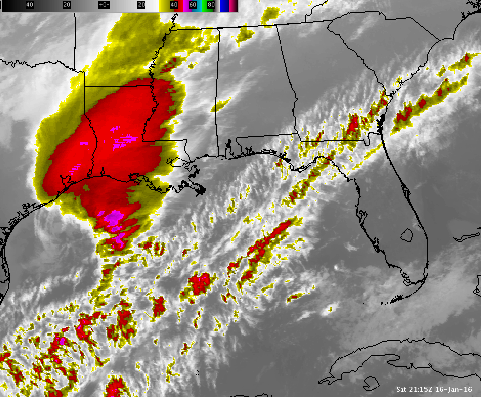
IR Satellite Loop Satellite loop of low pressure developing off the upper Texas coast, and quickly translating eastward across the Gulf of Mexico during January 16th and early January 17th. The bright purple colors represent vigorous thunderstorm cloud tops approaching, and eventually moving over the Florida Peninsula during the early morning hours of January 17th. |
Top
A potent storm system developed and tracked quickly eastward across the Gulf of Mexico, and toward the state of Florida during Saturday January 16th, 2016. The impacts from this storm reached west-central and southwest Florida during the early morning hours of Sunday January 17th, 2016. This storm system represented a classic setup for a strong El Nino tornado outbreak across the Florida peninsula. Preparation and public outreach efforts for just such an event, given the ongoing strong El Nino, had been underway at the NWS office in Ruskin for several months.
A squall line of strong and severe thunderstorms organized and quickly moved eastward during the 16th across the western and central gulf of Mexico ahead of a cold front. This line of storms approached the Florida west coast after 2 AM EST on the 17th. Just ahead of this squall line, individual supercell thunderstorms developed and moved quickly northeastward toward the coast, south of the Tampa Bay area.
Multiple fast moving supercell thunderstorms crossed the southwest Florida coast, with one particular storm producing at least two confirmed EF-2 tornadoes. The first tornado came ashore near the Siesta Key/Sarasota area before briefly lifting. The same supercell then shortly thereafter produced another EF-2 tornado further inland, over northeast Manatee County, near the town of Duette.
A squall line of strong to severe thunderstorm, just ahead of the cold front, continued to produce periodic wind damage and isolated tornadoes as it quickly moved ashore across west-central and southwest Florida, and pushed across the state. The severe weather event, which started after midnight on the 17th, ended quickly that same morning, as the squall line exited the Florida east coast into the Atlantic Ocean.
Top
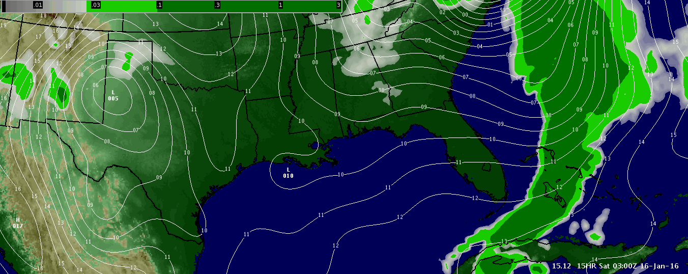
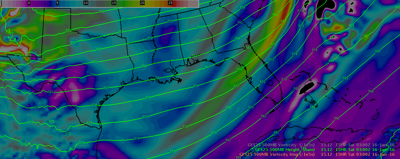
The potential for severe weather was predicted several days in advance by many of the Numerical Weather Prediction (NWP) models. Below we see the NCEP Global Forecast System (GFS) model forecast from the morning of the 15th. The mean sea-level pressure and precipitation potential are on the left, and the 500mb (approx. 20KFT) heights and absolute vorticity are shown on the left. At this early time, and even up to two days earlier, many indicators were pointing toward an unusually potent Gulf of Mexico low pressure system impacting the Florida Peninsula on the 17th.
|
|
|
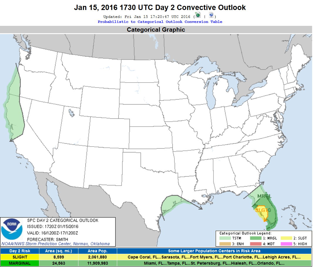
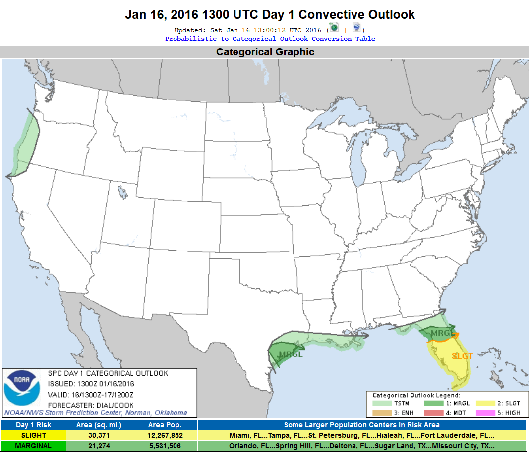
The Storm Prediction Center (SPC), on the afternoon of the 15th, began to outlook a portion of southwest Florida in a Slight Risk for severe weather, valid during the morning of the 17th (left panel below). The Slight Risk area was expanded to include all of central and southern Florida, along and to the south of the I-4 corridor, on the morning of the 16th (right panel below).
|
|
|
http://www.spc.noaa.gov/products/outlook/archive/2016/day2otlk_20160115_1730.html
http://www.spc.noaa.gov/products/outlook/archive/2016/day1otlk_20160116_1300.html
Top
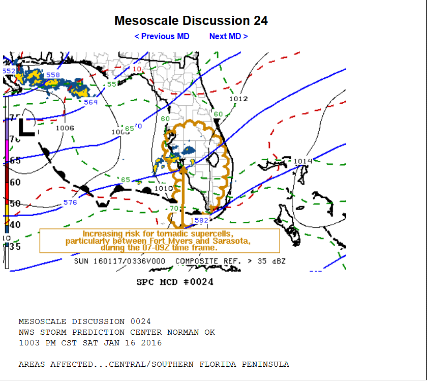
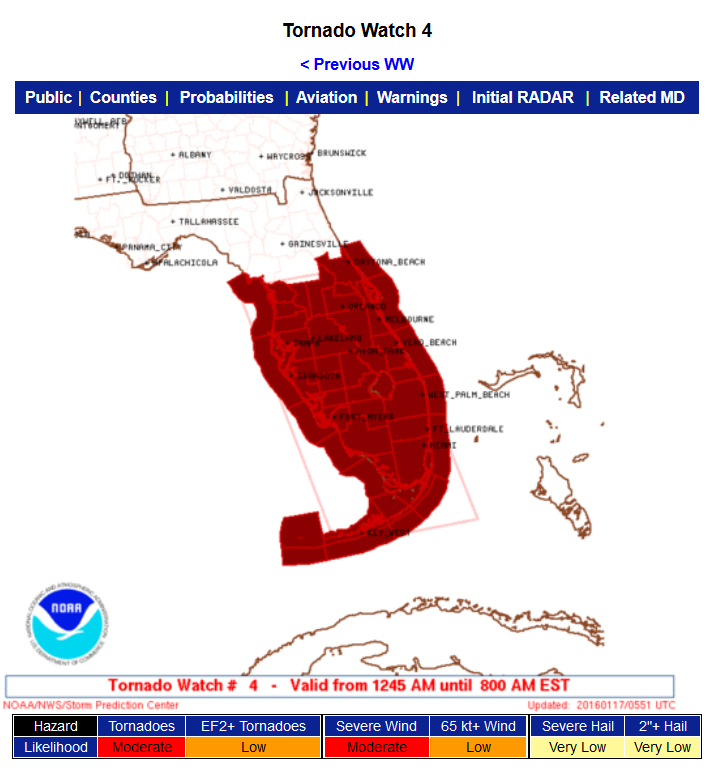
The Storm Prediction Center (SPC) issued the first Mesoscale Discussion for Florida at 1103 PM EST (left panel below) concerning the increasing risk for tornadic supercells between Fort Myers and Sarasota during the upcoming early morning hours, and to indicate that a tornado watch would likely be required. After coordination with the NWS offices in Tampa, Melbourne, Miami, and Key West, SPC issued a Tornado Watch (right panel below) at 1245 AM EST. This watch covered all of central and southern Florida.
|
|
|
http://www.spc.noaa.gov/products/md/md0024.html
http://www.spc.noaa.gov/products/watch/ww0004.html
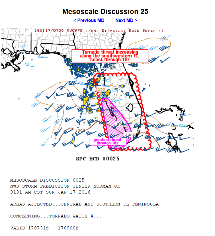
An updated mesoscale discussion was issued by SPC at 231 AM EST, highlighting an ever increasing tornado threat along the southwest Florida coast.
|
|
http://www.spc.noaa.gov/products/md/md0025.html
Top
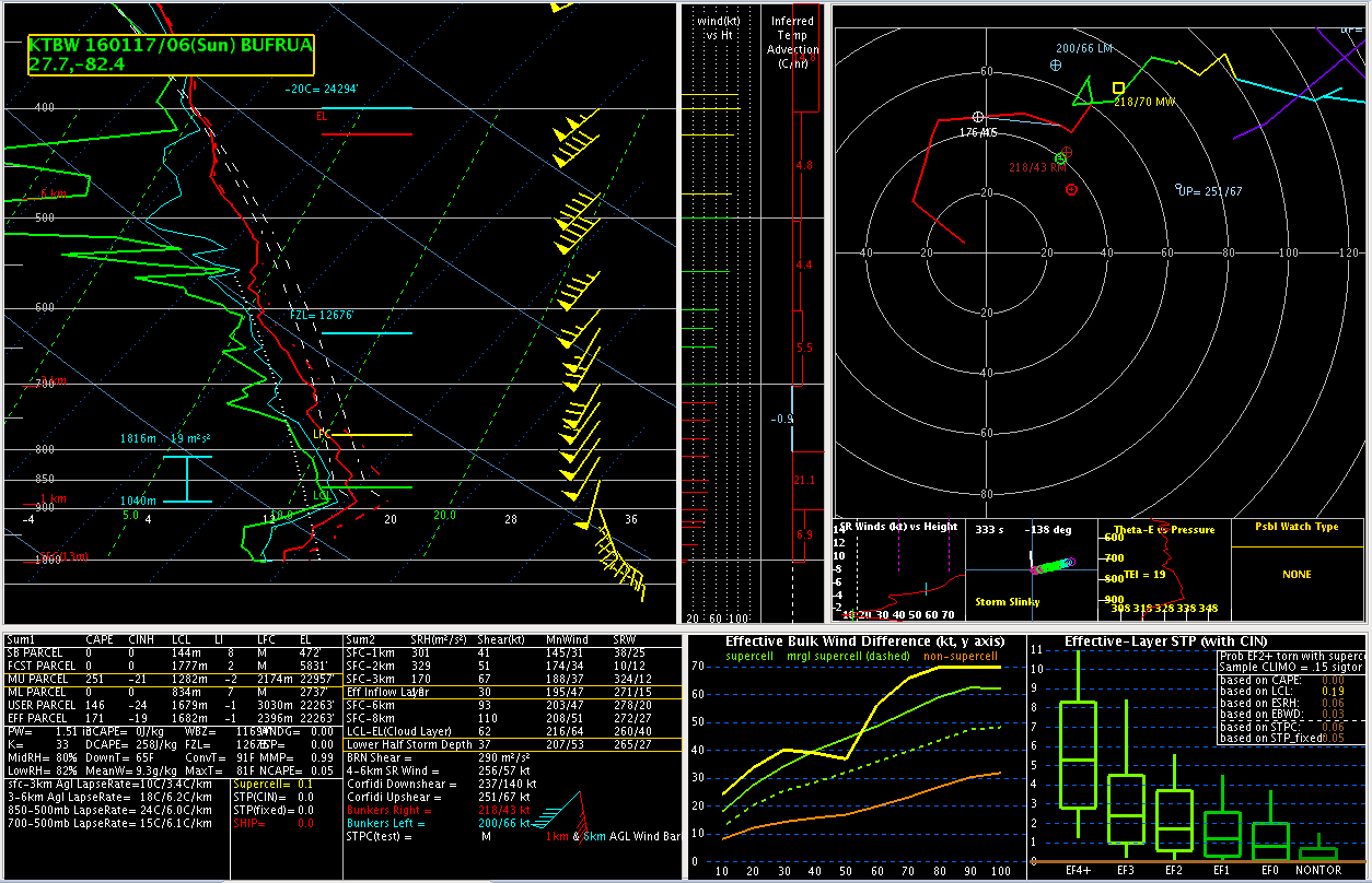
The conditions necessary for severe weather that had been anticipated for several days began to come together during the early morning hours of the 17th. In order to increase situational awareness of the developing volatile conditions, Florida NWS offices conducted non-standard 06Z (1 AM EST) weather balloon launches. These profiles of the atmosphere give meteorologists a true window on the current conditions and allow for better anticipation of the potential impacts from severe weather over the upcoming hours.
Below we see the data from the 06Z KTBW balloon launched from the NWS office in Ruskin, FL. This balloon launch confirmed the existence of the dangerous vertical wind profiles that had been forecast by many of the NWP models during previous days. The profile shows strong wind fields that veer quickly with height above the surface. This type of wind profile is one commonly associated with the development and maintaining of supercell thunderstorms, and increased potential for the spawning of tornadoes.
|
|
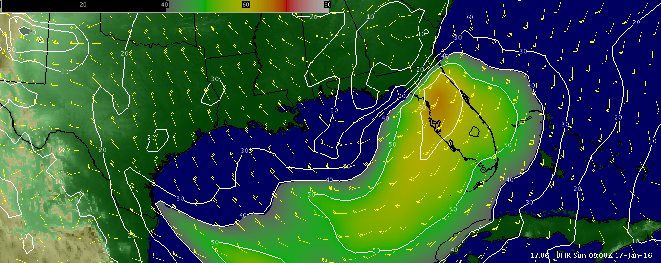
In addition to the highly veered winds with height above the ground, these winds above the surface had become very strong. The graphic below shows the powerful 60+ knot low level 850mb (approx. 5KFT AGL) southerly jet streak from the 06Z model run of the GFS during the pre-dawn hours of the 17th. Not only do these strong winds aloft aid the rotation of supercell thunderstorms and tornado development, but can also be redirected down to the surface within thunderstorms as damaging straight-line winds.
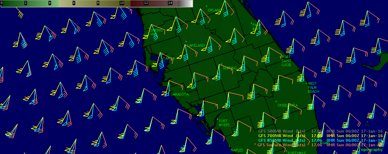
The graphic below shows the favorable environment for supercell thunderstorms from the GFS model in another way. The orange wind barbs show predicted winds at the surface, the blue wind barbs show predicted winds at 850mb (approx. 5KFT), and the yellow wind barbs show predicted winds at 700mb (approx. 10KFT). This veering, or clockwise turning of the winds with height, combined with the increasing wind speed with height, produce favorable wind shear, supportive of rotating supercell thunderstorms and potential tornadoes.
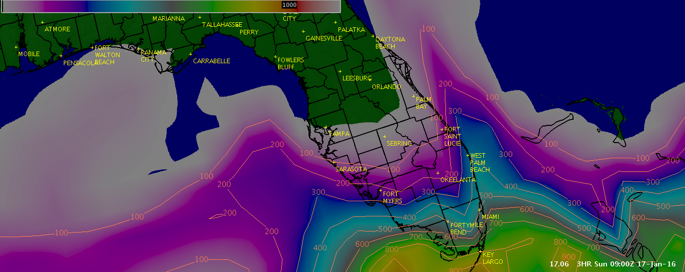
The final graphic in this section show the surface based Convective Available Potential Energy (CAPE) from the GFS early in the morning on the 17th. CAPE is a measure of instability, and surface based cape is an essential ingredient to severe weather occurring at the ground. Where surface based CAPE does not exist, strong winds from aloft and rotation related to potential tornado development has a much harder time reaching all the way down to ground level. Meteorologists use the analysis of CAPE to help determine where severe straight-line winds and tornadic development is most likely, or even possible. Radar is always sampling at some particular level above the ground. Although strong winds or strong tornadic rotation may be present in the radar data, if no surface based CAPE is present, it is much less likely that these features will ever reach the surface to endanger life and property. This combination of radar meteorology, with careful analysis of the low level environment below the radar features of interest are both critical aspects of the warning decision methodology.
In this image, the white into pinks and blues represent where surface based CAPE is expected to be present. CAPE at the surface was generally only present to the south of the I-4 corridor early on the 17th. Wind shear was certainly just as favorable to support supercells and severe thunderstorms to the north of the I-4 corridor early on the 17th, however, it is no coincidence that most of the severe weather reports, and all of the tornadoes occurred further south, within this zone where surface based CAPE was present.
Top
|
|
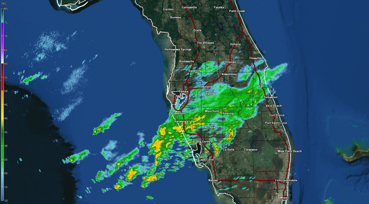
Radar Reflectivity Full Event Loop Here is a radar reflectivity loop covering the entire severe weather event. The loop begins around 11 PM on the 16th, as lighter rain overspread from the Gulf of Mexico. The loop ends roughly 8 hours later as the last of the thunderstorms push east of the NWS Ruskin forecast area. |
Reflectivity loop of entire severe weather event: 0.5 tilt
Top
|
|
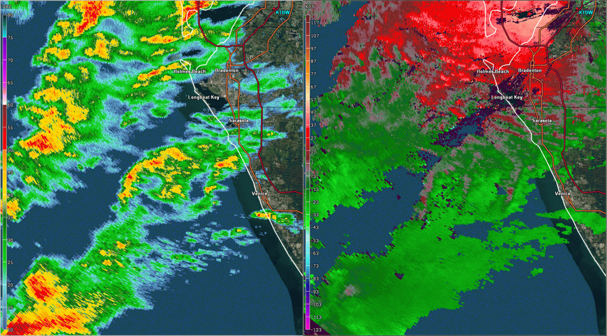
Sarasota / Siesta Key Supercell & Tornado Radar loop focusing on the tornadic supercell that spawned the first EF-2 tornado. This supercell maintained strong rotation and likely cyclical tornado formation as it moved rapidly across the coastal waters, and finally crossed the FL west coast near Siesta Key in Sarasota County. |
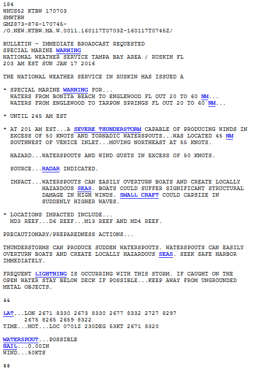
Special Marine Warning (SMWTBW): 203 AM EST January 17th, 2016
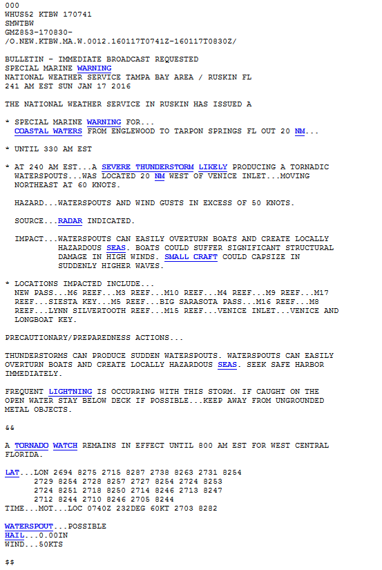
Special Marine Warning (SMWTBW): 241 AM EST January 17th, 2016
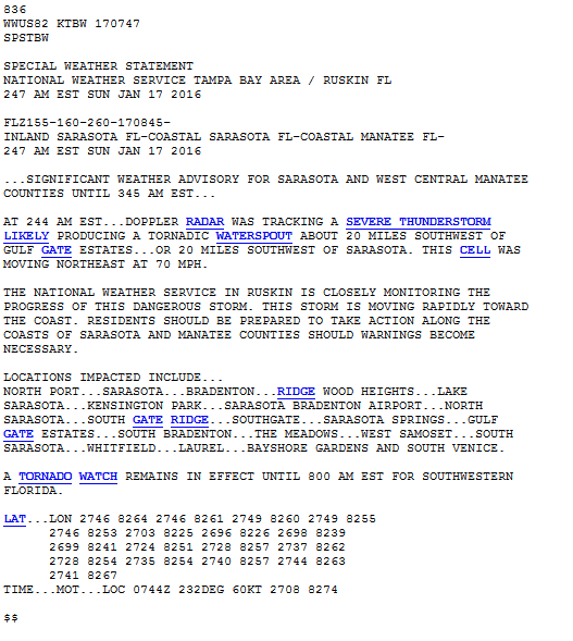
Significant Weather Advisory (SPSTBW): 247 AM EST January 17th, 2016
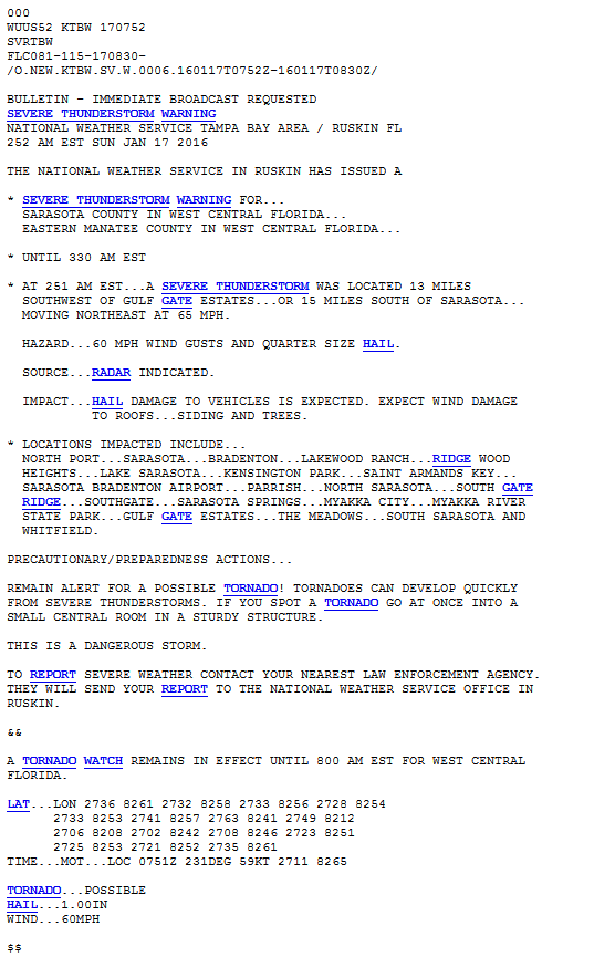
Severe Thunderstorm Warning (SVRTBW): 252 AM EST January 17th, 2016
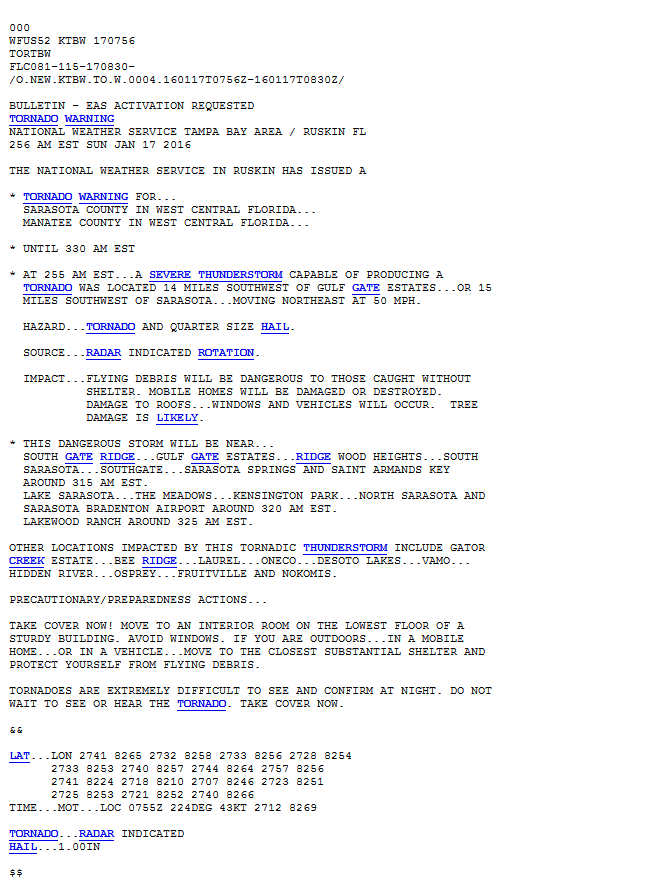
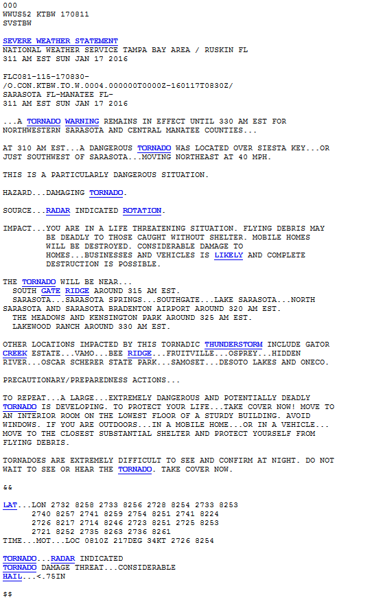
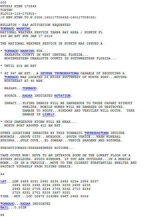
Tornado Warning (TORTBW): 256 AM EST January 17th, 2016
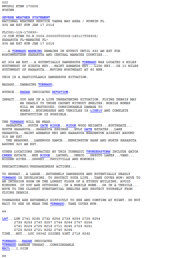
Tornado Warning Update #1 (SVSTBW): 305 AM EST January 17th, 2016
Tornado Warning Update #2 (SVSTBW): 311 AM EST January 17th, 2016
|
|
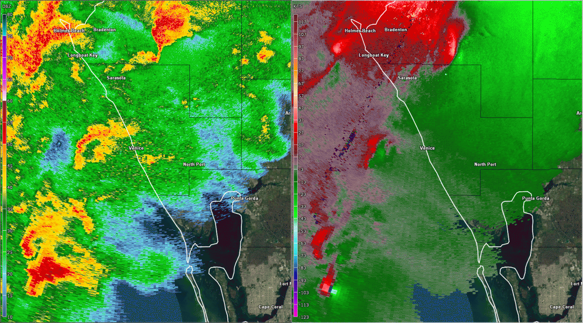
Sarasota / Siesta Key Supercell & Tornado Close up radar loop of the tornadic supercell that produced the first EF-2 tornado as it crosses the coast near Siesta Key in Sarasota County just after 3 AM EST on the 17th. |
What type of features are meteorologists looking for using doppler radar to detect potential tornadoes?
|
|
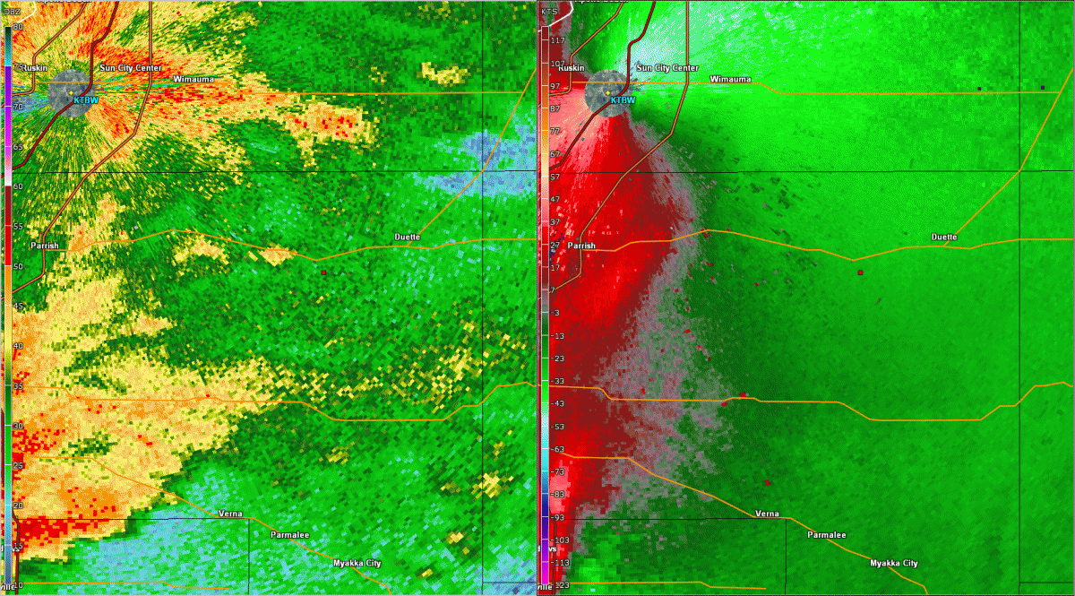
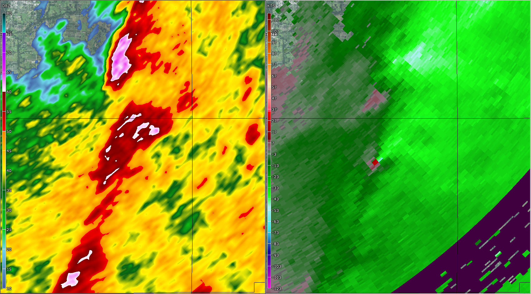
Doppler radar gives meteorologists a look at the winds inside a thunderstorm. The radar can detect the movement of raindrops, and determine not only if they are moving toward or away from the radar, but also the speed they are moving. This aspect of doppler radar allows meteorologists to infer rotation within a thunderstorm, how fast of rotation, and how compact the rotation is. To the left we see a classic doppler radar tornado signature moving ashore near Siesta Key. |
|
|
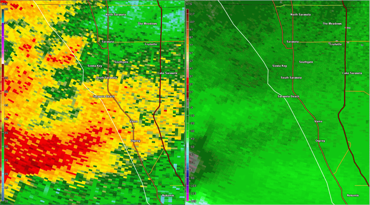
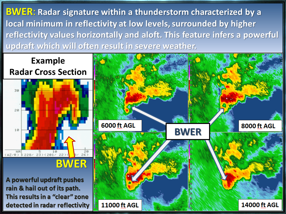
Sarasota Supercell & Tornado The supercell that impacted Sarasota County started well out over the eastern Gulf of Mexico. While crossing the coastal waters, a classic radar feature associated with severe weather, known as a “Bounded Weak Echo Region” (BWER), was detected. Here we see an explanation of the BWER phenomena using radar data from this supercell. |
Top
|
|
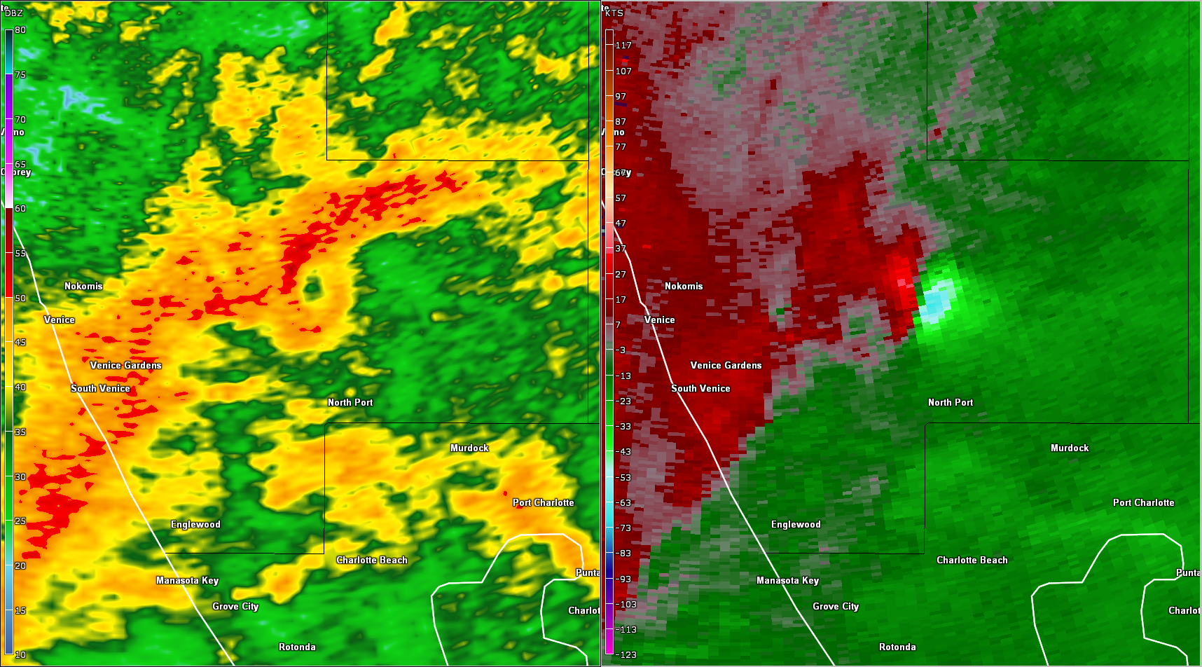
Duette / Manatee County Supercell & Tornado Radar loop of the second tornadic EF-2 tornado. This tornado came from the same parent supercell that spawned the Siesta Key tornado. After briefly weakening, the supercell produced this tornado over eastern Manatee County. |
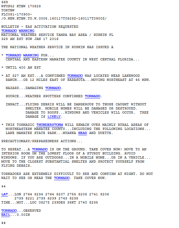
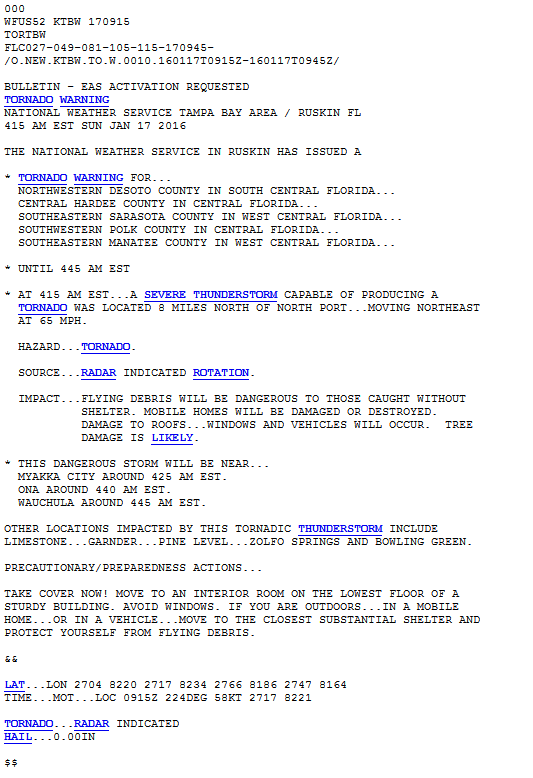
Tornado Warning (TORTBW): 328 AM EST January 17th, 2016
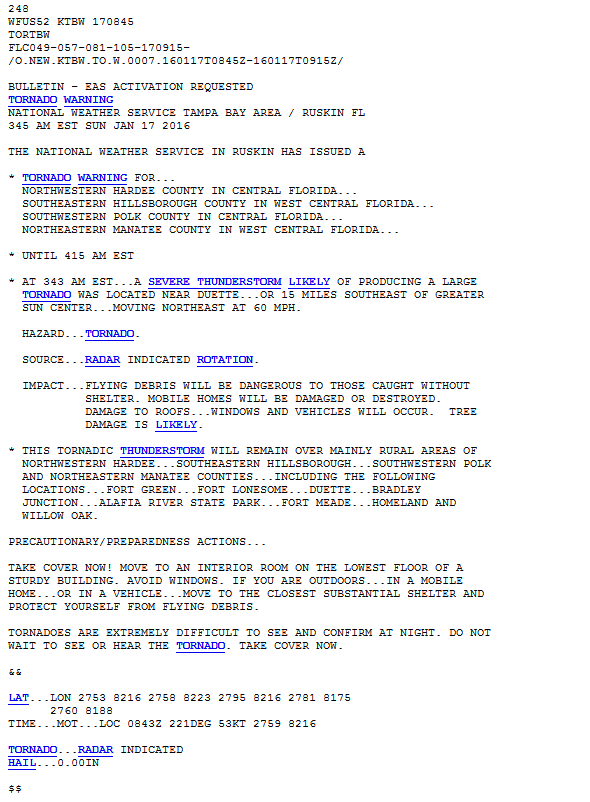
Tornado Warning (TORTBW): 345 AM EST January 17th, 2016
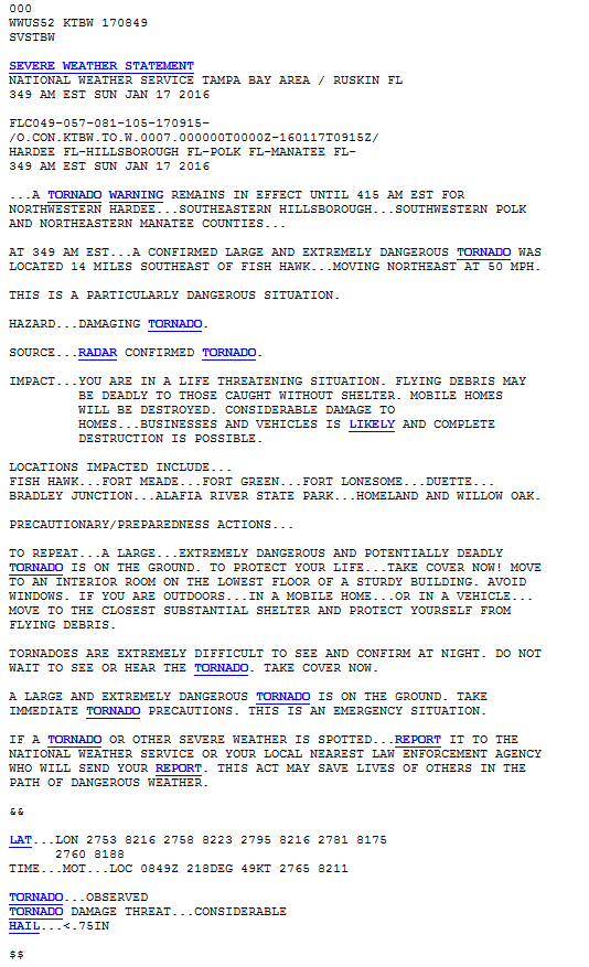
Tornado Warning Update #1 (SVSTBW): 349 AM EST January 17th, 2016
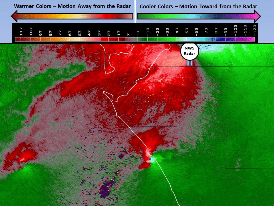
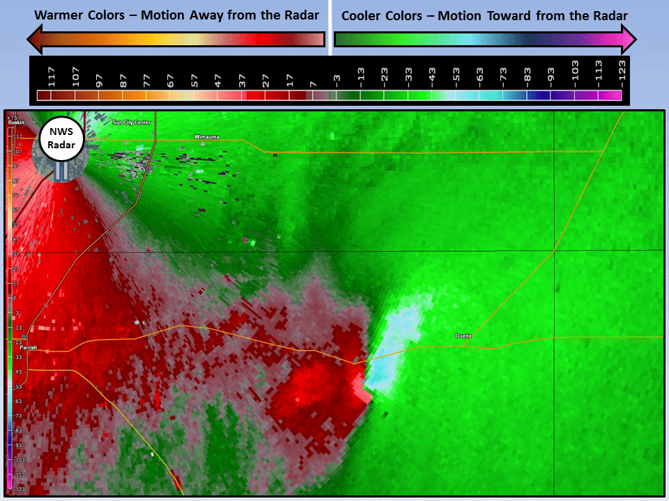
More examples of features meteorologists are looking for using doppler radar to detect potential tornadoes. These images come from the EF-2 tornado that impacted Manatee County near the town of Duette.
|
|
|
|
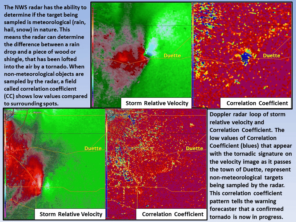
With Dual-polarization radar, the type of objects being detected by radar can be determined. The radar can tell meteorologists if the object is meteorological in nature (rain, hail, snow), or non-meteorological (dirt, wood, metal, etc). When non-meteorological objects are sampled, coincident with a tornadic velocity signature, it often confirms that a tornado is now on the ground, lofting the objects into the air. |
Top
|
|
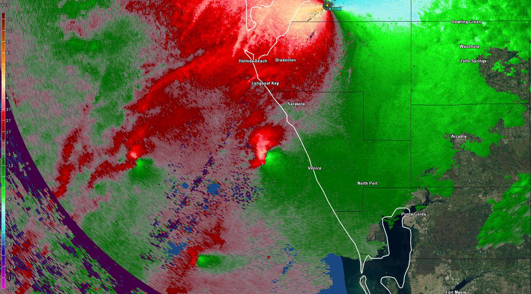
Another potentially tornadic supercell approached the coast of northwest Charlotte and southern Sarasota county between 3 AM EST and 4 AM EST on the 17th of January. The strong rotation within this supercell briefly weakened before crossing the coast around 4 AM EST, but increased once again over southern Sarasota county around 415 AM EST, before merging with the main line of thunderstorms and dissipating. |
Tornado Warning (TORTBW): 349 AM EST January 17th, 2016
Tornado Warning (TORTBW): 415 AM EST January 17th, 2016
|
|
The potentially tornadic supercell that crossed southern Sarasota county after 4 AM EST on the 17th of January, produced another defined Bounded Weak Echo Region (BWER) on radar reflectivity as the rotation in the thunderstorm strengthened once again around 415 AM EST. |
|
|
Warning operations became very busy early on the 17th. As Severe thunderstorm and tornado warnings went out for the dangerous supercell approaching Sarasota / Siesta Key, radar began to show multiple other rotating supercells following quickly behind the first thunderstorm. The southern storm in this image eventually required a tornado warning for Sarasota county, as it crossed the coast only a few miles south of the first Siesta Key tornado. |
|
|
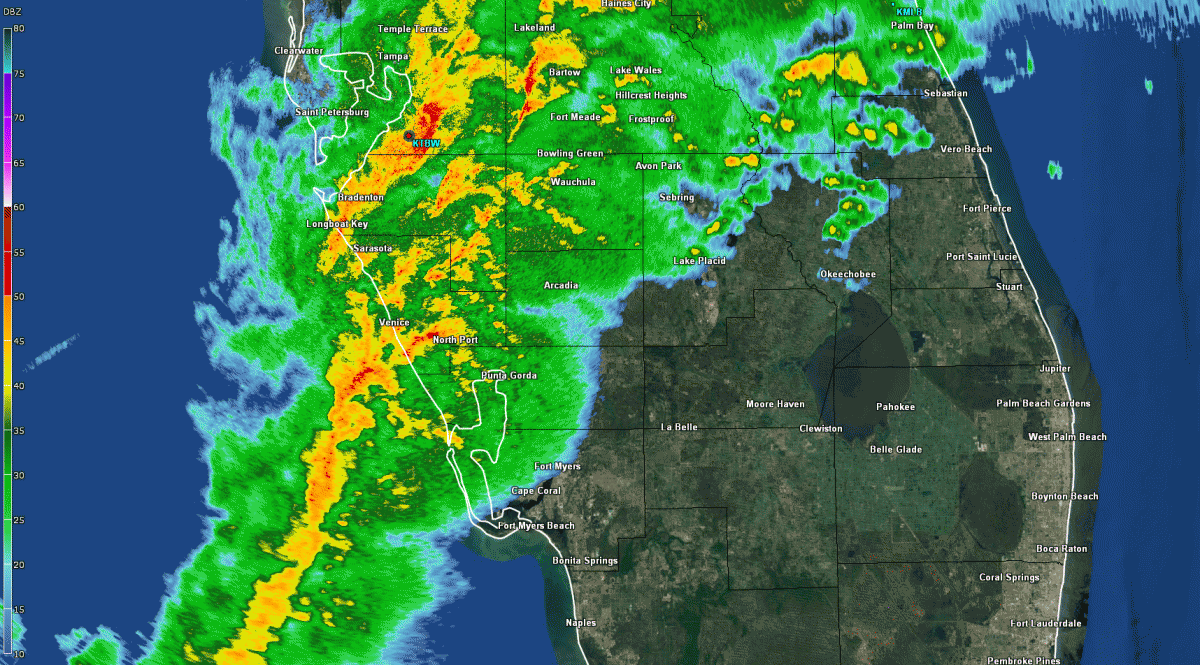
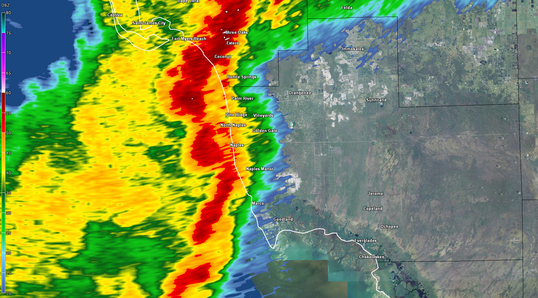
Eventually the storms consolidated into a squall line of embedded severe thunderstorms that moved eastward across areas to the south of the I-4 corridor. Wind gusts were measured at nearly 60 mph around Charlotte Harbor, and over 80 mph at Naples. The fast movement of the system allowed the squall line to exit into southeastern portions of the state before sunrise on the 17th. |
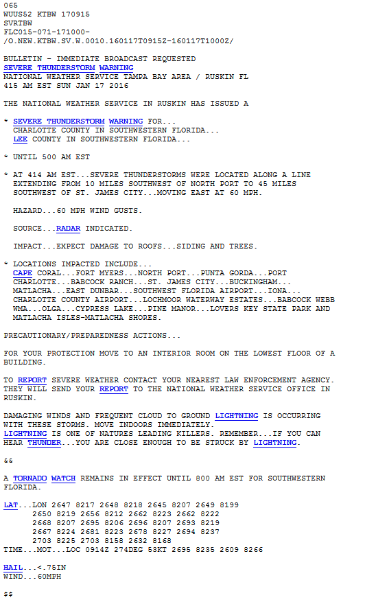
Severe Thunderstorm Warning (SVRTBW): 415 AM EST January 17th, 2016
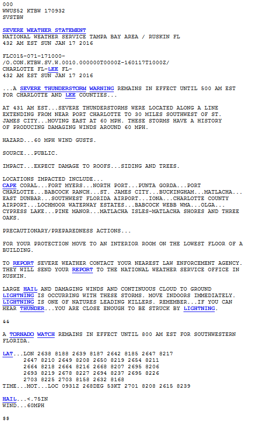
Severe Thunderstorm Warning Update #1 (SVSTBW): 432 AM EST January 17th, 2016
|
|
Several potential brief tornadoes were detected within this squall line as it moves across the southern half of the state. Here we see a small but strong couplet of rotation (circled right) over eastern Charlotte County around 5 AM on the 17th. The reflectivity image (left) shows what might be a small “hook echo” feature. Tornadoes embedded within squall lines, although usually smaller and of shorter duration than those associated with supercell thunderstorms, are still potentially very dangerous. |
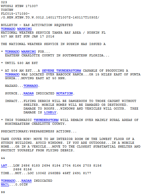
Tornado Warning (TORTBW): 507 AM EST January 17th, 2016
|
|
As the squall line moved into the southwest Florida coast, a bowing segment within the line (arrow to the left) passed over the Naples area. Bowing segments within squall lines are often associated with an enhanced threat for damaging winds. In this case a wind gust was measured at the Naples airport of over 80 mph! |


 Follow us on YouTube