
Potential Tropical Cyclone Nine is forecast to intensify and be near hurricane strength Wednesday in the far northwestern Caribbean Sea. It is expected to intensify into a major hurricane before it approaches the northeastern Gulf Coast on Thursday. Areas along the Florida Panhandle and the Florida west Gulf Coast should monitor the National Hurricane Center for the latest forecast updates. Read More >
Fire Weather Forecast:
|
282 FNUS55 KTFX 240921 FWFTFX Fire Weather Planning Forecast for North-Central Montana National Weather Service Great Falls MT 321 AM MDT Tue Sep 24 2024 .DISCUSSION... ...HIGH WIND WATCH IN EFFECT FROM WEDNESDAY EVENING THROUGH THURSDAY AFTERNOON FOR MUCH OF ZONE 112, 114, AND THE FAR NORTHERN PORTION OF ZONE 116... Upper level ridging will bring summer-like warmth and dry conditions for the next couple of days. Thermal belts will degrade overnight humidity recovery some each night, especially at the mid- slopes. Southwesterly winds increase Wednesday afternoon before a Pacific cold front brings periods of stronger winds Wednesday night into Thursday. MTZ112-242230- Eastern Glacier/Toole/Central/Eastern Pondera/Liberty- 321 AM MDT Tue Sep 24 2024 .TODAY... * Sky/Weather...........Sunny. * Max Temperature.......77-84...69-75 higher elevations. 24 hr trend......10 degrees up. * Min Humidity..........30-37 percent. 24 hr trend......Unchanged. * Wind (20 FT). Lower Elevations...Southwest winds 15 to 20 mph. Ridges.............Windy. Southwest winds around 25 mph decreasing to 15 to 20 mph in the afternoon. * LAL...................1. * CWR...................0 percent. * High Level Haines.....3 very low. .TONIGHT... * Sky/Weather...........Partly cloudy. * Min Temperature.......48-55. 24 hr trend......3 degrees up. * Max Humidity..........71-81 percent...58-68 percent higher elevations. 24 hr trend......2 percent up. * Wind (20 FT). Lower Elevations...Southwest winds 15 to 20 mph. Ridges.............Southwest winds 15 to 20 mph. * LAL...................1. * CWR...................0 percent. .WEDNESDAY... * Sky/Weather...........Mostly sunny. * Max Temperature.......80-88...72-79 higher elevations. 24 hr trend......3 degrees up. * Min Humidity..........23-29 percent. 24 hr trend......9 percent down. * Wind (20 FT). Lower Elevations...Southwest winds 15 to 20 mph. Ridges.............Southwest winds 15 to 20 mph. * LAL...................1. * CWR...................0 percent. * High Level Haines.....3 very low. .FORECAST DAYS 3 THROUGH 7...... .THURSDAY...Cooler. Very windy. Partly cloudy. Chance of showers. Lows in the lower 50s. Highs in the upper 60s. West winds around 40 mph. .FRIDAY...Windy. Mostly clear. Lows in the upper 40s. Highs in the mid 70s. Southwest winds around 30 mph. .SATURDAY...Mostly clear. Lows in the mid 40s. Highs around 70. West winds 15 to 20 mph. .SUNDAY...Partly cloudy. Slight chance of showers. Lows in the lower 40s. Highs in the lower 60s. .MONDAY...Partly cloudy. Slight chance of showers. Lows in the mid 30s. Highs in the upper 50s. $$ MTZ113-242230- Hill and Blaine Counties- 321 AM MDT Tue Sep 24 2024 .TODAY... * Sky/Weather...........Sunny. * Max Temperature.......77-82...70-75 higher elevations. 24 hr trend......8 degrees up. * Min Humidity..........35-41 percent. 24 hr trend......3 percent up...7 percent down higher elevations. * Wind (20 FT). Lower Elevations...Southwest winds 10 to 15 mph. Ridges.............Southwest winds 5 to 10 mph. * LAL...................1. * CWR...................0 percent. * High Level Haines.....2 very low (Above 3000 feet)...mid level haines 4 low (Below 3000 feet). .TONIGHT... * Sky/Weather...........Mostly clear. * Min Temperature.......48-56. 24 hr trend......1 degree up. * Max Humidity..........74-84 percent...64-74 percent higher elevations. 24 hr trend......13 percent down...4 percent down higher elevations. * Wind (20 FT). Lower Elevations...South winds 10 to 15 mph. Ridges.............South winds 10 to 15 mph. * LAL...................1. * CWR...................0 percent. .WEDNESDAY... * Sky/Weather...........Sunny. * Max Temperature.......84-90...77-82 higher elevations. 24 hr trend......7 degrees up. * Min Humidity..........26-34 percent. 24 hr trend......9 percent down. * Wind (20 FT). Lower Elevations...Southwest winds 10 to 15 mph. Ridges.............Southwest winds 10 to 15 mph. * LAL...................1. * CWR...................0 percent. * High Level Haines.....4 low (Above 3000 feet)...mid level haines 6 high (Below 3000 feet). .FORECAST DAYS 3 THROUGH 7...... .THURSDAY...Not as warm. Windy. Partly cloudy. Lows in the mid 50s. Highs in the lower 70s. Southwest winds around 25 mph. .FRIDAY...Clear. Lows in the upper 40s. Highs in the upper 70s. Southwest winds 15 to 20 mph. .SATURDAY...Mostly clear. Lows in the mid 40s. Highs in the mid 70s. West winds 10 to 15 mph. .SUNDAY...Partly cloudy. Lows in the mid 40s. Highs in the upper 60s. .MONDAY...Partly cloudy. Slight chance of showers. Lows in the upper 30s. Highs around 60. $$ MTZ114-242230- Lewis and Clark National Forest Rocky Mountain District- Rocky Mountain Front- 321 AM MDT Tue Sep 24 2024 .TODAY... * Sky/Weather...........Sunny. * Max Temperature.......78-84...65-75 higher elevations. 24 hr trend......9 degrees up. * Min Humidity..........27-35 percent...34-44 percent higher elevations. 24 hr trend......1 percent up...8 percent down higher elevations. * Wind (20 FT). Lower Elevations...Southwest winds 15 to 20 mph. Ridges.............Southwest winds 15 to 20 mph. * LAL...................1. * CWR...................0 percent. * High Level Haines.....3 very low. .TONIGHT... * Sky/Weather...........Mostly clear. * Min Temperature.......49-56. 24 hr trend......Unchanged...7 degrees up higher elevations. * Max Humidity..........61-71 percent. 24 hr trend......12 percent down...20 percent down higher elevations. * Wind (20 FT). Lower Elevations...Southwest winds 10 to 15 mph. Ridges.............Southwest winds 10 to 15 mph. * LAL...................1. * CWR...................0 percent. .WEDNESDAY... * Sky/Weather...........Mostly sunny. * Max Temperature.......80-88...67-77 higher elevations. 24 hr trend......1 degree up. * Min Humidity..........21-31 percent. 24 hr trend......9 percent down. * Wind (20 FT). Lower Elevations...Southwest winds 15 to 20 mph. Ridges.............Southwest winds 15 to 20 mph. * LAL...................1. * CWR...................0 percent. * High Level Haines.....3 very low. .FORECAST DAYS 3 THROUGH 7...... .THURSDAY...Cooler. Strong winds. Partly cloudy. Chance of showers. Lows around 50. Highs in the mid 60s. West winds around 45 mph. .FRIDAY...Windy. Mostly clear. Lows in the upper 40s. Highs in the lower 70s. Southwest winds around 25 mph. .SATURDAY...Mostly clear. Lows in the mid 40s. Highs around 70. Southwest winds 20 to 25 mph. .SUNDAY...Partly cloudy. Slight chance of showers. Lows in the lower 40s. Highs in the lower 60s. .MONDAY...Partly cloudy. Slight chance of showers. Lows in the upper 30s. Highs in the upper 50s. $$ MTZ115-242230- Chouteau and Fergus Counties- 321 AM MDT Tue Sep 24 2024 .TODAY... * Sky/Weather...........Sunny. * Max Temperature.......78-83...71-77 higher elevations. 24 hr trend......8 degrees up. * Min Humidity..........32-40 percent. 24 hr trend......2 percent up. * Wind (20 FT). Lower Elevations...Southwest winds 10 to 15 mph. Ridges.............West winds 15 to 20 mph becoming southwest around 5 mph in the afternoon. * LAL...................1. * CWR...................0 percent. * High Level Haines.....3 very low (Above 3000 feet)...mid level haines 4 low (Below 3000 feet). .TONIGHT... * Sky/Weather...........Mostly clear. * Min Temperature.......50-58. 24 hr trend......6 degrees up. * Max Humidity..........66-76 percent...49-58 percent higher elevations. 24 hr trend......7 percent down...22 percent down higher elevations. * Wind (20 FT). Lower Elevations...South winds 10 to 15 mph. Ridges.............South winds 10 to 15 mph. * LAL...................1. * CWR...................0 percent. .WEDNESDAY... * Sky/Weather...........Sunny. * Max Temperature.......85-91...78-84 higher elevations. 24 hr trend......7 degrees up. * Min Humidity..........21-29 percent. 24 hr trend......12 percent down. * Wind (20 FT). Lower Elevations...Southwest winds 15 to 20 mph. Ridges.............Southwest winds 10 to 15 mph. * LAL...................1. * CWR...................0 percent. * High Level Haines.....4 low (Above 3000 feet)...mid level haines 5 moderate (Below 3000 feet). .FORECAST DAYS 3 THROUGH 7...... .THURSDAY...Not as warm. Mostly clear. Lows in the mid 50s. Highs in the mid 70s. West winds 20 to 25 mph. .FRIDAY...Clear. Lows in the upper 40s. Highs in the lower 80s. Southwest winds 15 to 20 mph. .SATURDAY...Mostly clear. Lows in the upper 40s. Highs in the mid 70s. Southwest winds 10 to 15 mph. .SUNDAY...Partly cloudy. Lows in the upper 40s. Highs in the upper 60s. .MONDAY...Partly cloudy. Slight chance of showers. Lows in the upper 30s. Highs around 60. $$ MTZ116-242230- Lincoln Ranger District of the Helena National Forest- 321 AM MDT Tue Sep 24 2024 .TODAY... * Sky/Weather...........Sunny. * Max Temperature.......74-79...66-74 higher elevations. 24 hr trend......10 degrees up. * Min Humidity..........34-42 percent. 24 hr trend......6 percent down. * Wind (20 FT). Lower Elevations...Southwest winds 10 to 15 mph. Ridges.............Southwest winds 10 to 15 mph. * LAL...................1. * CWR...................0 percent. * High Level Haines.....3 very low. .TONIGHT... * Sky/Weather...........Mostly clear. * Min Temperature.......46-54. 24 hr trend......8 degrees up. * Max Humidity..........67-77 percent...54-64 percent higher elevations. 24 hr trend......46 percent down...17 percent down higher elevations. * Wind (20 FT). Lower Elevations...Southwest winds 10 to 15 mph. Ridges.............Southwest winds 10 to 15 mph. * LAL...................1. * CWR...................0 percent. .WEDNESDAY... * Sky/Weather...........Sunny. * Max Temperature.......79-84...69-78 higher elevations. 24 hr trend......5 degrees up. * Min Humidity..........21-28 percent. 24 hr trend......11 percent down...16 percent down higher elevations. * Wind (20 FT). Lower Elevations...Southwest winds 10 to 15 mph. Ridges.............Southwest winds 10 to 15 mph. * LAL...................1. * CWR...................0 percent. * High Level Haines.....3 very low. .FORECAST DAYS 3 THROUGH 7...... .THURSDAY...Cooler, windy. Partly cloudy. Slight chance of showers. Lows in the mid 40s. Highs in the lower 60s. West winds around 30 mph. .FRIDAY...Mostly clear. Lows in the mid 40s. Highs in the upper 60s. Southwest winds 15 to 20 mph. .SATURDAY...Mostly clear. Lows in the mid 40s. Highs in the upper 60s. West winds 15 to 20 mph. .SUNDAY...Partly cloudy. Lows in the mid 40s. Highs in the lower 60s. .MONDAY...Partly cloudy. Lows in the upper 30s. Highs in the mid 50s. $$ MTZ117-242230- Central and Eastern Lewis and Clark National Forest Areas- 321 AM MDT Tue Sep 24 2024 .TODAY... * Sky/Weather...........Sunny. * Max Temperature.......75-84...67-76 higher elevations. 24 hr trend......13 degrees up. * Min Humidity..........30-39 percent. 24 hr trend......2 percent up. * Wind (20 FT). Lower Elevations...Southwest winds 15 to 20 mph. Ridges.............Southwest winds 15 to 20 mph. * LAL...................1. * CWR...................0 percent. * High Level Haines.....3 very low. .TONIGHT... * Sky/Weather...........Mostly clear. * Min Temperature.......48-58. 24 hr trend......3 degrees up...9 degrees up higher elevations. * Max Humidity..........56-66 percent. 24 hr trend......10 percent down...21 percent down higher elevations. * Wind (20 FT). Lower Elevations...South winds 15 to 20 mph. Ridges.............South winds 10 to 15 mph increasing to southwest 20 to 25 mph after midnight. * LAL...................1. * CWR...................0 percent. .WEDNESDAY... * Sky/Weather...........Sunny. * Max Temperature.......80-89...71-81 higher elevations. 24 hr trend......4 degrees up. * Min Humidity..........20-26 percent. 24 hr trend......11 percent down. * Wind (20 FT). Lower Elevations...Southwest winds 15 to 20 mph. Ridges.............Southwest winds 15 to 20 mph. * LAL...................1. * CWR...................0 percent. * High Level Haines.....4 low. .FORECAST DAYS 3 THROUGH 7...... .THURSDAY...Not as warm. Windy. Mostly clear. Lows in the lower 50s. Highs around 70. Southwest winds around 25 mph. .FRIDAY...Mostly clear. Lows in the upper 40s. Highs in the mid 70s. Southwest winds 15 to 20 mph. .SATURDAY...Mostly clear. Lows in the upper 40s. Highs in the lower 70s. Southwest winds 10 to 15 mph. .SUNDAY...Partly cloudy. Lows in the mid 40s. Highs in the upper 60s. .MONDAY...Cooler. Partly cloudy. Slight chance of showers. Lows in the upper 30s. Highs in the upper 50s. $$ MTZ118-242230- Helena and Townsend Ranger Districts of the Helena National Forest- 321 AM MDT Tue Sep 24 2024 .TODAY... * Sky/Weather...........Sunny. * Max Temperature.......74-81...65-74 higher elevations. 24 hr trend......7 degrees up. * Min Humidity..........32-40 percent. 24 hr trend......4 percent up...1 percent down higher elevations. * Wind (20 FT). Lower Elevations...South winds 15 to 20 mph. Ridges.............South winds 10 to 15 mph. * LAL...................1. * CWR...................0 percent. * High Level Haines.....3 very low. .TONIGHT... * Sky/Weather...........Mostly clear. * Min Temperature.......47-55. 24 hr trend......8 degrees up. * Max Humidity..........64-74 percent...51-59 percent higher elevations. 24 hr trend......13 percent down...21 percent down higher elevations. * Wind (20 FT). Lower Elevations...South winds 15 to 20 mph. Ridges.............South winds 10 to 15 mph increasing to 20 to 25 mph after midnight. * LAL...................1. * CWR...................0 percent. .WEDNESDAY... * Sky/Weather...........Sunny. * Max Temperature.......79-87...70-79 higher elevations. 24 hr trend......7 degrees up. * Min Humidity..........20-26 percent. 24 hr trend......13 percent down. * Wind (20 FT). Lower Elevations...South winds 15 to 20 mph. Ridges.............South winds 15 to 20 mph. * LAL...................1. * CWR...................0 percent. * High Level Haines.....4 low. .FORECAST DAYS 3 THROUGH 7...... .THURSDAY...Windy. Mostly clear. Lows in the lower 50s. Highs in the lower 70s. Southwest winds around 30 mph. .FRIDAY...Clear. Lows in the upper 40s. Highs in the mid 70s. Southwest winds 15 to 20 mph. .SATURDAY...Mostly clear. Lows in the upper 40s. Highs in the lower 70s. South winds 10 to 15 mph. .SUNDAY...Partly cloudy. Lows in the upper 40s. Highs in the upper 60s. .MONDAY...Cooler. Partly cloudy. Slight chance of showers. Lows in the upper 30s. Highs in the upper 50s. $$ weather.gov/greatfalls |
 |
 |
 |
| Fire Weather Risk - Day 1 Click to Enlarge |
Fire Weather Risk - Day 2 Click to Enlarge |
Fire Weather Risk - Day 3 Click to Enlarge |
|
Enhanced Hazardous Weather Outlook
GFDI images through Day 7 can be found in the "Hazards" Tab. Click here for a detailed breakdown of all mentioned hazards. |
Note: The table and site above are an experimental product to support preparedness and response efforts prior to and during hazardous weather. Users should use in conjunction with checking the latest forecast and, if needed, consulting with a meteorologist. Feedback is always welcomed on this or any product.
Current Hazards- Click On Right Menu For More Options Temperature | Relative Humidity | Wind | Precipitation Temperature |​ Relative Humidity | Wind | Precipitation Temperature |​ Relative Humidity | Wind | Precipitation Today's Liquid Precipitation Forecast Click to Enlarge Tomorrow's Liquid Precipitation Forecast Click to Enlarge
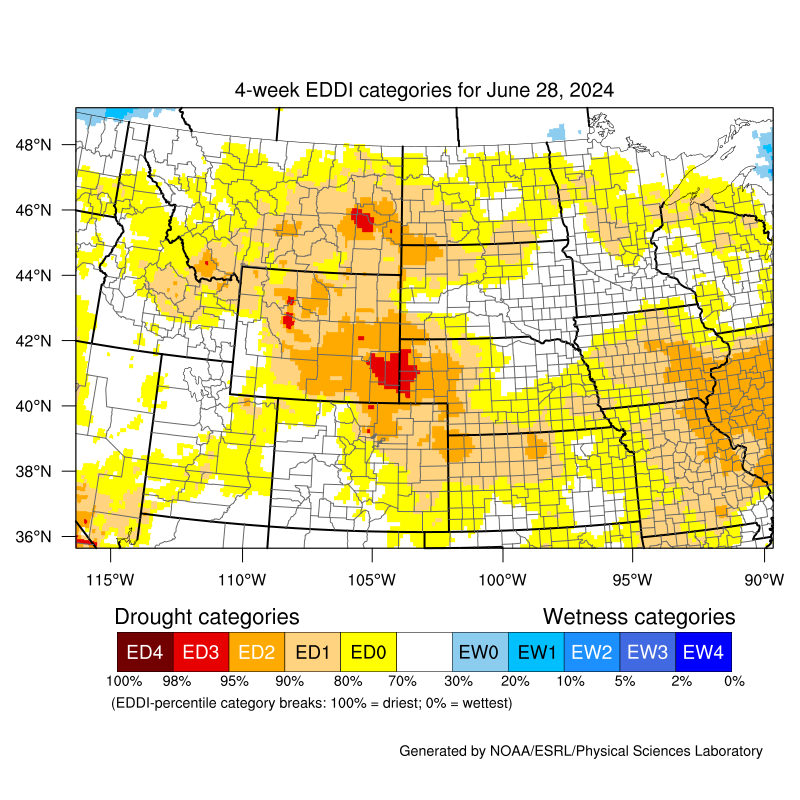
Open the mobile friendly version here: https://m.wfas.net SPC Fire Weather Outlooks Climate Prediction Center (CPC) 6-10 Day Temperature Outlook Click to Enlarge Climate Prediction Center (CPC) 6-10 Day Precipitation Outlook Click to Enlarge Climate Prediction Center (CPC) 8-14 Day Temperature Outlook Click to Enlarge Climate Prediction Center (CPC) 8-14 Day Precipitation Outlook Click to Enlarge Latest U.S. Drought Monitor for Montana Click to Enlarge Latest U.S. Drought Monitor 12 Week Loop Click to Enlarge Latest 4-week Evaporative Demand Drought Index (EDDI) Click to Enlarge Contact: For questions, comments, or additional information please contact us anytime at 1-406-952-3790 *. You can also find us on Facebook, Twitter, and YouTube. *Note: Phone number above is not for public dissemination. Please refer the public calls to 1-406-453-2081. Social Media
Hazards
Thunderstorms
Weather Forecast
Area Forecast Discussion
Outlooks
Contact Us
Day 1 Fire Weather Risk
Click to EnlargeDay 2 Fire Weather Risk
Click to EnlargeDay 3 Fire Weather Risk
Click to Enlarge


Day 4 Fire Weather Risk
Click to EnlargeDay 5 Fire Weather Risk
Click to EnlargeDay 6 Fire Weather Risk
Click to Enlarge

Day 7 Fire Weather Risk
Click to Enlarge


SPC Day 1 Convective Outlook
Click to EnlargeSPC Day 2 Convective Outlook
Click to EnlargeSPC Day 3 Convective Outlook
Click to Enlarge


Day 1 Forecast High Temperatures
Click to EnlargeDay 2 Forecast High Temperatures
Click to EnlargeDay 3 Forecast High Temperatures
Click to Enlarge


Day 1 Forecast Low Temperatures
Click to EnlargeDay 2 Forecast Low Temperatures
Click to EnlargeDay 3 Forecast Low Temperatures
Click to Enlarge


Day 1 Forecast Minimum Relative Humidity (RH)
Click to EnlargeDay 2 Forecast Minimum Relative Humidity (RH)
Click to EnlargeDay 3 Forecast Minimum Relative Humidity (RH)
Click to Enlarge


Day 1 Forecast Maximum Relative Humidity (RH)
Click to EnlargeDay 2 Forecast Maximum Relative Humidity (RH)
Click to EnlargeDay 3 Forecast Maximum Relative Humidity (RH)
Click to Enlarge


Wind forecast for the next 3 hours
Click to EnlargeWind forecast for the next 3-6 hours
Click to EnlargeWind forecast for the next 6-9 hours
Click to Enlarge


Wind forecast for the next 9-12 hours
Click to EnlargeWind forecast for the next 12-15 hours
Click to EnlargeWind forecast for the next 15-18 hours
Click to Enlarge


Wind forecast for the next 18-21 hours
Click to EnlargeWind forecast for the next 21-24 hours
Click to EnlargeWind forecast for the next 24-27 hours
Click to Enlarge

Peak Winds over the next 3 Days
Click to Enlarge


NWS 3 Day Precipitation Forecast
Click to EnlargeWPC 5 Day Precipitation Forecast
Click to EnlargeWPC 7 Day Precipitation Forecast
Click to Enlarge

NWS 3 Day Snow Forecast
Click to Enlarge
137
FXUS65 KTFX 241417
AFDTFX
Area Forecast Discussion
National Weather Service Great Falls MT
817 AM MDT Tue Sep 24 2024
.SYNOPSIS...
Much warmer and dry conditions are expected for the next couple
of days before a fast moving weather system brings periods of
breezy to windy conditions, a few showers or storms, and cooler
temperatures to close out the week.
&&
.UPDATE...
Winds this morning were coming in a little higher than previously
forecasted so some adjustments were made using the latest model
guidance to better fit what is expected through the rest of today.
Otherwise the going forecast remains on track. -thor
&&
.AVIATION...
24/12Z TAF Period
VFR conditions will continue through at least 25/12Z across North
Central (KCTB, KHVR), Central (KLWT, KGTF, KHLN), and Southwest
(KBZN, KEKS, KWYS) Montana.
High pressure aloft will only allow a few high clouds to pass
overhead. Breezy west to southwest surface winds will shift more
southerly after 18Z; occasional gusts will mostly stay between 20
and 30 kt. -Coulston
Refer to weather.gov/zlc for more detailed regional aviation
weather and hazard information.
&&
.PREV DISCUSSION...
/ISSUED 442 AM MDT Tue Sep 24 2024/
High pressure builds in for the next couple of days for a return
of well above average temperatures and dry conditions. Expect
afternoon highs to warm into the 80s for most lower elevation
locations today, with the warmest areas making a run for 90 on
Wednesday.
A trough moves onto the Pacific NW coast and displaces the upper
level ridge in favor of a southwesterly flow aloft by late
Wednesday. This will increase west to southwesterly surfaces
winds, though the strongest winds look to hold off until Wednesday
night and Thursday when the trough ejects eastward and sends a
Pacific cold front racing through the CWA.
Isolated shower activity, mountain wave activity, and the
transfer momentum of the front itself looks to help mix 40 to 50
kt H500/H700 winds to the surface along the Rocky Mountain Front
and adjacent plains Wednesday night. This will be followed by the
maintenance of the windier conditions into Thursday thanks to deep
layer mixing and cold air advection.
Current probabilistic guidance for wind gusts in excess of 55 mph
are running over 50% for locations along the Rocky Mountain Front
eastward onto the northern high plains near the Cut Bank area.
These chances fall well below 30% for other areas, but there are
typically some concerns for stronger bursts of winds along the Hi-
Line in this type of set up as well.
Given the aforementioned factors, a High Wind Watch was issued
for the Rocky Mountain Front, their adjacent high plains zones,
and the eastern Toole and Liberty zone. Timing of the cold front
Wednesday night and the overall strongest mixing winds on Thursday
still needs to be fine tuned, but going with 26/03Z (9 pm Wed) to
26/21Z (3 pm Thurs) run time seems reasonable for now.
A stronger west to southwesterly flow aloft continues through at
least the first half of the weekend for more breezy to windy
conditions and above normal temperatures. probabilities for
sustained winds/gusts exceeding 40 mph/55 mph remain low, but
those with outdoor recreation plans should still expect windy
conditions along the Rocky Mountain Front.
Forecast certainty is still a bit murky for the weekend, though
more ensembles are now favoring the passage of an open wave and
attendant cold front sometime between the late Saturday and Monday
timeframe. While there are still differences among ensemble
members, most yield temperatures cooling closer to average and
slight chances for precipitation. - RCG
&&
.PRELIMINARY POINT TEMPS/POPS...
GTF 83 55 88 53 / 0 0 0 0
CTB 82 49 85 51 / 0 0 0 20
HLN 83 52 89 53 / 0 0 0 0
BZN 80 47 87 48 / 0 0 0 0
WYS 73 35 75 36 / 0 0 0 0
DLN 78 47 83 47 / 0 0 0 0
HVR 82 51 89 54 / 0 0 0 0
LWT 78 53 85 52 / 0 0 0 0
&&
.TFX WATCHES/WARNINGS/ADVISORIES...
High Wind Watch from Wednesday evening through Thursday
afternoon for East Glacier Park Region-Eastern Glacier, Western
Toole, and Central Pondera-Eastern Toole and Liberty-Northern
High Plains-Southern High Plains-Southern Rocky Mountain Front.
&&
$$
http://www.weather.gov/greatfalls
Day 1
Day 2


Northern Rockies Area Fire Weather Outlook - Day 1
Click to EnlargeNorthern Rockies Area Fire Weather Outlook - Day 2
Click to EnlargeNorthern Rockies Area Fire Weather Outlook - Day 3
Click to Enlarge


MT Percent of Average Precipitation (%) - 7 Day
Click to EnlargeMT Percent of Average Precipitation (%) - 14 Day
Click to EnlargeMT Percent of Average Precipitation (%) - 30 Day
Click to Enlarge


Tweets by @NWSGreatFalls
#mtwx Tweets
 |
 |
 |
 |
|
Missoula Radar Loop Click to Enlarge |
Great Falls Radar Loop Click to Enlarge |
Billings Radar Loop Click to Enlarge |
Glasgow Radar Loop Click to Enlarge |
 |
 |
 |
 |
|
Regional Radar Loop Click to Enlarge |
Visible Satellite |
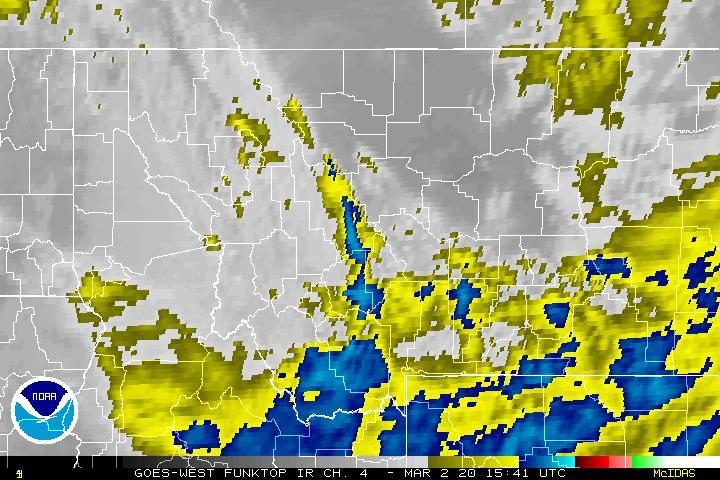
Infrared Satellite Click to Enlarge |
Water Vapor Satellite Click to Enlarge |


 Great Falls Radar
 Satellite
 Current Observations
 Forecast Discussion
 Montana Weather
 Fire Weather
 Winter Weather Forecasts
 Transportation Forecasts
 Weather Prediction Center
 Storm Prediction Center
 Aviation Weather