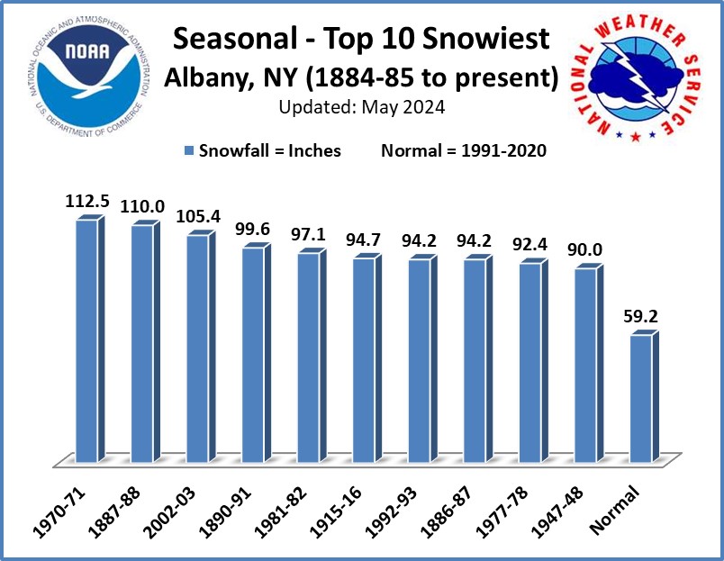
This storm stands as the 3rd greatest snowstorm for December and is one of the greatest ever for Albany. The winter of 1887-88 is the 2nd snowiest on record for Albany with 110.0 inches.
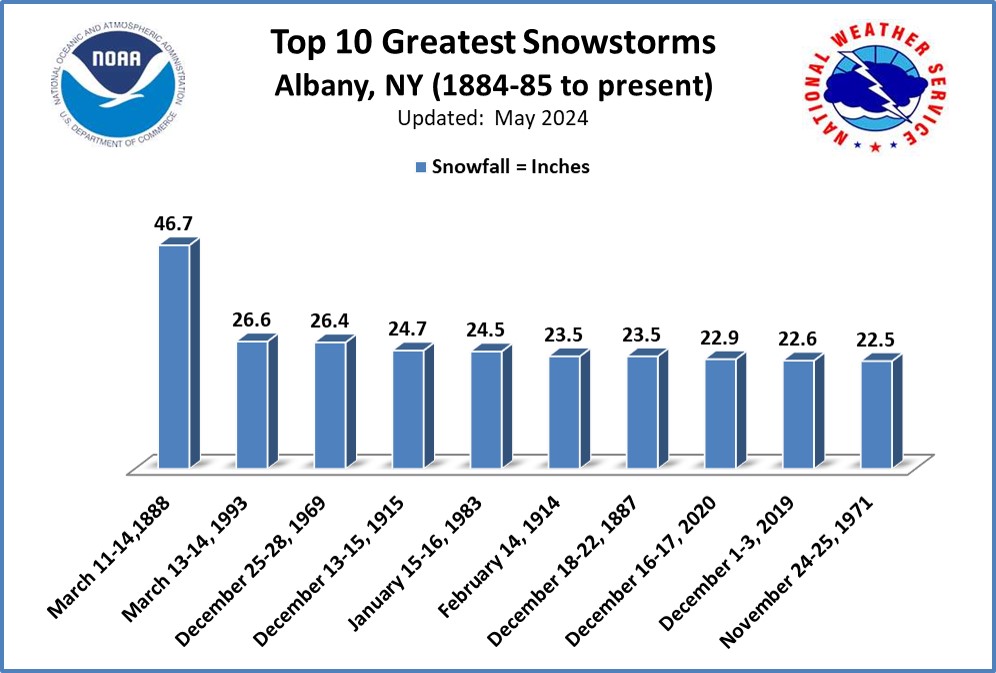
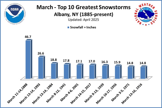
The blizzard by which all others are measured. Light snow began around 3 PM on Sunday the 11th, accumulating to near 3 inches by midnight. The snow intensified overnight and there was 18 inches on the ground by daybreak on Monday the 12th. Moderate to heavy snow continued throughout the day accumulating to 33 inches by midnight. Snow continued on and off through Tuesday the 13th, adding roughly another foot, until finally ending around 3 AM on the 14th. Total snowfall for the storm was 46.7 inches, but the drifts were significantly higher. This storm stills holds the record snowfall for a storm for Albany. March 1888 stands as the 2nd snowiest month on record for Albany. The winter of 1886-87 is the snowiest on record for Albany with 94.2 inches.
The city of Albany was virtually shut down. There were no coal deliveries, and thus, no heat. Doctors were unable to make house calls, and it took many days to clear the snow off of country roads to make them passable. At the time it was called the "worst storm in living memory," and it still holds the distinction of the worst winter storm on record in many areas of the northeast.
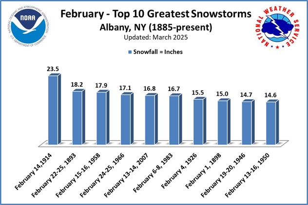
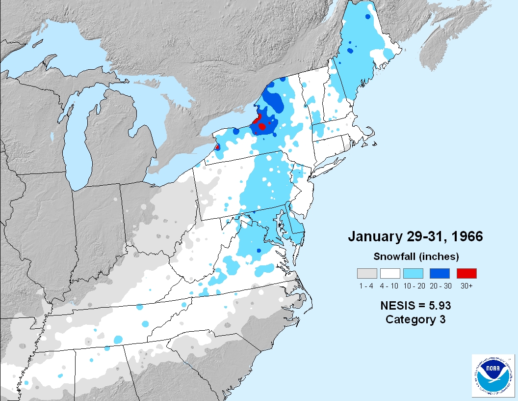
Very cold and windy with blizzard conditions. To the south of Albany 10 to 20 inches of snow fell with 20 to more than 30 inches accumualated across portions of eastern and central New York. In Albany 23.5 inches fell. This storm stands as the greatest snowstorm for February and one of the greatest ever for Albany.
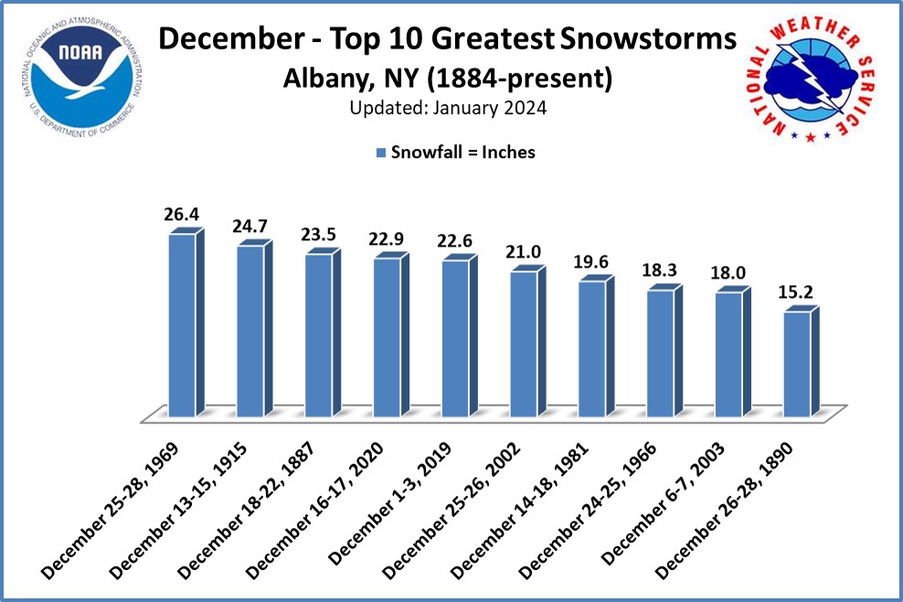
Twenty-five to 35 inches of snow fell across eastern and southeastern New York. In Albany 24.7 inches of snow was measured. This storm stands as the 2nd greatest snowstorm for December and 4th greatest ever for Albany. The winter of 1915-16 is one of the snowiest on record for Albany with 94.7 inches.
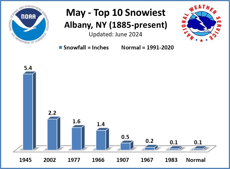
Many areas across the region saw snow accumulation. The 5.4 inches of snow recorded at Albany, made it the largest May snowstorm to date. 60,000 power outages were reported across the Capital District of NY from downed trees and wires. Some locations were without power for a few days. Largest number of power outages since ice storm of 1929. In the City of Albany alone, 10 DPW trucks were assigned to debris removal. Glens Falls reported 3 inches of snow. Locations in Western New England reported 3 to 8 inches of snow. In the hill towns, snowplows had to rescue stranded motorists.
A storm rapidly deepened as it tracked inland along the eastern slopes of the Appalachians. The rain and snow associated with the storm was not that great, but the winds were a different story. The storm was situated between two very strong high pressure centers, one east of Labrador and another over the Mississippi Valley, producing a very tight pressure gradient. A wind gust of 83 mph was recorded at Albany, the strongest ever, with sustained winds of 50 to 60 mph. Roads were impassable to fallen trees, fire towers, telephone and power lines were blown down across the region, and wind damage was extensive in New York State, totaling 20 million dollars at the time. Rain and snow fell across the region. Some places across southwestern New York received 20+ inches of snowfall. No snow fell in Albany however 1.08 inches of rain was reported with 7.78 inches of rainfall at Slide Mountain in the Catskills.
A coastal storm brought strong winds and heavy snow to the northeast. Over 30 inches of snow was reported across the Catskills and in western New England, with 17.9 inches at Albany. Travel of any sort became impossible, and drifting of the snow blocked most roads and highways and marooning many. Operation "Haylift" was instituted, where helicopters dropped food for stranded cattle.
Widespread 10 to 15 inches of snow across Albany Forecast Area, with up to 30 inches in Catskills, and around 20 inches in southern Vermont and the Berkshires. 15.4 inches reported at Albany, NY making it one of the top 10 greatest snowstorms from January. Winds gusting 50 to 60 MPH caused near zero visibility and snow drifts of 3 to 8 feet were reported. Route 9 in Vermont was closed from Bennington to Brattleboro. Winds downed trees and powerlines in Massachusetts causing power outages.
Freezing rain caused ice accumulations of up to 1.5 inches and crippled east central New York. Many residents were without power for up to two weeks and schools had to be shut down for a week. Damage was estimates approached 5 million dollars. Temporary shelters were opened in Massachusetts and New York. Thawing of ice on December 11 caused additional power outages as wires snapped from sudden release of weight. Icing conditions extended from Buffalo to Boston. Worst glazing since December 29-30, 1942. During storm, precipitation was mostly snow in southern Vermont (6-10” reported) and plain rain in northwest Connecticut.
Intense coastal storm followed by heavy lake effect snows/squalls. This storm is not so much known for it's blizzard conditions, which produced a foot of snow at Albany on the 29th and 30th, but for the intense lake squalls that developed as arctic air streamed across Lake Ontario on the 30th and 31st. Oswego reported 75 inches inches, with some unofficial reports of around 100 inches in that vicinity. Rome, which is approximately 75 miles from Lake Ontario, received 41 inches. NESIS: Category 3 - Major.
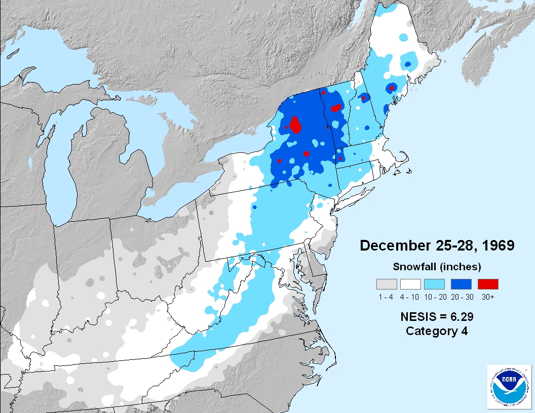
A foot of snow had already fallen on December 22nd, 1969, but this was outdone by another storm system which began moving northward along the east coast Christmas night. On the morning of the 27th, with 15 inches already on the ground at Albany, the storm stalled off the New England coast. It then began to move inland for a short period before heading back out to sea on the 28th. A total of 26.7 inches of snow fell at Albany, making it the greatest snowstorm for December and the 3rd greatest stormsnow on record. However, Vermont surpassed that, with 30 inches at Burlington and 44inches at Waitsfield, southwest of Montpelier. In and around the Capital District, it was a heavy, wet snowfall, and the snow mixed with freezing rain at times. Snow removal became quite difficult, and some streets were not cleared for 3-4 weeks. The city of Albany public works continued round the clock snow removal for over a month before things returned near normal. Two million dollars were spent on snow removal, a record at the time. December 1969 stands as the snowiest month on record for Albany. In addition, a record low temperature was set in Albany on December 25th, 1969: -22 degrees. NESIS: Category 4 - Crippling.
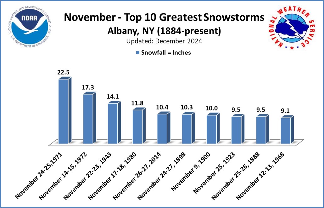
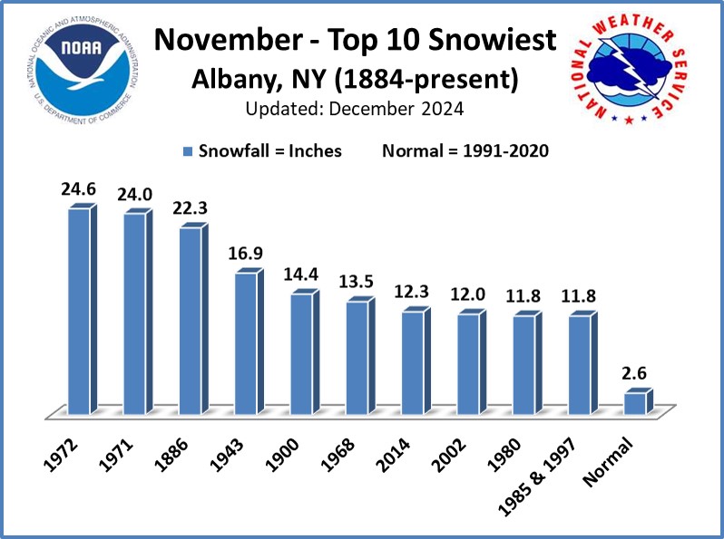
Heavy snow in Catskills and acorss the Upper Hudson Valley. This heavy snow began on the day before Thanksgiving and continued into Thanksgiving day. Albany picked up 22.5 inches with amounts up to 30" reported elsewhere. This storm turned the busiest travel day of the year into a nightmare, with many stranded travelers not making it to their destinations on Thanksgiving. This storm was the greatest November snowstorms on record and one of the greatest ever,
At Albany, NY, the temperature fell from 41°F at midnight, to 1°F at 10:30 AM, with a 30 degree drop in the few hours before sunrise. Rain changed to snow and winds at Albany increased to 50 MPH with gusts to 67 MPH. Officially, only 3” of snow was measured at Albany, but visibility was near zero during morning commute. Roads were very icy and travel was seriously hampered. Two fatalities were reported; a man died from exposure to cold and another man was blown off a tug boat into the Hudson River and drowned. Winds downed trees and powerlines and caused some power outages and isolated structural damage. Brief blizzard conditions occurred across New York State with blizzard conditions reported in Buffalo and New York City. A long stretch of the NYS Thruway was closed. Strong northwest winds also caused a record low tide in New York Harbor.
This storm is more well known for its impact on coastal New England and Long Island, but it still had quite an impact on eastern New York and western New England. The Green Mountains of Vermont were hit hard, with many areas reporting around two feet of snow. East Wallingford, near Rutland had 30 inches. The Catskills also had quite a bit, with Prattsville reporting 25 inches. Albany receivced 13.4 inches of snow. Wind also caused quite a bit of drifting of the snow. On the coast, Boston received 26.7 inches of snow. The storm also produced strong winds, Logan Airport reported an 83 mph gust and there was a report of 92 mph on Cape Cod. The winter of 1977-78 is one of the snowiest on record for Albany with 92.4 inches. NESIS: Category 3 - Major.
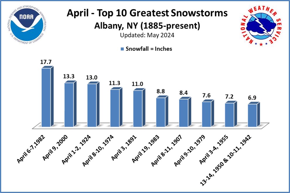
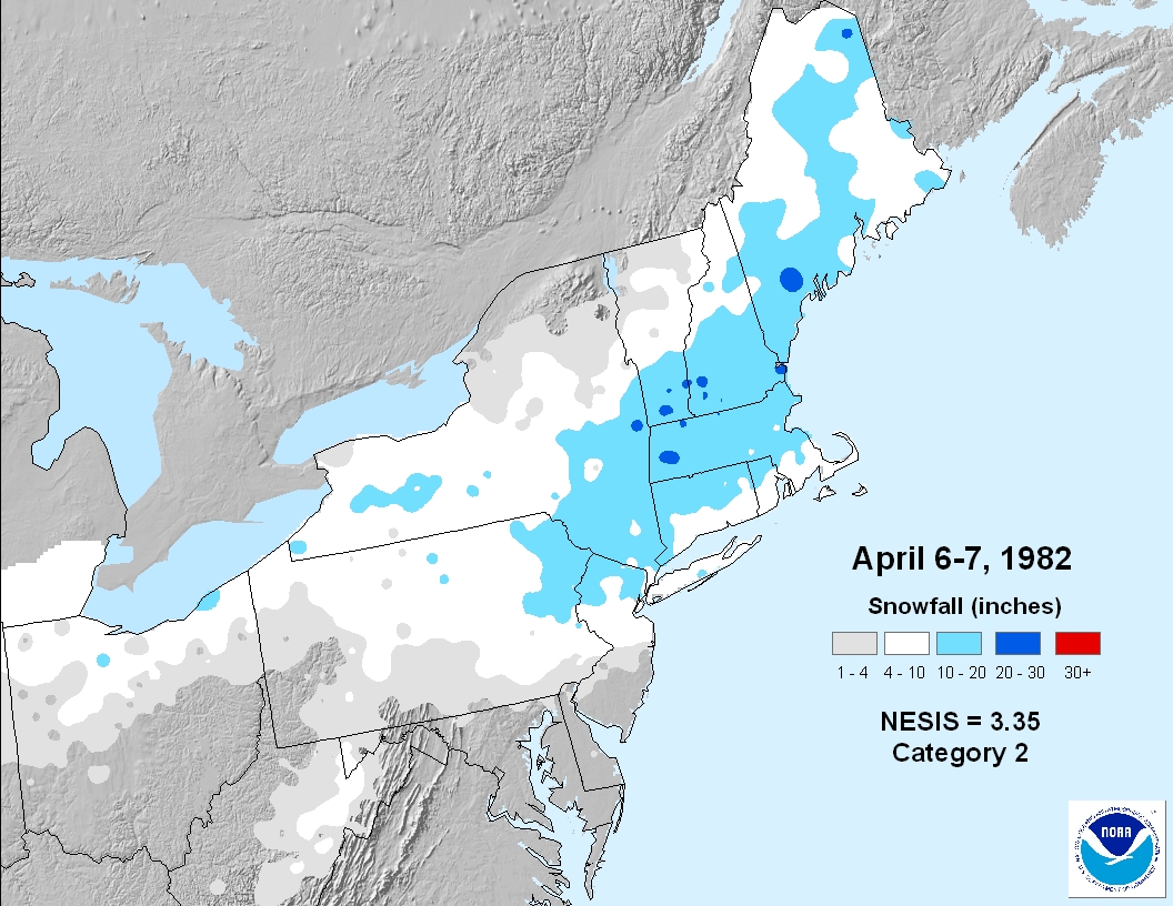
Shutting down highways, offices and schools this weather event is considered the worst April snowstorm in local history. The April snowstorm was accompanied by heavy snowfall, high winds, blizzard conditions and most notably; extensive thunderstorm activity. Most areas saw one to two feet of snow Albany received 17.7 inches of snow from this storm which stands as the greatest snowstorm for April for Albany. The winter of 1981-82 is one the snowiest on record for Albany with 97.1 inches. NESIS: Category 2 - Significant.Wind gusts of 40 MPH were recorded in Rensselaer, NY while gusts of 70 to 80 MPH were observed in Massachusetts and Connecticut.
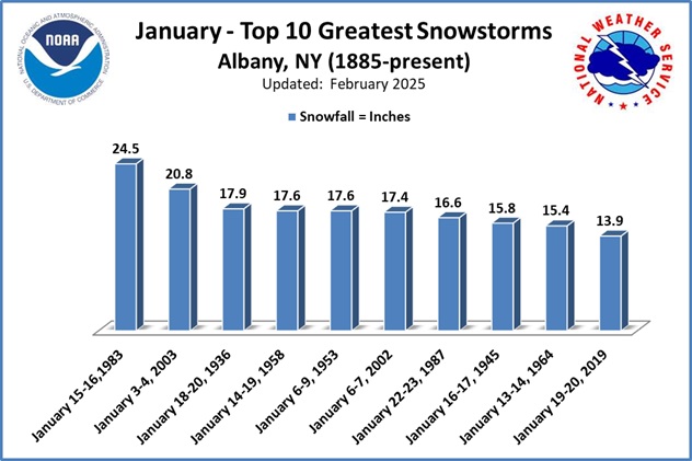
Although well-predicted, this classic nor'easter raised havoc across eastern New York and New England. Albany reported 24.5 inches with amounts of almost 30 inches reported in Saratoga County, but less than a foot in the lower Hudson Valley. Up to 20” of snow in the Berkshires with 12-18 inches in southern Vermont and Northwest Connecticut. For Albany, this storm is the greatest January snowfall on record and one of the greatest stormsnows. The heavy snow brought travel to a standstill across many locations, and may injuries were reported due to auto accidents.
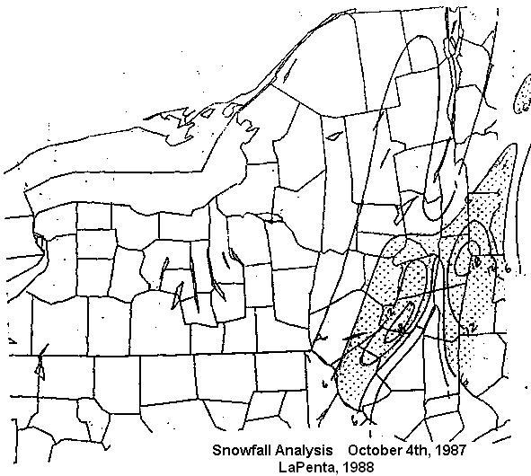
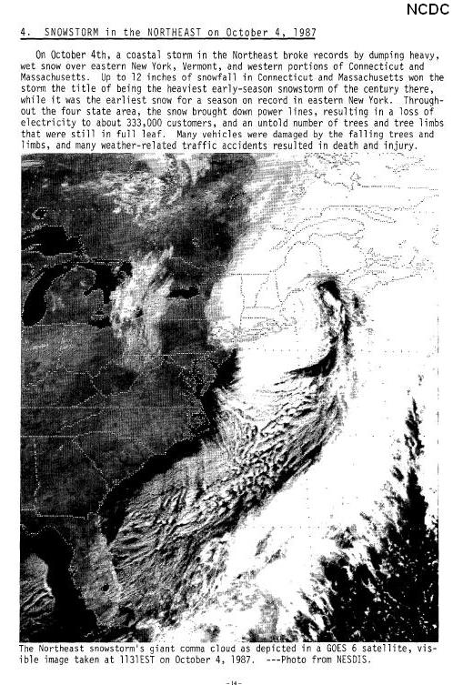
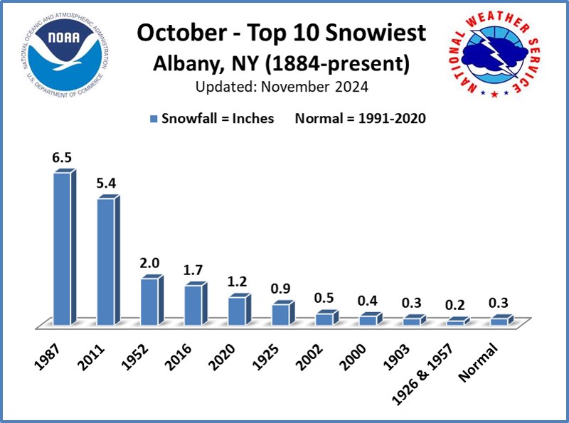
Three inches up to about 2 feet of extremely wet snow fell across eastern New York and western New England resulting in many deaths and injuries and an enormous amount property damage. Snow to liquid ratios were as low as 3.5 to 1. The storm wreaked havoc on the area causing widespread power outages. The trees still had their leaves which was a major contributing factor to the number of trees and limbs that came down taking out power lines. Numerous branches and trees were felled taking down power lines with them, blocking roads and damaging houses. Albany was described as "looking like a war zone." Hundreds of thousands of people were without power; some for up to two weeks. It was the most snow that ever fell during the month of October in Albany and is the earliest measurable snowfall for Albany, 6.5; inches were reported. An updated case study of this storm was done by Finch and Frank (2010).
This storm produced incredible snowfall totals across many mountainous locations, while barely having any effect on valley locations. Strong east winds caused the air to "downslope" off the Berkshires and Taconics, and "dry it out." Snowfall totals in the Berkshires ranged from 30 to 48 inches with drifts up to 12 feet. Schools were closed for a week and the national guard had to bring in heavy equipment to remove the snow. The Catskills and Helderbergs also got their share of snow with 18 to 39 inches reported. On Friday, December 11, at the height of the storm, the city of Albany received a half inch of snow with temperatures in the middle 30's. Albany did eventually get 6", but most of that fell toward the end of the storm, on Saturday the 12th, after the winds turned more northerly. The winter of 1992-93 is one of the snowiest on record for Albany with 94.2 inches.
A low pressure system tracking east across the Tennessee Valley moved into the region early on the 18th. The colder air the storm brought in from the north turned rain into a wet heavy snow across much of Eastern New York in the morning hours. Many elevated locations saw significant snowfall, 8 inches was reported at Prattsville, Greene County while Summit in Schoharie County received 6.5 inches. In higher elevation regions snow caused tree limbs and wires to come down, and power outages were reported in the Catskills. The 2.2 inches that fell at Albany International Airport was officially the latest measurable snowfall ever recorded in the season and the second greatest snowfall for the entire month of May.
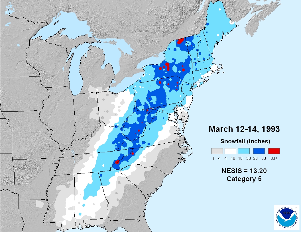
It was called a superstorm because it affected the entire eastern third of the U.S. There was a major severe weather event in the southeast, flooding and snow in the Mid-Atlantic states and blizzard conditions in the northeast. An intense area of low pressure moved out of the Gulf of America and northward along the east coast, dropping the pressure to record levels at many locations along the eastern seaboard, Albany reported 28.68 inches of mercury, the fifth lowest pressure on record. The storm dumped 26.6 inches at Albany, the 2nd greatest March snowstorm record and the 2nd greatest snowstorm on record, while other areas received as much as 40 inches, with Halcott Center reporting 40 inches and Prattsville coming in with 36 inches. During the peak of the storm, snow was falling at the rate of 5 or 6 inches an hour in some locations. Strong winds compounded the problem as there was significant blowing and drifting of the snow, as well as structural damage. Travel was extremely difficult and a state of emergency was declared across most of eastern and central New York state. The winter of 1992-93 is one of the snowiest on record for Albany with 94.2 inches. NESIS: Category 5 - Extreme. Rated #1.
Unprecedented back to back snowstorms buried parts of the Northeast during the Christmas and New Years 2002-2003 holiday season. Both storms produced over 20 inches of snow in Albany. During the Fall and early Winter an active subtropical jet stream had helped produced an active storm track up the Atlantic Seaboard. The first storm on Christmas Day was the biggest snowstorm since the “Superstorm” of 1993. 21” of snow reported at Albany with 6-16 inches in western New England and considerable blowing and drifting. The New York State Thruway was closed between the cities of Catskill and Syracuse. Many stranded in the Albany International Airport on Christmas Night as flights were cancelled. The second storm produced 20.8 inches of snow at Albany. It was the first time since 1887-88 that two storms of more than 20 inches were recorded at Albany during the same winter. The second storm combined with ice left on trees from an ice storm that occurred January 1-2 to bring down numerous trees and bring many power outages. The December 25-26 nor'easter is one the greatest snowstorms for December and greatest ever; while the January 3-4 nor'easter is the 2nd greatest snowstorm for January and also one of the greatest ever for Albany. The winter of 2002-03 is the 3rd snowiest on record for Albany with 105.4 inches.
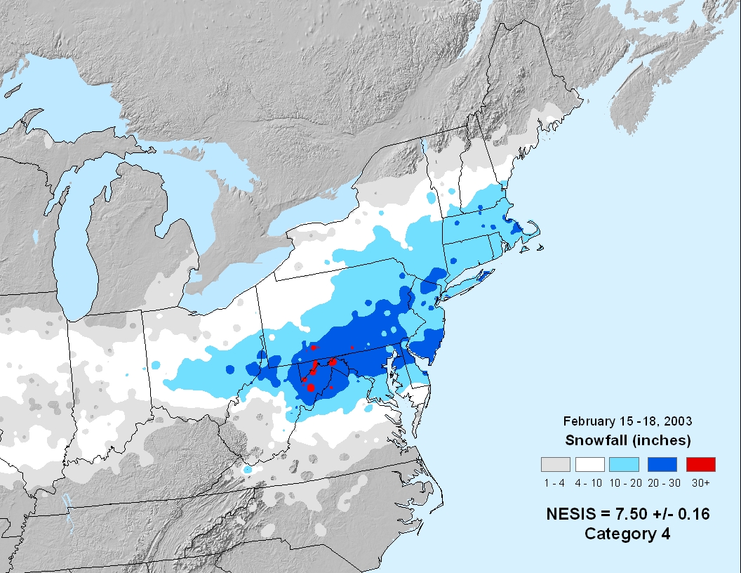
This was the third major snowstorm of the season affected much of eastern New York and adjacent western New England on President's Day. Although the heaviest snow from the storm fell from the mid Atlantic Region to New York City and southern New England, plenty of snow fell in Albany's forecast area. The heaviest totals were south and east of Capital District with up 2 feet in the Berkshires. The winter of 2002-03 is the 3rd snowiest on record for Albany with 105.4 inches. NESIS: Category 4 - Crippling.
The storm mainly impacted areas north of a line from Schoharie County, NY east to northern Berkshire County, MA. 12-18” of snow fell across the southern Adirondacks, Lake George and Glens Falls areas east to northern Bennington and Windham Counties in Vermont. South of that, a mixture of snow, sleet and freezing rain fell. Ice accumulations of ½” to 1” were reported on the third and fourth. All areas saw precipitation change to and end as snow on the fifth. The weight of ice and snow caused many downed trees and limbs and power outages. The storm was followed by gusty winds and below freezing temperatures through April 6 which resulted in additional power outages. Power was not fully restored to all areas until Tuesday evening, April 8.
There was very little snow across eastern New York and Western New England during November but that change dramatically with the December 6-7 snowstorm. The main area of low pressure eventually developed along the New Jersey coast Friday night and moved slowly toward Cape Cod Saturday and by Sunday afternoon had only reached a point just east of Cape Cod. This slow movement contributed to the large snow totals. Another factor that helped localize the snow was mesoscale banding. Forces in the atmosphere help concentrate upward vertical motion in bands during some storms and this can help concentrated heavy snow, especially if the band remains quasi-stationary for a long time. A major snow band set up late Saturday morning just east of the Hudson River and remained there into Saturday evening. Averill Park in Rensselaer County picked up 32 inches of snow. This snowstorm is one of the greatest for December for Albany.
A low pressure system formed over the southeastern United States and move northeast off the mid Atlantic coast Saturday night, the 11th. The low then intensified as it moved east-northeast passing south of Long Island Sunday morning. A very intense band of heavy snow developed producing snowfall rates as high as 3 to 4 inches an hour across extreme southeastern New York and across southern New England. The Albany Forecast Area was on the western edge of the precipitation field. Snowfall totals ranged from amounts over a foot across portions of Litchfield County in Connecticut to just under an inch at the NWS Office in Albany. NESIS: Category 3 - Major.
An arctic boundary moved southward across the region Saturday and stalled over the mid Atlantic region Saturday night. With the passage of the boundary, cold air was drawn in at and near the surface on northerly winds. Waves of low pressure moved eastward along the boundary over the long weekend resulting in an ice storm. A weak low passed to our south on Sunday resulting in periods of light freezing rain. However, the primary/deeper low moved from the Ohio Valley eastward across the local area Monday bringing heavier precipitation. The precipitation did start out as a period of sleet late Sunday night into early Monday morning with snow across the southern Adirondacks, however everything eventually changed to freezing rain. Significant ice accumulations occurred with over 100,000 utility customers losing power. Saratoga County was hit particularly hard with up to an inch of ice and accounting for about half the power outages. Ice ammulations from Albany County: pole & berries. To make matters worse, winds increased Monday evening placing additional strain on the already burden trees and power lines leading to additional power outages even after the freezing rain ended. The low deepened and moved off to the northeast across the Canadian Maritimes Monday night and Tuesday drawing arctic air across the region. By Wednesday morning, temperatures fell into the single digits to below zero.
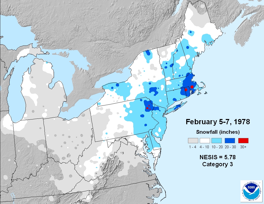
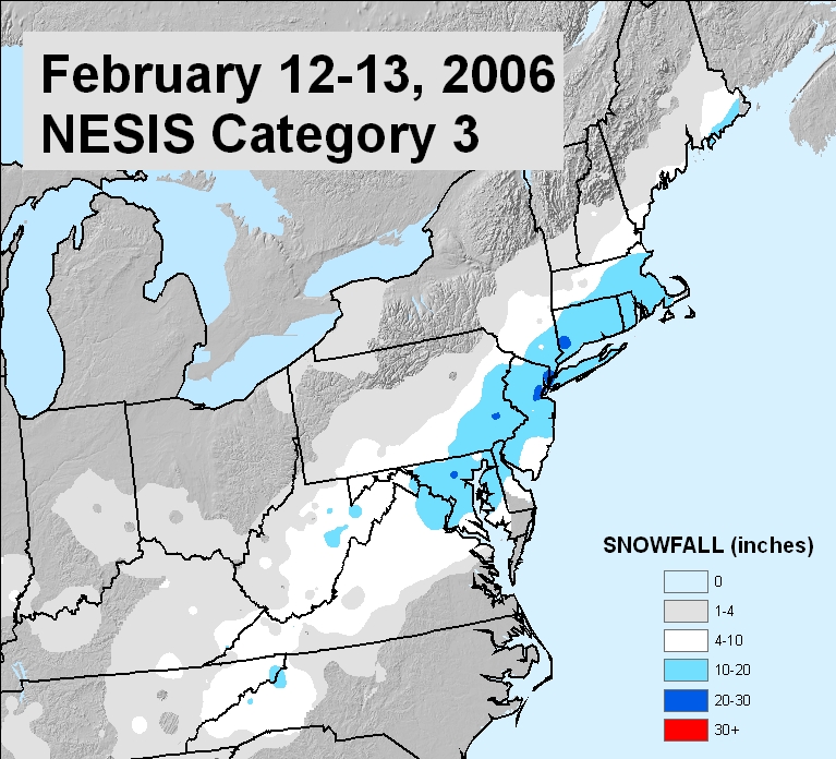
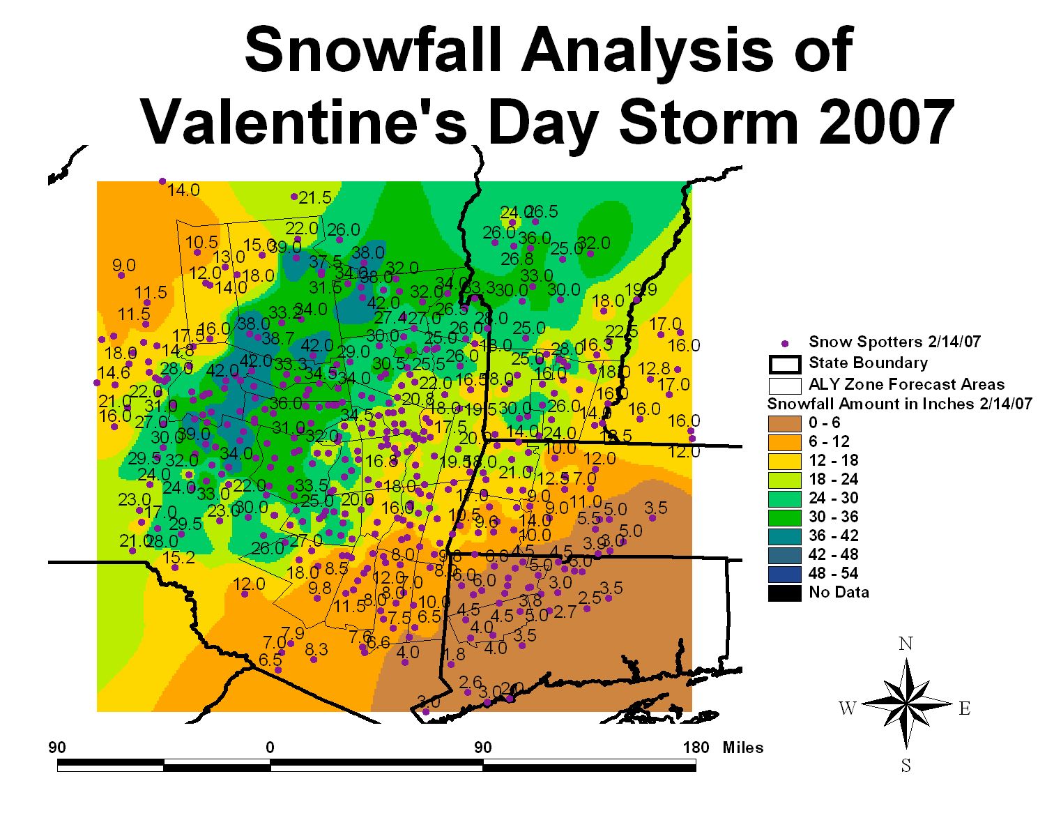
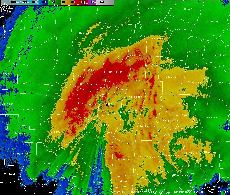
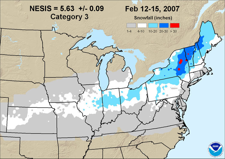
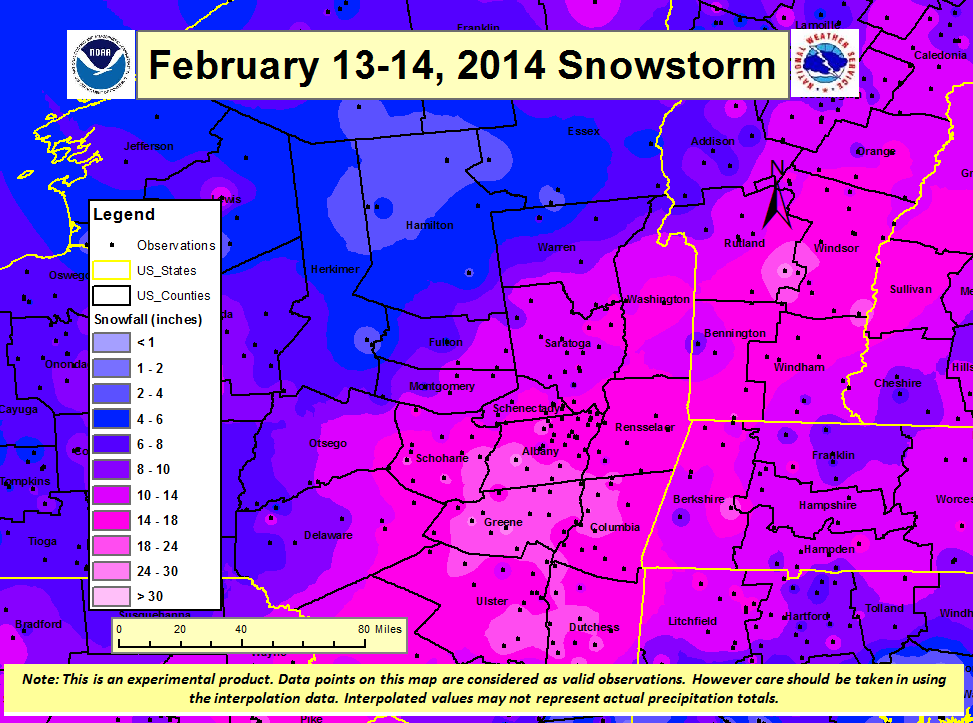
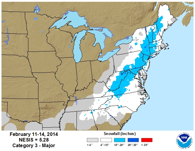
Low pressure formed over the deep south early on Monday, February 12th. This system headed eastward into the southeastern United States on Tuesday, February 13th and redeveloped along the mid atlantic coast by Wednesday morning, Valentine's Day. The low rapidly intensified as it passed just south of Long Island during the day Valentine's Day. The local area was pummeled with 1 to over 3 feet of snowfall (map). Intense mesoscale snow bands developed resulting in snowfall rates of 2 to 4 inches in an hour with localized amounts of 6 inches an hour occurring. Blowing and drifting occurred in the Capital District making some roads impassable. Some motorists abandoned cars in the road. Warmer air moved in aloft at 6000 to 8000 feet resulting in sleet mixing in with the snow at Albany and to the south. Six inches or more of sleet was reported in northwest Connecticut and the southern Berkshires of Massachusetts. Once the storm moved to our east Wednesday afternoon cold air was rapidly drawn back into the area. This storm is one of the greatest snowstorms for February for Albany. NESIS: Category 3 - Major.
The precipitation came down heavy at times Thursday night, December 11th. Hourly precipitation rates of quarter to a third of an inch were reported for several hours in the form freezing rain across much of the forecast area. Thunder was even reported. By the time the precipitation tapered off Friday morning, December 12th, ice accumulations ranged from around half of an inch up to an inch across portions of the Capital District and the Berkshires. North and west of the Capital District temperatures were colder and frozen precipitation fell. Snowfall reports ranged from 2 to 4 inches just north and west of the Capital District, where sleet mixed in along with lesser ice accumulations, up to 8 to 12 inches across portions of the southern Adirondacks. (Rain/Snow/Ice Reports) There was widespread tree and power line damage across the local area. An estimated 350,000 utility customers lost power across East Central New York and adjacent western New England. Over 60,000 customers were still out of power Monday morning, December 15th and over 10,000 customers were still out of power Wednesday morning, December 17th.
Part I: Generally, 1 to 2 feet of snow accumulated across much of east central New York and western New England with the highest amounts above 1500 feet. The heavy wet snow resulted in treacherous travel conditions, widespread power outages and even some building collapses. The power outages impacted six of Central Hudson Gas and Electric major transmission lines. Numerous trains were delayed and or canceled on Amtrak between Albany-Rensselaer and Poughkeepsie due to power outages. Part II: A powerful storm, the second in just a couple of days brought heavy rainfall and a heavy wet snow to the area. The heavy wet snow resulted in additional and continued widespread power outages, downed trees and power lines, treacherous travel, road closures, train delays, building collapses and snow emergencies. NESIS: Category 3 - Major.
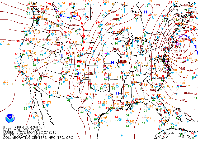
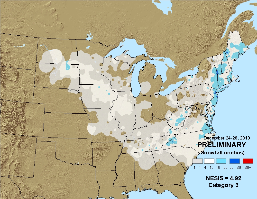
A major nor'easter brought significant snows and blizzard conditions to much of the northeastern United States Sunday, December 26th into Monday, December 27th. Bands of heavy snow withsnowfall rates of 1 to 3 inches an hour occurred across the region. Snowfall totals of 1 to 2 feet occurred mainly east of the Hudson River and across adjacent western New England. Explosive deepening (cyclogenesis) occurred Sunday night as the low moved northward toward Long Island. Snowfall amounts dropped off dramatically to the northwest of the Capital District. Strong and gusty winds caused significant blowing and drifting of the snow. Winds gusts across the local area were 35 to 45 mph with gusts of 50 to 70 mph reported across southeastern New York, Connecticut and eastern Massachusetts. NESIS: Category 3 - Major
An early season Nor'easter dumped heavy wet snow on across the area mainly to the south and east of the Capital District with snowfall amounts dropping off rapidly to the north and west. The storm tapped both Atlantic and subtropical moisture. Snowfall rates were as high as 2 to 4 inches an hour in mesoscale snowbands. Power outages occurred as trees and wires came down due to the heavy snow. The outages were the most widespread and prolonged in areas where leaves were still on the trees. Across east central New York snowfall amounts ranged from as little 1 to 4 inches across the northern portion of the Capital District, to 5 to 10 inches in the Hudson Valley including the southern portion of the Capital District, with 10 to 16 inches in the eastern Catskills, and 12 inches to almost 2 feet across the Taconics. Snow ratios across the area varied with lower ratios in the Hudson River Valley and higher ratio across the higher terrain. Across western New England snowfall amounts ranged from 1 to 1 1/2 feet in Litchfield County, in Berkshires from a foot to over 2 feet across the higher terrain of the northern Berkshires and across southern Vermont snowfall amounts ranged from 10 to 16 inches across Windham County and from 5 to 14 inches across Bennington County. With the 3.8 inhces of snow reported at Alabny from this storm combined with the 1.6 inches that fell on the 27th made October 2011 the 2nd snowiest on record for Albany.
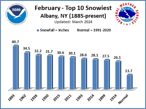
An exceptional winter storm impacted the region. Well ahead of the storm system, a heavy band of snowfall moved from south to north across the region. Snow fell at rates of up to three inches per hour, causing significant travel issues across the region. After a break in the steady snowfall heavy precipitation returned with significant snowfall rates of up to three inches per hour. Some sleet and freezing rain mixed in with the snow across the mid-Hudson Valley and Taconics region for a period. Between 1 to 2 feet of snow fell across much of the Lake George Saratoga Region, Capital Region, Schoharie Valley, eastern Catskills, Taconics, and mid-Hudson Valley. Somewhat lower amounts of 4 to 10 inches fell across the Adirondacks and western Mohawk Valley. Very strong winds, gusting as high as 40 mph led to significant blowing and drifting of the snowfall. Many towns and cities had difficultly with snow removal, as much of the snowfall also remained from a recent early February snowstorm. The weight of snow caused a few roof collapses across the region. The Albany International Airport reported 14.4 inches , so this storm missed making it into the Top 1o greatest snowstorms for February by only 0.2 inches. However, this storm helped place February 2014 as one of the Top 10 snowiest for February. NESIS: Category 3 - Major.
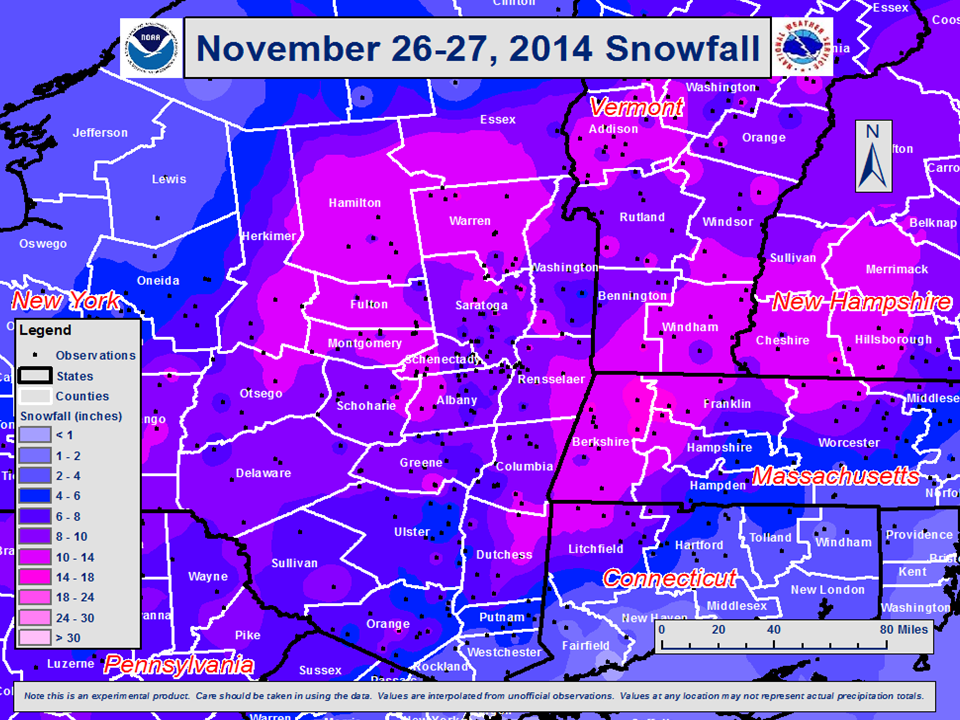
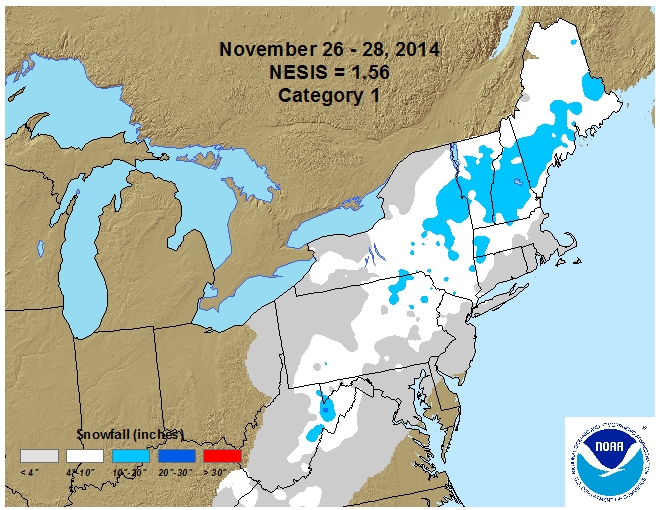
Early season nor'easter brought heavy snowfall to the region. The storm tapped gulf moisture as it developed along the gulf coast. The storm then tracked northeast along a frontal boundary eventually passing around 50 to 60 nautical miles southeast of Cape Cod on the evening of the 26th. The situation was complicated by the approach of an upper level disturbance. Snowfall reported ranged from as little as about 5 inches to 16 inches. At Albany, 10.4 inches of snow accumulated making it one of the greatest November snowstorms on record. November 2014 was one of the snowiest on record for Albany. NESIS: Category 1 - Notable.
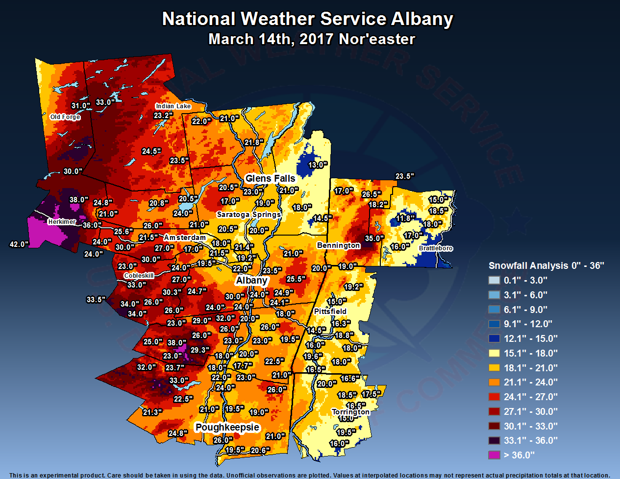
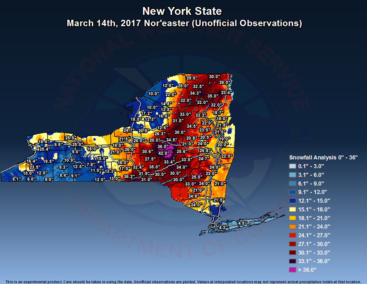
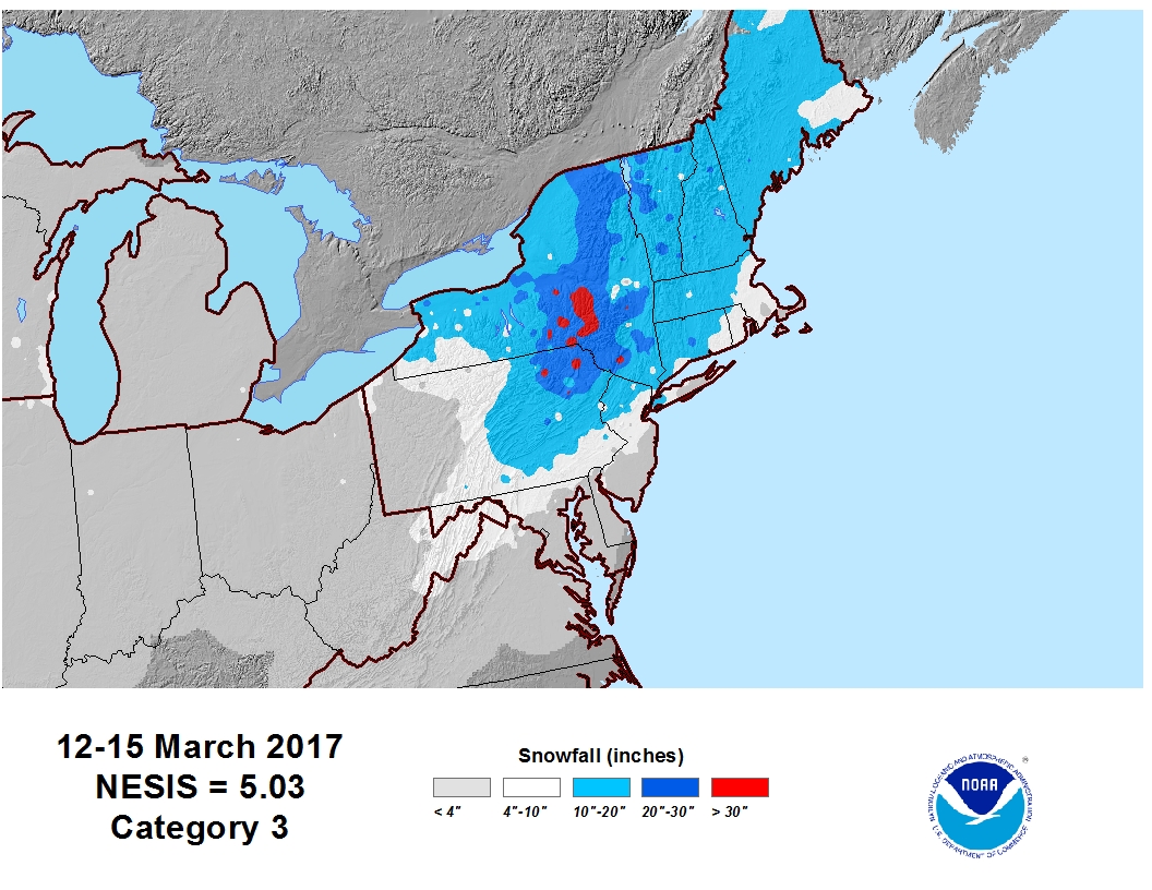
A very significant coastal snowstorm impacted the region March 14th featuring extremely heavy snowfall and blizzard conditions. This snowstorm was regarded as the largest snowstorm to impact the area since the Valentines Day 2007 Snowstorm/Blizzard. Snowfall reports ranged mainly from 1 to 3 feet, with some portions of the area picking up an amazing 36 to 42 inches of snowfall. The snow fell at 1 to 4 inches per hour for much of the day. A particularly heavy band of snow rotated northward across the region during the late morning into the early afternoon and stalled out over portions of the Mohawk Valley, resulting in an incredible report of 11.5 inches in 2 hours in Herkimer County. At the Albany International Airport 17.0 inches of snow accumulated making it one of the greatest March snowstorms on record and set a new daily record snowfall for the date. NESIS:
There was a widespread extreme public impact, with many roads severely impacted and schools closed for two days. A state of emergency was issued for all New York Counties, and tractor-trailers were banned on most area interstates. Numerous counties issued travel bans on county roads. The governor of Connecticut issued a statewide travel ban on state roads. Travel restrictions were issued for the Massachusetts Turnpike. Much of the train service across the region was cancelled, and all flights were grounded at Albany International Airport. The weight of the snow resulted in two barn collapses in Schoharie County, one of which was a 20,000 square-foot structure housing 150 cows. In addition to the snowfall, gusty winds up to 40 to 50 mph resulted in near-zero visibility and blizzard conditions across the Mid-Hudson Valley, Catskills, Capital District, Taconics, Lake George-Saratoga Region, Berkshires, Litchfield Hills and much of southern Vermont. At higher elevations across the Berkshires, winds gusted as high as 74 mph. The winds brought considerable blowing and drifting of snow.
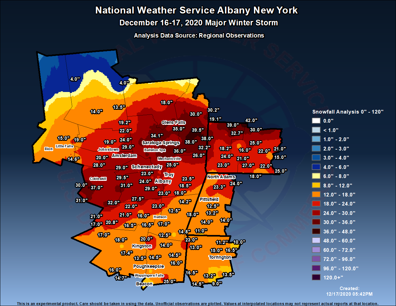
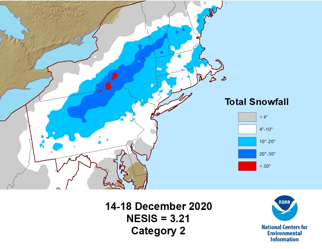
A significant coastal snowstorm impacted the region December 16-17th. Low pressure moved northward from the Outer Banks of North Carolina to just south of Long Island from Wednesday, December 16th into the early morning hours of Thursday, December 17th. Copious moisture was lifted over a dome of cold air over the Northeastern US, allowing snow to spread into eastern New York and western New England during the afternoon and evening hours of the 16th. Heavy snow bands of 1- 2" per hour were common with this initial activity. The heavy snow bands slowed their northward progress and pivoted, resulting in incredible snowfall rates of up to 6" per hour after midnight on the 17th through the late morning. A swath of very heavy snow occurred where these bands pivoted across Schoharie, Schenectady, Saratoga, southeast Warren, Washington, and northern Bennington Counties. Snowfall amounts of 2-3 feet were common in these areas before the snow finally ended in the late morning/early afternoon of the 17th. Elsewhere in the region, snow amounts of 1-2 feet were common most places aside from the southern Adirondacks which were on the periphery of the storm. At the Albany International Airport 22.9 inches of snow accumulated making it one of the greatest storms on record for Albany, one of the greatest December snowstorms on record and set a new daily record snowfall for December 17th with 19.7 inches. NESIS:
Back to Past Weather Events Page

