
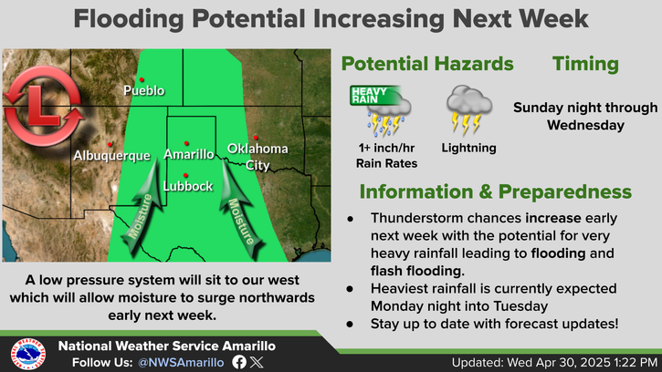
Well above normal temperatures are forecast to shift from the northern Plains through the Northeast U.S. over the long holiday weekend. A few strong to severe thunderstorm will be possible as well along with a potential for excessive rainfall. A tropical or subtropical depression could form off the Southeast U.S. coast over the weekend while drifting northward to northeastward. Read More >
Last Map Update: Fri, Jul 4, 2025 at 11:14:10 am CDT


|
Text Product Selector (Selected product opens in current window)
|
|
|
||||||||||||||||||||||||||||||||||||||||||||||||||||||||||||||||||||||||||||||||||||||||||||||||||||||||||||||||||||||||||||||||||||||||||||||||||||||||||||||||||||||||||||||||||||||||
| Aviation | Drought | Fire Weather | Hydrology | Severe Weather | Winter Weather |
 |
|||||
| Climate Graphs | Hourly Forecast | Long Range | Local Model Data | Precip Maps | Office Webcam |
| Education | Local Research | News | Skywarn | Weather Calculator | Weather Radio |


 Local Radar
 Weather Map
 NWS Amarillo Facebook