National Weather Service United States Department of Commerce

Areas of Extreme Heat and Fire Weather in the Northwest U.S.; Heavy Rain in the West and South-central U.S.

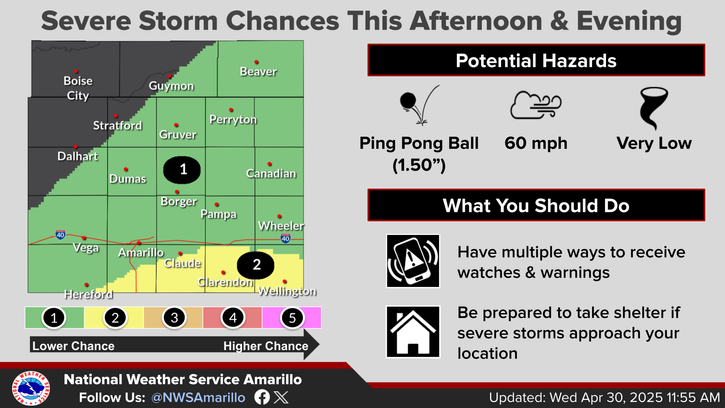
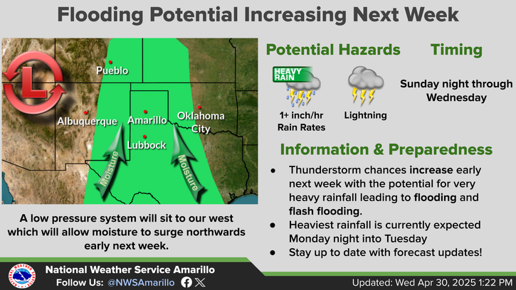
Extreme heat will continue in the interior Northwest into midweek before finally waning. Hot temperatures, dry, gusty winds, and isolated dry thunderstorms will bring critical fire weather. Heavy rain and thunderstorms are expected across portions of the Great Basin, Rockies, and central/southern Plains. An atmospheric river will bring heavy rain and strong winds to southwest Alaska. Read More >

Click a location below for detailed forecast.

Last Map Update: Tue, Aug 26, 2025 at 3:20:54 pm CDT

We expect fog to develop once again tonight into Wednesday morning, with some locations potentially seeing visibility drop below 1 mile. This could lead to impacts during the morning commute, so please utilize extra caution out on the roads!
Even though it will be a bit warmer later this week, cooler temperatures and rain chances are favored to continue this weekend into early next week. High temperatures in the 70s to lower 80s are possible during this time frame and daily chances for rain will persist through this time period.
Well below average temperatures are expected to continue today across the Panhandles thanks in part to rain chances and persistent cloud cover. Isolated showers will be possible throughout the day, but the better chances for rain and storms will be this evening through Wednesday morning.
After the brief cool down, temperatures will warm back up on Wednesday

Text Product Selector (Selected product opens in current window)


Current Observations ( )
Location Sky/Weather Temp (°F) Dewpt (°F) RH (%) Wind (mph) Pressure (inHg) Remarks
 Amarillo
N/A
N/A
N/A
N/A
N/A
N/A
N/A
 Borger
N/A
N/A
N/A
N/A
N/A
N/A
N/A
 Canadian
N/A
N/A
N/A
N/A
N/A
N/A
N/A
 Dalhart
N/A
N/A
N/A
N/A
N/A
N/A
N/A
 Dumas
N/A
N/A
N/A
N/A
N/A
N/A
N/A
 Guymon
N/A
N/A
N/A
N/A
N/A
N/A
N/A
 Hereford
N/A
N/A
N/A
N/A
N/A
N/A
N/A
 Pampa
N/A
N/A
N/A
N/A
N/A
N/A
N/A
 Perryton
N/A
N/A
N/A
N/A
N/A
N/A
N/A
 Amarillo 9NNE
N/A
N/A
N/A
N/A
N/A
N/A
N/A
 Amarillo 7SSE
N/A
N/A
N/A
N/A
N/A
N/A
N/A
 Bootleg 11WNW
N/A
N/A
N/A
N/A
N/A
N/A
N/A
 Canadian 6E
N/A
N/A
N/A
N/A
N/A
N/A
N/A
 Clarendon 2WSW
N/A
N/A
N/A
N/A
N/A
N/A
N/A
 Claude 12SW
N/A
N/A
N/A
N/A
N/A
N/A
N/A
 Hereford 2NW
N/A
N/A
N/A
N/A
N/A
N/A
N/A
 McLean 1E
N/A
N/A
N/A
N/A
N/A
N/A
N/A
 Palo Duro SP
N/A
N/A
N/A
N/A
N/A
N/A
N/A
 Pampa 2E
N/A
N/A
N/A
N/A
N/A
N/A
N/A
 Umbarger 3NNE
N/A
N/A
N/A
N/A
N/A
N/A
N/A
Note: "N/A" or "MISG" will be displayed if values are not available. In the LOCATION column, click on links for a list of recent observations at sites of interest. In the WIND column, VRB is "variable" and G is "gust". In the REMARKS column, HX is "heat index", WCI is "wind chill index", and VSB is "visibility" (if shown).


Aviation Drought Fire Weather Hydrology Severe Weather Winter Weather
 
Climate Graphs Hourly Forecast Long Range Local Model Data Precip Maps Heat
 
Education Local Research News Skywarn Weather Calculator Weather Radio