National Weather Service United States Department of Commerce

Severe Storms in the Upper Midwest and Northern Plains Saturday; Increasing Heat Across the South

Scattered severe thunderstorms capable of producing damaging winds, large to very large hail and a couple of tornadoes will be possible Saturday afternoon in the Upper Midwest and Great Plains. Stronger storms may produce heavy to excessive rainfall. Simmering heat will impact areas from the Southwest to the Gulf Coast and Southeast this weekend. Heat indices may exceed 100 degrees. Read More >

Upper Mississippi River Valley Astronomical (June 20-September 23) Summer Summary


Temperatures - Near to Above Average

During the astronomical summer of 2023 (June 21 through September 22), average temperatures ranged from 64.4°F at Medford Taylor County Airport, WI (AWOS) to 72.9°F at Decorah, IA (COOP) in the Upper Mississippi River Valley. Temperature anomalies ranged from near normal to 2°F warmer than normal. The hottest temperature was 105°F at Boscobel Airport, WI (COOP) and Decorah, IA (COOP) on August 23. Meanwhile, the coldest temperature was 31°F near Hillsboro, WI (COOP) and at Sparta Fort McCoy, WI (ASOS) on September 14.  Astronomical Summer Temperature Anomalies


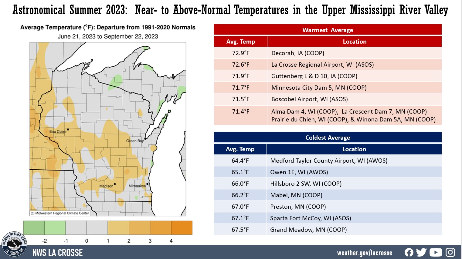
Rainfall - Drier than Average

Rainfall was below normal for astronomical summer. Rain totals ranged from 4.17" at Caledonia, MN (COOP) to 12.38" at Nora Springs 2.4 SSE, IA (CoCoRaHS). Rainfall anomalies ranged from 3" to 11" drier than normal. It was the driest astronomical summer at Grand Meadow, MN (4.65" - Previous record 5.22" in 1967 - Records began in 1887) and St. Ansgar, IA (4.29" - Previous Record was 6.39" in 2012 - Records began in 1948); and the 2nd driest at Austin, MN (only 1976 was drier - 3.47" - records began in 1937), Caledonia, MN (only 1976 was drier - 3.91" - records began in 1892); La Farge, WI (only 1948 was drier - 5.34" - records began in 1940); and Waukon 3 NNE, IA (only 1937 was drier - 4.08" - records began in 1940). The highest one-day precipitation was 2.40" at Osage, IA (COOP) from June 24-25. Astronomical Summer Rainfall Anomalies


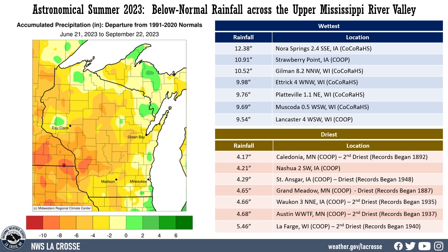
Below are the climate summaries for La Crosse, WI, and Rochester, MN.

La Crosse, WI


21st Warmest and Tied for the 16th driest Astronomical Summer in La Crosse WI


During the astronomical summer of 2023 (June 21 through September 22), it was warmer (21st warmest) and drier (tied for 16th driest with 1961) than the long-term average (1873-2023) at La Crosse Regional Airport. 

More details are listed below... 

La Crosse, WI Astronomical Summer Climate Graphic

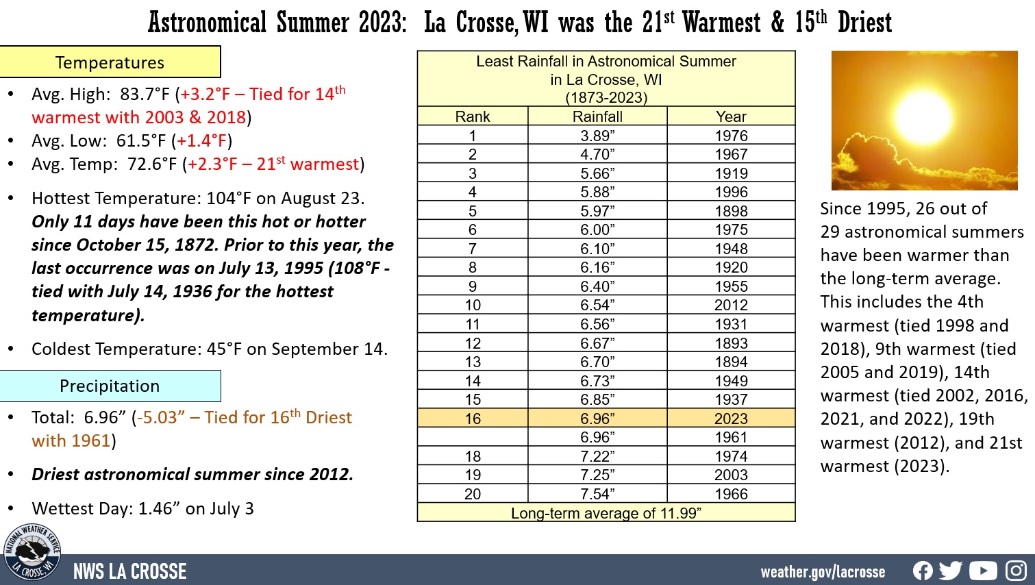
Temperatures - 21st Warmest

  • During astronomical summer, La Crosse Regional Airport had an average temperature of 72.6°F. This was 2.3°F warmer than the long-term average (1873-2023) of 70.3°F. This was the 21st warmest summer. Since 1995, 26 out of 29 astronomical summers have been warmer than the long-term average. This includes the 4th warmest (tied 1998 and 2018), 9th warmest (tied 2005 and 2019), 14th warmest (tied 2002, 2016, 2021, and 2022), 19th warmest (2012), and 21st warmest (2023). 
  • The average maximum temperature was 83.7°F. This was 3.2°F warmer than the long-term average of 80.5°F. Tied for 14th warmest with 2003 and 2018.
  • The average minimum temperature was 61.5°F. This was 1.4°F warmer than the long-term average of 60.1°F. 
  • Other temperature tidbits this summer...
  • The hottest temperature was 104°F on August 23. Only 11 days have been this hot or hotter. Prior to this year, the last occurrence was on July 13, 1995 (108°F - tied with July 14, 1936 for the hottest temperature).
  • The coldest high temperature was 67°F on July 12 and September 7. 
  • The warmest low temperature was 79°F on August 23. Only 30 days have had a low temperature which has been this warm or warmer. The last time to be this warm or warmer was July 5, 2021 (79°F). The warmest low temperature was 81°F July 21, 1901; July 13, 1995; and July 4, 2012.
  • The coldest low temperature was 45°F on September 14.
  • The temperature climbed to or exceeded 90°F on 21 days. Normally, there are 13 days in summer.  

Rainfall - Tied for the 16th Driest with 1961

  • During the astronomical summer, La Crosse Regional Airport received 6.96 inches of rain which was 5.03 inches drier than the long-term average (1873-2023) of 11.99 inches. This was tied for the 16th driest astronomical summer with 1961 and the driest since 2012 (6.54 inches - 10th driest). The table below contains the 20 driest astronomical summers in La Crosse, WI.  

   Top 20 Driest Astronomical Summers
             in La Crosse WI
               1873-2023

                Rainfall
    Rank          Total         Year
    ----      ------------      ----
      1        3.83 inches      1976
      2        4.70 inches      1967
      3        5.66 inches      1919
      4        5.88 inches      1996
      5        5.97 inches      1898
      6        6.00 inches      1975
      7        6.10 inches      1948
      8        6.16 inches      1920
      9        6.40 inches      1955
     10        6.54 inches      2012
     11        6.56 inches      1931
     12        6.67 inches      1893
     13        6.70 inches      1894
     14        6.73 inches      1949
     15        6.85 inches      1937
     16        6.96 inches      2023
               6.96 inches      1961
     18        7.22 inches      1974
     19        7.25 inches      2003
     20        7.54 inches      1966

  • The wettest calendar day occurred on July 3 when 1.46 inches of rain fell. Ironically this was the same value as last summer.
  • Measurable rain fell on 26 days (27.7%) and trace amounts fell on another 10 days (10.6%). 

Here is a breakdown of the summer rain...

None             58 days - 61.7%
Trace            10 days - 10.6%
0.01-0.09 inches 10 days - 10.6%
0.10-0.24 inches  9 days -  9.6%
0.25-0.49 inches  4 days -  5.3%
0.50-0.99 inches  0 days -  0.0%
1.00-1.99 inches  3 days -  2.5%
2.00-2.99 inches  0 days -  0.0%
3.00 inches +     0 day  -  0.0%


Rochester, MN


Astronomical Summer was Warmer and Much Drier (4th Driest) than the Long-Term Average in Rochester, MN


During the astronomical summer of 2023 (June 21 through September 22), it was warmer and much drier than the long-term average (1887 to 2023) at Rochester International Airport. 

More details are listed below...

Rochester, MN Astronomical Summer Climate Graphic

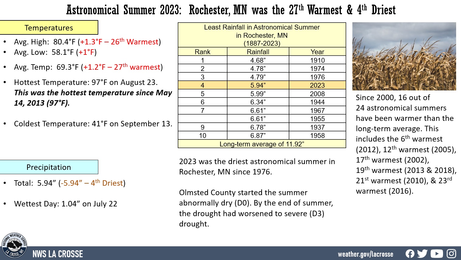
Temperatures - 27th Warmest

  • During astronomical summer, Rochester International Airport had an average temperature of 69.3°F. This was 1.2°F warmer than the long-term average (1887-2023) of 68.1°F. This was the 27th warmest summer. This was the warmest summer since 2018 (tied with 2013 for 19th warmest). Since 2000, 16 out of 24 astronomical summers have been warmer than the long-term average. This includes the 6th warmest (2012), 12th warmest (2005), 17th warmest (2002), 19th warmest (2013 & 2018), 21st warmest (2010), & 23rd warmest (2016).
  • The average maximum temperature was 80.4°F. This was 1.3°F warmer than the long-term average of 79.1°F. This was the 26th warmest. 
  • The average minimum temperature was 58.2°F. This was 1°F warmer than the long-term average of 57.1°F. 
  • Other temperature tidbits this summer...
  • The hottest temperature was 97°F on August 23. This was the hottest temperature since May 14, 2013 (97°F).
  • The coldest high temperature was 62°F on September 7. 
  • The warmest low temperature was 77°F on August 23. This was the warmest low temperature since July 21, 2016 (78°F).
  • The coldest temperature was 41°F on September 13. 
  • The temperature climbed to or exceeded 90°F on 5 days. Normally, there are 9 days per summer.  

Rainfall - 4th Driest

During the astronomical summer, Rochester International Airport received 5.94 inches of rain which was 5.99 inches drier than the long-term average of 11.93 inches. This is the 4th driest summer and the driest since 1976 (4.79 inches- 3rd driest). Only 3 out of the last 10 summers have been drier than the long-term (1887-2023) average. The table below contains the 10 driest astronomical summers in Rochester.  

   Top 10 Driest Astronomical Summers
             in Rochester MN
               1887-2023

                Rainfall
    Rank          Total         Year
    ----      ------------      ----
      1        4.68 inches      1910
      2        4.78 inches      1974
      3        4.79 inches      1976
      4        5.94 inches      2023
      5        5.99 inches      2008
      6        6.34 inches      1944
      7        6.61 inches      1967
               6.61 inches      1955
      9        6.78 inches      1937
     10        6.87 inches      1958

  • The wettest day occurred on July 22 when 1.04 inches of rain fell.
  • Measurable rain fell on 21 days (22.3%) and trace amounts fell on another 15 days (16%). 
  • Olmsted County started the summer abnormally dry (D0). By the end of summer, the drought had worsened to severe (D3) drought.

Here is a breakdown of the summer rain...

None             58 days - 61.7%
Trace            15 days - 16.0%
0.01-0.09 inches 10 days - 10.6%
0.10-0.24 inches  2 days -  2.1%
0.25-0.49 inches  3 days -  3.2%
0.50-0.99 inches  5 days -  5.3%
1.00-1.99 inches  1 day -   1.1%
2.00-2.99 inches  0 days -    0%
3.00 inches +     0 day  -    0%