Introduction
Wintertime poses a wide range of threats to residents of the Midwest. Whether it be exposure to the cold, vehicle accidents caused by slick roads, or fires resulting from the improper use of heaters, hundreds of people are injured or killed each year as a direct result of winter weather.
Winter storms range from a moderate snow over a few hours to a massive blizzard with blinding, wind-driven snow that lasts for several days. Some winter storms are large enough to affect several states while others affect only a single community.
High winds, freezing rain or sleet, heavy snowfall, and dangerously cold temperatures are the main hazards associated with winter storms. Impassable snow drifts can maroon people at home without utilities or other services for days after an event. Heavy snowfall and blizzards easily trap motorists in their vehicles and make walking to find help a deadly effort. Bitter cold temperatures and wind chills during and after a winter storm can lead to hypothermia and kill anyone caught outside for too long. The aftermath of a winter storm can impact a community or region for days, weeks or even months, incurring steep economic costs.
Terms to Know:
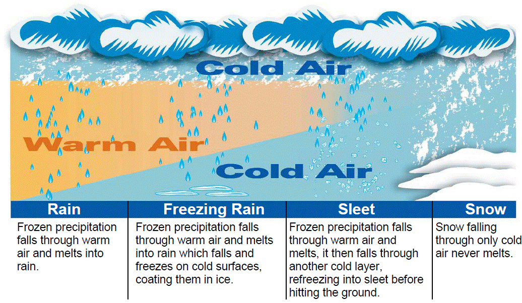
The chart below shows how the different types of winter precipitation are formed.
How the National Weather Service Keeps You Informed
The National Weather Service issues four "tiers" of alerts to inform you of incoming hazardous weather. Please take a moment to review and understand the differences between them.
Outlook:
Watch:
Warning:
Advisory:
Below is a break down of the different winter weather alerts issued by the National Weather Service in La Crosse
| Product | What It Means | What You Should Do |
| Hazardous Weather Outlook |
Will there be any hazardous winter weather in the next several days? |
If any hazardous winter weather is expected, check back for later forecasts, information, and possible watches. View latest Hazardous Weather Outlook |
| Winter Weather Advisory |
When any of the following criteria is expected to occur: Snow: Generally 3 to 5 inches Sleet: Less than 2 inches Ice: Less than 1/4 inch Blowing Snow: Visibility occasionally reduced to 1/4 mile due to blowing snow with winds less than 35 mph. |
On the Road: Unplowed/less traveled roads may be slick, so drive with caution. If blowing snow is occurring, drive at a safe speed and leave plenty of space between you and other drivers. At Home: Make sure you have the proper snow removing equipment to clear your sidewalks and driveways. |
| Winter Storm Watch |
When any of the following criteria is expected to occur: Snow: Generally 6 inches or more Sleet: 2 inches or more Ice: 1/4 inch or more Blizzard Conditions: Visibility reduced to 1/4 of a mile or less due to blowing snow with winds of at least 35 mph for at least 3 hours. |
On the Road: Consider changing your travel plans. If you must drive, carry a winter survival kit in your car and be prepared for delays. At Home: Make sure you have the proper snow removing equipment to clear your sidewalks and driveways. If an exceptionally high amount of snow is forecast, be prepared to remain at home for a day or two. |
| Winter Storm Warning |
When any of the following criteria is expected to occur: Snow: 6 inches or more Sleet: 2 inches or more Wintry Mix: A combination of snow, sleet, and/or freezing rain that may cause life-threatening conditions, especially if wind and blowing snow are a factor |
On the Road: Avoid any non-essential travel. If you must drive, carry a winter survival kit in your car and be prepared for delays. At Home: Make sure you have the proper snow removing equipment to clear your sidewalks and driveways. If an exceptionally high amount of snow is forecast, be prepared to remain at home for a day or two. |
| Blizzard Warning |
A combination of sustained winds or frequent wind gusts of at least 35 mph and visibilities of less than 1/4 of a mile due to snow and/or blowing snow for at least three straight hours. |
On the Road: Refrain from driving except in emergency situations, especially in open country. Always carry a winter survival kit in your car if you must drive. High winds and white-out conditions will make driving extremely dangerous. At Home: Be prepared to remain at home for a few days, especially if you live in a rural area. Snow drifts may be many feet in height, so make sure you have the proper snow removing equipment. |
| Ice Storm Warning |
A significant freezing rain event producing ice accumulations of 1/4 inch or more |
On the Road: Refrain from driving except in emergency situations. Roads will likely be treacherous and maintaining control of your car will be very difficult. At Home: Be prepared for possible long duration power outages and refrain from walking on ice covered surfaces outside. |
| Snow Squall Warning |
Intense, but limited duration, periods of moderate to heavy snowfall, accompanied by gusty winds resulting in reduced visibilities and whiteout conditions. |
On the Road: High winds and whiteout conditions will make driving extremely dangerous, and there is no safe place on highways during a snow squall. If snow squalls are in the forecast, delay travel or adjust your route to avoid them. If you encounter one while on the highway, reduce your speed, increase following distance, avoid slamming on brakes, and safely take the nearest exit until the snow squall passes. Always carry a winter survival kit in your car if you must travel. At Home: Remain at home until the short duration heavy snow band has ended and travel conditions have improved. |
| Cold Weather Advisory |
Apparent temperature (aka "wind chill") values are expected to fall to between -25°F and -34°F, with or without any wind. |
On the Road: Pack extra clothes and blankets in addition to your winter survival kit in your car in case you become stranded. At Home: If you go outdoors, dress accordingly by wearing well-insulated hats and gloves and putting on extra layers of clothing to keep warm. Frostbite could occur in as little as 30 minutes. |
| Extreme Cold Warning |
Apparent temperature (aka "wind chill") values are expected to fall to -35°F or colder, with or without any wind. |
On the Road: Pack extra clothes and blankets in addition to your winter survival kit in your car in case you get stranded. At Home: Seriously consider postponing any outdoor plans. Wear well insulated clothing if you must go outdoors. Frostbite could occur in as little as 10 minutes. |
Extreme Cold
Extremely cold air comes every winter in at least part of the country and affects millions of people across the United States. Extreme cold can come with (wind chill) or without wind - cold is cold and can quickly become life threatening if proper precautions are not taken.
Extreme Cold Warnings and Cold Weather Advisories are issued based on the apparent temperature. In calm conditions (no wind), the apparent temperature is the ambient air temperature. When there is wind, the apparent temperature is the "wind chill" or "feels like" temperature.
Wind Chill
Wind chill is not the actual air temperature; it is a "feels like" temperature based on the rate of heat loss from exposed skin caused by the effects of wind and cold. As the wind increases, human and animal bodies are cooled at a faster rate causing skin temperature to drop. Wind Chill does not impact inanimate objects like car radiators and exposed water pipes, because these objects cannot cool below the actual air temperature.
Wind Chill Chart
The Wind Chill Chart above includes a frostbite indicator, showing the points where temperature, wind speed and exposure time will produce frostbite on humans. The chart above includes three shaded areas of frostbite danger. Each shaded area shows how long (30, 10 and 5 minutes) a person can be exposed before frostbite develops.
For example, a temperature of 0°F and a wind speed of 15 mph will produce a wind chill temperature of -19°F. Under these conditions, exposed skin can freeze in 30 minutes.
Note: Wind chill temperature is only defined for temperatures at or below 50°F and wind speeds above 3 mph. Bright sunshine may increase the wind chill temperature by 10 to 18°F.
Frostbite
Occurs when the body's survival mechanisms kick in during extremely cold weather. To protect your vital inner organs, the body will cut off the circulation to your extremities: fingers, toes, nose, ears, etc., which will eventually freeze and cause damage to body tissue. This can occur within a matter of minutes during extremely cold temperatures if exposed skin is improperly protected.
Hypothermia
Is caused by prolonged exposure to very cold temperatures and occurs when a person's body temperature drops below 96°F. While hypothermia is most likely to occur at very cold temperatures, it can also occur at cool temperatures (above 40°F) if a person become chilled from rain, sweat, or submersion in cold water.
If you or someone you care about must venture outdoors during extreme cold this winter, dress in layers. Cover exposed skin to reduce the risk of frostbite or hypothermia. Try to seek shelter from the wind as much as possible while outside. Once inside again, change into dry clothing immediately if you are wet.
Symptoms and First Aid
| Symptoms | First Aid | |
| Frostbite |
Discolored skin (flushed, white, greyish-yellow, blue)
Skin that feels unusually firm or waxy
Numbness |
|
| Hypothermia |
Shivering
Stiff Muscles
Confusion
Difficulty Speaking
Sleepiness |
|
Staying Safe
Being safe in dangerous winter weather means not only to taking the appropriate steps during the storm, but also having the right supplies beforehand. If you wait to stock up on supplies until a watch or warning is issued, you run the risk of the supplies being out of stock or the store being closed.

 Fall is an excellent opportunity to check the winter supplies in your home & vehicle and stock up on anything that is running low.
Beforehand
The checklist below provides some basic guidance on what to have in your house/apartment during the winter should you be trapped by the snow or lose electricity. This is not an exhaustive list.
Food and water are vital necessities during a winter storm; however, these foods should be safe to consume should power be lost. Use the checklist below to help stock your shelves.
Additional information on assembling home disaster kits can be found on the FEMA website.
During the Event
During severe winter weather, the best advice is to stay inside your house. Plummeting temperatures and high winds that often accompany winter storms allow frostbite and hypothermia to set in quickly if you are outside. Also, road conditions will likely be very treacherous, especially if you live in rural areas. Monitor local media outlets for the latest information on the storm.
Beforehand
Each fall, take the time to go through your vehicle and winterize it. This can include:
 Most Importantly!
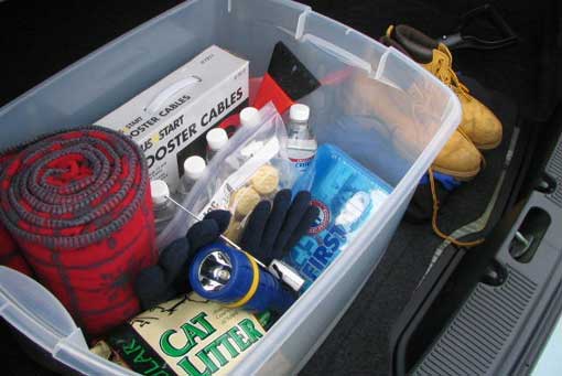
Make sure you carry a winter survival kit in your car in case you get stranded. You can use a large plastic tote or box to hold all of the needed items. If you already have one in your car, go through it and make sure it is fully stocked and ensure that any perishable items are still good to use. Items that should be in a winter survival kit are covered in the checklist below.
During the Event
 If you must drive during or immediately after a winter storm...
 If you become stranded in your vehicle...
Below are some tips for staying warm if you must venture outside in a winter storm or cold weather.
 Wear several layers of loose-fitting, lightweight, warm clothing (shirts, pants, socks, etc.) rather than one layer of heavy clothing. The outer garments should be tightly woven and water repellent.
If you are planning to take a hunting, camping, or other extended outdoor trip in the mid fall to mid spring timeframe, pay attention to the weather in the days leading up to the trip. If severe winter weather is forecast, consider postponing the trip. If you do head out:
 Should you become caught outside in a violent winter storm...
Additional Info