Overview
Rainfall over the past week has led to river rises across the area.
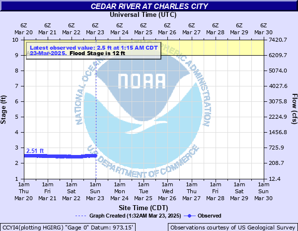
Cedar River
| Cedar River - Charles City [more details] |
 |
| Flood Categories |
| Major Flood: |
18 ft |
| Moderate Flood: |
15 ft |
| Flood Stage: |
12 ft |
| Action Stage: |
9 ft |
| Historical Crests: |
- 25.33 ft on 06/09/2008
- 22.81 ft on 07/21/1999
- 21.64 ft on 03/02/1965
- 21.60 ft on 03/27/1961
- 21.44 ft on 08/16/1993
|
|
Kickapoo River
| Kickapoo River - Viola [more details] |
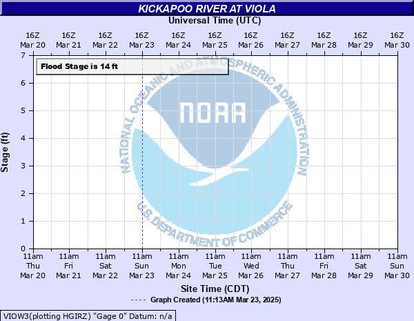 |
| Flood Categories |
| Major Flood: |
20 ft |
| Moderate Flood: |
17 ft |
| Flood Stage: |
14 ft |
| Action Stage: |
12 ft |
| Historical Crests: |
- 23.72 ft on 08/29/2018
- 21.25 ft on 06/09/2008
- 21.00 ft on 07/01/1978
- 20.25 ft on 07/21/2017
- 19.32 ft on 09/22/2016
|
|
| Kickapoo River - Readstown [more details] |
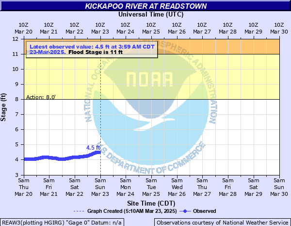 |
| Flood Categories |
| Major Flood: |
17 ft |
| Moderate Flood: |
14 ft |
| Flood Stage: |
11 ft |
| Action Stage: |
8 ft |
| Historical Crests: |
- 23.17 ft on 08/29/2018
- 19.65 ft on 06/09/2008
- 19.08 ft on 07/21/1951
- 18.82 ft on 08/20/2007
- 18.77 ft on 07/21/2017
|
|
| Kickapoo River - Soldiers Grove [more details] |
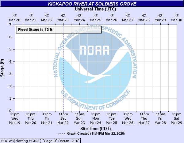 |
| Flood Categories |
| Major Flood: |
19 ft |
| Moderate Flood: |
16 ft |
| Flood Stage: |
13 ft |
| Action Stage: |
10 ft |
| Historical Crests: |
- 21.63 ft on 07/22/1951
- 21.21 ft on 06/09/2008
- 21.06 ft on 08/29/2018
- 20.00 ft on 07/02/1978
- 19.35 ft on 08/20/2007
|
|
| Kickapoo River - Gays Mills [more details] |
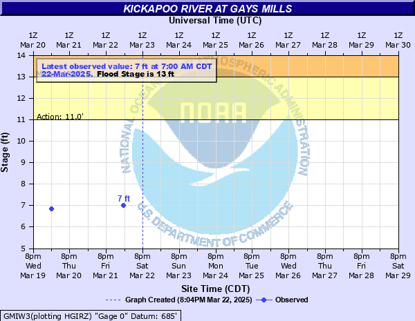 |
| Flood Categories |
| Major Flood: |
17 ft |
| Moderate Flood: |
15 ft |
| Flood Stage: |
13 ft |
| Action Stage: |
11 ft |
| Historical Crests: |
- 22.31 ft on 08/29/2018
- 20.44 ft on 06/09/2008
- 19.80 ft on 07/02/1978
- 19.79 ft on 08/20/2007
- 18.10 ft on 09/23/2016
|
|
| Kickapoo River - Steuben [more details] |
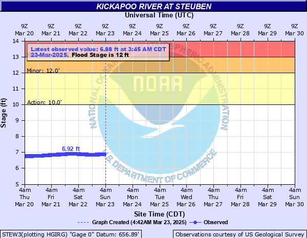 |
| Flood Categories |
| Major Flood: |
15 ft |
| Moderate Flood: |
13 ft |
| Flood Stage: |
12 ft |
| Action Stage: |
10 ft |
| Historical Crests: |
- 19.84 ft on 08/30/2018
- 19.16 ft on 06/10/2008
- 18.00 ft on 07/03/1978
- 16.84 ft on 08/20/2007
- 16.14 ft on 09/24/2016
|
|
Root River
| Root River - Houston [more details] |
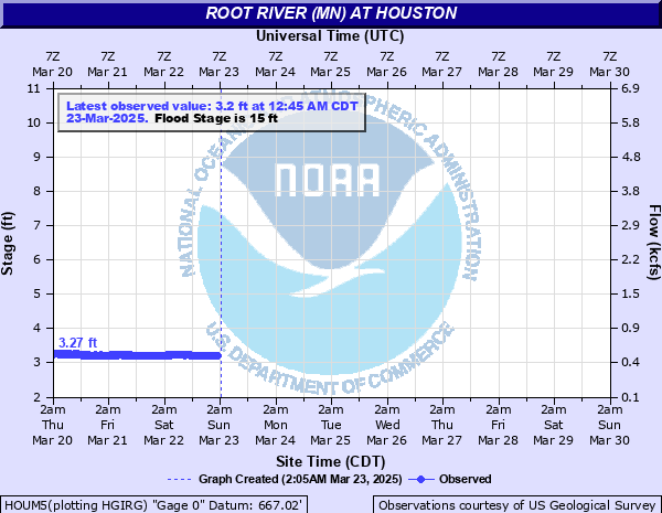 |
| Flood Categories |
| Major Flood: |
18 ft |
| Moderate Flood: |
17 ft |
| Flood Stage: |
15 ft |
| Action Stage: |
12 ft |
| Historical Crests: |
- 19.28 ft on 03/15/2019
- 18.32 ft on 03/02/1965
- 18.15 ft on 08/19/2007
- 17.59 ft on 06/02/2000
- 17.01 ft on 09/24/2016
|
|
Trempealeau River
| Trempealeau River - Arcadia [more details] |
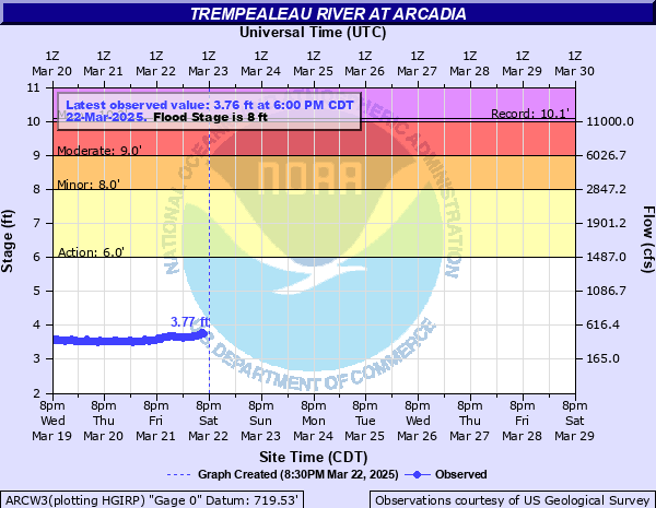 |
| Flood Categories |
| Major Flood: |
10 ft |
| Moderate Flood: |
9 ft |
| Flood Stage: |
8 ft |
| Action Stage: |
6 ft |
| Historical Crests: |
- 10.07 ft on 09/24/2010
- 9.61 ft on 07/20/2017
- 9.50 ft on 05/18/2017
- 9.20 ft on 08/14/2010
- 9.09 ft on 08/12/2016
|
|
| Trempealeau River - Dodge [more details] |
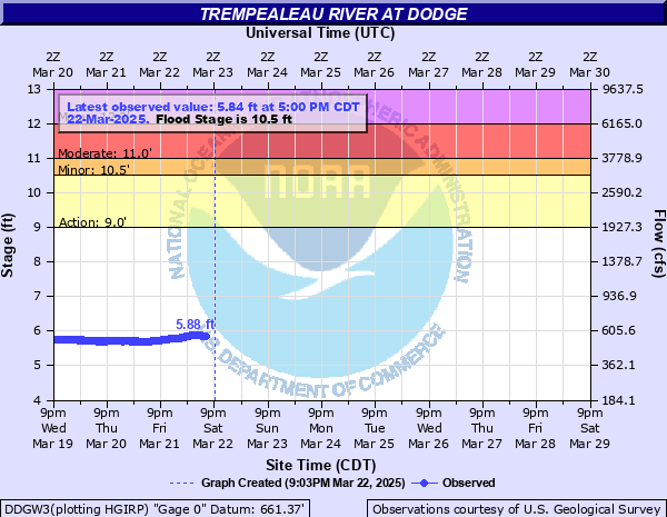 |
| Flood Categories |
| Major Flood: |
12 ft |
| Moderate Flood: |
11 ft |
| Flood Stage: |
9 ft |
| Action Stage: |
7 ft |
| Historical Crests: |
- 13.99 ft on 03/16/2019
- 12.75 ft on 09/25/2010
- 12.29 ft on 06/29/1998
- 12.19 ft on 07/21/2017
- 11.98 ft on 05/19/2017
|
|
Turkey River
| Turkey River - Elkader [more details] |
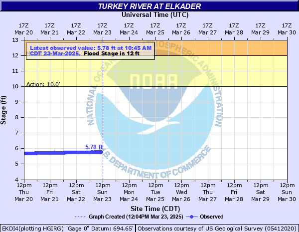 |
| Flood Categories |
| Major Flood: |
20 ft |
| Moderate Flood: |
18 ft |
| Flood Stage: |
12 ft |
| Action Stage: |
10 ft |
| Historical Crests: |
- 27.77 ft on 06/10/2008
- 27.32 ft on 06/15/1991
- 25.57 ft on 05/23/2004
- 22.87 ft on 08/30/2021
- 22.57 ft on 08/26/2016
|
|
| Turkey River - Garber [more details] |
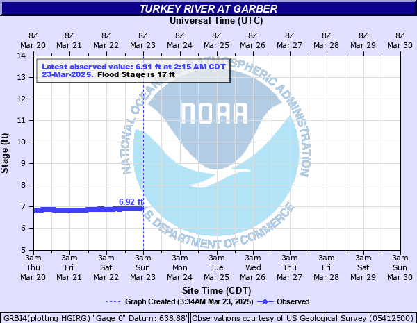 |
| Flood Categories |
| Major Flood: |
23 ft |
| Moderate Flood: |
20 ft |
| Flood Stage: |
17 ft |
| Action Stage: |
14 ft |
| Historical Crests: |
- 32.80 ft on 05/23/2004
- 30.91 ft on 05/17/1999
- 30.10 ft on 06/15/1991
- 29.13 ft on 06/10/2008
- 28.06 ft on 02/23/1922
|
|
| Turkey River - Spillville [more details] |
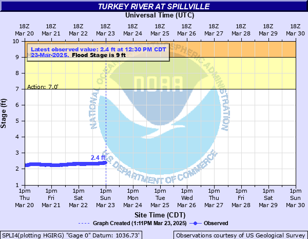 |
| Flood Categories |
| Major Flood: |
13 ft |
| Moderate Flood: |
11 ft |
| Flood Stage: |
9 ft |
| Action Stage: |
7 ft |
| Historical Crests: |
- 20.25 ft on 08/24/2016
- 18.40 ft on 06/01/1947 (P)
- 16.76 ft on 08/25/1990
- 16.73 ft on 07/12/1972
- 16.11 ft on 03/01/1965
|
|
Upper Iowa River
| Upper Iowa River - Decorah [more details] |
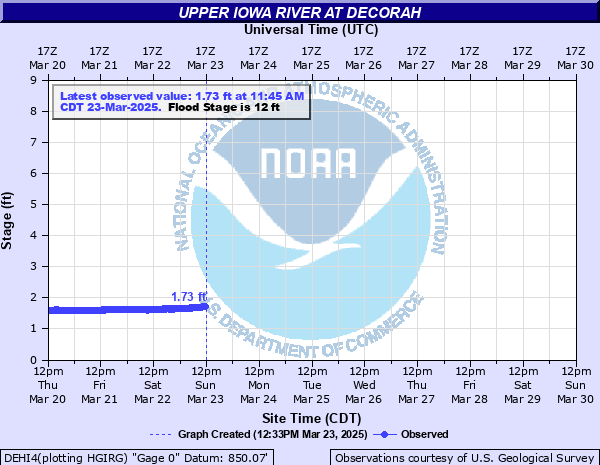 |
| Flood Categories |
| Major Flood: |
14 ft |
| Moderate Flood: |
13 ft |
| Flood Stage: |
12 ft |
| Action Stage: |
9 ft |
| Historical Crests: |
- 17.90 ft on 06/09/2008
- 14.35 ft on 08/17/1993
- 13.68 ft on 08/24/2016
- 13.08 ft on 03/27/1961
- 12.31 ft on 06/01/2000
|
|
| Upper Iowa River - Dorchester [more details] |
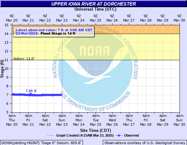 |
| Flood Categories |
| Major Flood: |
19 ft |
| Moderate Flood: |
17 ft |
| Flood Stage: |
14 ft |
| Action Stage: |
11 ft |
| Historical Crests: |
- 24.30 ft on 08/25/2016
- 22.46 ft on 06/09/2008
- 22.20 ft on 02/28/1948
- 21.80 ft on 05/30/1941
- 20.89 ft on 03/05/1937
|
|


 Weather Story
 Weather Map
 Local Radar