Overview
|
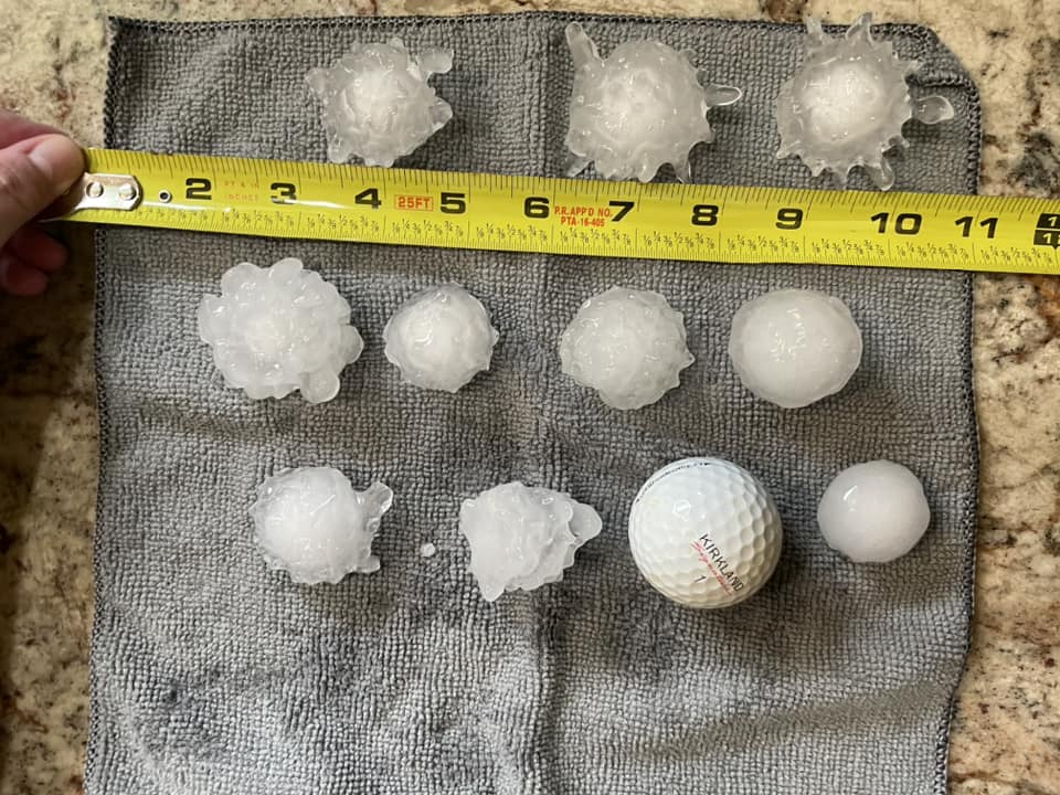
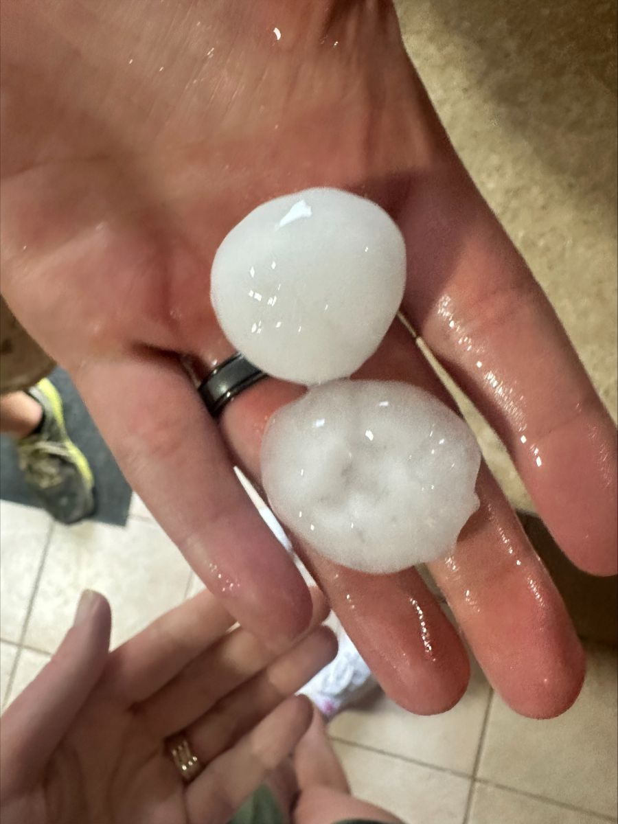
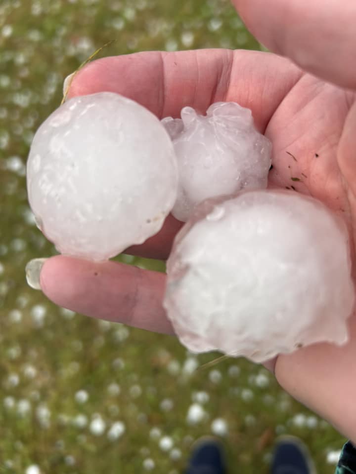
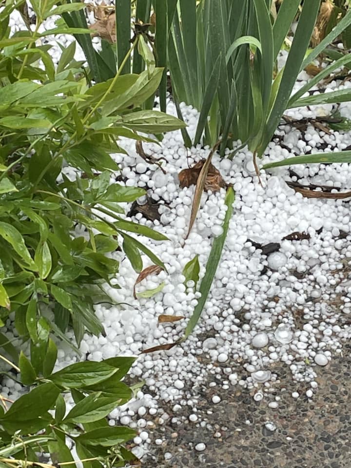
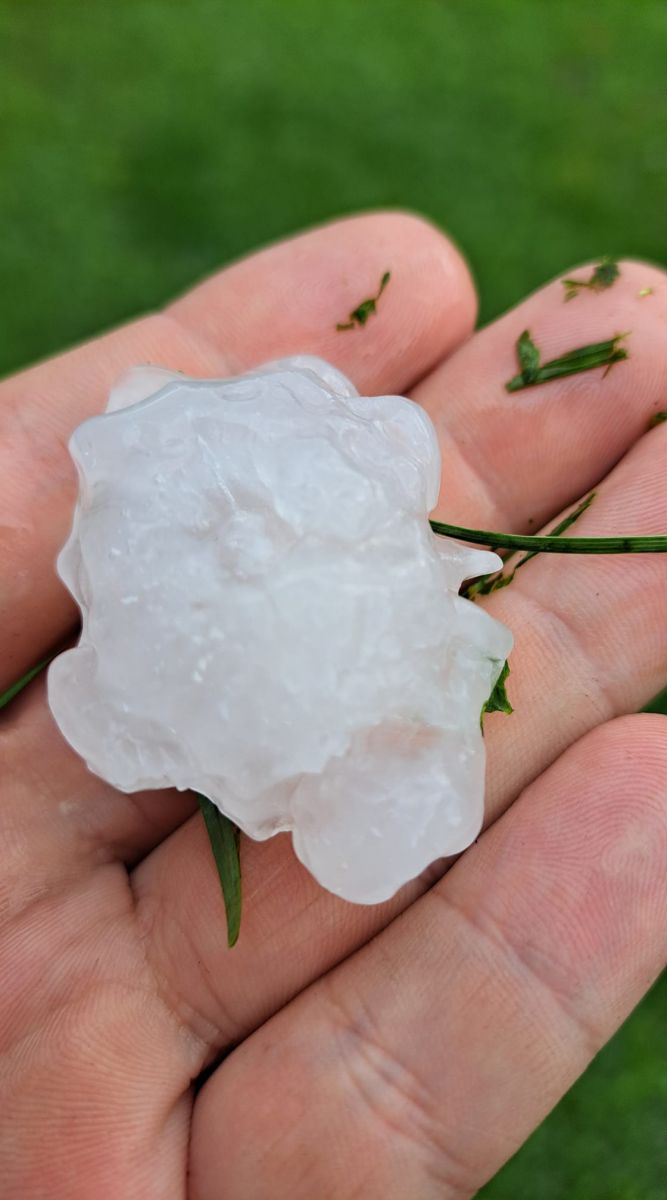
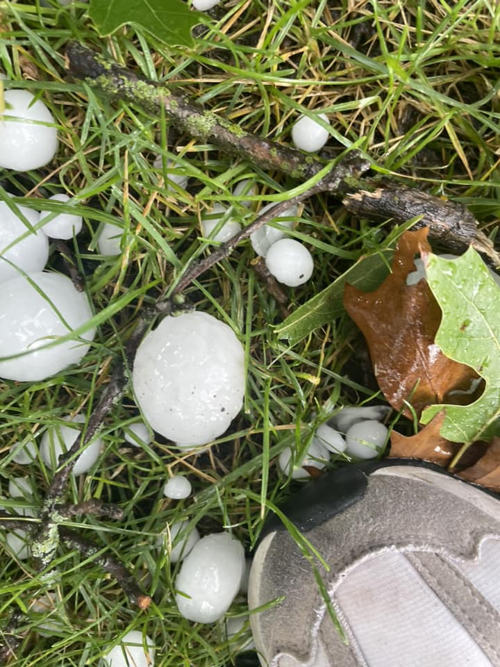
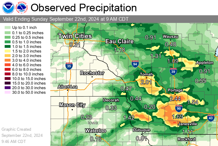
During the afternoon and evening hours of September 21st, a few rounds of strong to severe thunderstorms developed. The first round of storms developed north of a warm front with a weak upper level disturbance as warmer air and moisture returned to the region. Storms in the Eau Claire area pushed out an outflow boundary that traveled southward across much of the forecast area and provided an additional focus for storms. Meanwhile, by mid afternoon, a warm front was lifting north toward Rochester and Prairie Du Chien with temperatures warming to around 90, while the outflow boundary limited the high at La Crosse to 80 degrees. A few of the storms along and north of the outflow boundary produced 1 to 2" hail and damaging winds. Heavy rainfall also occurred. Storms that developed along the outflow produced some 1.0" to 3.0" rainfall amounts. Additional rainfall fell overnight and into the morning of the 22nd across Clayton and Grant Counties as the upper level trough pushed through, upping their rain totals in a band from the southwest to northeast. |
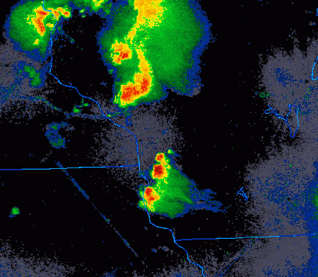 Radar loop from 11 AM CDT through 7 PM CDT Saturday |
Wind & Hail:
Wind & Hail Reports
.png) |
|||
| Hail & wind reports from across the area Saturday | Caption | Caption | Caption |
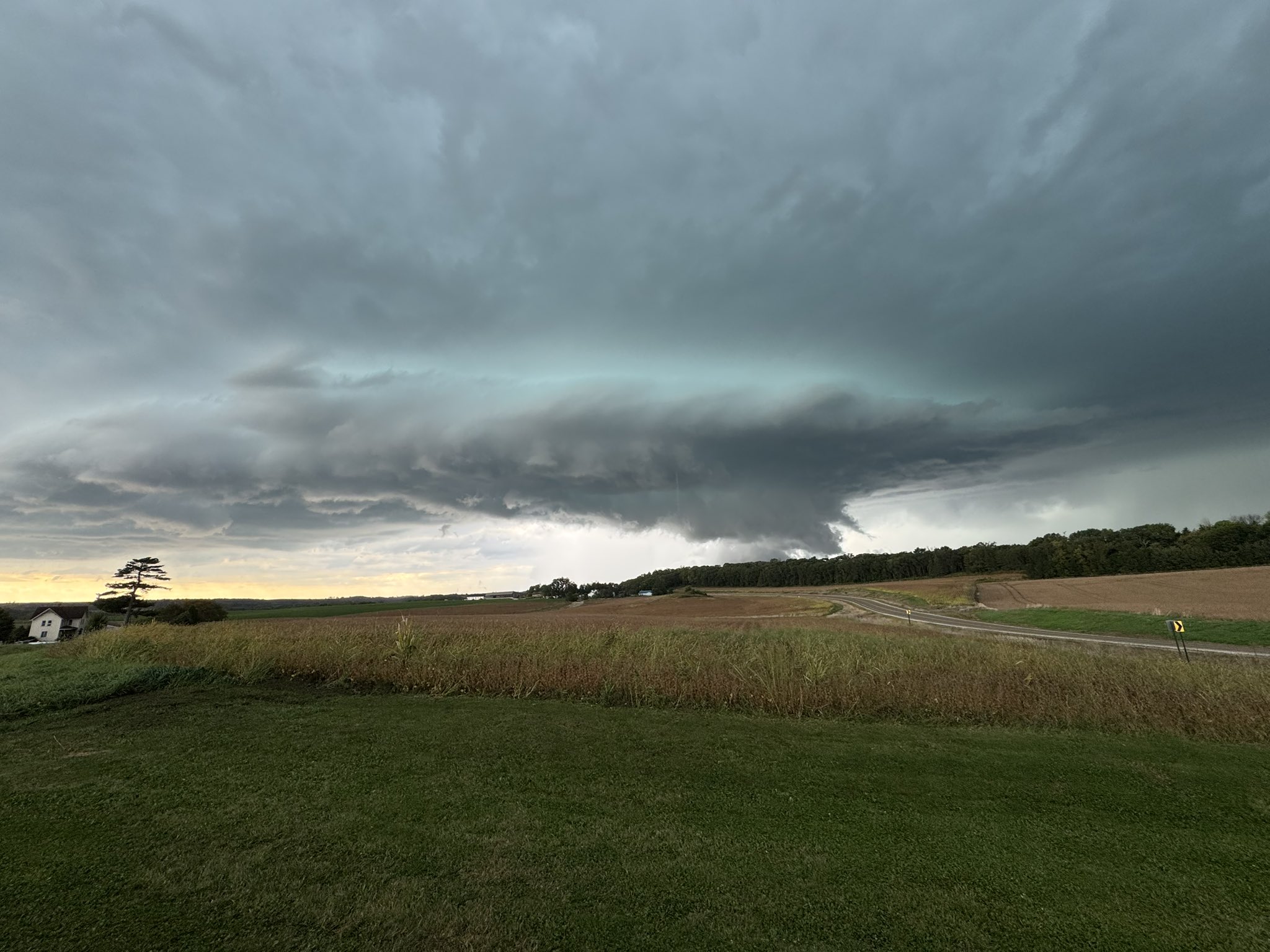
Photos:
Header
 |
 |
 |
 |
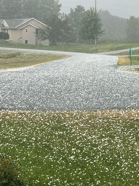
| Spring Grove (Olaf Johnson) |
Town of Holland (Beth Davidson) |
Holmen, WI (Patrick Smith) |
New Amsterdam (Maggie Breidel) |
 |
 |
 |
 |
| New Amsterdam/Holmen (Jennifer Hoff) |
North Bend (Branden Berg) |
New Amsterdam/Holmen Jennifer Hoff) |
Holmen (Slade Henderickson) |
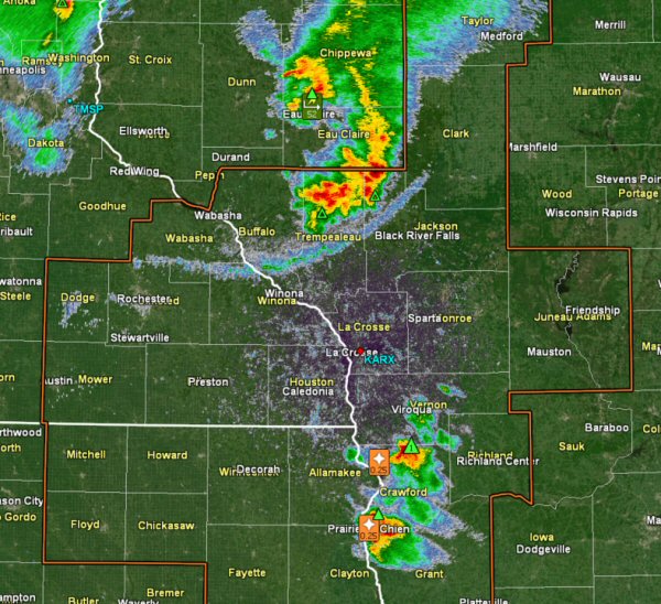
Radar:
Header
 |
 |
||
| Radar at 11 AM- Well defined outflow boundary that aided in storms through the day | Radar at 4:15 PM - Large hail reported with cell over Holmen | Caption | Caption |
Storm Reports

Rain Reports
 Public Information Statement
National Weather Service La Crosse WI
922 AM CDT Sun Sep 22 2024
...PRECIPITATION REPORTS...
Location Amount Time/Date Lat/Lon
Stitzer 1.8 SE 2.84 in 0700 AM 09/22 42.91N/90.60W
De Soto 2.51 in 0708 AM 09/22 43.43N/91.20W
1 S De Soto 2.33 in 0625 PM 09/21 43.41N/91.19W
Tomah 7.5 SSW 2.31 in 0700 AM 09/22 43.90N/90.58W
7.7 SE Caledonia 2.21 in 0800 AM 09/22 43.56N/91.41W
Steuben 4SE 2.02 in 0700 AM 09/22 43.13N/90.84W
Westboro 1.90 in 0725 PM 09/21 45.35N/90.30W
NECEDAH NWR RY DAM NECEDAH 5 1.88 in 0600 AM 09/22 44.06N/90.17W
Caledonia 1.88 in 0800 AM 09/22 43.63N/91.50W
Cashton 3 NNW 1.82 in 0655 AM 09/22 43.79N/90.80W
NECEDAH NWR RY DAM NECEDAH 5 1.82 in 0810 AM 09/22 44.06N/90.17W
Tomah 1.80 in 0726 AM 09/22 43.99N/90.50W
Houston 8.6 WSW 1.75 in 0700 AM 09/22 43.69N/91.72W
3 ESE Lemonweir 1.71 in 0530 AM 09/22 43.77N/89.96W
Warrens 4.7 WSW 1.48 in 0700 AM 09/22 44.10N/90.59W
Littleport 1.47 in 0845 AM 09/22 42.75N/91.37W
Prairie Du Chien 9.9 SE 1.46 in 0700 AM 09/22 42.95N/90.99W
Gays Mills 1.0 NE 1.43 in 0700 AM 09/22 43.33N/90.84W
Muscoda 0.5 WSW 1.36 in 0718 AM 09/22 43.18N/90.44W
Thorp 10.1 S 1.35 in 0600 AM 09/22 44.81N/90.82W
Greenwood 0.6 NNW 1.34 in 0700 AM 09/22 44.77N/90.60W
Eastman 2.4 NNE 1.33 in 0700 AM 09/22 43.20N/91.00W
Bloomington 3.5 N 1.22 in 0854 AM 09/22 42.94N/90.92W
1.0 E Mauston 1.15 in 0630 AM 09/22 43.79N/90.06W
Patch Grove 0.1 NNW 1.15 in 0700 AM 09/22 42.94N/90.97W
Boscobel Airport 1.11 in 0853 AM 09/22 43.15N/90.68W
Steuben 1.06 in 0845 AM 09/22 43.18N/90.86W
1 NNW Guttenberg 1.05 in 0835 AM 09/22 42.80N/91.11W
5 WSW Goodrich 1.00 in 0756 AM 09/22 45.12N/90.19W
5 SE Spring Grove 1.00 in 0955 PM 09/21 43.52N/91.57W
0.6 W Friendship 0.95 in 0700 AM 09/22 43.98N/89.83W
Ontario 0.90 in 0800 AM 09/22 43.72N/90.59W
Monona 9.8 N 0.90 in 0700 AM 09/22 43.19N/91.35W
Houston 5.3 SW 0.88 in 0645 AM 09/22 43.71N/91.65W
Guttenberg Dam 10 0.87 in 0600 AM 09/22 42.79N/91.10W
Volk Field 0.84 in 0855 AM 09/22 43.93N/90.27W
Medford 0.8 ENE 0.82 in 0700 AM 09/22 45.14N/90.33W
Elkader 6SSW 0.75 in 0700 AM 09/22 42.78N/91.45W
Oxford 4.3 W 0.74 in 0800 AM 09/22 43.79N/89.65W
Melrose 3.6 W 0.73 in 0700 AM 09/22 44.13N/91.07W
Nekoosa 8.0 SSE 0.72 in 0700 AM 09/22 44.21N/89.85W
0.6 W Necedah 0.71 in 0848 AM 09/22 44.02N/90.08W
7 ENE Decorah 0.69 in 0836 AM 09/22 43.34N/91.64W
Oxford 4.0 W 0.66 in 0700 AM 09/22 43.79N/89.64W
Lanesboro 0.65 in 0830 AM 09/22 43.72N/91.98W
Caledonia 5.4 S 0.63 in 0800 AM 09/22 43.56N/91.51W
Eitzen 3.8 E 0.62 in 0800 AM 09/22 43.50N/91.39W
Mabel 0.60 in 0707 AM 09/22 43.52N/91.76W
1 SSE Cashton 0.56 in 0700 AM 09/22 43.72N/90.77W
COLBY 0.56 in 0855 AM 09/22 44.91N/90.32W
McGregor 6.4 WNW 0.56 in 0649 AM 09/22 43.07N/91.29W
Lanesboro 0.2 SSW 0.54 in 0600 AM 09/22 43.72N/91.97W
Genoa Dam 8 0.53 in 0615 AM 09/22 43.57N/91.23W
2.8 E Harpers Ferry 0.50 in 0645 AM 09/22 43.21N/91.10W
Hillsboro 10.7 SW 0.48 in 0700 AM 09/22 43.55N/90.49W
Stoddard 4.7 NNE 0.45 in 0700 AM 09/22 43.72N/91.17W
Readstown 0.45 in 0759 AM 09/22 43.45N/90.77W
Onalaska 0.6 SW 0.41 in 0800 AM 09/22 43.88N/91.23W
Onalaska 1.9 E 0.40 in 0700 AM 09/22 43.89N/91.18W
Coon Valley 4.5 NNW 0.40 in 0700 AM 09/22 43.76N/91.06W
Mound Prairie 0.38 in 0700 AM 09/22 43.78N/91.45W
Viroqua 0.8 ESE 0.34 in 0700 AM 09/22 43.55N/90.87W
Black River Falls 0.33 in 0830 AM 09/22 44.29N/90.85W
Cassville 7.8 ENE 0.33 in 0700 AM 09/22 42.75N/90.84W
La Crescent 5.4 SW 0.32 in 0700 AM 09/22 43.78N/91.39W
Elkader 6.8 WSW 0.32 in 0615 AM 09/22 42.81N/91.52W
Ionia 2W 0.32 in 0845 AM 09/22 43.03N/92.50W
Blair (IFLOWS) 0.31 in 0319 AM 09/22 44.30N/91.23W
Caledonia 5.3 NNE 0.31 in 0600 AM 09/22 43.71N/91.46W
0.5 E Viroqua 0.30 in 0700 AM 09/22 43.56N/90.88W
La Crosse 4NNW 0.29 in 0730 AM 09/22 43.87N/91.27W
Stoddard 1.5 NE 0.28 in 0700 AM 09/22 43.67N/91.19W
0.8 SW Pigeon Falls (IFLOWS) 0.28 in 0537 AM 09/22 44.42N/91.22W
Onalaska 0.5 WSW 0.28 in 0700 AM 09/22 43.89N/91.23W
Cazenovia 4.4 SSW 0.26 in 0700 AM 09/22 43.47N/90.23W
La Crosse 2.4 S 0.26 in 0800 AM 09/22 43.79N/91.23W
La Crosse 1.3 SSE 0.25 in 0645 AM 09/22 43.81N/91.22W
La Crosse Regional Airport 0.22 in 0853 AM 09/22 43.88N/91.25W
Dickeyville 0.1 SW 0.22 in 0815 AM 09/22 42.62N/90.59W
Galesville 4.7 E 0.19 in 0743 AM 09/22 44.08N/91.26W
Lewiston 9.1 SSE 0.19 in 0700 AM 09/22 43.86N/91.80W
Decorah 4.9SE 0.18 in 0700 AM 09/22 43.26N/91.70W
Mondovi 0.17 in 0700 PM 09/21 44.56N/91.67W
Dodge 0.17 in 0845 AM 09/22 44.13N/91.55W
Richland Center 4.0 N 0.15 in 0800 AM 09/22 43.40N/90.39W
1 WSW Marquette 0.15 in 0800 AM 09/22 43.04N/91.21W
Whitehall (IFLOWS) 0.12 in 1009 PM 09/21 44.37N/91.32W
1 NE Platteville 0.12 in 0600 AM 09/22 42.75N/90.46W
NEILLSVILLE 0.11 in 0859 AM 09/22 44.61N/90.65W
Postville 5.5 NE 0.11 in 0700 AM 09/22 43.14N/91.49W
Mondovi 12.1 SSE 0.10 in 0700 AM 09/22 44.40N/91.60W
3 NE Nodine 0.07 in 0830 AM 09/22 43.94N/91.41W
Wykoff 3.1 NW 0.07 in 0700 AM 09/22 43.74N/92.31W
Decorah 0.05 in 0845 AM 09/22 43.30N/91.80W
Big Spring Fish Hatchery 0.03 in 0800 AM 09/22 42.91N/91.47W
New Hampton 0.4 SW 0.03 in 0700 AM 09/22 43.06N/92.32W
Dakota 0.02 in 0815 AM 09/22 43.91N/91.36W
3 S Dorchester 0.02 in 0700 AM 09/22 43.42N/91.51W
La Crescent 4.0 NNW 0.01 in 0700 AM 09/22 43.88N/91.34W
Rochester-Cascade Creek 0.01 in 0330 AM 09/22 44.03N/92.47W
Elgin 2SSW 0.01 in 0700 AM 09/22 44.10N/92.27W
1 NNW Fillmore 0.01 in 0830 AM 09/22 43.76N/92.27W
Winona 6.9 ESE T in 0700 AM 09/22 44.00N/91.55W
Oelwein 1 E T in 0630 AM 09/22 42.68N/91.88W
Observations are collected from a variety of sources with varying
equipment and exposures. We thank all volunteer weather observers
for their dedication. Not all data listed are considered official.
Public Information Statement
National Weather Service La Crosse WI
922 AM CDT Sun Sep 22 2024

...PRECIPITATION REPORTS...

Location                     Amount    Time/Date       Lat/Lon
Stitzer 1.8 SE               2.84 in   0700 AM 09/22   42.91N/90.60W
De Soto                      2.51 in   0708 AM 09/22   43.43N/91.20W
1 S De Soto                  2.33 in   0625 PM 09/21   43.41N/91.19W
Tomah 7.5 SSW                2.31 in   0700 AM 09/22   43.90N/90.58W
7.7 SE Caledonia             2.21 in   0800 AM 09/22   43.56N/91.41W
Steuben 4SE                  2.02 in   0700 AM 09/22   43.13N/90.84W
Westboro                     1.90 in   0725 PM 09/21   45.35N/90.30W
NECEDAH NWR RY DAM NECEDAH 5 1.88 in   0600 AM 09/22   44.06N/90.17W
Caledonia                    1.88 in   0800 AM 09/22   43.63N/91.50W
Cashton 3 NNW                1.82 in   0655 AM 09/22   43.79N/90.80W
NECEDAH NWR RY DAM NECEDAH 5 1.82 in   0810 AM 09/22   44.06N/90.17W
Tomah                        1.80 in   0726 AM 09/22   43.99N/90.50W
Houston 8.6 WSW              1.75 in   0700 AM 09/22   43.69N/91.72W
3 ESE Lemonweir              1.71 in   0530 AM 09/22   43.77N/89.96W
Warrens 4.7 WSW              1.48 in   0700 AM 09/22   44.10N/90.59W
Littleport                   1.47 in   0845 AM 09/22   42.75N/91.37W
Prairie Du Chien 9.9 SE      1.46 in   0700 AM 09/22   42.95N/90.99W
Gays Mills 1.0 NE            1.43 in   0700 AM 09/22   43.33N/90.84W
Muscoda 0.5 WSW              1.36 in   0718 AM 09/22   43.18N/90.44W
Thorp 10.1 S                 1.35 in   0600 AM 09/22   44.81N/90.82W
Greenwood 0.6 NNW            1.34 in   0700 AM 09/22   44.77N/90.60W
Eastman 2.4 NNE              1.33 in   0700 AM 09/22   43.20N/91.00W
Bloomington 3.5 N            1.22 in   0854 AM 09/22   42.94N/90.92W
1.0 E Mauston                1.15 in   0630 AM 09/22   43.79N/90.06W
Patch Grove 0.1 NNW          1.15 in   0700 AM 09/22   42.94N/90.97W
Boscobel Airport             1.11 in   0853 AM 09/22   43.15N/90.68W
Steuben                      1.06 in   0845 AM 09/22   43.18N/90.86W
1 NNW Guttenberg             1.05 in   0835 AM 09/22   42.80N/91.11W
5 WSW Goodrich               1.00 in   0756 AM 09/22   45.12N/90.19W
5 SE Spring Grove            1.00 in   0955 PM 09/21   43.52N/91.57W
0.6 W Friendship             0.95 in   0700 AM 09/22   43.98N/89.83W
Ontario                      0.90 in   0800 AM 09/22   43.72N/90.59W
Monona 9.8 N                 0.90 in   0700 AM 09/22   43.19N/91.35W
Houston 5.3 SW               0.88 in   0645 AM 09/22   43.71N/91.65W
Guttenberg Dam 10            0.87 in   0600 AM 09/22   42.79N/91.10W
Volk Field                   0.84 in   0855 AM 09/22   43.93N/90.27W
Medford 0.8 ENE              0.82 in   0700 AM 09/22   45.14N/90.33W
Elkader 6SSW                 0.75 in   0700 AM 09/22   42.78N/91.45W
Oxford 4.3 W                 0.74 in   0800 AM 09/22   43.79N/89.65W
Melrose 3.6 W                0.73 in   0700 AM 09/22   44.13N/91.07W
Nekoosa 8.0 SSE              0.72 in   0700 AM 09/22   44.21N/89.85W
0.6 W Necedah                0.71 in   0848 AM 09/22   44.02N/90.08W
7 ENE Decorah                0.69 in   0836 AM 09/22   43.34N/91.64W
Oxford 4.0 W                 0.66 in   0700 AM 09/22   43.79N/89.64W
Lanesboro                    0.65 in   0830 AM 09/22   43.72N/91.98W
Caledonia 5.4 S              0.63 in   0800 AM 09/22   43.56N/91.51W
Eitzen 3.8 E                 0.62 in   0800 AM 09/22   43.50N/91.39W
Mabel                        0.60 in   0707 AM 09/22   43.52N/91.76W
1 SSE Cashton                0.56 in   0700 AM 09/22   43.72N/90.77W
COLBY                        0.56 in   0855 AM 09/22   44.91N/90.32W
McGregor 6.4 WNW             0.56 in   0649 AM 09/22   43.07N/91.29W
Lanesboro 0.2 SSW            0.54 in   0600 AM 09/22   43.72N/91.97W
Genoa Dam 8                  0.53 in   0615 AM 09/22   43.57N/91.23W
2.8 E Harpers Ferry          0.50 in   0645 AM 09/22   43.21N/91.10W
Hillsboro 10.7 SW            0.48 in   0700 AM 09/22   43.55N/90.49W
Stoddard 4.7 NNE             0.45 in   0700 AM 09/22   43.72N/91.17W
Readstown                    0.45 in   0759 AM 09/22   43.45N/90.77W
Onalaska 0.6 SW              0.41 in   0800 AM 09/22   43.88N/91.23W
Onalaska 1.9 E               0.40 in   0700 AM 09/22   43.89N/91.18W
Coon Valley 4.5 NNW          0.40 in   0700 AM 09/22   43.76N/91.06W
Mound Prairie                0.38 in   0700 AM 09/22   43.78N/91.45W
Viroqua 0.8 ESE              0.34 in   0700 AM 09/22   43.55N/90.87W
Black River Falls            0.33 in   0830 AM 09/22   44.29N/90.85W
Cassville 7.8 ENE            0.33 in   0700 AM 09/22   42.75N/90.84W
La Crescent 5.4 SW           0.32 in   0700 AM 09/22   43.78N/91.39W
Elkader 6.8 WSW              0.32 in   0615 AM 09/22   42.81N/91.52W
Ionia 2W                     0.32 in   0845 AM 09/22   43.03N/92.50W
Blair (IFLOWS)               0.31 in   0319 AM 09/22   44.30N/91.23W
Caledonia 5.3 NNE            0.31 in   0600 AM 09/22   43.71N/91.46W
0.5 E Viroqua                0.30 in   0700 AM 09/22   43.56N/90.88W
La Crosse 4NNW               0.29 in   0730 AM 09/22   43.87N/91.27W
Stoddard 1.5 NE              0.28 in   0700 AM 09/22   43.67N/91.19W
0.8 SW Pigeon Falls (IFLOWS) 0.28 in   0537 AM 09/22   44.42N/91.22W
Onalaska 0.5 WSW             0.28 in   0700 AM 09/22   43.89N/91.23W
Cazenovia 4.4 SSW            0.26 in   0700 AM 09/22   43.47N/90.23W
La Crosse 2.4 S              0.26 in   0800 AM 09/22   43.79N/91.23W
La Crosse 1.3 SSE            0.25 in   0645 AM 09/22   43.81N/91.22W
La Crosse Regional Airport   0.22 in   0853 AM 09/22   43.88N/91.25W
Dickeyville 0.1 SW           0.22 in   0815 AM 09/22   42.62N/90.59W
Galesville 4.7 E             0.19 in   0743 AM 09/22   44.08N/91.26W
Lewiston 9.1 SSE             0.19 in   0700 AM 09/22   43.86N/91.80W
Decorah 4.9SE                0.18 in   0700 AM 09/22   43.26N/91.70W
Mondovi                      0.17 in   0700 PM 09/21   44.56N/91.67W
Dodge                        0.17 in   0845 AM 09/22   44.13N/91.55W
Richland Center 4.0 N        0.15 in   0800 AM 09/22   43.40N/90.39W
1 WSW Marquette              0.15 in   0800 AM 09/22   43.04N/91.21W
Whitehall (IFLOWS)           0.12 in   1009 PM 09/21   44.37N/91.32W
1 NE Platteville             0.12 in   0600 AM 09/22   42.75N/90.46W
NEILLSVILLE                  0.11 in   0859 AM 09/22   44.61N/90.65W
Postville 5.5 NE             0.11 in   0700 AM 09/22   43.14N/91.49W
Mondovi 12.1 SSE             0.10 in   0700 AM 09/22   44.40N/91.60W
3 NE Nodine                  0.07 in   0830 AM 09/22   43.94N/91.41W
Wykoff 3.1 NW                0.07 in   0700 AM 09/22   43.74N/92.31W
Decorah                      0.05 in   0845 AM 09/22   43.30N/91.80W
Big Spring Fish Hatchery     0.03 in   0800 AM 09/22   42.91N/91.47W
New Hampton 0.4 SW           0.03 in   0700 AM 09/22   43.06N/92.32W
Dakota                       0.02 in   0815 AM 09/22   43.91N/91.36W
3 S Dorchester               0.02 in   0700 AM 09/22   43.42N/91.51W
La Crescent 4.0 NNW          0.01 in   0700 AM 09/22   43.88N/91.34W
Rochester-Cascade Creek      0.01 in   0330 AM 09/22   44.03N/92.47W
Elgin 2SSW                   0.01 in   0700 AM 09/22   44.10N/92.27W
1 NNW Fillmore               0.01 in   0830 AM 09/22   43.76N/92.27W
Winona 6.9 ESE                T in     0700 AM 09/22   44.00N/91.55W
Oelwein 1 E                   T in     0630 AM 09/22   42.68N/91.88W

Observations are collected from a variety of sources with varying
equipment and exposures. We thank all volunteer weather observers
for their dedication. Not all data listed are considered official.
 |
Media use of NWS Web News Stories is encouraged! Please acknowledge the NWS as the source of any news information accessed from this site. |
|


 Weather Story
 Weather Map
 Local Radar