Overview
|
An early spring snow storm brought heavy, wet snow and strong, gusty winds to the region Tuesday, April 2nd, lingering through Wednesday the 3rd. The bulk of the snow fell Tuesday and Tuesday night with narrow banding resulting in highly variable snowfall amounts from location to location. In addition, the temperature profile in the near surface layer of the atmosphere resulted in significant snowfall difference between valley and ridge top locations. For instance, while the La Crosse airport received less than 1 1/2" from this event, the National Weather Service office on a ridge overlooking the city (approx 600 ft above) received over 14"! A few hundred feet of elevation made a remarkable difference in how much snow accumulated. Many public and media reports echoed the same findings in valley and ridge locations. Meanwhile, the winds started to "crank up" overnight Tuesday with northerly gusts upwards of 40 to 55 mph. These would persist through the day Wednesday areawide, although strongest across the open and unsheltered areas west of the Mississippi River. While the snow was wet and heavy in nature, these strong winds managed to drift some of that snow. Also, trees weighted down by the heavy snow experienced some damage. |
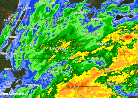 Radar animation from 11 am to 5 pm, April 2nd 2024 |
Wind
PUBLIC INFORMATION STATEMENT
NATIONAL WEATHER SERVICE LA CROSSE WI
808 PM CDT WED APR 3 2024

..HIGHEST WIND REPORTS

LOCATION                     SPEED     TIME/DATE       LAT/LON

..IOWA


..CHICKASAW COUNTY

NEW HAMPTON                  49 MPH    0235 PM 04/03   43.07N/92.46W

..CLAYTON COUNTY

MONONA                       23 MPH    0344 PM 04/03   43.04N/91.39W

..FAYETTE COUNTY

OELWEIN MUNICIPAL AIRPORT    54 MPH    1055 AM 04/03   42.68N/91.97W
HAWKEYE                      48 MPH    0235 PM 04/03   42.96N/91.95W

..FLOYD COUNTY

CHARLES CITY AIRPORT         52 MPH    0135 PM 04/03   43.07N/92.62W
GREENE                       50 MPH    0155 PM 04/03   42.93N/92.81W
2 NE DOUGHERTY               26 MPH    0640 AM 04/03   42.95N/93.01W
CHARLES CITY                 26 MPH    1109 AM 04/03   43.05N/92.67W
NORA SPRINGS                 26 MPH    0215 PM 04/03   43.20N/93.02W
RUDD                         21 MPH    1215 PM 04/03   43.18N/92.83W

..HOWARD COUNTY

SARATOGA                     50 MPH    1120 AM 04/03   43.37N/92.47W
RICEVILLE                    39 MPH    0100 PM 04/03   43.36N/92.48W

..MITCHELL COUNTY

STACYVILLE                   30 MPH    0336 PM 04/03   43.44N/92.78W
OSAGE                        28 MPH    0715 AM 04/03   43.31N/92.84W
SAINT ANSGAR                 21 MPH    1105 AM 04/03   43.39N/92.98W

..WINNESHIEK COUNTY

DECORAH MUNICIPAL AIRPORT    43 MPH    0155 PM 04/03   43.27N/91.72W
DECORAH                      38 MPH    0205 PM 04/03   43.25N/91.70W
CALMAR                       29 MPH    0215 PM 04/03   43.25N/91.82W
DECORAH                      24 MPH    0425 PM 04/03   43.30N/91.79W
1 ENE JACKSON JUNCTION       22 MPH    1239 PM 04/03   43.11N/92.04W

..MINNESOTA


..DODGE COUNTY

U.S.14 - BYRON - MP 200      49 MPH    0215 PM 04/03   44.02N/92.71W
DODGE CENTER AIRPORT         40 MPH    0115 PM 04/03   44.02N/92.82W

..FILLMORE COUNTY

U.S.63 - LE ROY - MP 0.5     50 MPH    0255 PM 04/03   43.51N/92.37W
PRESTON AIRPORT              47 MPH    0315 PM 04/03   43.68N/92.17W
T.H.52 - CANTON - MP 2       44 MPH    1205 PM 04/03   43.52N/91.89W
LANESBORO                    24 MPH    1135 AM 04/03   43.65N/91.84W

..HOUSTON COUNTY

HOKAH                        34 MPH    0425 PM 04/03   43.80N/91.43W
T.H.44 - HOKAH - MP 60       34 MPH    0720 PM 04/03   43.72N/91.44W

..MOWER COUNTY

U.S.218 - LYLE - MP 4        49 MPH    0145 PM 04/03   43.56N/92.95W
I-90 - DEXTER - MP 195       49 MPH    0155 PM 04/03   43.73N/92.68W
AUSTIN MUNICIPAL AIRPORT     43 MPH    1135 AM 04/03   43.67N/92.92W
AUSTIN                       37 MPH    1255 PM 04/03   43.56N/93.02W
LYLE                         37 MPH    0135 PM 04/03   43.51N/92.94W

..OLMSTED COUNTY

ROCHESTER INTERNATIONAL AIRP 59 MPH    0232 PM 04/03   43.90N/92.50W
I-90 - EYOTA - MP 226        52 MPH    0220 PM 04/03   43.96N/92.21W
U.S.63 - STEWARTVILLE - MP 3 46 MPH    0245 PM 04/03   43.90N/92.48W
MAYO HELIPAD                 41 MPH    0255 PM 04/03   44.02N/92.48W
ROCHESTER                    35 MPH    0145 PM 04/03   44.04N/92.44W
BYRON                        33 MPH    1130 AM 04/03   44.03N/92.63W

..WABASHA COUNTY

U.S.63 - LAKE CITY - MP 62.9 51 MPH    0220 PM 04/03   44.38N/92.37W
U.S.61 - KELLOGG - MP 53     43 MPH    1245 PM 04/03   44.28N/91.99W
LAKE CITY                    35 MPH    0230 PM 04/03   44.44N/92.28W
ALTURA                       32 MPH    1015 AM 04/03   44.20N/92.00W

..WINONA COUNTY

I-90 - LA CRESCENT - MP 276. 45 MPH    0735 PM 04/03   43.86N/91.30W
I-90 - RIDGEWAY - MP 261     43 MPH    1110 AM 04/03   43.91N/91.54W
WINONA MUNICIPAL AIRPORT     35 MPH    1135 AM 04/03   44.07N/91.70W
U.S.61 - WINONA              29 MPH    0710 PM 04/03   43.98N/91.43W
LA CRESCENT 4.0 NNW          23 MPH    0425 PM 04/03   43.88N/91.34W

..WISCONSIN


..CLARK COUNTY

GREENWOOD                    29 MPH    1155 AM 04/03   44.72N/90.60W

..CRAWFORD COUNTY

PRAIRIE DU CHIEN  AIRPORT    37 MPH    0415 PM 04/03   43.02N/91.12W
CRAWFORD CO. STH 27 SB 0.25  33 MPH    0500 PM 04/03   43.31N/90.94W
STEUBEN                      31 MPH    0345 PM 04/03   43.21N/91.00W

..GRANT COUNTY

LANCASTER                    40 MPH    1041 AM 04/03   42.83N/90.69W
BOSCOBEL AIRPORT             40 MPH    0406 PM 04/03   43.15N/90.68W
PLATTEVILLE MUNICIPAL AIRPOR 38 MPH    1115 AM 04/03   42.68N/90.43W
PLATTEVILLE                  34 MPH    1150 PM 04/02   42.74N/90.46W
LANCASTER                    31 MPH    0925 AM 04/03   42.83N/90.79W
BOSCOBEL                     28 MPH    0203 PM 04/03   43.15N/90.68W
FENNIMORE                    20 MPH    0910 AM 04/03   42.98N/90.66W
GRANT CO. US 151 NB AT STH 1 19 MPH    0520 AM 04/03   42.52N/90.62W

..JACKSON COUNTY

1 E BLACK RIVER FALLS        32 MPH    0215 AM 04/03   44.30N/90.73W
I-94 EB 0.7 MI SOUTHEAST OF  27 MPH    0549 AM 04/03   44.34N/90.91W
BLACK RIVER FALLS            27 MPH    0305 PM 04/03   44.19N/90.74W
BLACK RIVER FALLS AREA AIRPO 26 MPH    0215 AM 04/03   44.25N/90.85W

..JUNEAU COUNTY

VOLK FIELD                   38 MPH    0315 PM 04/03   43.93N/90.27W
NECEDAH                      35 MPH    0148 PM 04/03   44.03N/90.08W
MAUSTON AIRPORT              30 MPH    0315 AM 04/03   43.83N/90.13W
NEW LISBON                   25 MPH    0145 PM 04/03   43.87N/90.17W

..LA CROSSE COUNTY

LA CROSSE REGIONAL AIRPORT   45 MPH    0258 PM 04/03   43.88N/91.25W
I-90 EB AT USH 53 NB         41 MPH    0231 PM 04/03   43.86N/91.24W
ONALASKA                     34 MPH    0546 PM 04/03   43.89N/91.18W
BURNS                        29 MPH    0413 PM 04/03   43.91N/90.97W
HOLMEN                       26 MPH    0145 PM 04/03   43.96N/91.23W

..MONROE COUNTY

SPARTA/FORT MCCOY AIRPORT    32 MPH    0855 AM 04/03   43.97N/90.73W
TOMAH                        24 MPH    0245 PM 04/03   43.99N/90.67W
MILLSTON                     22 MPH    0100 PM 04/03   44.15N/90.69W

..TAYLOR COUNTY

MEDFORD                      37 MPH    0600 AM 04/03   45.30N/90.30W
MEDFORD AIRPORT              36 MPH    0135 PM 04/03   45.10N/90.30W
3 NE LUBLIN                  34 MPH    1114 PM 04/02   45.11N/90.69W
WESTBORO                     29 MPH    0230 PM 04/03   45.37N/90.31W
GILMAN                       25 MPH    1250 PM 04/03   45.17N/90.82W
STETSONVILLE                 24 MPH    0536 AM 04/03   45.04N/90.34W

..TREMPEALEAU COUNTY

TREMPEALEAU                  28 MPH    1125 AM 04/03   44.07N/91.51W
2 ENE MARSHLAND              25 MPH    1135 AM 04/03   44.09N/91.51W

..VERNON COUNTY

VIROQUA MUNICIPAL AIRPORT    39 MPH    0115 PM 04/03   43.58N/90.90W
LA FARGE                     22 MPH    1145 AM 04/03   43.60N/90.63W

OBSERVATIONS ARE COLLECTED FROM A VARIETY OF SOURCES WITH VARYING
EQUIPMENT AND EXPOSURES. WE THANK ALL VOLUNTEER WEATHER OBSERVERS
FOR THEIR DEDICATION. NOT ALL DATA LISTED ARE CONSIDERED OFFICIAL.
$$
Snow
Public Information Statement
National Weather Service La Crosse WI
951 PM CDT Wed Apr 3 2024

...SNOWFALL REPORTS...

Location                     Amount    Time/Date       Lat/Lon

...Iowa...

...Allamakee County...
Waukon                       7.0 in    0920 AM 04/03   43.27N/91.48W
2 SSE Lansing                7.0 in    0951 AM 04/03   43.34N/91.20W
5 E Elon                     5.5 in    0911 AM 04/03   43.26N/91.23W
Postville 5.5 NE             1.2 in    0700 AM 04/03   43.14N/91.49W

...Chickasaw County...
New Hampton                  1.0 in    0700 AM 04/03   43.06N/92.31W

...Clayton County...
Strawberry Point             4.8 in    0700 AM 04/03   42.69N/91.53W
Monona 0.2 NNW               1.5 in    1000 AM 04/03   43.05N/91.39W

...Fayette County...
Fayette                      2.0 in    0700 AM 04/03   42.88N/91.83W
Oelwein 1 E                  1.1 in    0630 AM 04/03   42.68N/91.88W
Waucoma 1 WNW                1.0 in    0700 AM 04/03   43.06N/92.05W

...Winneshiek County...
7 ENE Decorah                3.5 in    0815 AM 04/03   43.34N/91.64W

...Minnesota...

...Dodge County...
Kasson                       2.3 in    0752 AM 04/03   44.03N/92.75W
Hayfield 0.3 SSE             1.8 in    0630 AM 04/03   43.89N/92.85W
Mantorville 1.9 ESE          1.6 in    0700 AM 04/03   44.05N/92.72W
Kasson 5.7 SE                1.0 in    0900 AM 04/03   43.96N/92.68W

...Fillmore County...
Bratsberg                    6.0 in    1100 AM 04/03   43.74N/91.77W
Mabel                        2.6 in    0700 AM 04/03   43.52N/91.76W
Spring Valley                2.5 in    0716 AM 04/03   43.69N/92.39W
Chatfield 9.0 ESE            2.3 in    0700 AM 04/03   43.79N/92.03W
Wykoff 3.1 NW                2.0 in    0700 AM 04/03   43.74N/92.31W
2 WSW Fillmore               2.0 in    0710 AM 04/03   43.74N/92.31W

...Houston County...
Caledonia                    8.0 in    0245 PM 04/03   43.63N/91.50W
5 SE Houston                 3.0 in    1046 AM 04/03   43.72N/91.50W
Hokah 4 NW                   1.8 in    0700 AM 04/03   43.80N/91.43W
1 ENE Mound Prairie          1.8 in    0700 AM 04/03   43.79N/91.42W

...Mower County...
Adams                        3.0 in    0948 AM 04/03   43.56N/92.72W
Grand Meadow                 2.5 in    0530 AM 04/03   43.71N/92.56W
Waltham 2.0 SE               2.0 in    0800 AM 04/03   43.80N/92.85W
Austin 1.1 ESE               0.7 in    0700 AM 04/03   43.67N/92.95W
Austin 2.4 W                 0.5 in    0650 AM 04/03   43.67N/93.02W
Austin 1.4 S                 0.3 in    0700 AM 04/03   43.65N/92.98W

...Olmsted County...
5 SW Elba                    5.0 in    1122 AM 04/03   44.05N/92.09W
Rochester Intl Airport       3.4 in    0700 AM 04/03   43.93N/92.48W
2 NE Rochester               3.0 in    0530 AM 04/03   44.04N/92.44W
Rochester 3.5 NW             3.0 in    0730 AM 04/03   44.05N/92.53W
Rochester 6.9 NNE            2.9 in    0700 AM 04/03   44.11N/92.43W
Rochester 3.9 ESE            2.6 in    0700 AM 04/03   43.99N/92.41W
Rochester 5.5 N              2.4 in    0930 AM 04/03   44.10N/92.47W
Stewartville 4.3 E           2.0 in    0400 AM 04/03   43.86N/92.40W
2 NNW Rochester              2.0 in    0600 AM 04/03   44.05N/92.49W
3 SW Cummingsville           2.0 in    0715 AM 04/03   43.85N/92.30W
Rochester 4.2 N              1.2 in    0600 AM 04/03   44.08N/92.49W

...Winona County...
Nodine                       6.0 in    0800 AM 04/03   43.91N/91.44W
2 NNW Wilson                 6.0 in    0906 AM 04/03   43.98N/91.71W
Ridgeway                     5.0 in    0719 AM 04/03   43.91N/91.57W
La Crescent 4.0 NNW          3.3 in    0700 AM 04/03   43.88N/91.34W

...Wisconsin...

...Adams County...
Grand Marsh                  8.5 in    0754 AM 04/03   43.89N/89.71W
White Creek                  6.0 in    0722 AM 04/03   43.83N/89.86W
Oxford 4.0 W                 3.5 in    0700 AM 04/03   43.79N/89.64W

...Buffalo County...
Mondovi 12.1 SSE             1.4 in    0714 AM 04/03   44.40N/91.60W

...Clark County...
Thorp                        7.0 in    0753 AM 04/03   44.95N/90.80W
Neillsville                  4.5 in    0719 AM 04/03   44.56N/90.60W
Thorp 10.1 S                 4.2 in    0600 AM 04/03   44.81N/90.82W
Thorp 0.5 NNE                3.4 in    0615 AM 04/03   44.97N/90.80W
Colby 5.9 WSW                3.0 in    0700 PM 04/03   44.87N/90.42W
Owen 1E                      2.0 in    0700 AM 04/03   44.95N/90.55W

...Crawford County...
3 ENE Bell Center            5.0 in    0753 AM 04/03   43.31N/90.77W
1 ENE Prairie Du Chien       5.0 in    1019 AM 04/03   43.05N/91.12W
Eastman                      4.5 in    0236 PM 04/03   43.17N/91.02W
Eastman 2.4 NNE              3.0 in    0700 AM 04/03   43.20N/91.00W
Gays Mills 1.0 NE            1.5 in    0700 AM 04/03   43.33N/90.84W
Bell Center                  1.5 in    0717 AM 04/03   43.29N/90.83W

...Grant County...
Platteville                  6.5 in    0949 AM 04/03   42.74N/90.48W
2 SE Blue River              4.2 in    1110 AM 04/03   43.17N/90.55W
Cassville 7.8 ENE            2.5 in    0700 AM 04/03   42.75N/90.84W
Dickeyville 0.1 SW           2.3 in    0700 AM 04/03   42.62N/90.59W
Muscoda                      2.0 in    0718 AM 04/03   43.19N/90.44W
Muscoda 0.5 WSW              1.3 in    1009 AM 04/03   43.18N/90.44W

...Jackson County...
Melrose 3.6 W                2.8 in    0700 AM 04/03   44.13N/91.07W
4 W Melrose                  2.8 in    0755 AM 04/03   44.13N/91.07W
Black River Falls            1.0 in    0830 AM 04/03   44.29N/90.85W

...La Crosse County...
NWS La Crosse                15.8 in   0100 PM 04/03   43.82N/91.19W
3 SSW Barre Mills            11.5 in   0758 AM 04/03   43.79N/91.15W
6 NNE Stoddard               11.0 in   0757 AM 04/03   43.74N/91.16W
Onalaska 1.9 E               8.5 in    0500 PM 04/03   43.89N/91.18W
La Crosse 10.1 ESE           8.0 in    0900 AM 04/03   43.79N/91.04W
2 WNW Barre Mills            3.5 in    0908 AM 04/03   43.85N/91.15W
Holmen 2 S                   5.0 in    0500 PM 04/03   43.93N/91.25W
Coon Valley 4.5 NNW          2.5 in    0700 AM 04/03   43.76N/91.06W
Onalaska                     2.5 in    0754 AM 04/03   43.88N/91.22W
4 N Holmen                   2.0 in    0759 AM 04/03   44.01N/91.25W
La Crosse 4NNW               1.2 in    0730 AM 04/03   43.87N/91.27W

...Monroe County...
Warrens                      6.0 in    0815 AM 04/03   44.13N/90.50W
Cashton 3 NNW                5.6 in    0737 AM 04/03   43.79N/90.80W
1 N Tomah                    5.3 in    0101 PM 04/03   44.01N/90.50W
Cataract                     4.0 in    0716 AM 04/03   44.09N/90.84W
5 WNW Norwalk                4.0 in    0720 AM 04/03   43.87N/90.71W

...Taylor County...
Medford 0.8 ENE              6.7 in    0700 AM 04/03   45.14N/90.33W
2 N Dorchester               5.4 in    0741 AM 04/03   45.04N/90.34W

...Trempealeau County...
4 NW Stevenstown             5.0 in    0814 AM 04/03   44.07N/91.23W
Ettrick 4.0 WNW              1.8 in    0720 AM 04/03   44.19N/91.34W

...Vernon County...
1 WNW La Farge               11.5 in   1000 AM 04/03   43.58N/90.66W
La Farge                     9.0 in    0700 AM 04/03   43.57N/90.63W
Hillsboro                    8.0 in    0716 AM 04/03   43.65N/90.34W
0.5 E Viroqua                7.6 in    0700 AM 04/03   43.56N/90.88W
Stoddard 4.7 NNE             4.6 in    0700 AM 04/03   43.72N/91.17W
Stoddard 1.5 NE              3.8 in    0730 AM 04/03   43.67N/91.19W
Viroqua 0.8 ESE              3.0 in    0700 AM 04/03   43.55N/90.87W

Observations are collected from a variety of sources with varying
equipment and exposures. We thank all volunteer weather observers
for their dedication. Not all data listed are considered official.

$$
Photos:
Header
 |
 |
 |
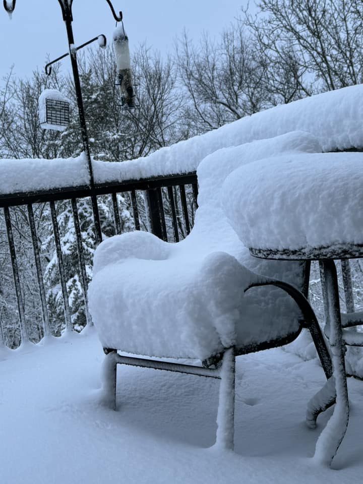 |
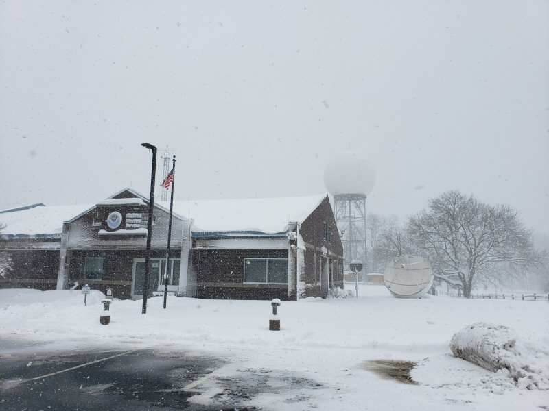
| NWS La Crosse |
N Boscobel on the ridge (Carla Legge) |
N Boscobel on the ridge (Carla Legge) |
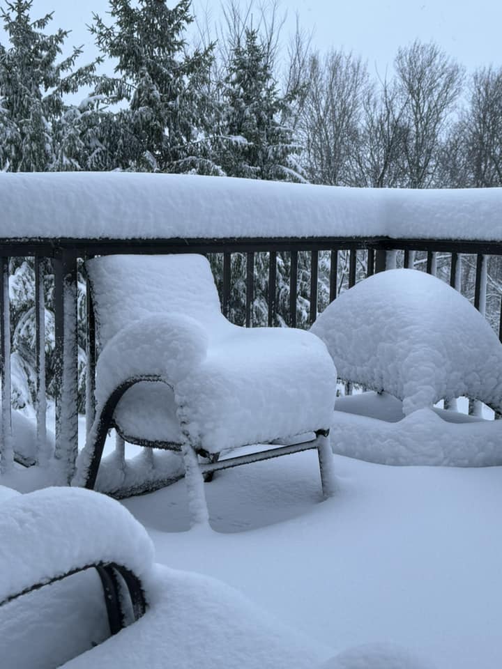
La Crosse HWY 33 Ridgetop (Kim Wetterling-Stoflet) |
 |
 |
 |
 |
| La Crosse HWY 33 Ridgetop (Kim Wetterling-Stoflet) |
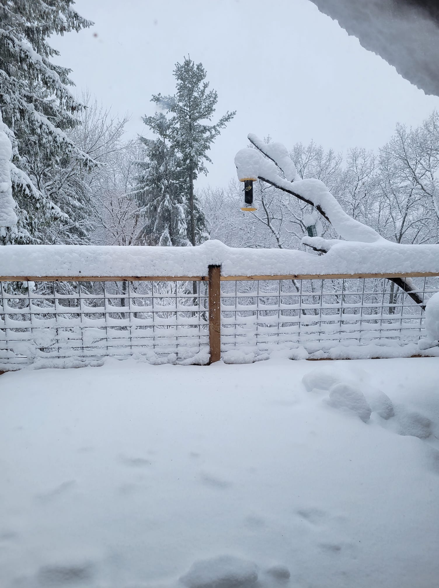
Mt. La Crosse (Mike Furr) |
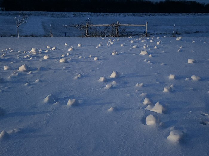
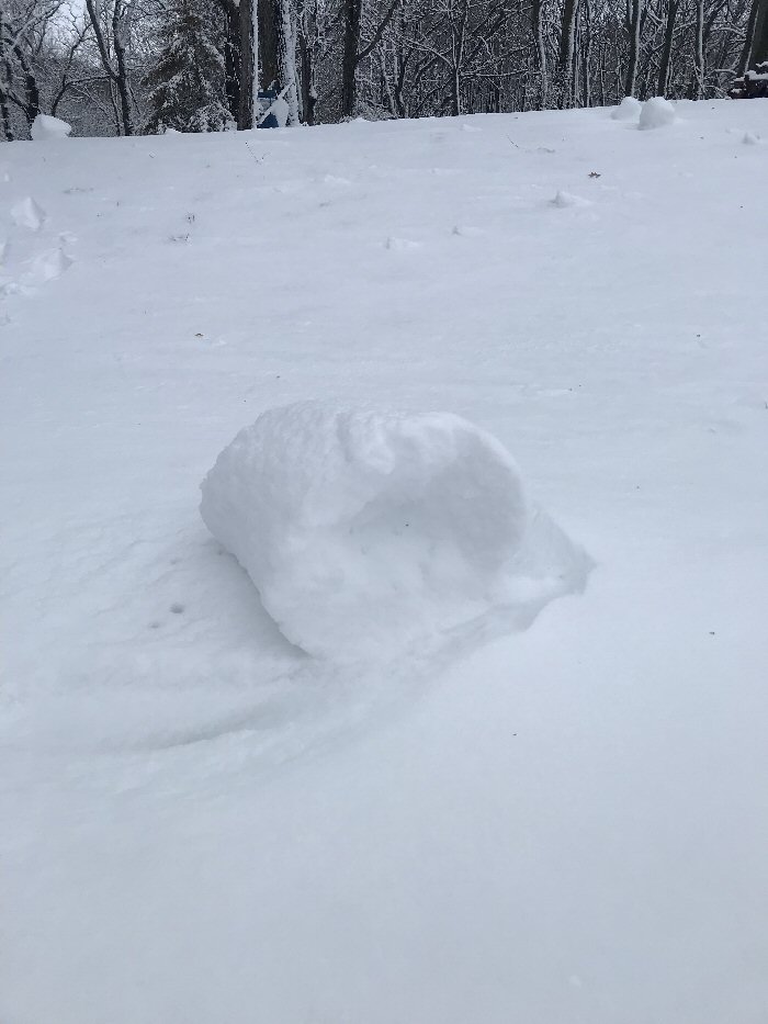
Snow rollers (wind driven rolls of snow) near Whitewater State Park MN (Willis Van Norman) |
Snow roller (wind driven roll of snow) near Whitewater State Park MN (Willis Van Norman) |
 |
Media use of NWS Web News Stories is encouraged! Please acknowledge the NWS as the source of any news information accessed from this site. |
|


 Weather Story
 Weather Map
 Local Radar