Overview
|
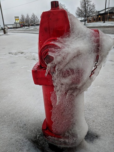
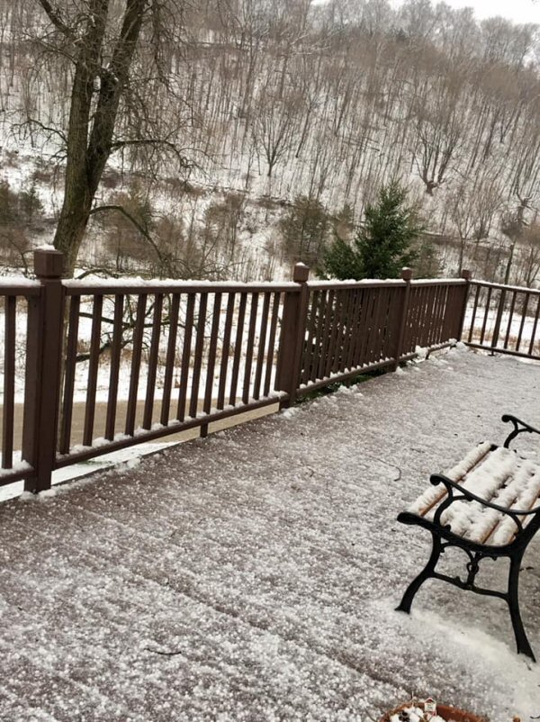
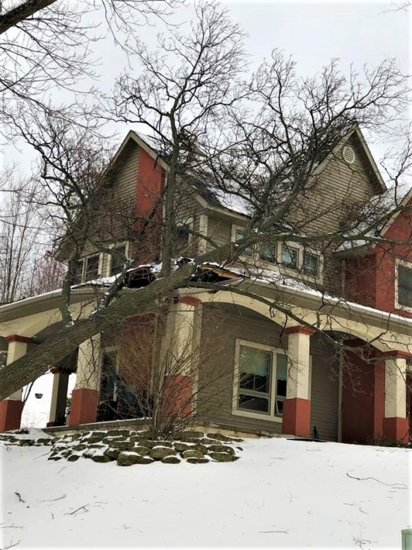
An area of strong low pressure took shape across the Central Plains Wednesday, April 10th, eventually tracking through Minnesota by the morning of April 12th. That system spread heavy snow across many areas later Wednesday, with precipitation changing to a wintry mix of snow, sleet, freezing rain, and just plain rain by Wednesday night into Thursday. Many thunderstorms were also common as Gulf of America moisture spread north into the area, with many areas also seeing a rare phenomenon of "dirty snow" as dust from west Texas was absorbed into this system and deposited with the snow and sleet in our area. Significant snow accumulation of 4 to 10 inches was common for areas closer to and north of Interstate 90, with more of a wintry mess farther south, while mainly rain occurred over much of northeast Iowa into far southwest Wisconsin. In addition to the precipitation, very strong easterly winds of 25 to 35 mph, gusting over 60 mph, brought down numerous trees and power lines, particularly for areas which saw ice accumulation. Travel was quite difficult for many locations, with some road closures due to both slick conditions as well as downed trees and power lines. |
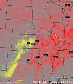
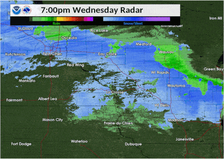 Radar loop of the April 10-11 storm. |
Snow / Sleet / Ice
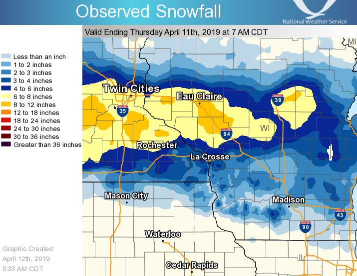
Snow and sleet totals of 4 to 10 inches were common near and north of Interstate 90, with lesser amounts farther south. Below is a look at reported snow/sleet amounts:.
...APRIL 10-11, 2019 SNOWFALL REPORTS...

Location                     Amount    Time/Date       Lat/Lon

...Iowa...

...Allamakee County...
Dorchester                   3.0 in    0735 AM 04/11   43.47N/91.51W
Waukon                       1.0 in    0635 AM 04/11   43.27N/91.48W

...Howard County...
Cresco 1NE                   1.0 in    0700 AM 04/12   43.39N/92.09W

...Mitchell County...
Osage                        0.2 in    0700 AM 04/12   43.28N/92.81W

...Winneshiek County...
7 ENE Decorah                2.5 in    0718 AM 04/12   43.34N/91.64W

...Minnesota...

...Dodge County...
Mantorville 1.9 ESE          4.8 in    0700 AM 04/11   44.05N/92.72W

...Fillmore County...
Wykoff 3.1 NW                5.6 in    0700 AM 04/12   43.74N/92.31W
Chatfield 9.0 ESE            5.6 in    0700 AM 04/11   43.79N/92.03W

...Houston County...
Caledonia 5.4 S              4.0 in    0800 AM 04/11   43.56N/91.51W
Caledonia                    2.0 in    0700 AM 04/12   43.63N/91.50W

...Olmsted County...
2 NE Rochester               11.0 in   0600 AM 04/12   44.04N/92.44W
2 NNW Rochester              7.7 in    0500 AM 04/11   44.05N/92.49W
Rochester 4.7 N              6.4 in    0700 AM 04/11   44.08N/92.48W
Rochester 5.5 N              6.0 in    1000 AM 04/11   44.10N/92.47W
Rochester International Airp 4.6 in    0654 AM 04/12   43.90N/92.50W
Elgin 2SSW                   4.5 in    0700 AM 04/12   44.10N/92.27W
Elba 4.7 SW                  1.5 in    0930 AM 04/11   44.04N/92.09W
1 SSW Oronoco                7.5 in    1046 AM 04/11   44.15N/92.54W

...Wabasha County...
Zumbro Falls 3.5 SSW         9.3 in    0700 AM 04/11   44.24N/92.46W
Wabasha                      7.6 in    0700 AM 04/11   44.38N/92.05W
5 SW Lake City               6.9 in    0927 AM 04/11   44.40N/92.34W
Plainview                    6.0 in    0715 AM 04/11   44.17N/92.17W

...Winona County...
3 ESE Stockton               5.0 in    0720 AM 04/11   44.01N/91.71W
Rollingstone                 4.5 in    1058 AM 04/11   44.10N/91.82W
Winona 1.3 SSW               4.0 in    1005 AM 04/11   44.03N/91.68W
Altura 5w                    4.0 in    0700 AM 04/12   44.06N/92.04W
Winona Dam 5A                3.5 in    0800 AM 04/11   44.09N/91.67W
Pickwick                     3.5 in    0645 AM 04/11   43.98N/91.60W
La Crescent Dam 7            2.0 in    0800 AM 04/11   43.87N/91.31W

...Wisconsin...

...Adams County...
Nekoosa 8.0 SSE              8.0 in    0700 AM 04/11   44.21N/89.85W
8 ENE Friendship             3.1 in    0812 AM 04/11   44.01N/89.66W
Friendship                   3.1 in    0700 AM 04/12   43.98N/89.83W

...Buffalo County...
5 NE Montana                 10.3 in   1108 AM 04/11   44.40N/91.61W
Mondovi                      8.0 in    0843 AM 04/11   44.57N/91.67W
Alma Dam 4                   8.4 in    0800 AM 04/12   44.33N/91.92W
Buffalo                      6.0 in    0720 AM 04/11   44.24N/91.86W

...Clark County...
2 NNE Chili                  8.5 in    0658 AM 04/11   44.66N/90.34W
Neillsville                  7.0 in    0757 AM 04/11   44.56N/90.59W
Withee                       5.0 in    0708 AM 04/11   44.95N/90.60W
2 N Loyal                    5.0 in    0859 AM 04/11   44.77N/90.50W

...Crawford County...
Gays Mills 0.3 SE            2.5 in    0700 AM 04/12   43.32N/90.85W

...Grant County...
Muscoda 0.5 WSW              1.5 in    0830 AM 04/12   43.18N/90.44W
Lancaster 4wsw               0.2 in    0800 AM 04/11   42.83N/90.79W

...Jackson County...
Hixton                       9.5 in    0907 AM 04/11   44.39N/91.01W
Hatfield                     8.5 in    0830 AM 04/11   44.42N/90.73W
Black River Falls 1.7 NNE    8.5 in    0700 AM 04/12   44.32N/90.83W

...Juneau County...
Mauston 1se                  1.0 in    0800 AM 04/12   43.79N/90.06W

...La Crosse County...
La Crosse NWS Office         7.0 in    0700 AM 04/12   43.82N/91.19W
La Crosse Regional Airport   5.9 in    0653 AM 04/12   43.88N/91.25W
La Crosse 4NNW               4.5 in    0730 AM 04/12   43.87N/91.27W
Onalaska                     3.5 in    0715 AM 04/11   43.89N/91.22W

...Monroe County...
Tomah                        5.6 in    0750 AM 04/11   43.99N/90.50W
Warrens 4WSW                 3.9 in    0700 AM 04/11   44.10N/90.59W
Sparta                       3.0 in    0800 AM 04/12   43.94N/90.82W

...Taylor County...
Medford                      8.0 in    0800 AM 04/12   45.13N/90.34W
Lublin                       8.0 in    0545 AM 04/11   45.08N/90.72W
2 N Dorchester               7.0 in    0805 AM 04/11   45.04N/90.34W

...Trempealeau County...
Osseo 0.3 NNW                10.5 in   0648 AM 04/11   44.58N/91.22W
Eleva                        10.0 in   0830 AM 04/11   44.58N/91.47W
Elk Creek                    8.0 in    0638 AM 04/11   44.43N/91.40W
3 SSE Elk Creek              8.0 in    0807 AM 04/11   44.39N/91.38W
2 E Independence             8.0 in    0829 AM 04/11   44.36N/91.37W
Arcadia                      7.0 in    1130 AM 04/11   44.25N/91.49W
Whitehall                    6.0 in    0637 AM 04/11   44.37N/91.31W
Ettrick 4WNW                 5.8 in    0730 AM 04/12   44.19N/91.34W
Trempealeau Dam 6            2.5 in    0700 AM 04/11   44.00N/91.44W

...Vernon County...
Viroqua                      7.4 in    0700 AM 04/12   43.56N/90.88W
Hillsboro 0.5 WSW            4.3 in    0700 AM 04/12   43.65N/90.35W
Stoddard 0.1 SW              2.3 in    0700 AM 04/12   43.66N/91.22W
Westby 3ENE                  2.0 in    0700 AM 04/12   43.67N/90.81W
Viola 3.5 WNW                1.7 in    0800 AM 04/11   43.53N/90.74W

Observations are collected from a variety of sources with varying
equipment and exposures. We thank all volunteer weather observers
for their dedication. Not all data listed are considered official.
Strong Winds
In addition to widespread wintry precipitation, very strong easterly wind gusts of 35 to 60 mph were common across the area. Below is a look at the highest wind gusts reported:
Location                     Speed     Time/Date       Lat/Lon
Oelwein Municipal Airport    64 MPH    1215 PM 04/11   42.67N/91.97W
Decorah Municipal Airport    56 MPH    1155 AM 04/11   43.27N/91.72W
Rochester International Airp 56 MPH    0859 AM 04/11   43.90N/92.50W
Charles City Airport         54 MPH    0955 AM 04/11   43.07N/92.62W
3 N Stewartville             50 MPH    1100 AM 04/11   43.90N/92.48W
Lake City                    49 MPH    1052 AM 04/11   44.32N/92.44W
Prairie Du Chien  Airport    49 MPH    0315 PM 04/11   43.02N/91.12W
1 E Ridgeway                 48 MPH    1205 PM 04/11   43.91N/91.54W
Sparta/Fort McCoy Airport    47 MPH    0415 PM 04/11   43.97N/90.73W
2 ESE Canton                 47 MPH    0320 AM 04/11   43.52N/91.89W
La Crosse Regional Airport   46 MPH    1235 PM 04/11   43.88N/91.25W
Dodge Center                 46 MPH    0415 PM 04/11   44.02N/92.82W
Austin Municipal Airport     45 MPH    0351 PM 04/11   43.67N/92.92W
Platteville Municipal Airpor 45 MPH    0435 PM 04/11   42.68N/90.43W
Volk Field                   45 MPH    1056 AM 04/11   43.92N/90.27W
Boscobel Airport             44 MPH    1006 AM 04/11   43.15N/90.68W
Mayo Helipad                 43 MPH    0516 PM 04/11   44.02N/92.48W
Medford Airport              43 MPH    0555 AM 04/11   45.10N/90.30W
Winona Municipal Airport     43 MPH    1016 AM 04/11   44.07N/91.70W
3 NE Lublin                  42 MPH    0514 PM 04/11   45.11N/90.69W
5 NW Frankville              42 MPH    1132 AM 04/11   43.25N/91.70W
2 N Ionia                    42 MPH    1210 PM 04/11   43.07N/92.46W
Rochester                    41 MPH    0445 PM 04/11   44.08N/92.55W
Riceville                    41 MPH    0416 PM 04/11   43.40N/92.50W
3 SE Waterville              39 MPH    0807 AM 04/11   43.17N/91.24W
Byron                        38 MPH    1131 AM 04/11   44.04N/92.64W
Necedah 1w                   38 MPH    1248 PM 04/11   44.02N/90.08W
Boscobel                     37 MPH    1103 AM 04/11   43.15N/90.68W
1 E Black River Falls        37 MPH    0315 PM 04/11   44.30N/90.73W
Byron                        37 MPH    1041 AM 04/11   44.03N/92.66W
Lake City                    36 MPH    0315 PM 04/11   44.45N/92.27W
Medford                      35 MPH    0515 PM 04/11   45.30N/90.30W
Rochester                    35 MPH    1000 AM 04/11   44.05N/92.45W
1 SSE Kellogg                35 MPH    0130 PM 04/11   44.28N/91.99W

Observations are collected from a variety of sources with varying
equipment and exposures. We thank all volunteer weather observers
for their dedication. Not all data listed are considered official.

$$
Photos:
 |
 |
 |
 |
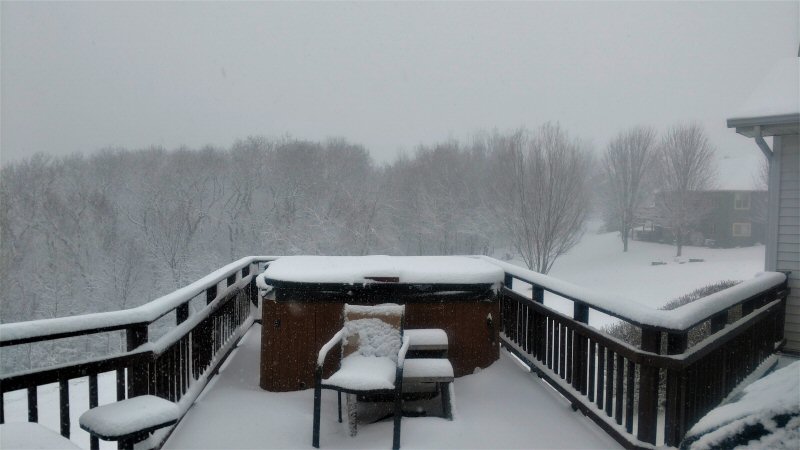
| Heavy snow near St. Joseph, WI (Photo by Dave Lawrence) |
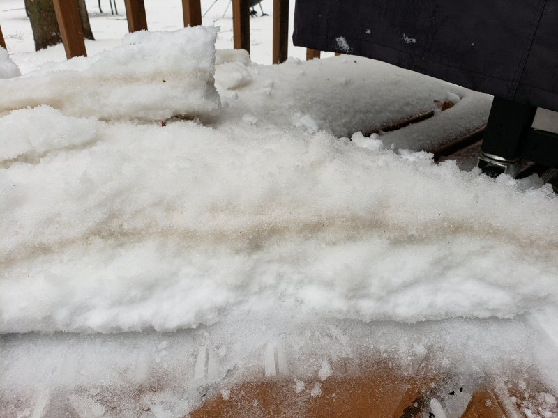
Layer of dust in the snow/sleet (NWS La Crosse) |
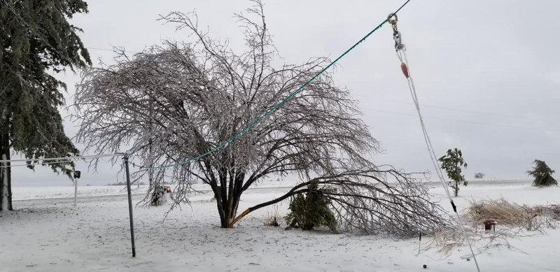
Tree weighed down by ice in Westby, WI (Photo by Ingrid Schroeder) |
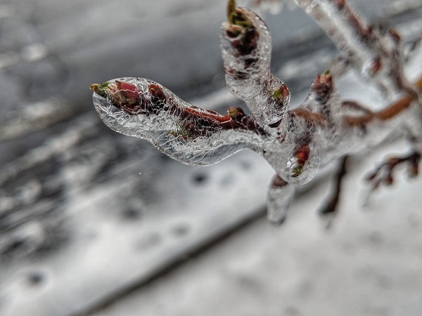
Ice on a tree branch in Viroqua, WI (Photo by Heather McCauley) |
 |
 |
 |
 |
| Wind-driven ice in Viroqua, WI (Photo by Heather McCauley) |
Hail/sleet in Richland Center, WI (Photo by Donna Hostetler) |
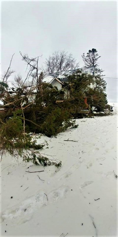
Wind damage in Onalaska, WI (Photo by Amy Zietlow) |
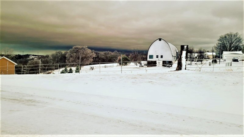
Dark sky (t-storm) near St. Joseph, WI (Photo by Tiffany Lawrence) |
 |
 |
 |
 |
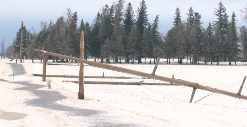
| Heavy wind damage near Grand Meadow, MN (Photo by Unknown) |
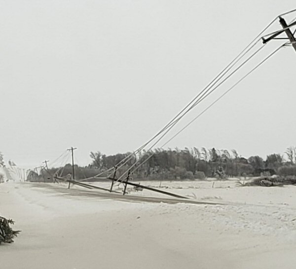
Power line damage near Rose Creek, MN (Photo by Unknown) |
Wind damage in Blair, WI (Photo by Sam Fonstad) |
Animation of dust from Texas arriving across our area, resulting in "dirty" snow in many areas |
 |
Media use of NWS Web News Stories is encouraged! Please acknowledge the NWS as the source of any news information accessed from this site. |
|


 Weather Story
 Weather Map
 Local Radar