Overview
|
A late season storm system brought a swath of significant snow to parts of northeast Iowa, southeast Minnesota, and western into north-central Wisconsin on Easter Sunday, April 12th, 2020. Snow fell heavily at times, with even a few lightning strikes noted, while farther east much of the precipitation was initially in the form of rain before changing to wet snow during the late afternoon and evening hours. Snowfall totals ranged from 1 to as much as 10 inches, with significant travel disruption noted across the region. At the time, it was the 2nd snowiest Easter on record for Rochester, MN with 7.5 inches. In addition strong north to northwest winds behind the storm caused blowing and drifting snow, especially in open country late in the day into the evening hours. Many roads were snow covered and treacherous. |
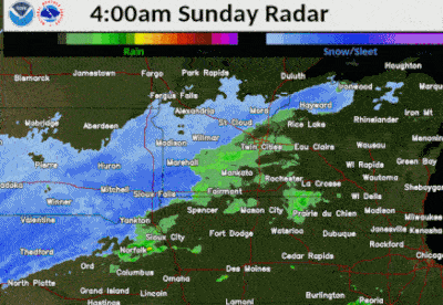 Radar loop of rain and snow on Easter Sunday, April 12th |
Snow
 |
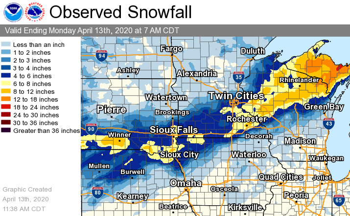 |
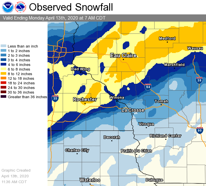
| Snowfall across the local area | Snowfall across the Upper Midwest |
Below is a listing of snowfall reports sent to the National Weather Service in La Crosse.
Location                     Amount    Time/Date       Lat/Lon

...Iowa...

...Chickasaw County...
New Hampton 0.4 SW           0.5 in    0800 AM 04/13   43.06N/92.32W

...Clayton County...
Volga 1NE                    0.1 in    0601 AM 04/13   42.81N/91.52W

...Floyd County...
Nashua 2SW                   0.5 in    0700 AM 04/13   42.94N/92.57W
Charles City                 0.5 in    0700 AM 04/13   43.06N/92.67W

...Howard County...
Cresco 1NE                   0.5 in    0700 AM 04/13   43.39N/92.09W

...Mitchell County...
2 NNE Carpenter              1.8 in    0837 PM 04/12   43.44N/93.00W
St Ansgar                    1.2 in    0630 AM 04/13   43.38N/92.92W
Riceville                    1.0 in    0833 PM 04/12   43.36N/92.56W

...Winneshiek County...
7 ENE Decorah                0.7 in    0900 AM 04/13   43.34N/91.64W
Decorah 4.9SE                0.3 in    0800 AM 04/13   43.26N/91.70W

...Minnesota...

...Dodge County...
Mantorville                  9.0 in    0640 PM 04/12   44.07N/92.76W
Berne                        9.0 in    0508 PM 04/12   44.16N/92.78W
1 NE Kasson                  8.6 in    0600 PM 04/12   44.04N/92.75W
1 W Mantorville              8.0 in    0656 AM 04/13   44.07N/92.78W
Mantorville 1.9 ESE          7.0 in    0800 AM 04/13   44.05N/92.72W

...Fillmore County...
Chatfield 9.0 ESE            2.8 in    0800 AM 04/13   43.79N/92.03W
Wykoff 3.1 NW                2.0 in    0800 PM 04/12   43.74N/92.31W
2 WSW Fillmore               2.0 in    0831 PM 04/12   43.74N/92.31W
Mabel                        0.4 in    0600 AM 04/13   43.52N/91.76W

...Houston County...
Caledonia 5.4 S              2.0 in    0900 AM 04/13   43.56N/91.51W
La Crescent 0.7 N            1.3 in    0830 AM 04/13   43.84N/91.30W
1 NE Mound Prairie           1.3 in    0950 PM 04/12   43.79N/91.43W
Caledonia                    1.1 in    0700 AM 04/13   43.63N/91.50W

...Mower County...
2 NE Lansing                 6.0 in    0815 AM 04/13   43.76N/92.95W
4 WSW Austin                 5.5 in    0857 PM 04/12   43.64N/93.05W
Austin 2.4 W                 5.0 in    0800 AM 04/13   43.67N/93.02W
Austin                       5.0 in    0513 PM 04/12   43.67N/92.97W

...Olmsted County...
Elgin 2SSW                  10.0 in    0700 AM 04/13   44.10N/92.27W
1 SSW Oronoco                9.7 in    0554 PM 04/12   44.15N/92.54W
6 E Douglas                  9.3 in    0622 PM 04/12   44.10N/92.46W
2 NW Marion                  9.1 in    0721 PM 04/12   43.97N/92.38W
Eyota                        9.0 in    0730 PM 04/12   43.99N/92.23W
Rochester                    9.0 in    0727 PM 04/12   44.02N/92.47W
4 SE Douglas                 9.0 in    0320 PM 04/12   44.07N/92.52W
NW Rochester                 8.5 in    0530 AM 04/13   44.08N/92.51W
2 NE Rochester               8.5 in    0700 AM 04/13   44.04N/92.44W
Rochester 4.7 N              8.3 in    0800 AM 04/13   44.08N/92.48W
2 NNW Rochester              8.0 in    0800 AM 04/13   44.05N/92.49W
3 NE Rochester               8.0 in    0830 PM 04/12   44.04N/92.44W
1 SSW Rochester              8.0 in    0746 PM 04/12   44.00N/92.48W
Rochester Intl Airport       7.7 in    0654 AM 04/13   43.90N/92.50W
3 NNW Rochester              7.5 in    0637 PM 04/12   44.06N/92.49W
Byron                        7.5 in    0530 PM 04/12   44.03N/92.65W
Douglas                      7.0 in    0546 PM 04/12   44.11N/92.58W
5 SW Elba                    6.5 in    0730 PM 04/12   44.05N/92.09W
4 NNW Rochester              6.5 in    0526 PM 04/12   44.06N/92.51W
1 ESE Rochester              6.3 in    0530 PM 04/12   44.00N/92.45W
2 S Predmore                 6.0 in    0637 AM 04/13   43.90N/92.34W
2 SE Rochester               6.0 in    0508 PM 04/12   44.00N/92.44W
Elba 4.7 SW                  4.1 in    0630 PM 04/12   44.04N/92.09W
1 S Rochester                4.0 in    0603 PM 04/12   44.00N/92.48W

...Wabasha County...
Elgin                        10.8 in   0746 PM 04/12   44.13N/92.25W
3 NW Wabasha                 10.0 in   1010 PM 04/12   44.40N/92.08W
Wabasha                      10.0 in   0615 PM 04/12   44.37N/92.05W
Theilman 1 SSW               9.6 in    0730 AM 04/13   44.28N/92.19W
Plainview                    8.9 in    0730 PM 04/12   44.17N/92.17W
1 N Wabasha                  8.5 in    0934 PM 04/12   44.38N/92.04W
Theilman                     8.0 in    0656 PM 04/12   44.29N/92.19W
Zumbro Falls                 7.5 in    0639 PM 04/12   44.28N/92.42W
1 NE Wabasha                 6.5 in    0746 PM 04/12   44.38N/92.03W
Zumbro Falls 3.5 SSW         5.0 in    0811 AM 04/13   44.24N/92.46W

...Winona County...
4.2 N Rollingstone           7.0 in    0800 AM 04/13   44.16N/91.81W
Minnesota City               6.7 in    0841 PM 04/12   44.09N/91.75W
Elba                         6.5 in    0457 PM 04/12   44.09N/92.02W
Altura 5w                    5.0 in    0700 AM 04/13   44.06N/92.04W
Winona Dam 5A                4.0 in    0800 AM 04/13   44.09N/91.67W
Minnesota City               4.0 in    0642 PM 04/12   44.09N/91.75W
Utica                        4.0 in    0624 PM 04/12   43.98N/91.96W
3 S Winona                   2.0 in    0645 PM 04/12   44.00N/91.66W

...Wisconsin...

...Adams County...
0.6 W Friendship             1.0 in    0700 AM 04/13   43.98N/89.83W

...Buffalo County...
5 NE Montana                 9.0 in    0828 PM 04/12   44.40N/91.61W
Mondovi                      8.3 in    0812 PM 04/12   44.57N/91.67W
Alma                         8.0 in    0744 PM 04/12   44.32N/91.91W
5 E Gilmanton                7.0 in    0518 PM 04/12   44.46N/91.57W
Alma Dam 4                   5.0 in    0800 AM 04/13   44.33N/91.92W

...Clark County...
Owen 2 N                     11.0 in   0700 AM 04/13   44.98N/90.55W
5 W Withee                   9.6 in    0556 PM 04/12   44.96N/90.70W
Withee                       9.5 in    0518 PM 04/12   44.95N/90.60W
Loyal                        8.0 in    0952 PM 04/12   44.74N/90.50W
Neillsville 4NNE             6.3 in    0723 PM 04/12   44.61N/90.56W
Colby 5.9 WSW                6.0 in    0800 PM 04/12   44.87N/90.42W
Neillsville                  6.0 in    0533 PM 04/12   44.56N/90.59W
2 N Dorchester               6.0 in    0500 PM 04/12   45.03N/90.33W

...Crawford County...
1 S De Soto                  0.8 in    0746 AM 04/13   43.41N/91.19W

...Jackson County...
Black River Falls 1.7 NNE    4.6 in    0800 AM 04/13   44.32N/90.83W
Hatfield                     3.0 in    0842 PM 04/12   44.41N/90.73W

...Juneau County...
1.0 E Mauston                1.0 in    0800 AM 04/13   43.79N/90.06W

...La Crosse County...
4 NE New Amsterdam           3.0 in    0700 AM 04/13   44.03N/91.27W
NWS La Crosse                2.4 in    0700 AM 04/13   43.82N/91.19W
1 NNW Onalaska               2.0 in    0923 PM 04/12   43.90N/91.23W
Holmen 2S                    2.0 in    0700 AM 04/12   43.93N/91.24W
La Crosse Regional Airport   1.7 in    0653 AM 04/13   43.88N/91.25W
La Crosse 4.4 SSE            1.0 in    0800 AM 04/13   43.77N/91.21W
West Salem                   0.9 in    0700 AM 04/13   43.90N/91.09W

...Monroe County...
0.5 SW Sparta                2.0 in    0800 AM 04/13   43.94N/90.82W
Warrens 4.7 WSW              1.8 in    0800 AM 04/13   44.10N/90.59W

...Taylor County...
Medford                     10.0 in    0612 PM 04/12   45.14N/90.35W
Dorchester 2N                8.5 in    0700 AM 04/13
Lublin                       6.5 in    0744 PM 04/12   45.08N/90.72W

...Trempealeau County...
Independence 3NE             7.0 in    0825 AM 04/13   44.39N/91.39W
Arcadia                      7.0 in    0605 AM 04/13   44.25N/91.49W
Ettrick 4.0 WNW              5.3 in    0815 AM 04/13   44.19N/91.34W
Blair                        5.0 in    0953 PM 04/12   44.30N/91.23W
Ettrick 3.2 NE               3.8 in    0830 AM 04/13   44.20N/91.23W
Galesville 2WSW              2.6 in    0700 AM 04/13   44.07N/91.39W
Trempealeau Dam 6            1.0 in    0800 AM 04/13   44.00N/91.44W

...Vernon County...
Genoa                        1.0 in    0820 PM 04/12   43.57N/91.23W
Stoddard 4.7 NNE             0.9 in    0800 AM 04/13   43.72N/91.17W
0.5 E Viroqua                0.7 in    0700 AM 04/13   43.56N/90.88W
La Farge                     0.5 in    0700 AM 04/13   43.57N/90.63W
Hillsboro 2 SW               0.3 in    0700 AM 04/13   43.63N/90.38W

Observations are collected from a variety of sources with varying
equipment and exposures. We thank all volunteer weather observers
for their dedication. Not all data listed are considered official.
Graphics / Photos:
Photos coming soon. If you have any, send them to us on Facebook or Twitter.
 |
 |
 |
 |
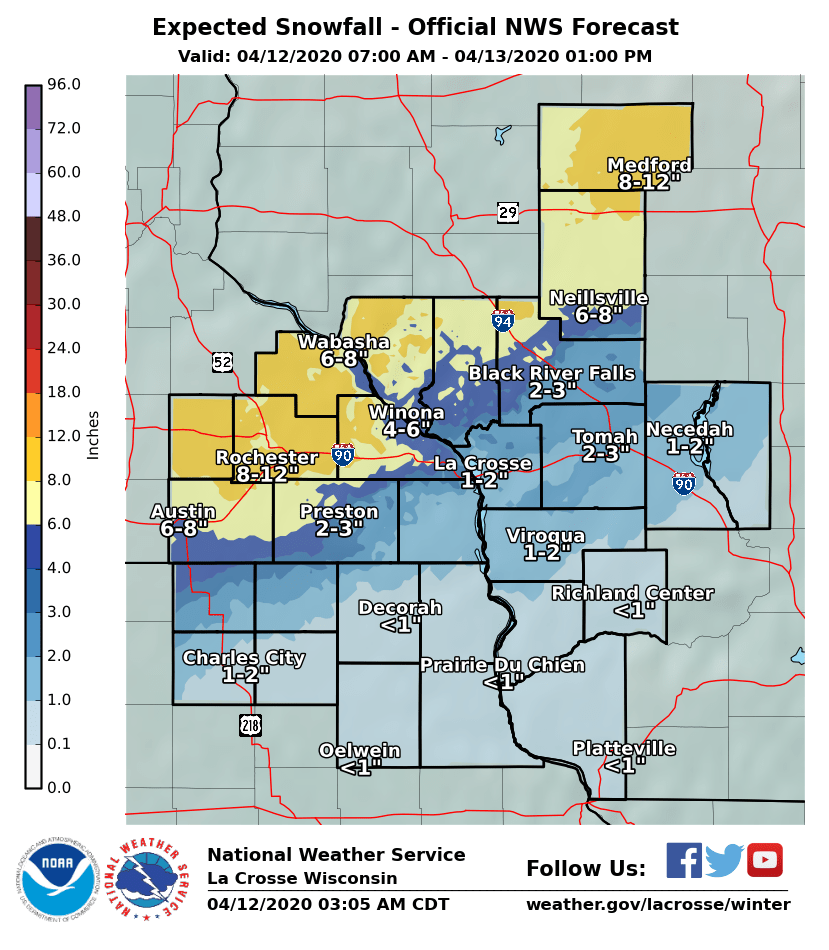
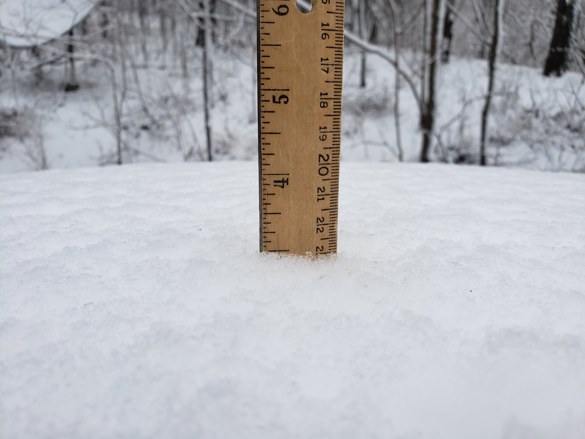
| Predicted snowfall for April 12, 2020 | Snowfall in northern La Crosse Co., WI (Photo by M.Kurz) |
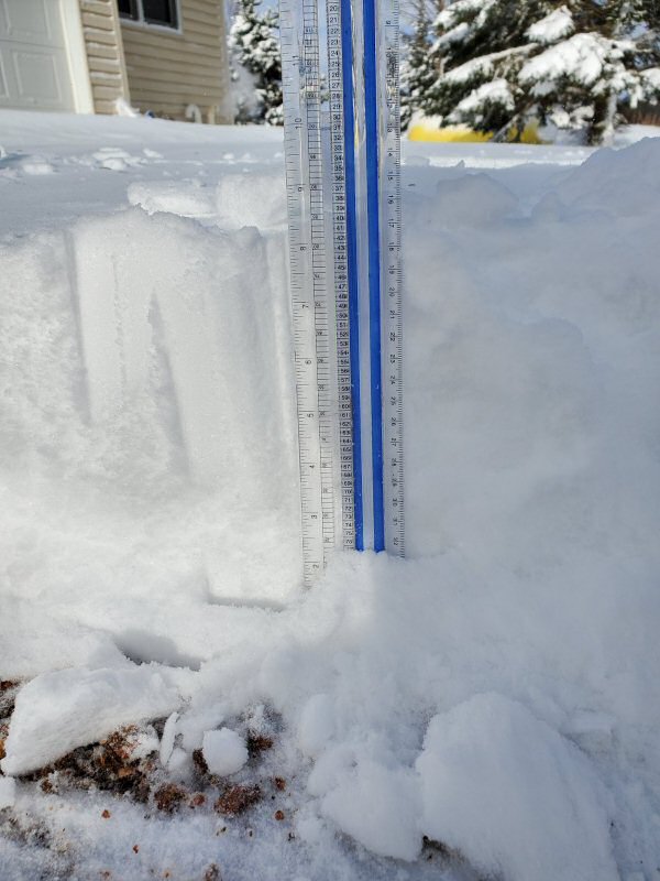
Snowfall 2 miles north of Dorchester, WI (Photo by D.Schumacher) |
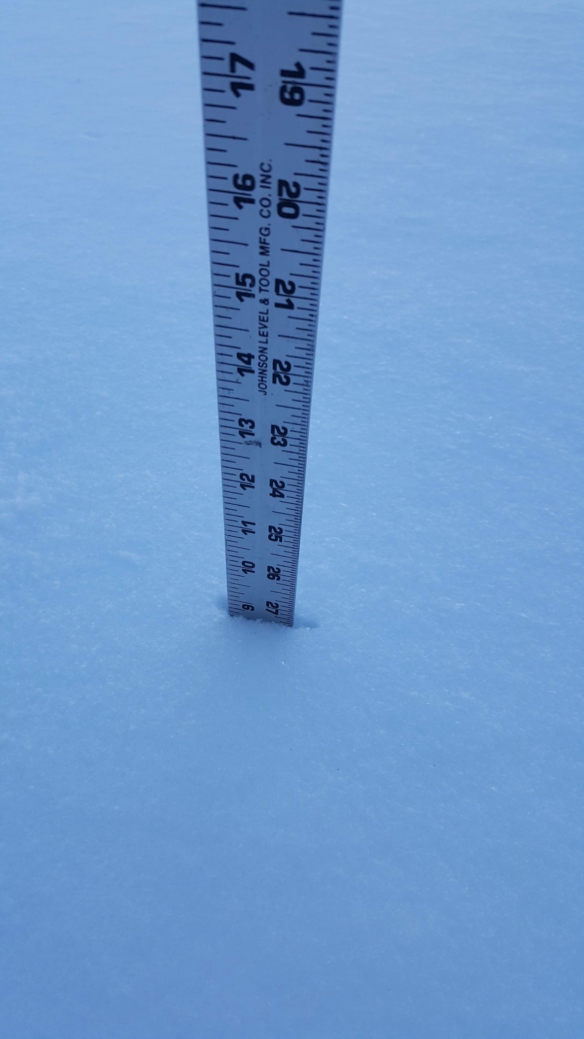
Snowfall northwest Rochester, MN (Photo by W0MN via Twitter) |
 |
 |
||
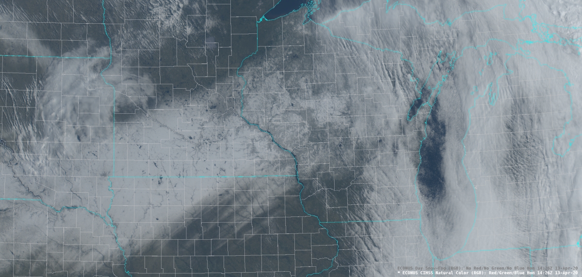
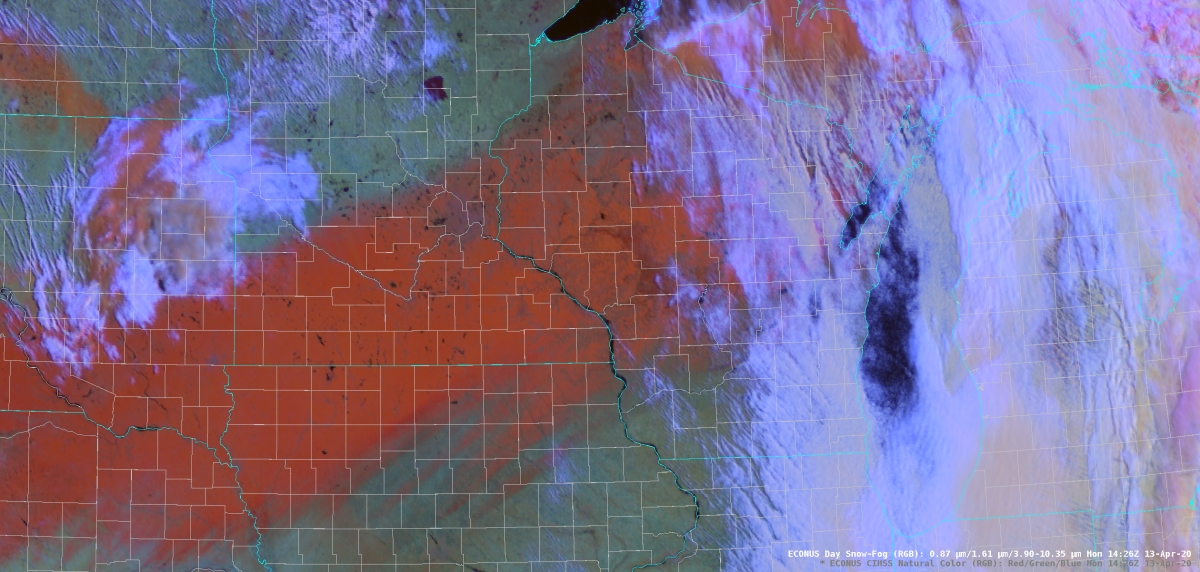
| Fallen Snow Band via GOES-16 Natural Color Product | Fallen Snow Band via GOES-16 Day Snow-Fog Product (Snow in Red) |
Snowfall Records:
...Cooperative Snowfall Records for April 12-13...

   Location          New Record      Old Record
   --------          ----------      ----------
Owen 1E, WI         11.0 inches  4.0 inches in 1962
Elgin 2SSW, MN      10.0 inches  3.5 inches in 1952
Theilman, 1SSW MN    9.6 inches  3.4 inches in 1962
Wabasha MN           7.8 inches  0.6 inches in 1991
Rochester AP 2NE MN  7.7 inches  0.4 inches in 2000
Minnesota City MN    7.0 inches  5.0 inches in 1962
Medford, MN          7.0 inches  3.0 inches in 1952
Lake City, MN        6.0 inches  2.0 inches in 1962
Altura 5W MN         5.0 inches  0.5 inches in 2013
Alma Dam 4 WI        5.0 inches  4.0 inches in 1962
Black River Falls WI 3.7 inches  0.1 inches in 2013
Grand Meadow MN      3.0 inches  3.0 inches in 1952
Spring Valley MN     2.0 inches  0.5 inches in 2013
Friendship WI        1.0 inches  0.6 inches in 2013

Snowfall Records from 7 AM April 12 to 7 AM April 13
 |
Media use of NWS Web News Stories is encouraged! Please acknowledge the NWS as the source of any news information accessed from this site. |
|


 Weather Story
 Weather Map
 Local Radar