Overview
|
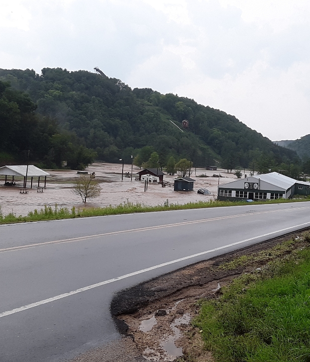
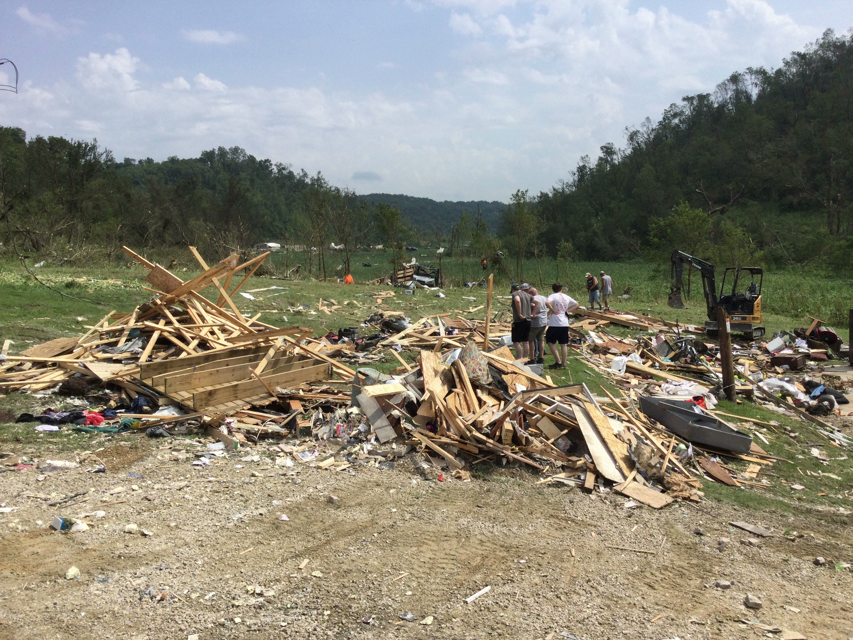
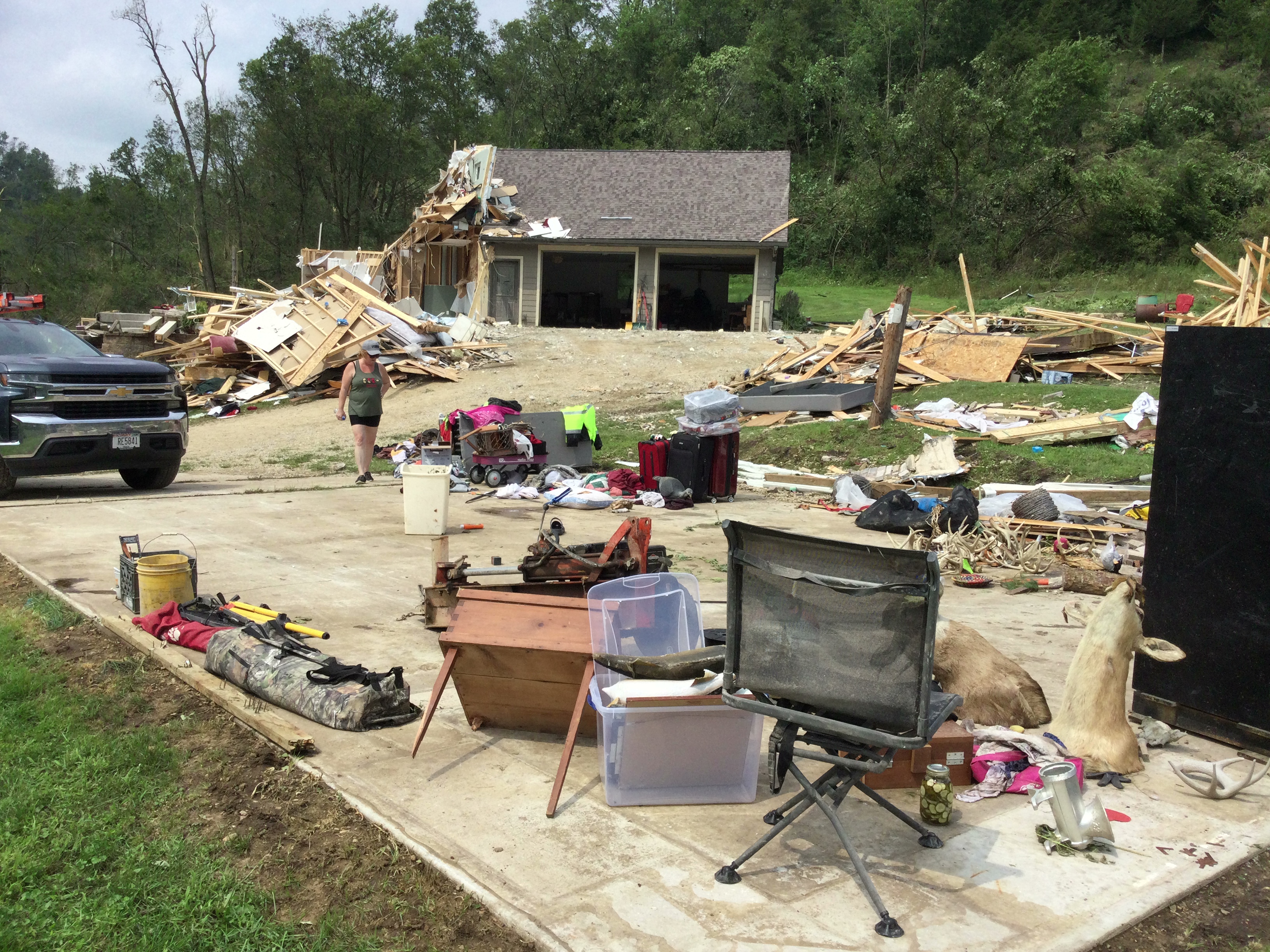
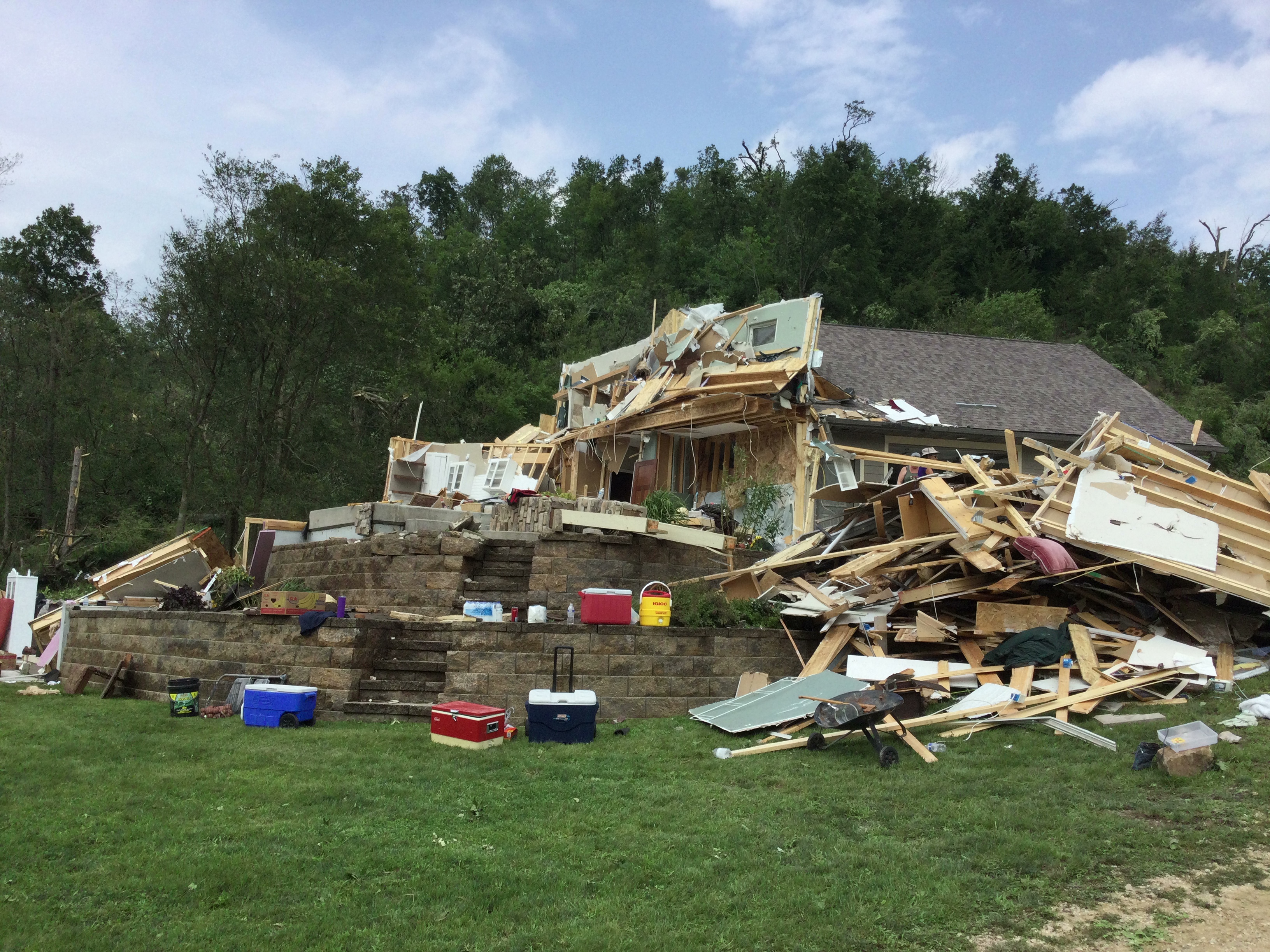
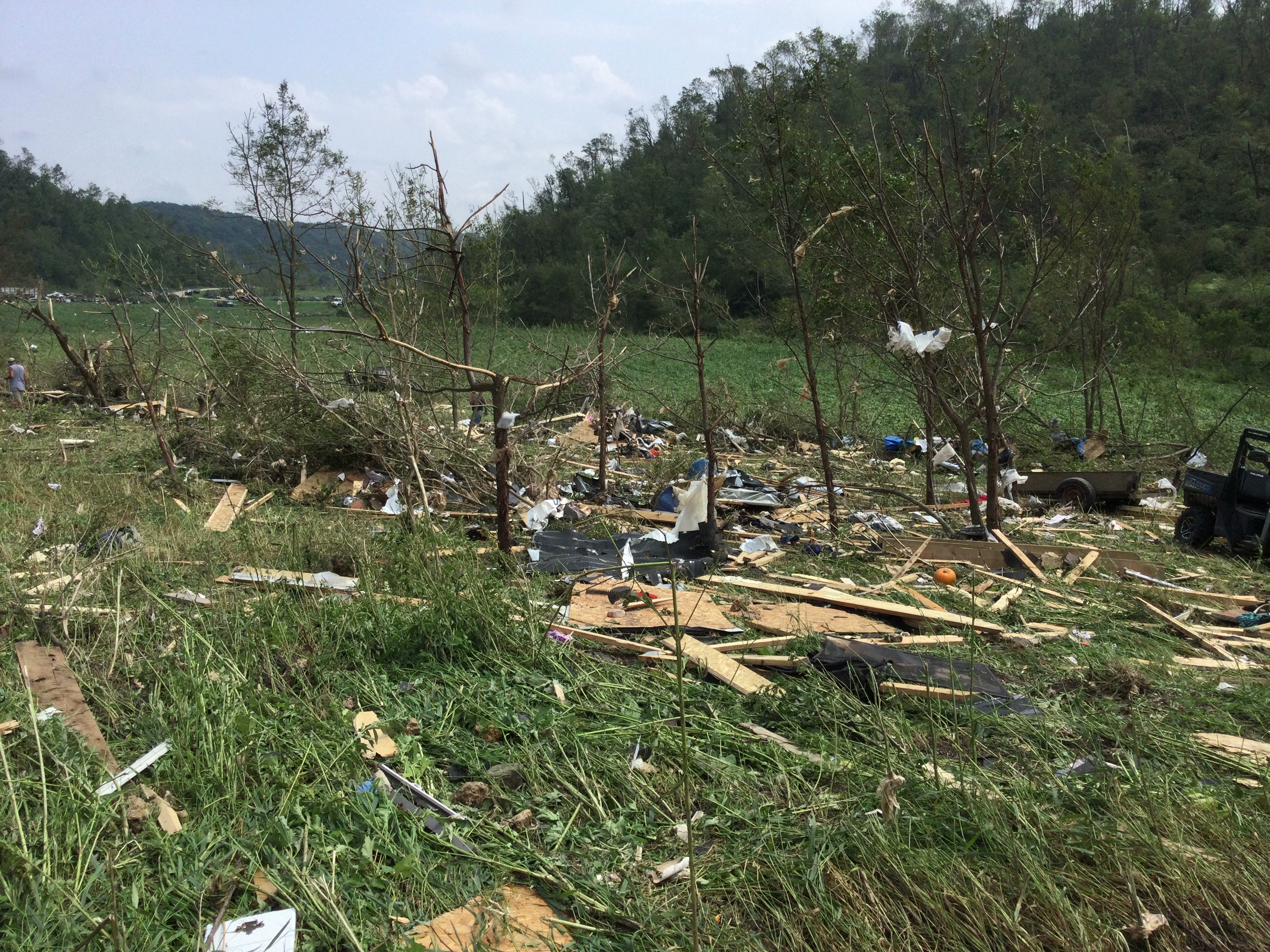
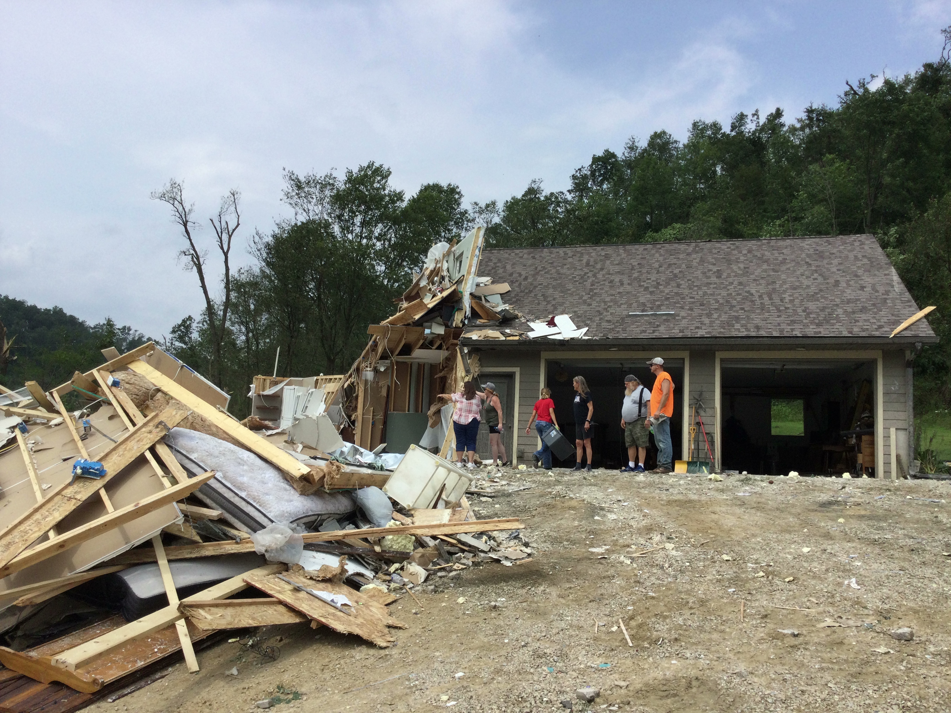
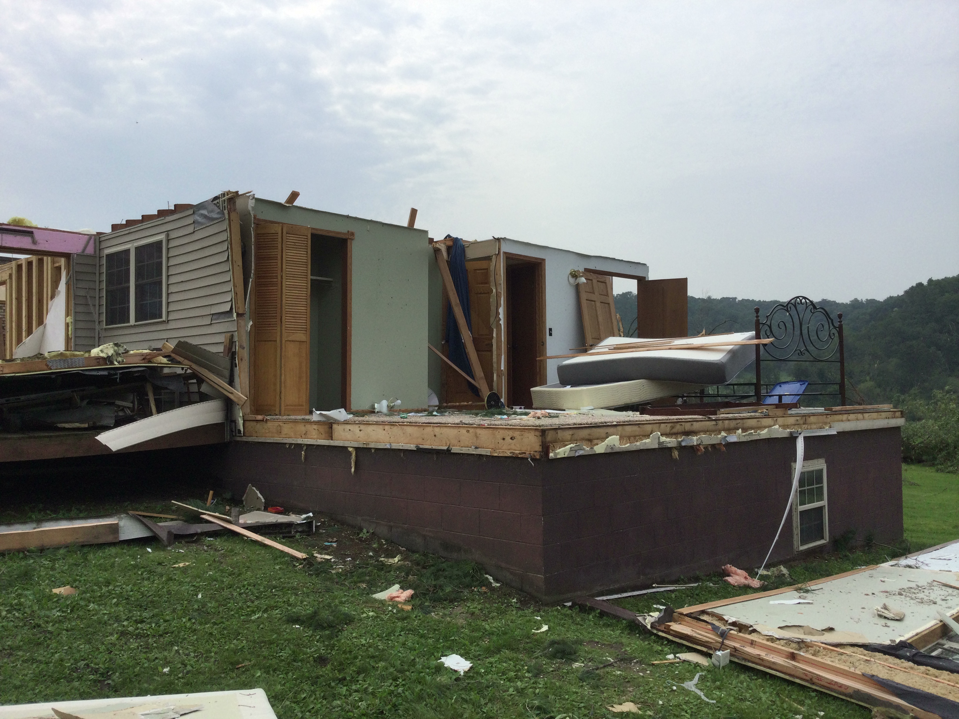
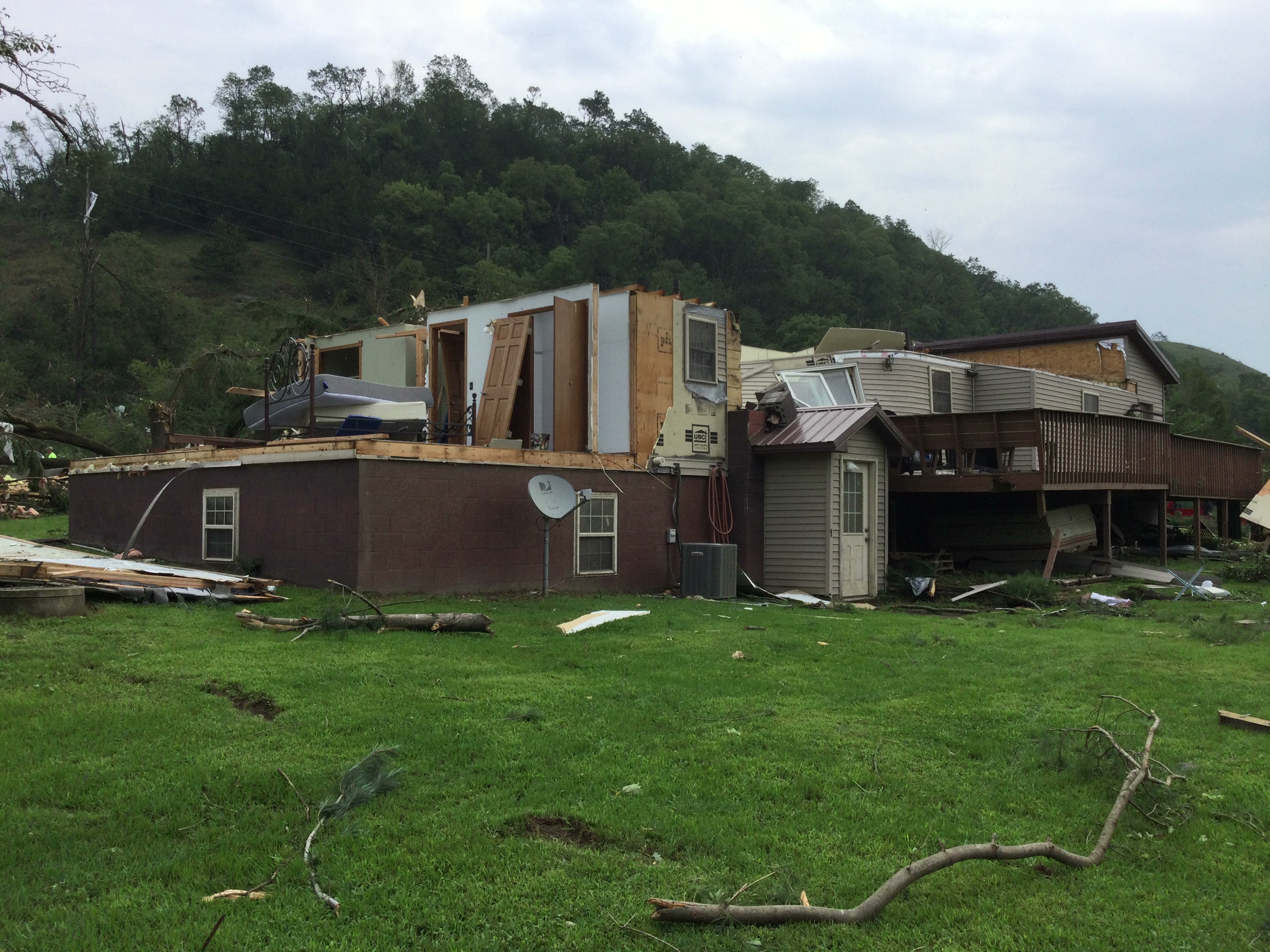
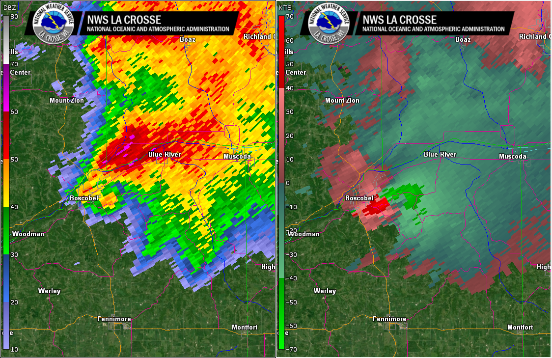
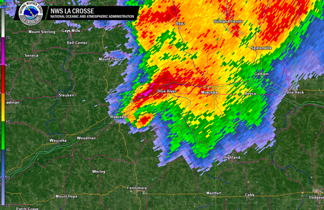
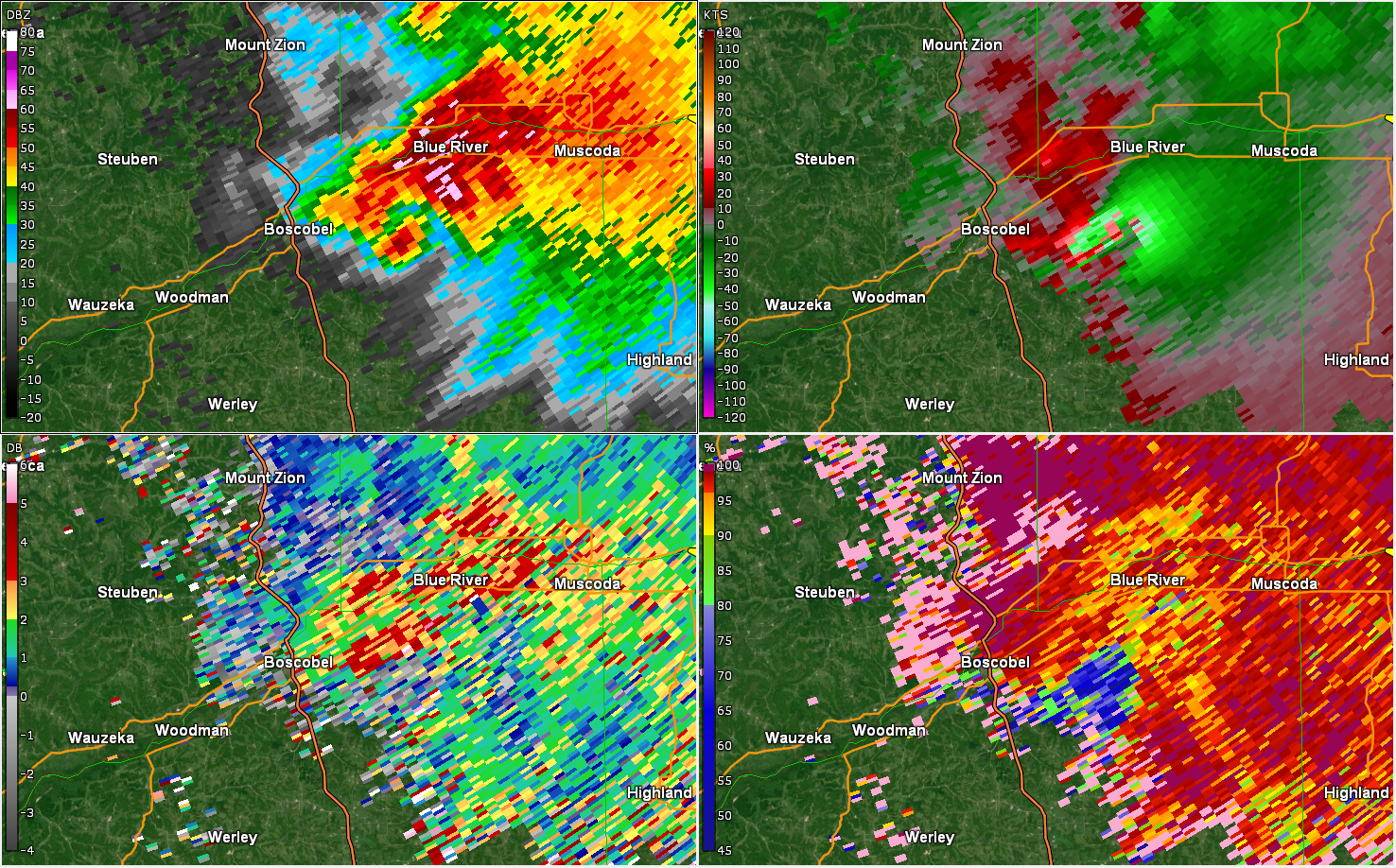
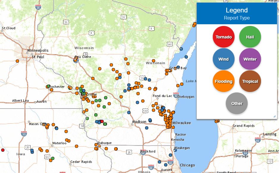
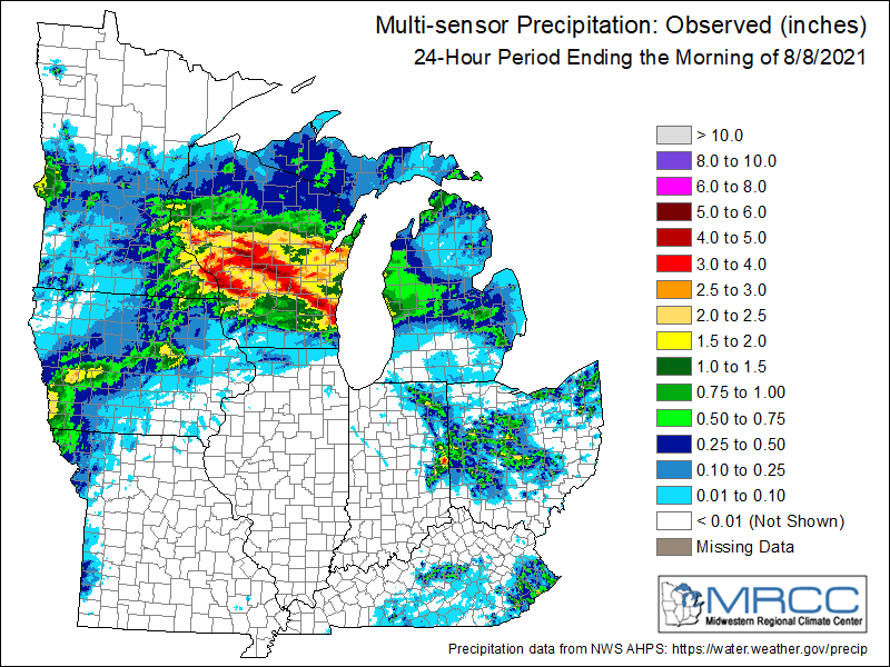
Widespread thunderstorms moved across the region on Saturday, August 7th 2021. Storms were very efficient rainfall producers, including rainfall rates in excess of 2" per hour at times. A swath of 4 to 6 inches fell from near Winona, MN east southeast across La Crosse, southeast Monroe and northern Vernon counties in Wisconsin. This resulted in widespread flooding, especially in the city of La Crosse where street flooding stranded numerous vehicles. An additional band of 3 to 5 inches came a few hours later, running from southern Clark to across Adams and Juneau counties in central Wisconsin. Some locations received record rainfall for the day, with even some record 2-3 day totals. In southwest Wisconsin, a strong tornado (EF-3) touched down near Boscobel, destroying or damaging several houses and outbuildings as it tracked east for just over 10 miles. The tornado lasted for 27 minutes and started near the southern edge of Boscobel. No injuries were reported. |
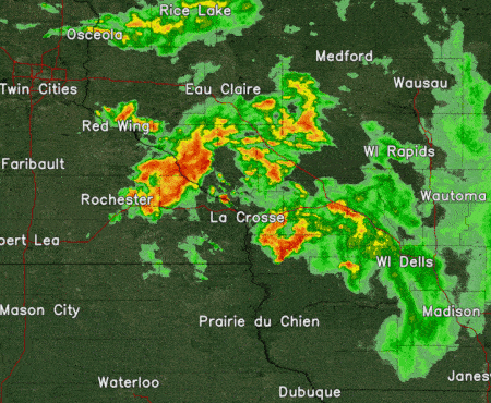 Radar loop from 1 to 7 p.m. August 7, 2021 |
Tornado:
|
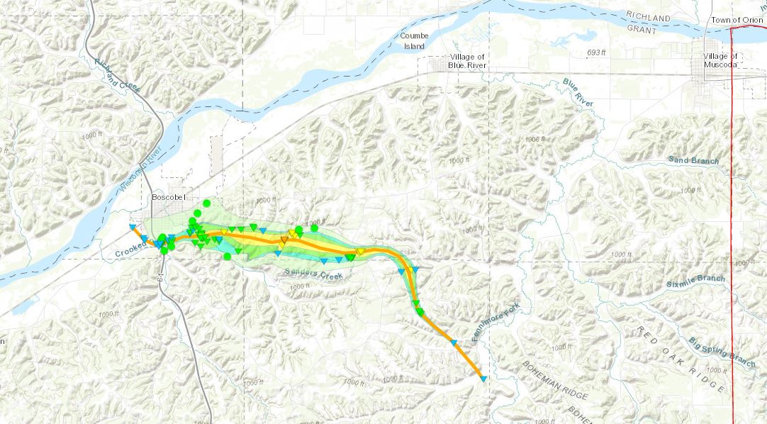
Tornado - Boscobel, WI
|
||||||||||||||||
The Enhanced Fujita (EF) Scale classifies tornadoes into the following categories:
| EF0 Weak 65-85 mph |
EF1 Moderate 86-110 mph |
EF2 Significant 111-135 mph |
EF3 Severe 136-165 mph |
EF4 Extreme 166-200 mph |
EF5 Catastrophic 200+ mph |
 |
|||||
Flooding
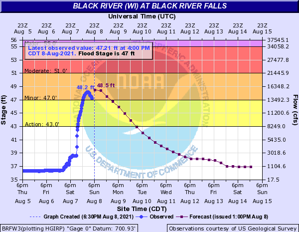
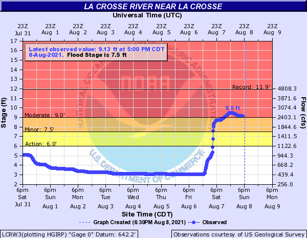
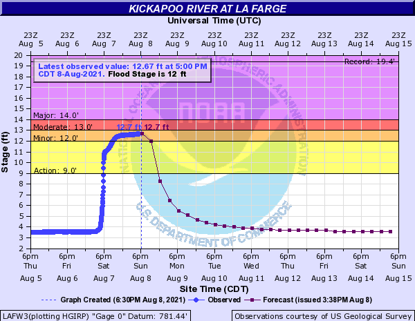
Heavy rainfall resulted in significant street flooding, mudslides, and rises on some rivers and streams. Especially hard hit was the Kickapoo river.
Hydrographs
 |
 |
 |
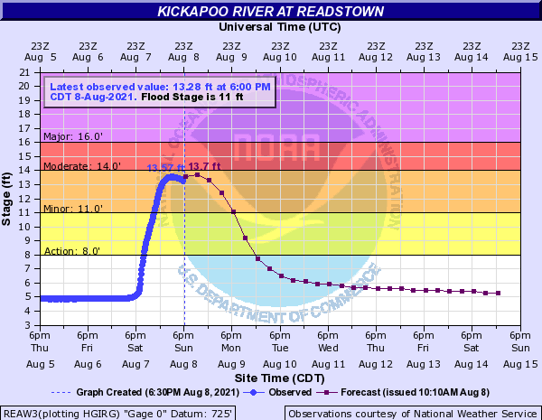 |
| Black River at Black River Falls, WI | La Crosse River at La Crosse, WI | Kickapoo River at La Farge, WI | Kickapoo River at Readstown, WI |
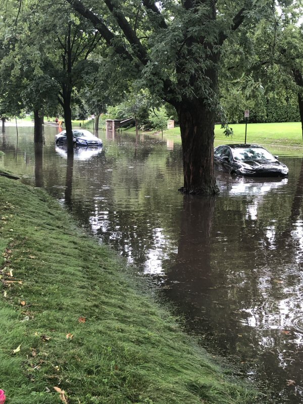
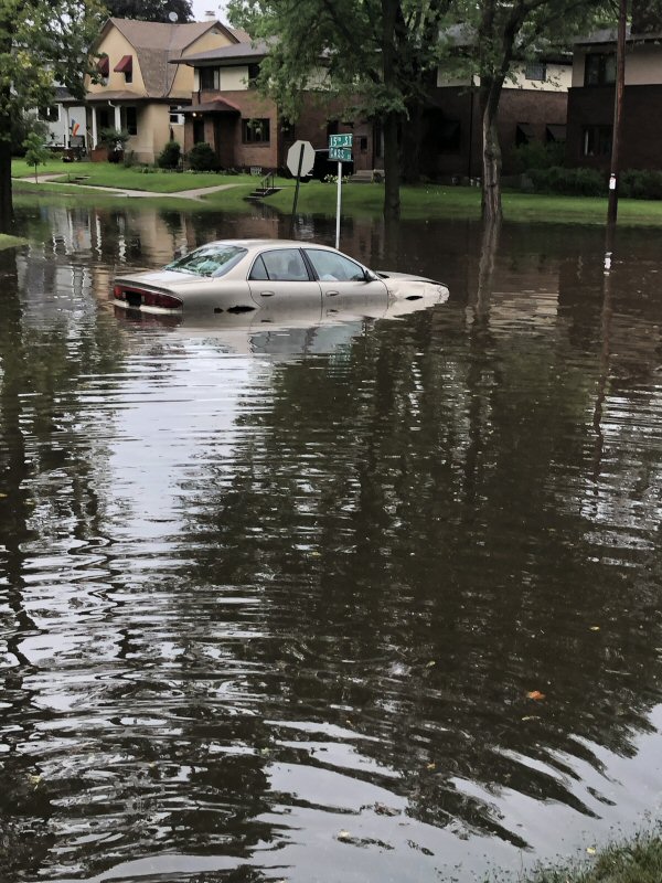
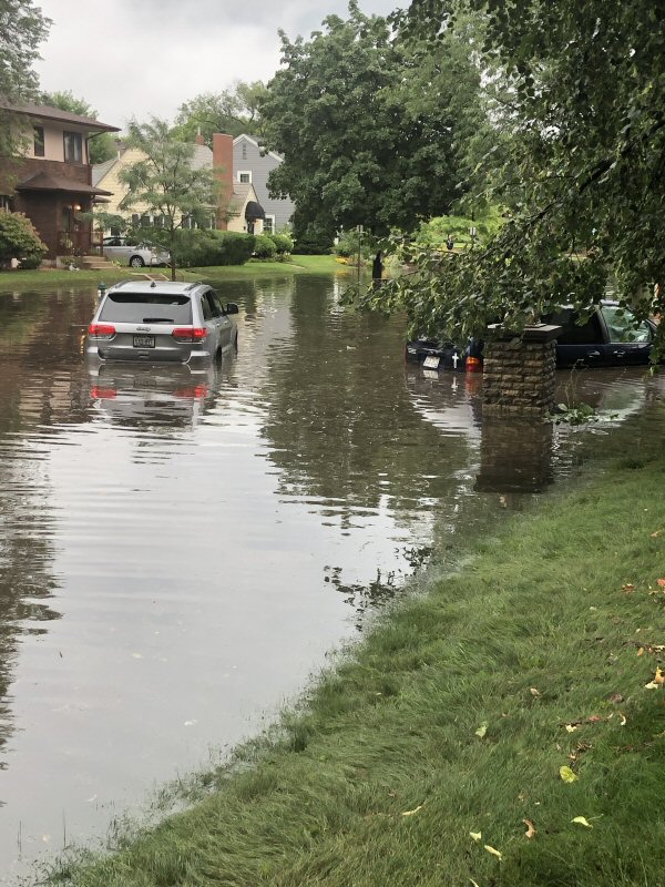
Photos
 |
 |
 |
 |
| Flooding on Cass St, La Crosse, WI [credit: Stacy Simon] |
Flooding on Cass St, La Crosse, WI [credit: Stacy Simon] |
Flooding on Cass St, La Crosse, WI [credit: Stacy Simon] |
Timber Coulee [B Larson - Vernon Co EM:] |
Photos:
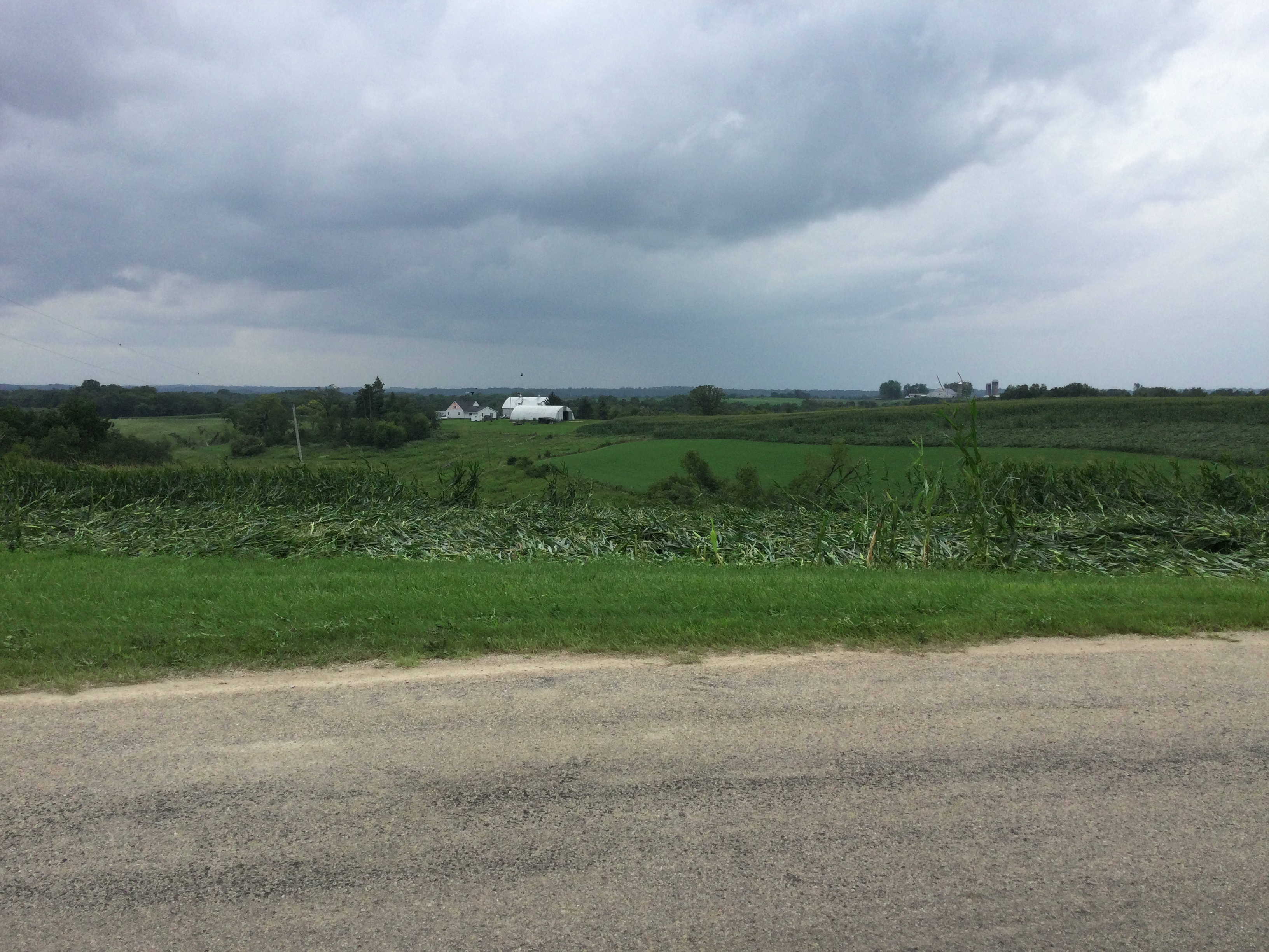
NWS damage survey from Boscobel, WI area:
 |
 |
 |
 |
| Damaged home east-southeast of Boscobel, WI (NWS Survey) |
Damaged home east-southeast of Boscobel, WI (NWS Survey) |
Damaged home east-southeast of Boscobel, WI (NWS Survey) |
Damaged home east-southeast of Boscobel, WI (NWS Survey) |
 |
 |
 |
 |
| Damaged home east-southeast of Boscobel, WI (NWS Survey) |
Damaged home east-southeast of Boscobel, WI (NWS Survey) |
Damaged home east-southeast of Boscobel, WI (NWS Survey) |
Damaged home east-southeast of Boscobel, WI (NWS Survey) |
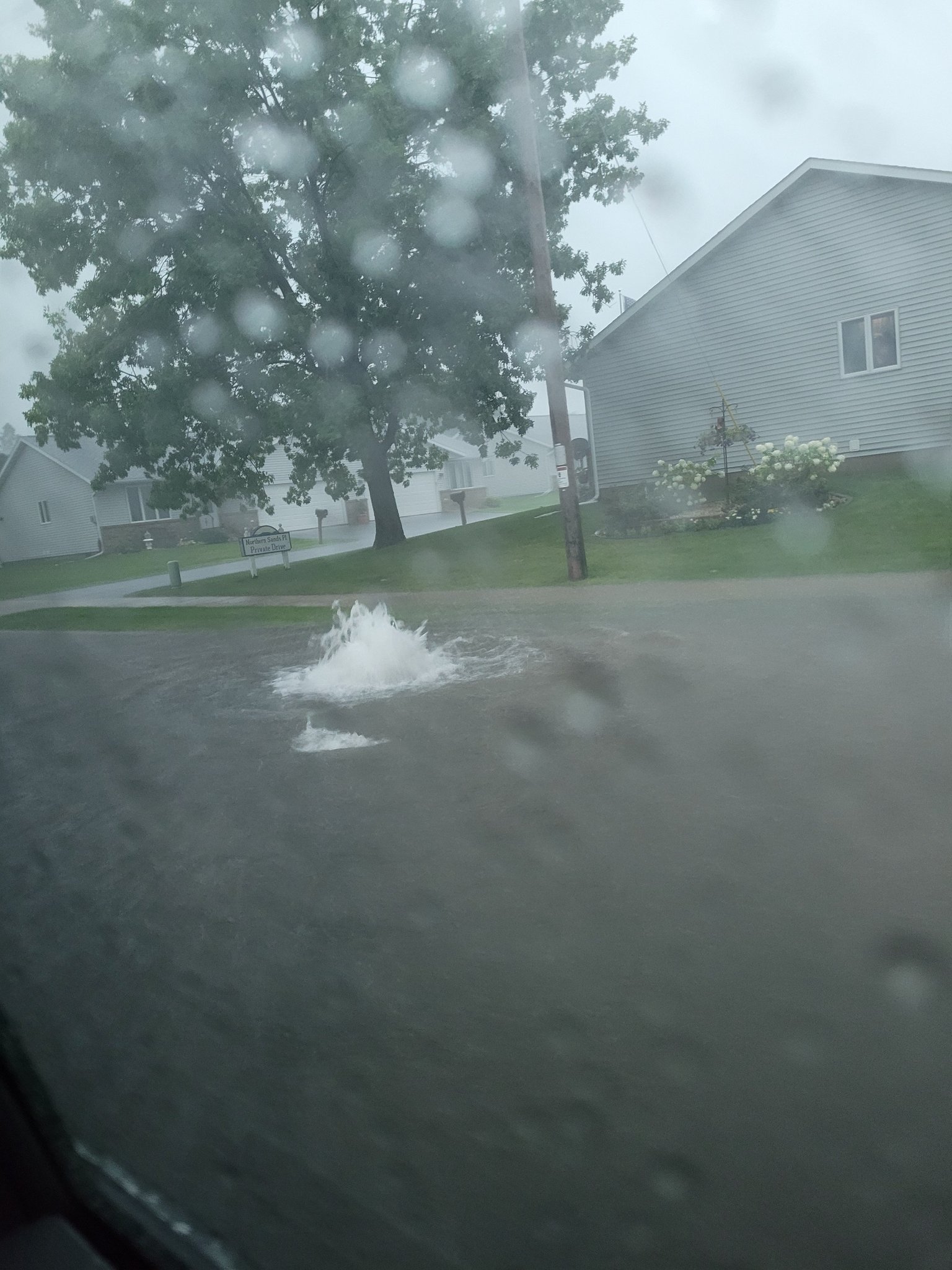
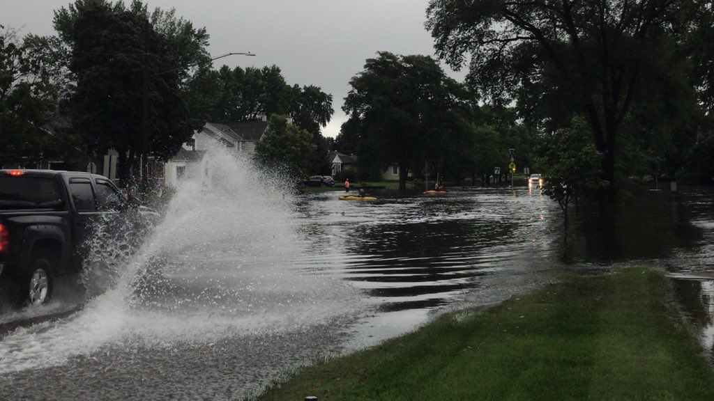
Street Flooding:
 |
 |
||
| Street flooding in Onalaska, WI (Courtesy of Bill Anderson) |
Street flooding in La Crosse, WI (Courtesy of Lauren Gourley) |
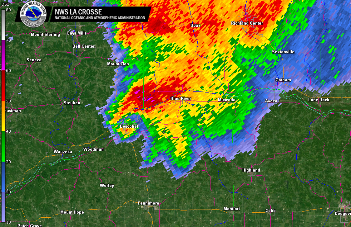
Radar:
 |
 |
 |
 |
| KARX radar 4:29pm | KARX radar 4:37pm | KARX radar 4:40pm | KARX radar 4:43pm |
Storm Reports
..TIME... ...EVENT... ...CITY LOCATION... ...LAT.LON...
..DATE... ....MAG.... ..COUNTY LOCATION..ST.. ...SOURCE....
..REMARKS..
1045 AM Hail 5 E Douglas 44.10N 92.48W
08/07/2021 E1.00 inch Olmsted MN Emergency Mngr
Short period of quarter sized hail on the
far north side of Rochester.
1052 AM Hail 5 E Douglas 44.10N 92.47W
08/07/2021 U0.75 inch Olmsted MN Public
Report from mPING: Dime (0.75 in.).
1131 AM Hail 5 NW Eastman 43.23N 91.05W
08/07/2021 U0.75 inch Crawford WI Public
Report from mPING: Dime (0.75 in.).
0127 PM Flood 2 SE Goodview 44.04N 91.69W
08/07/2021 Winona MN Public
Report from mPING: River/Creek overflowing;
Cropland/Yard/Basement Flooding.
0135 PM Flood Goodview 44.07N 91.71W
08/07/2021 Winona MN Emergency Mngr
Street flooding occurring in Goodview and
the west side of Winona.
0149 PM Hail Yuba 43.54N 90.43W
08/07/2021 E1.00 inch Richland WI Public
Public report photo via WKBT.
0213 PM Hail 1 W Holmen 43.96N 91.28W
08/07/2021 U0.75 inch La Crosse WI Public
Report from mPING: Dime (0.75 in.).
0216 PM Hail 4 NNE New Amsterdam 44.03N 91.29W
08/07/2021 E0.88 inch La Crosse WI NWS Employee
Strong winds with branches down.
0219 PM Hail 2 N Onalaska 43.91N 91.22W
08/07/2021 U1.00 inch La Crosse WI Public
Report from mPING: Quarter (1.00 in.).
0219 PM Hail 1 NW Onalaska 43.90N 91.23W
08/07/2021 U0.75 inch La Crosse WI Public
Report from mPING: Dime (0.75 in.).
0225 PM Tstm Wnd Gst 2 E Onalaska 43.89N 91.18W
08/07/2021 M48 MPH La Crosse WI NWS Employee
0228 PM Hail 2 SE Goodview 44.04N 91.69W
08/07/2021 U1.00 inch Winona MN Public
Report from mPING: Quarter (1.00 in.).
0229 PM Tstm Wnd Dmg 4 ENE Holmen 43.98N 91.19W
08/07/2021 La Crosse WI Public
0229 PM Hail 4 E Holmen 43.98N 91.19W
08/07/2021 E1.25 inch La Crosse WI Public
0236 PM Flash Flood 4 SSE La Crosse 43.77N 91.22W
08/07/2021 La Crosse WI Public
Report from mPING: Street/road flooding;
Street/road closed; Vehicles stranded.
0238 PM Hail 3 E Onalaska 43.89N 91.16W
08/07/2021 E0.88 inch La Crosse WI Public
Nickel sized hail near the landfill.
0243 PM Flood Nodine 43.91N 91.44W
08/07/2021 Winona MN Public
Report from mPING: River/Creek overflowing;
Cropland/Yard/Basement Flooding.
0306 PM Flash Flood 1 SSE Onalaska 43.88N 91.21W
08/07/2021 La Crosse WI Public
Report from mPING: Street/road flooding;
Street/road closed; Vehicles stranded.
0328 PM Flash Flood 1 SSW La Crosse 43.81N 91.24W
08/07/2021 La Crosse WI Public
Report from mPING: Street/road flooding;
Street/road closed; Vehicles stranded.
0338 PM Hail Ontario 43.72N 90.59W
08/07/2021 M0.75 inch Vernon WI Public
Relayed by dispatch.
0339 PM Hail 4 SE Cashton 43.71N 90.72W
08/07/2021 E0.88 inch Vernon WI Law Enforcement
0345 PM Flash Flood 4 SE La Crosse 43.80N 91.18W
08/07/2021 La Crosse WI Law Enforcement
Mudslide/washout along State Highway 33 at
the bottom of Irish Hill.
0345 PM Flash Flood 5 SSE La Crosse 43.75N 91.20W
08/07/2021 La Crosse WI Law Enforcement
Boulders in the road at the Highway 14/61
split on the very south side of La Crosse.
0350 PM Flash Flood 3 S Saint Joseph 43.74N 91.05W
08/07/2021 La Crosse WI Public
Portions of County Highway NN washed out per
Facebook post. Time estimated.
0400 PM Flash Flood 1 NNE Melvina 43.82N 90.77W
08/07/2021 Monroe WI Law Enforcement
Reports of water and debris across State
Highway 27 near Melvina.
0400 PM Flash Flood 3 WNW Melvina 43.82N 90.82W
08/07/2021 Monroe WI Law Enforcement
Mudslide with rocks across County Highway X.
0400 PM Flash Flood 5 NNW Melvina 43.86N 90.83W
08/07/2021 Monroe WI Law Enforcement
Water over both lanes of County Highway J
just west of State Highway 27.
0422 PM Hail 4 SSW Clayton 43.33N 90.74W
08/07/2021 E0.88 inch Crawford WI Emergency Mngr
Public report via Crawford County EM.
0429 PM Tstm Wnd Gst Boscobel 43.14N 90.70W
08/07/2021 E60 MPH Grant WI Fire Dept/Rescue
Power poles damaged.
0439 PM Tstm Wnd Dmg 4 SW Blue River 43.14N 90.61W
08/07/2021 Grant WI Emergency Mngr
Large trees down east of Boscobel. Two
public reports of a possible tornado in this
area.
0441 PM Tstm Wnd Dmg 4 E Boscobel 43.13N 90.62W
08/07/2021 Grant WI Law Enforcement
Large trees down and mobile homes damaged
southeast of Boscobel.
0449 PM Tstm Wnd Dmg 5 SSW Blue River 43.12N 90.61W
08/07/2021 Grant WI Emergency Mngr
Barns down and a house damaged south of Blue
River. Possible tornado damage.
0450 PM Tornado 3 S Blue River 43.15N 90.57W
08/07/2021 Grant WI Fire Dept/Rescue
Blue River Fire Dept reported a tornado on
the ground south of Blue River near County
Highway T.
0455 PM Hail 3 S Blue River 43.15N 90.56W
08/07/2021 E1.25 inch Grant WI Fire Dept/Rescue
Half dollar sized hail south of Blue River.
0456 PM Funnel Cloud 4 SW Muscoda 43.15N 90.50W
08/07/2021 Grant WI Fire Dept/Rescue
Muscoda Fire Dept observed a funnel cloud
near Ridge Road.
0503 PM Flash Flood Coon Valley 43.70N 91.01W
08/07/2021 Vernon WI Public
Public report via twitter.
0510 PM Flash Flood Coon Valley 43.70N 91.01W
08/07/2021 Vernon WI Emergency Mngr
Coon Creek about 2 feet from the bottom of
the U.S. Highway 14 bridge in Coon Valley.
0606 PM Hail Kendall 43.79N 90.37W
08/07/2021 E1.00 inch Monroe WI Fire Dept/Rescue
Kendall fire department reports quarter
sized hail.
Rain Reports
...Rainfall Reports from Midnight August 7 through 11 AM August 8...

Location                     Amount

...IOWA...

...Allamakee County...
Harpers Ferry 4.1 SW         0.55 in
3 SE Waterville              0.53 in
3 S Dorchester               0.42 in
Monona 9.8 N                 0.41 in
Lansing 4.1 NW               0.39 in
Waukon 0.8 S                 0.33 in
Harpers Ferry 6.4 SSW        0.22 in
5 SW Waukon Jct              0.21 in
Postville 5.5 NE             0.15 in

...Chickasaw County...
Ionia 2W                     0.79 in
New Hampton 0.4 SW           0.71 in
New Hampton                  0.56 in
Jerico 2.8 WSW               0.53 in
Fredericksburg 0.3 S         0.13 in

...Clayton County...
1 WSW Marquette              0.14 in

...Fayette County...
Waucoma 3.2 S                0.13 in
Fayette                      0.11 in

...Floyd County...
Nashua 2SW                   0.59 in
Charles City                 0.51 in
Nora Springs 2.4 SSE         0.47 in

...Howard County...
Lime Springs 1.5 N           2.96 in
Saratoga                     1.44 in
Elma                         1.20 in
Riceville                    0.61 in

...Mitchell County...
St Ansgar                    0.64 in
Osage 4.7 E                  0.22 in

...Winneshiek County...
7 ENE Decorah                0.52 in
Decorah 4.9SE                0.17 in
Decorah                      0.12 in
Spillville                   0.12 in

...MINNESOTA...

...Dodge County...
Hayfield                     2.03 in
Mantorville 1.9 ESE          1.44 in
Claremont 2.5 ESE            0.79 in
Mantorville 1.1 SSE          0.69 in

...Fillmore County...
Preston 3.2 NNE              1.66 in
Preston Airport              1.29 in
Mabel                        1.09 in
Lanesboro                    0.88 in
1 NNW Fillmore               0.83 in
Preston                      0.80 in
Wykoff 3.1 NW                0.75 in
Spring Valley                0.23 in

...Houston County...
La Crescent 1.0 WSW          3.96 in
Houston 6.9 E                3.12 in
Hokah                        2.65 in
Hokah 4 NW                   2.44 in
1 ENE Mound Prairie          2.44 in
Houston                      1.96 in
Mound Prairie                1.76 in
Mabel 2.7 E                  1.66 in
Mound Prairie                1.57 in

...Mower County...
Austin 2.4 W                 0.82 in
Lansing - Cedar River        0.70 in
Austin 1.9 ENE               0.59 in
Dobbins Creek                0.58 in
Waltham 2.0 SE               0.55 in
Austin 1.5 WSW               0.50 in

...Olmsted County...
Rochester                    3.32 in
Rochester 3.3 ENE            2.60 in
Rochester 1.5 WSW            2.40 in
Rochester 5.5 N              2.29 in
Byron                        2.09 in
2 NE Rochester               2.03 in
Rochester 2.0 NNE            1.96 in
3 ENE Rochester              1.94 in
5 WSW Rochester              1.89 in
2 NNW Rochester              1.88 in
Rochester 5.8 ENE            1.79 in
Rochester-Beltline Bear Cree 1.78 in
Mayo Helipad                 1.73 in
1 W Chester                  1.68 in
Rochester 4.7 ENE            1.50 in
Rochester-Cascade Creek      1.32 in
3 W Rochester                1.16 in
4 NNW Rochester              1.07 in
2 W High Forest              0.91 in
Rochester Intl Airport       0.80 in
1 W Oronoco                  0.65 in
Stewartville 4.3 E           0.63 in
Elgin 2SSW                   0.54 in
6 NNW Genoa                  0.47 in
Elba 4.7 SW                  0.18 in

...Wabasha County...
Plainview                    2.96 in
Wabasha                      2.64 in
0.9 N Wabasha                2.56 in
Theilman 1 SSW               2.46 in
1 N Kellogg                  2.08 in
Lake City 0.9 E              1.69 in
Lake City                    1.58 in
Zumbro Falls 3.5 SSW         0.71 in
3 ESE Mazeppa                0.57 in
Mazeppa (IFLOWS)             0.52 in

...Winona County...
La Crescent Dam 7            5.27 in
La Crescent 4.0 NNW          4.74 in
Winona 1.3 SSW               4.15 in
Winona 2.0 ESE               3.72 in
Winona 1.9 ESE               3.60 in
Winona 12.0 ESE              3.21 in
3 NE Nodine                  2.93 in
Winona Dam 5A                2.71 in
Beaver                       2.40 in
Winona 4SW                   2.36 in
Lewiston 0.2 NW              1.86 in
4.2 N Rollingstone           1.69 in
Winona Municipal Airport     1.34 in
3 SW Elba                    1.17 in
Whitewater State Park        1.07 in
1 WSW Elba                   1.03 in

...WISCONSIN...

...Adams County...
Nekoosa 8.0 SSE              5.36 in
0.6 W Friendship             2.62 in
Friendship 6.4 NNE           2.26 in
Friendship 6.4 N             1.71 in
Oxford 4.3 W                 1.25 in
Oxford 4.6 WNW               1.21 in
Oxford 4.0 W                 1.13 in
Grand Marsh 1.0 W            1.11 in

...Buffalo County...
Alma Dam 4                   2.21 in
Mondovi 12.1 SSE             2.07 in

...Crawford County...
Gays Mills 1.0 NE            4.62 in
Gays Mills                   2.47 in
2.8 E Harpers Ferry          1.20 in
Eastman 2.4 NNE              0.94 in
Steuben                      0.38 in

...Grant County...
Muscoda 0.5 WSW              2.22 in
Boscobel                     0.48 in
Bloomington 3.5 N            0.31 in
Boscobel Airport             0.31 in
Patch Grove 0.1 NNW          0.11 in

...Jackson County...
Black River Falls 1.7 NNE    3.86 in
Black River Falls            3.78 in
1 E Black River Falls        3.19 in
Melrose 3.6 W                2.32 in
Black River Falls Airport    1.99 in

...Juneau County...
NECEDAH NWR RY DAM NECEDAH 5 4.39 in
Mauston                      2.72 in
Necedah                      1.68 in
3 ESE Lemonweir              1.58 in
New Lisbon 5.2 ENE           1.44 in
New Lisbon 6.3 NE            1.37 in
New Lisbon                   1.26 in
Volk Field                   1.21 in
0.6 W Necedah                0.95 in

...La Crosse County...
La Crosse 4.4 SSE            5.85 in
La Crosse                    5.80 in
La Crosse Regional Airport   5.78 in
La Crosse 4NNW               5.74 in
La Crosse 5.4 SE             5.52 in
Coon Valley 4.5 NNW          5.31 in
Onalaska 0.6 SW              5.10 in
La Crosse 1.3 SSE            4.97 in
Holmen 2S                    4.54 in
West Salem 0.7 W             3.84 in
Melrose 8.2 SSW              3.76 in

...Monroe County...
0.5 SW Sparta                2.34 in
Sparta/Fort McCoy Airport    1.63 in
2 E Cataract                 1.52 in
Wilton 4.2 E                 0.29 in

...Richland County...
Richland Center 4 N          2.12 in
Richland Center 4.0 N        2.12 in
1 SSE Richland Center        2.03 in
Cazenovia 4.4 SSW            1.09 in

...Taylor County...
Gilman 8.2 NNW               1.45 in
3 NE Lublin                  1.30 in
Westboro                     1.00 in
Medford                      0.97 in
Medford Airport              0.77 in
Sheldon 8.1 ENE              0.65 in
0.6 SE Medford               0.64 in
Medford 0.8 ENE              0.57 in

...Trempealeau County...
Trempealeau 7.6 NNW          3.83 in
Trempealeau                  3.38 in
Galesville 6ESE              3.30 in
Trempealeau Dam 6            2.96 in
Ettrick 4.0 WNW              2.40 in
Galesville 4.7 E             2.28 in
Osseo 0.4 E                  1.46 in

...Vernon County...
Westby                       4.58 in
Hillsboro 2 SW               3.30 in
La Farge                     3.21 in
Hillsboro 0.5 WSW            2.64 in
0.5 E Viroqua                1.93 in
Viroqua Municipal Airport    1.77 in
Viroqua 0.8 ESE              1.66 in
Genoa Dam 8                  0.52 in

Observations are collected from a variety of sources with varying
equipment and exposures. We thank all volunteer weather observers
for their dedication. Not all data listed are considered official.
...RAINFALL TOTALS FROM FRIDAY NIGHT THROUGH MONDAY MORNING...

LOCATION                     AMOUNT    TIME/DATE       LAT/LON

...IOWA...

...ALLAMAKEE COUNTY...
3 S DORCHESTER               2.12 IN   0800 AM 08/09   43.42N/91.51W
HARPERS FERRY 4.1 SW         1.57 IN   0800 AM 08/09   43.16N/91.21W
POSTVILLE 5.5 NE             1.55 IN   0700 AM 08/09   43.14N/91.49W
MONONA 9.8 N                 1.29 IN   0700 AM 08/09   43.19N/91.35W
WAUKON 0.8 S                 1.10 IN   0645 AM 08/09   43.26N/91.47W
3 SE WATERVILLE              1.03 IN   0907 AM 08/09   43.17N/91.24W
5 SW WAUKON JCT              0.53 IN   0945 AM 08/09   43.11N/91.27W

...CHICKASAW COUNTY...
2 N NASHUA                   5.77 IN   0200 AM 08/09   42.98N/92.54W
NEW HAMPTON 0.4 SW           5.21 IN   0700 AM 08/09   43.06N/92.32W
NEW HAMPTON                  4.58 IN   0700 AM 08/09   43.06N/92.32W
JERICO 2.8 WSW               3.88 IN   0600 AM 08/09   43.17N/92.31W
1 SE BASSETT                 3.40 IN   0943 PM 08/08   43.05N/92.50W
FREDERICKSBURG 0.3 S         3.27 IN   0800 AM 08/09   42.96N/92.20W

...CLAYTON COUNTY...
ELKADER 6.8 WSW              1.14 IN   0600 AM 08/09   42.81N/91.52W
ELKADER 6SSW                 1.01 IN   0700 AM 08/09   42.78N/91.45W
GUTTENBERG DAM 10            1.00 IN   0600 AM 08/09   42.79N/91.10W
BIG SPRING FISH HATCHERY     0.80 IN   0900 AM 08/09   42.91N/91.47W
1 WSW MARQUETTE              0.43 IN   0900 AM 08/09   43.04N/91.21W
GARBER                       0.39 IN   0915 AM 08/09   42.74N/91.26W
MCGREGOR                     0.11 IN   1004 AM 08/09   43.02N/91.19W
MONONA                       0.10 IN   1004 AM 08/09   43.04N/91.39W

...FAYETTE COUNTY...
FAYETTE                      3.40 IN   0648 AM 08/09   42.88N/91.83W
WADENA                       2.25 IN   0700 AM 08/09
WAUCOMA 3.2 S                2.01 IN   0900 AM 08/09   43.01N/92.03W
OELWEIN 0.3 E                1.84 IN   0700 AM 08/09   42.68N/91.91W
ELDORADO 1E - TURKEY RIVER   1.83 IN   0800 AM 08/09   43.05N/91.81W
WAUCOMA 1 WNW                1.68 IN   0700 AM 08/09   43.06N/92.05W
OELWEIN 1 E                  1.56 IN   0630 AM 08/09   42.68N/91.88W

...FLOYD COUNTY...
4 N NASHUA                   8.92 IN   0200 AM 08/09   43.01N/92.55W
CHARLES CITY                 4.96 IN   0700 AM 08/09   43.06N/92.67W
CHARLES CITY                 1.00 IN   0930 AM 08/09   43.06N/92.67W
NORA SPRINGS 2.4 SSE         0.79 IN   0700 AM 08/09   43.11N/92.99W
2 NE DOUGHERTY               0.20 IN   1000 AM 08/09   42.95N/93.01W

...HOWARD COUNTY...
LIME SPRINGS 1.5 N           3.60 IN   0700 AM 08/09   43.47N/92.28W
ELMA                         2.26 IN   0700 AM 08/09   43.24N/92.44W
SARATOGA                     2.24 IN   0946 AM 08/09   43.35N/92.42W
3 E ELMA                     1.65 IN   0955 AM 08/09   43.25N/92.38W
RICEVILLE                    1.47 IN   0946 AM 08/09   43.36N/92.48W

...MITCHELL COUNTY...
OSAGE 4.7 E                  1.63 IN   0700 AM 08/09   43.28N/92.72W
OSAGE                        1.30 IN   0700 AM 08/09   43.28N/92.81W
ST ANSGAR                    1.23 IN   0630 AM 08/09   43.38N/92.92W

...WINNESHIEK COUNTY...
SPILLVILLE                   2.36 IN   0600 AM 08/09   43.21N/91.95W
DECORAH 4.9SE                2.02 IN   0700 AM 08/09   43.26N/91.70W
FORT ATKINSON 2.6 W          1.88 IN   0700 AM 08/09   43.15N/91.98W
7 ENE DECORAH                1.75 IN   0800 AM 08/09   43.34N/91.64W
DECORAH                      1.43 IN   0945 AM 08/09   43.30N/91.80W
1 ENE BLUFFTON               0.13 IN   0945 AM 08/09   43.41N/91.90W

...MINNESOTA...

...DODGE COUNTY...
HAYFIELD                     2.06 IN   0957 AM 08/09   43.89N/92.85W
MANTORVILLE 1.9 ESE          1.56 IN   0700 AM 08/09   44.05N/92.72W
CLAREMONT 2.5 ESE            0.85 IN   0800 AM 08/09   44.04N/92.95W
MANTORVILLE 1.1 SSE          0.81 IN   0700 AM 08/09   44.05N/92.74W

...FILLMORE COUNTY...
PRESTON 3.2 NNE              1.89 IN   0730 AM 08/09   43.71N/92.05W
PRESTON AIRPORT              1.55 IN   0955 AM 08/09   43.68N/92.17W
WYKOFF 3.1 NW                1.35 IN   0700 AM 08/09   43.74N/92.31W
LANESBORO                    1.34 IN   0930 AM 08/09   43.72N/91.98W
1 NNW FILLMORE               1.11 IN   0930 AM 08/09   43.76N/92.27W
SPRING VALLEY                0.50 IN   0700 AM 08/09   43.69N/92.39W

...HOUSTON COUNTY...
HOUSTON 6.9 E                6.31 IN   0845 AM 08/09   43.76N/91.43W
LA CRESCENT 1.0 WSW          6.22 IN   0700 AM 08/09   43.83N/91.32W
HOKAH                        5.54 IN   0953 AM 08/09   43.80N/91.43W
HOKAH 4 NW                   5.27 IN   0700 AM 08/09   43.80N/91.43W
1 ENE MOUND PRAIRIE          5.27 IN   0700 AM 08/09   43.79N/91.42W
CALEDONIA                    4.23 IN   0700 AM 08/09   43.63N/91.50W
MOUND PRAIRIE                4.15 IN   0945 AM 08/09   43.78N/91.45W
LA CRESCENT 5.4 SW           2.90 IN   0700 AM 08/09   43.78N/91.39W
CALEDONIA 5.4 S              2.81 IN   0800 AM 08/09   43.56N/91.51W
HOUSTON                      2.52 IN   1000 AM 08/09   43.77N/91.58W
MOUND PRAIRIE                2.31 IN   0900 AM 08/09   43.78N/91.45W
MABEL 2.7 E                  2.05 IN   0600 AM 08/09   43.51N/91.71W

...MOWER COUNTY...
AUSTIN                       2.26 IN   0957 AM 08/09   43.65N/93.00W
AUSTIN 1.9 ENE               1.34 IN   0800 AM 08/09   43.68N/92.94W
AUSTIN 1.5 WSW               1.10 IN   0700 AM 08/09   43.67N/93.00W
WALTHAM 2.0 SE               0.96 IN   0800 AM 08/09   43.80N/92.85W
AUSTIN 2.4 W                 0.96 IN   0700 AM 08/09   43.67N/93.02W
LANSING - CEDAR RIVER        0.70 IN   0930 AM 08/09   43.75N/92.96W
AUSTIN 3 NW - TURTLE CREEK   0.64 IN   0930 AM 08/09   43.65N/92.98W
DOBBINS CREEK                0.61 IN   0930 AM 08/09   43.68N/92.94W

...OLMSTED COUNTY...
ROCHESTER                    6.82 IN   0952 AM 08/09   44.04N/92.44W
ROCHESTER 3.3 ENE            4.47 IN   0800 AM 08/09   44.04N/92.42W
ROCHESTER 5.8 ENE            3.30 IN   0700 AM 08/09   44.05N/92.37W
1 W CHESTER WOODS            3.13 IN   0839 AM 08/09   44.00N/92.37W
ROCHESTER                    3.12 IN   0953 AM 08/09   44.01N/92.49W
2 NE ROCHESTER               3.12 IN   0600 AM 08/09   44.04N/92.44W
ROCHESTER-BELTLINE BEAR CREE 3.11 IN   0930 AM 08/09   44.01N/92.45W
ROCHESTER 1.5 WSW            3.10 IN   0700 AM 08/09   44.00N/92.50W
3 ENE ROCHESTER              3.09 IN   0930 AM 08/09   44.03N/92.43W
ROCHESTER 5.5 N              2.56 IN   0930 AM 08/09   44.10N/92.47W
ELGIN 2SSW                   2.42 IN   0700 AM 08/09   44.10N/92.27W
1 W CHESTER                  2.41 IN   0621 AM 08/09   44.00N/92.38W
MAYO HELIPAD                 2.29 IN   0955 AM 08/09   44.02N/92.48W
ROCHESTER                    2.26 IN   0955 AM 08/09   44.09N/92.51W
ROCHESTER                    2.22 IN   0955 AM 08/09   44.09N/92.49W
BYRON                        2.15 IN   0945 AM 08/09   44.04N/92.64W
2 NNW ROCHESTER              2.14 IN   0700 AM 08/09   44.05N/92.49W
5 WSW ROCHESTER              2.06 IN   0900 AM 08/09   43.98N/92.56W
SAINT CHARLES 7.6 NNW        1.99 IN   0547 AM 08/09   44.08N/92.10W
ROCHESTER-CASCADE CREEK      1.87 IN   0930 AM 08/09   44.03N/92.47W
ROCHESTER 4.7 ENE            1.83 IN   0638 AM 08/09   44.04N/92.39W
ROCHESTER                    1.65 IN   1000 AM 08/09   44.05N/92.45W
ROCHESTER INTERNATIONAL AIRP 1.51 IN   0954 AM 08/09   43.90N/92.50W
3 W ROCHESTER                1.39 IN   0930 AM 08/09   44.02N/92.53W
2 W HIGH FOREST              1.16 IN   0700 AM 08/09   43.85N/92.59W
STEWARTVILLE 4.3 E           0.78 IN   0600 AM 08/09   43.86N/92.40W
6 NNW GENOA                  0.77 IN   0900 AM 08/09   44.19N/92.65W
ROCHESTER                    0.73 IN   0945 AM 08/09   44.18N/92.41W
1 W ORONOCO                  0.72 IN   0930 AM 08/09   44.17N/92.55W
ROCHESTER 0.8 WNW            0.67 IN   0800 AM 08/09   44.02N/92.49W

...WABASHA COUNTY...
THEILMAN 1 SSW               3.08 IN   0730 AM 08/09   44.28N/92.19W
PLAINVIEW                    3.05 IN   0948 AM 08/09   44.17N/92.17W
WABASHA                      2.95 IN   0958 AM 08/09   44.30N/92.00W
0.9 N WABASHA                2.89 IN   0700 AM 08/09   44.38N/92.05W
LAKE CITY                    2.23 IN   0956 AM 08/09   44.32N/92.44W
LAKE CITY 0.9 E              2.17 IN   0800 AM 08/09   44.44N/92.26W
PLAINVIEW                    1.38 IN   1004 AM 08/09   44.16N/92.17W
1 N KELLOGG                  1.30 IN   0900 AM 08/09   44.32N/92.00W
ZUMBRO FALLS 3.5 SSW         0.73 IN   0700 AM 08/09   44.24N/92.46W
3 ESE MAZEPPA                0.67 IN   0930 AM 08/09   44.26N/92.49W
MAZEPPA (IFLOWS)             0.56 IN   0332 AM 08/09   44.27N/92.55W

...WINONA COUNTY...
LA CRESCENT DAM 7            6.96 IN   0800 AM 08/09   43.87N/91.31W
LA CRESCENT 4.0 NNW          6.49 IN   0700 AM 08/09   43.88N/91.34W
WINONA 1.9 ESE               4.70 IN   0806 AM 08/09   44.04N/91.63W
WINONA 2.0 ESE               4.50 IN   0730 AM 08/09   44.04N/91.63W
WINONA DAM 5A                4.11 IN   0800 AM 08/09   44.09N/91.67W
1 ESE WINONA                 3.67 IN   1000 AM 08/09   44.04N/91.63W
3 NE NODINE                  3.51 IN   0930 AM 08/09   43.94N/91.41W
LEWISTON 0.2 NW              3.06 IN   0700 AM 08/09   43.99N/91.87W
BEAVER                       2.89 IN   0945 AM 08/09   44.15N/92.00W
4.2 N ROLLINGSTONE           2.71 IN   0800 AM 08/09   44.16N/91.81W
ALTURA 5W                    2.24 IN   0700 AM 08/09   44.06N/92.04W
1 WSW ELBA                   1.90 IN   0945 AM 08/09   44.09N/92.03W
WINONA 5.1 WSW               1.89 IN   0700 AM 08/09   44.03N/91.77W
WINONA 1.3 SSW               1.74 IN   0700 AM 08/09   44.03N/91.68W
3 SW ELBA                    1.52 IN   0930 AM 08/09   44.06N/92.05W
WHITEWATER STATE PARK        1.47 IN   0930 AM 08/09   44.05N/92.05W
WINONA MUNICIPAL AIRPORT     1.34 IN   0955 AM 08/09   44.07N/91.70W
BEAVER                       0.67 IN   0900 AM 08/09   44.15N/92.00W
SAINT CHARLES                0.63 IN   1005 AM 08/09   43.97N/92.06W

...WISCONSIN...

...ADAMS COUNTY...
FRIENDSHIP 6.4 NNE           3.46 IN   0700 AM 08/09   44.06N/89.79W
GRAND MARSH 1.0 W            3.43 IN   0700 AM 08/09   43.89N/89.73W
OXFORD 4.3 W                 3.13 IN   0800 AM 08/09   43.79N/89.65W
FRIENDSHIP 6.4 N             2.92 IN   0700 AM 08/09   44.06N/89.80W
OXFORD 4.0 W                 2.65 IN   0700 AM 08/09   43.79N/89.64W
NEKOOSA 8.0 SSE              1.75 IN   0700 AM 08/09   44.21N/89.85W

...BUFFALO COUNTY...
MONDOVI 12.1 SSE             3.61 IN   0620 AM 08/09   44.40N/91.60W
ALMA DAM 4                   2.65 IN   0800 AM 08/09   44.33N/91.92W

...CRAWFORD COUNTY...
GAYS MILLS 1.0 NE            5.47 IN   0700 AM 08/09   43.33N/90.84W
2.8 E HARPERS FERRY          2.16 IN   0800 AM 08/09   43.21N/91.10W
DE SOTO                      1.39 IN   0956 AM 08/09   43.42N/91.19W
0.6 NE PRAIRIE DU CHIEN      0.97 IN   0700 AM 08/09   43.05N/91.13W
STEUBEN                      0.81 IN   0945 AM 08/09   43.18N/90.86W
PRAIRIE DU CHIEN 1.4 N       0.81 IN   0700 AM 08/09   43.06N/91.14W
EASTMAN 2.4 NNE              0.76 IN   0545 AM 08/09   43.20N/91.00W
GAYS MILLS                   0.65 IN   0745 AM 08/09   43.32N/90.85W
STEUBEN 4SE                  0.63 IN   0715 AM 08/09   43.13N/90.84W
PRAIRIE DU CHIEN  AIRPORT    0.57 IN   0955 AM 08/09   43.02N/91.12W

...GRANT COUNTY...
BLOOMINGTON 3.5 N            1.35 IN   0653 AM 08/09   42.94N/90.92W
PATCH GROVE 0.1 NNW          1.09 IN   0700 AM 08/09   42.94N/90.97W
BOSCOBEL                     0.96 IN   0903 AM 08/09   43.15N/90.68W
PLATTEVILLE 0.3 NE           0.81 IN   0700 AM 08/09   42.74N/90.47W
CASSVILLE 7.8 ENE            0.80 IN   0700 AM 08/09   42.75N/90.84W
BOSCOBEL AIRPORT             0.72 IN   0953 AM 08/09   43.15N/90.68W
LANCASTER                    0.65 IN   0941 AM 08/09   42.83N/90.69W
MUSCODA 0.5 WSW              0.45 IN   0758 AM 08/09   43.18N/90.44W
PLATTEVILLE MUNICIPAL AIRPOR 0.42 IN   0955 AM 08/09   42.68N/90.43W

...JACKSON COUNTY...
1 SE HATFIELD                6.50 IN   0700 AM 08/09
BLACK RIVER FALLS 1.7 NNE    5.11 IN   0700 AM 08/09   44.32N/90.83W
1 E BLACK RIVER FALLS        3.96 IN   0915 AM 08/09   44.30N/90.73W
MELROSE 3.6 W                3.46 IN   0700 AM 08/09   44.13N/91.07W
BLACK RIVER FALLS AREA AIRPO 2.64 IN   0955 AM 08/09   44.25N/90.85W

...JUNEAU COUNTY...
NECEDAH NWR RY DAM NECEDAH 5 5.25 IN   0910 AM 08/09   44.06N/90.17W
MAUSTON                      3.76 IN   0957 AM 08/09   43.80N/90.07W
NEW LISBON 5.2 ENE           3.17 IN   0700 AM 08/09   43.91N/90.07W
NEW LISBON                   2.81 IN   0945 AM 08/09   43.87N/90.17W
NECEDAH                      2.23 IN   0848 AM 08/09   44.03N/90.08W
NEW LISBON 6.3 NE            2.15 IN   0722 AM 08/09   43.93N/90.06W
3 ESE LEMONWEIR              2.07 IN   0530 AM 08/09   43.77N/89.96W
VOLK FIELD                   1.32 IN   0911 AM 08/09   43.92N/90.27W
0.6 W NECEDAH                0.68 IN   0948 AM 08/09   44.02N/90.08W

...LA CROSSE COUNTY...
LA CROSSE 4NNW               8.01 IN   0730 AM 08/09   43.87N/91.27W
LA CROSSE                    7.79 IN   1000 AM 08/09   43.77N/91.22W
LA CROSSE 5.4 SE             7.74 IN   0800 AM 08/09   43.77N/91.17W
LA CROSSE REGIONAL AIRPORT   7.60 IN   0953 AM 08/09   43.88N/91.25W
LA CROSSE 4.4 SSE            7.53 IN   0700 AM 08/09   43.77N/91.21W
ONALASKA 0.6 SW              7.05 IN   0700 AM 08/09   43.88N/91.23W
LA CROSSE                    6.49 IN   0908 AM 08/09   43.82N/91.19W
COON VALLEY 4.5 NNW          6.38 IN   0700 AM 08/09   43.76N/91.06W
ONALASKA                     5.88 IN   0700 AM 08/09
WEST SALEM 0.7 W             5.34 IN   0700 AM 08/09   43.90N/91.10W
HOLMEN 2SSE                  5.06 IN   0700 AM 08/09

...MONROE COUNTY...
CASHTON 3 NNW                5.45 IN   0752 AM 08/09   43.79N/90.80W
WARRENS 4.7 WSW              3.76 IN   0700 AM 08/09   44.10N/90.59W
0.5 SW SPARTA                3.54 IN   0800 AM 08/09   43.94N/90.82W
SPARTA/FORT MCCOY AIRPORT    2.93 IN   0955 AM 08/09   43.97N/90.73W
2 E CATARACT                 2.41 IN   0958 AM 08/09   44.09N/90.79W

...RICHLAND COUNTY...
1 SSE RICHLAND CENTER        2.08 IN   1004 AM 08/09   43.32N/90.38W

...TAYLOR COUNTY...
SHELDON 8.1 ENE              3.07 IN   0700 AM 08/09   45.36N/90.80W
WESTBORO                     2.70 IN   1000 AM 08/09   45.37N/90.31W
3 NE LUBLIN                  1.72 IN   0714 AM 08/09   45.11N/90.69W
MEDFORD                      1.25 IN   0945 AM 08/09   45.30N/90.30W
0.6 SE MEDFORD               1.06 IN   0800 AM 08/09   45.13N/90.34W
MEDFORD 0.8 ENE              0.99 IN   0700 AM 08/09   45.14N/90.33W

...TREMPEALEAU COUNTY...
TREMPEALEAU 7.6 NNW          4.48 IN   0700 AM 08/09   44.11N/91.48W
TREMPEALEAU                  4.00 IN   0956 AM 08/09   44.07N/91.51W
TREMPEALEAU DAM 6            3.97 IN   0800 AM 08/09   44.00N/91.44W
GALESVILLE 1.0 NE            3.55 IN   0600 AM 08/09   44.10N/91.34W
ETTRICK 4.0 WNW              3.41 IN   0658 AM 08/09   44.19N/91.34W
BLAIR (IFLOWS)               2.92 IN   1135 PM 08/08   44.30N/91.23W
GALESVILLE 4.7 E             2.00 IN   0742 AM 08/09   44.08N/91.26W
WHITEHALL (IFLOWS)           1.70 IN   1205 AM 08/09   44.37N/91.32W

...VERNON COUNTY...
LA FARGE                     4.00 IN   0946 AM 08/09   43.60N/90.63W
HILLSBORO 2 SW               3.64 IN   0700 AM 08/09   43.63N/90.38W
VIROQUA MUNICIPAL AIRPORT    3.38 IN   0955 AM 08/09   43.58N/90.90W
HILLSBORO 0.5 WSW            2.99 IN   0700 AM 08/09   43.65N/90.35W
0.5 E VIROQUA                2.95 IN   0700 AM 08/09   43.56N/90.88W
VIROQUA 0.8 ESE              2.51 IN   0700 AM 08/09   43.55N/90.87W
GENOA DAM 8                  0.95 IN   0600 AM 08/09   43.57N/91.23W

OBSERVATIONS ARE COLLECTED FROM A VARIETY OF SOURCES WITH VARYING
EQUIPMENT AND EXPOSURES. WE THANK ALL VOLUNTEER WEATHER OBSERVERS
FOR THEIR DEDICATION. NOT ALL DATA LISTED ARE CONSIDERED OFFICIAL.

$$
 |
Media use of NWS Web News Stories is encouraged! Please acknowledge the NWS as the source of any news information accessed from this site. |
|


 Weather Story
 Weather Map
 Local Radar