Overview
Rainfall and flooding of historic proportions struck parts of the Upper Mississippi River Valley on Saturday night, August 18th, continuing through Sunday, August 19th. Rainfall in excess of 15 inches fell in some areas, with the main swath of heaviest rain centered along a line from Claremont and Rochester, Minnesota to La Crosse, Viroqua, and Muscoda, Wisconsin. A 24-hour rainfall record was set for the state of Minnesota near Hokah, MN (Houston Co.) with 15.10 inches, while unofficial readings may have exceeded 17".
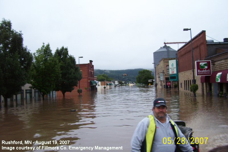
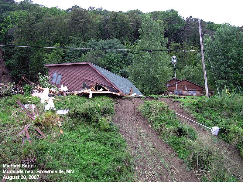
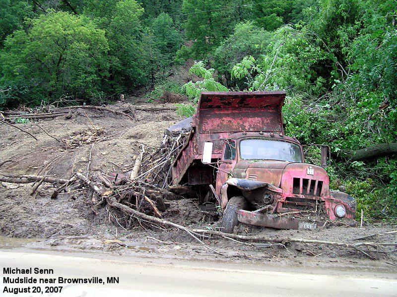
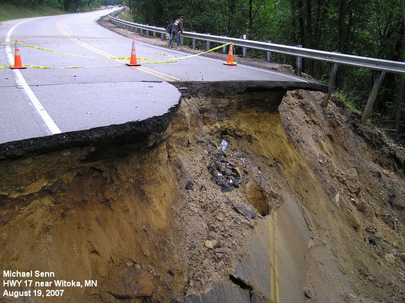
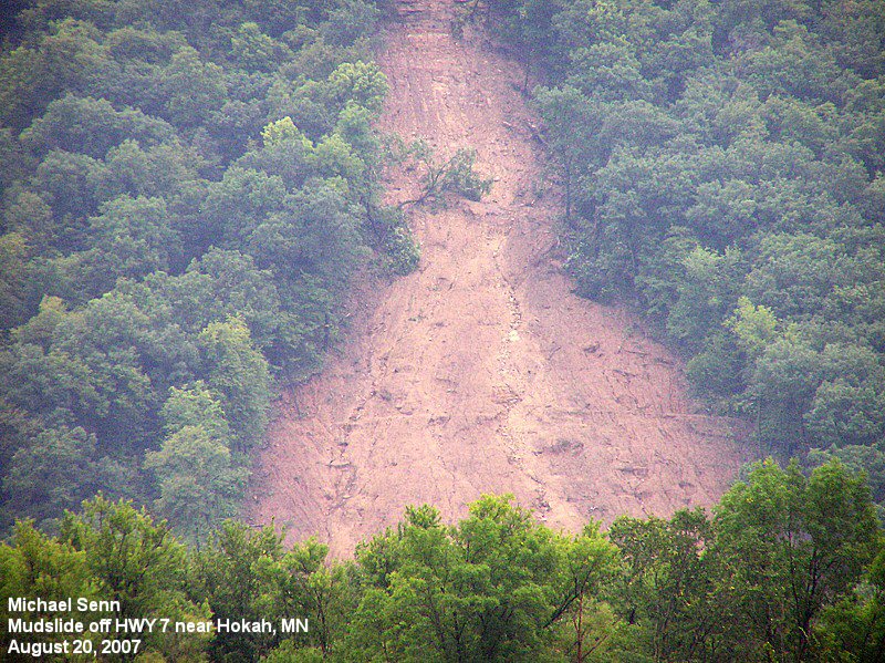
There were numerous mudslides, roads washed out, and flash flooding that killed 7 people. The community of Rushford, MN was flooded by Rush Creek and infrastructure remained damaged for months. Damage costs likely exceeded $200 Million.
|
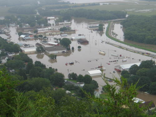 Rushford, MN during the flooding (Photo by Jeff Thompson) |
||||||||||||||||||||||||||||||||||||
Why did it happen?
A stalled frontal boundary acted as the focus for the continuous redevelopment of showers and thunderstorms throughout the weekend. A moist and warm air mass rose up and over this boundary, providing the fuel for the rain. Due to the training nature of the storms, heavy rain persisted hour after hour across southeast Minnesota into southwest Wisconsin, with rainfall rates of 1 to 2 inches per hour common.
Flooding
Zumbro River at Zumbro Falls, MN
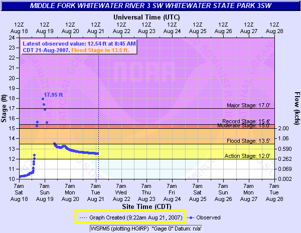
Middle Fork Whitewater River at Whitewater State Park, MN
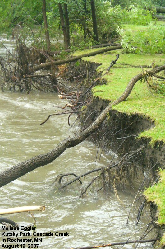
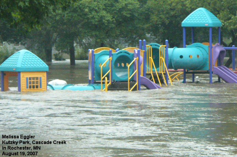
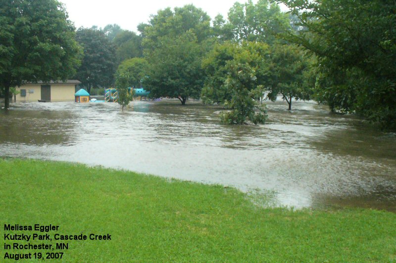
Cascade Creek at Rochester, MN
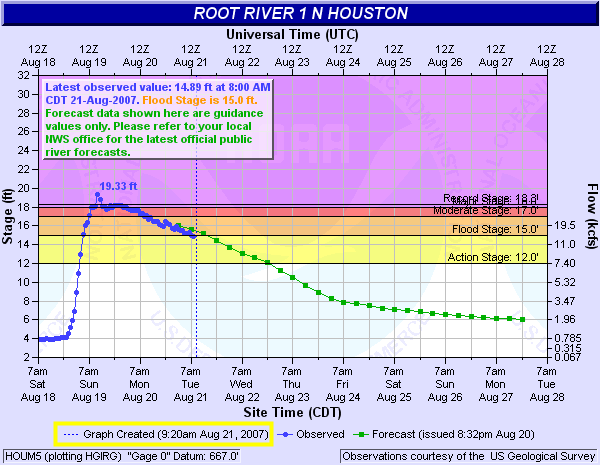
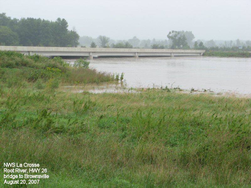
Root River at Houston, MN
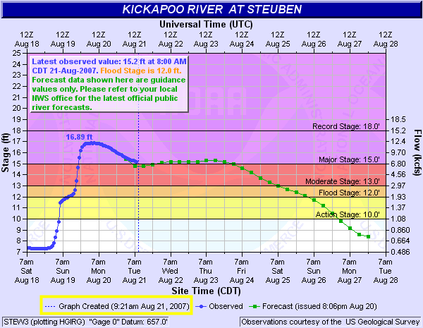
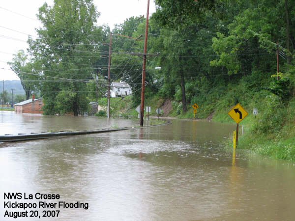
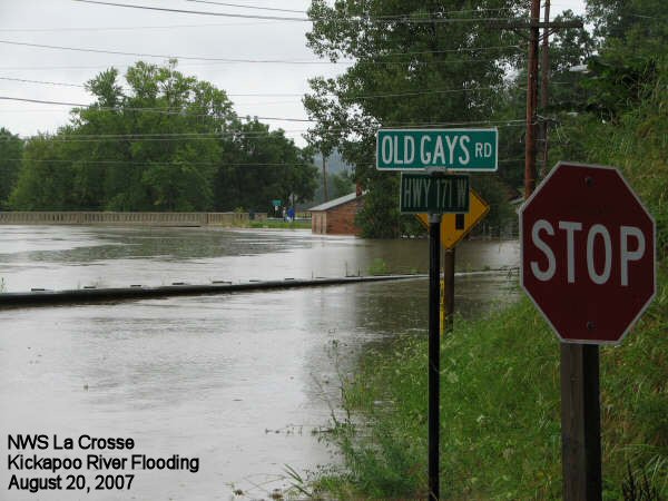
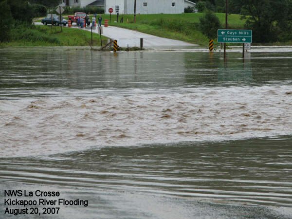
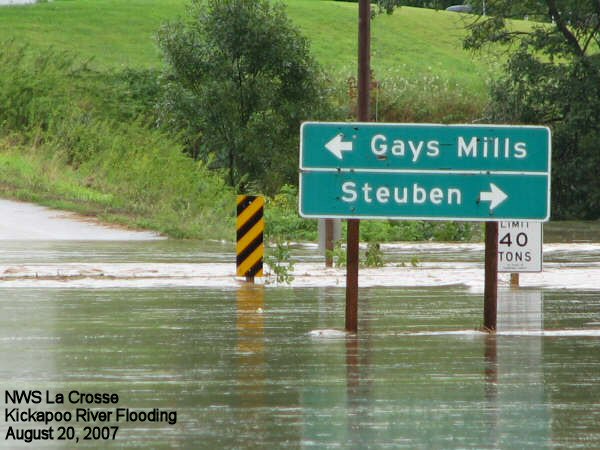
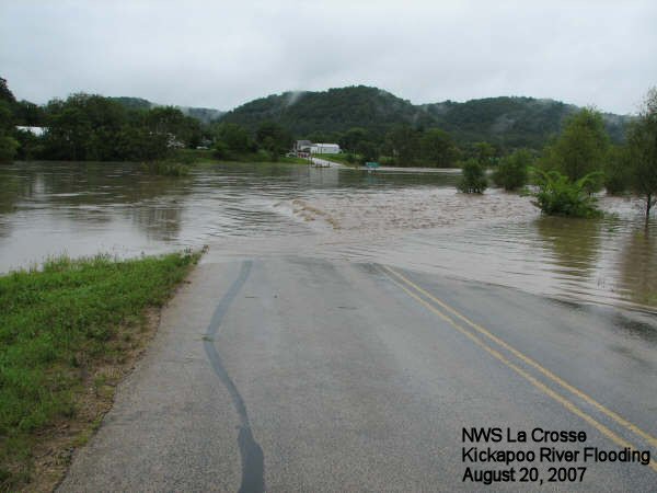
Kickapoo River
Grant River at Burton, WI
South Branch Baraboo River at Hillsboro, WI
Hydrographs
 |
 |
 |
|
| Middle Fork Whitewater River at Whitewater State Park, MN | Root River at Houston, MN | Kickapoo River at Steuben, WI |
Precipitation Totals and Radar Estimates
Some rainfall totals from August 2007:
|
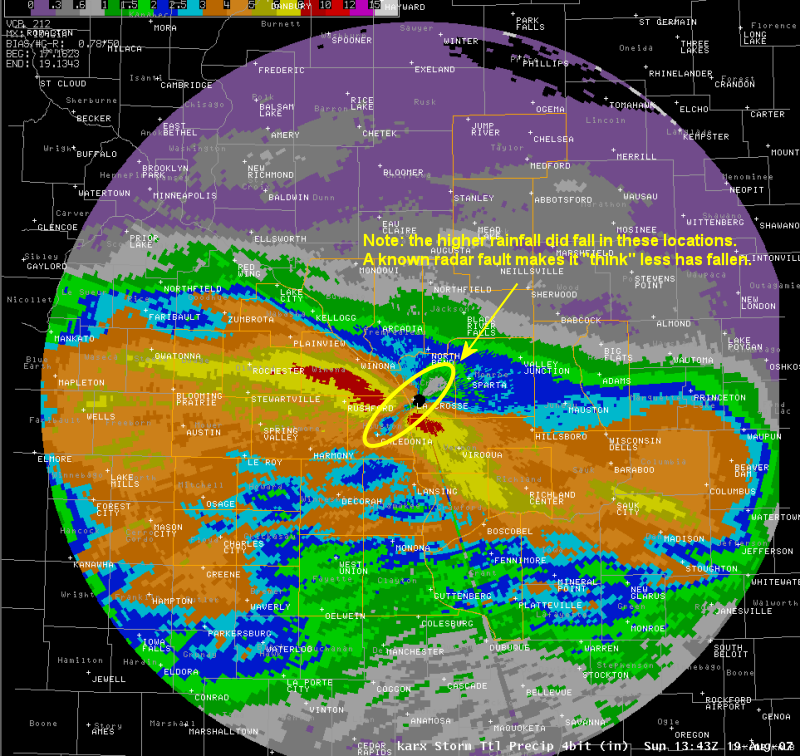 Radar estimated precipitation for Saturday into early Sunday morning. |
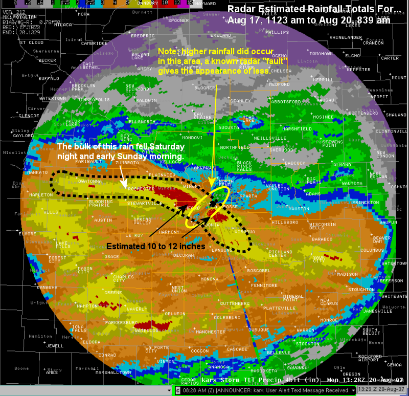 Radar estimated precipitation for Saturday into early Monday morning. |
Services
Heavy rain was expected that night, which prompted a Flash Flood Watch for the area. Graphics and web page stories highlighted the heavy rain potential, although the exact area where the heaviest rain would fall was not detailed initially.
River and flash flood warnings followed and were issued for nearly 2 days given the scope of the heavy rain, massive flooding, and infrastructure damage. Travel was highly discouraged, if not downright dangerous.
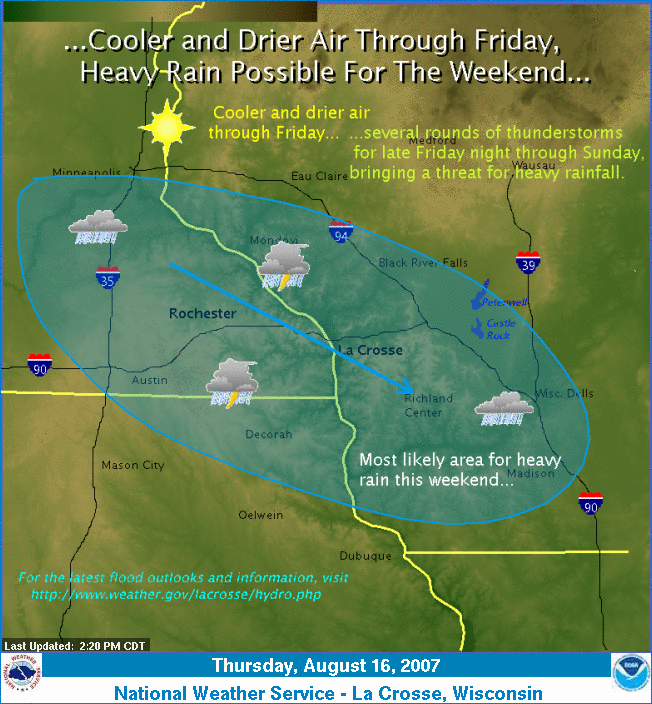
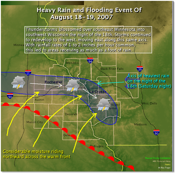
Information released by the NWS:
 |
 |
||
| Weather story graphic leading up to flooding of Aug.18-19, 2007 | Graphic with summary of the event |
Photos:
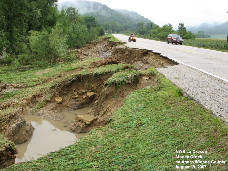
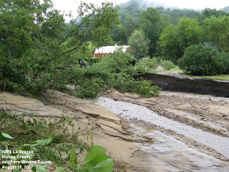
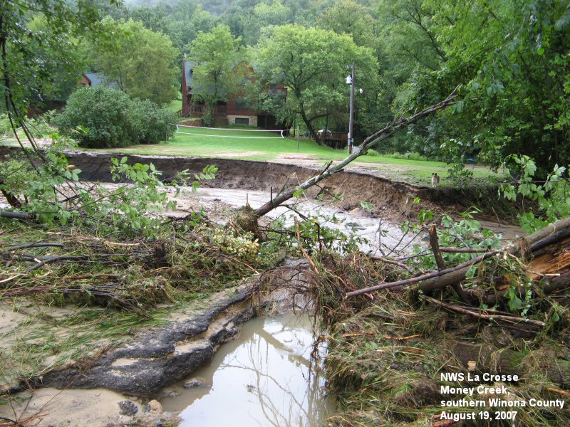
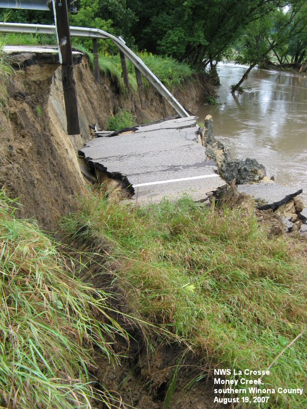
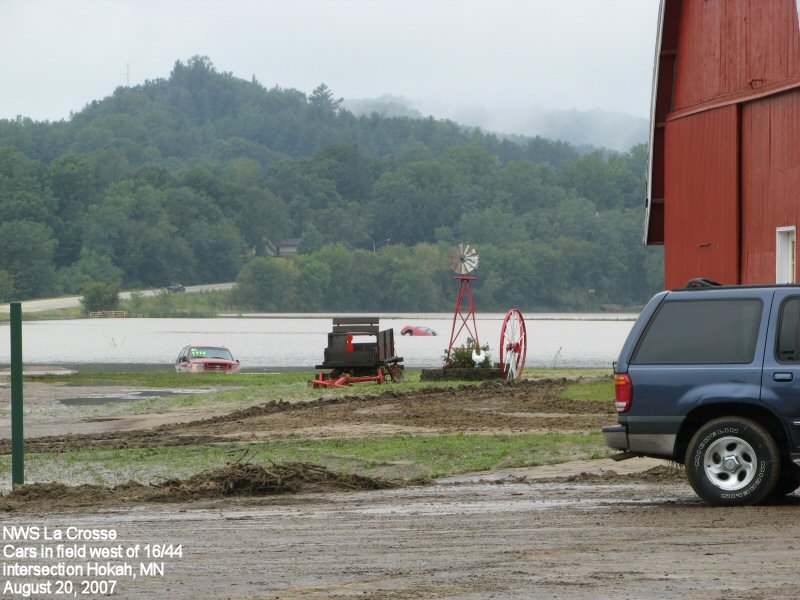
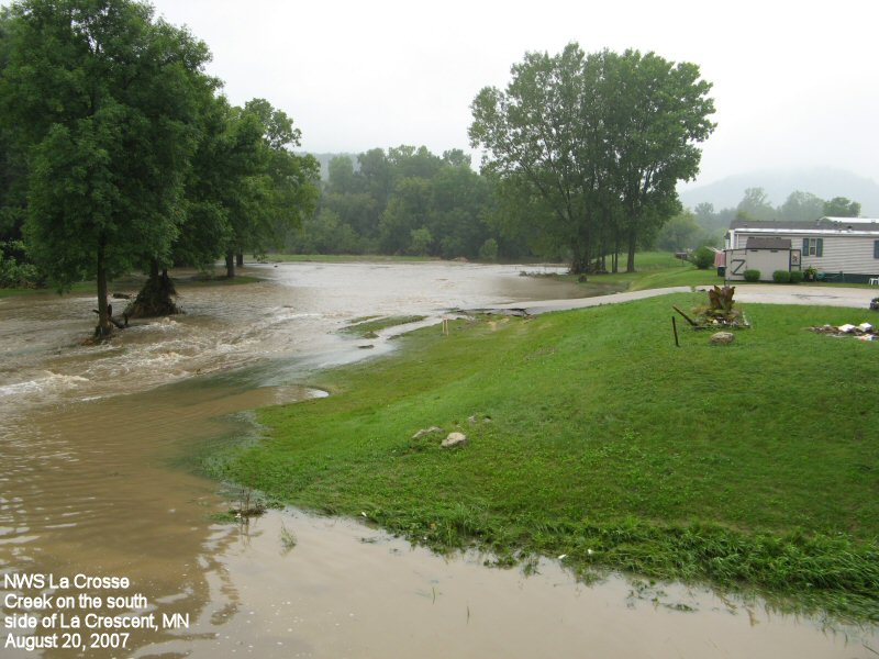
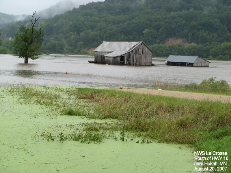
Southeast Minnesota
 |
 |
 |
 |
 |
 |
 |
 |
 |
 |
 |
 |
 |
 |
 |
 |
 |
 |
 |
 |
 |
 |
 |
 |
 |
 |
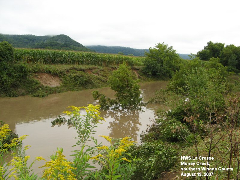
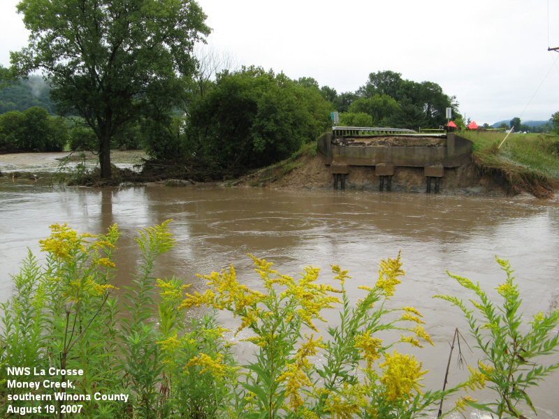
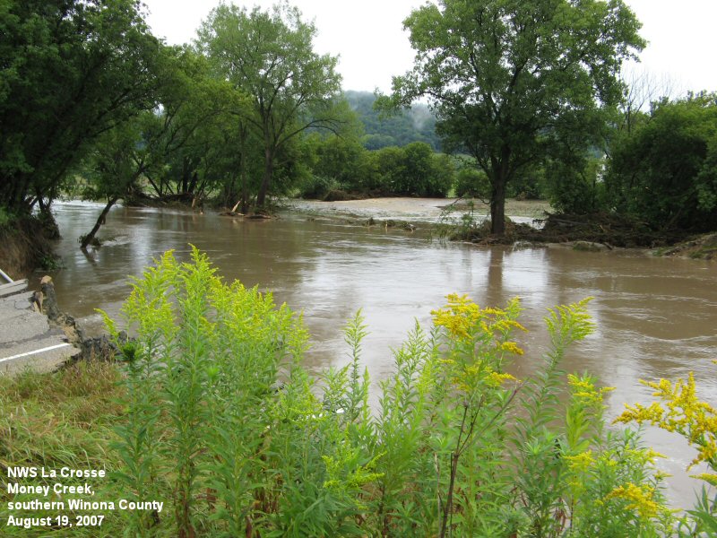
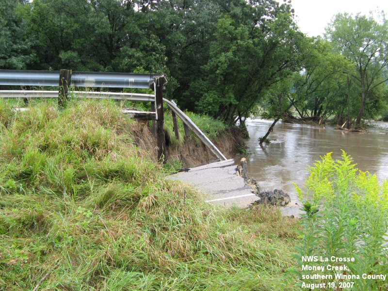
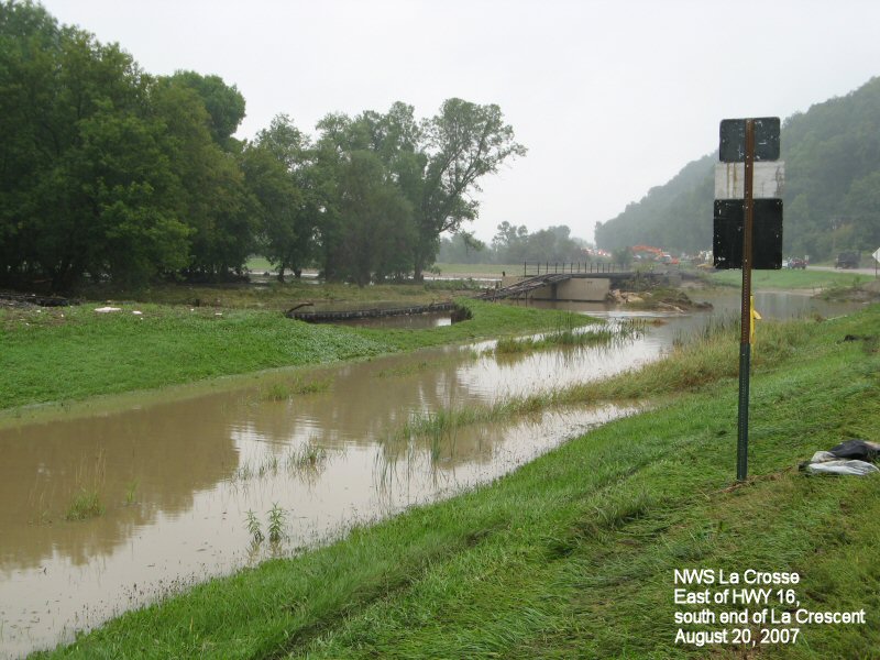
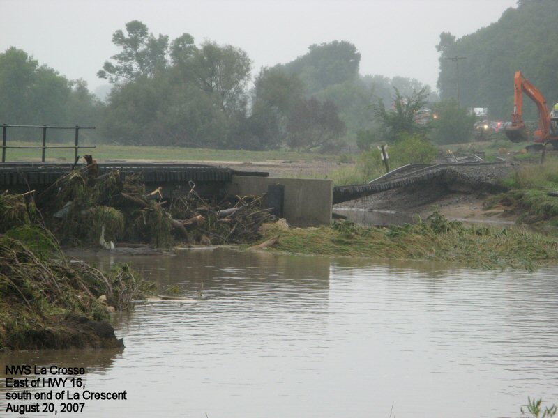
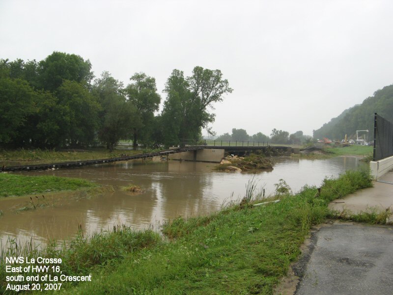
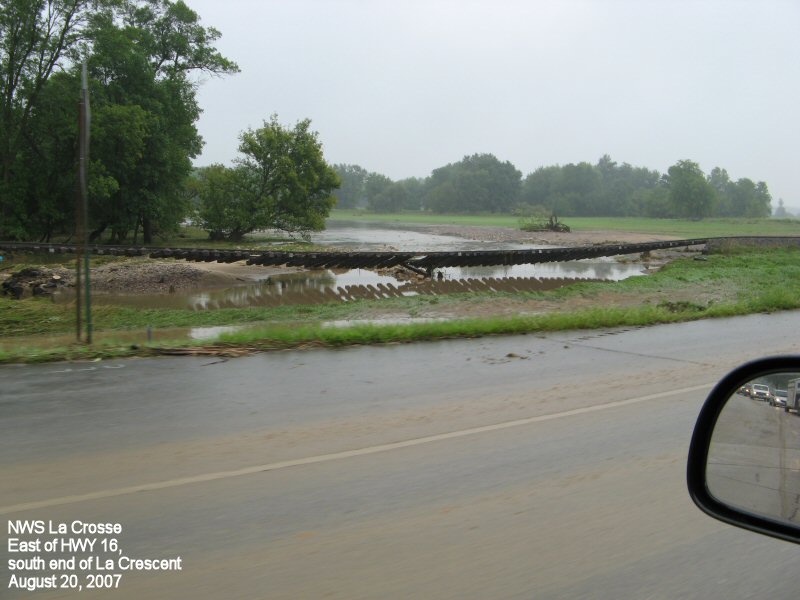
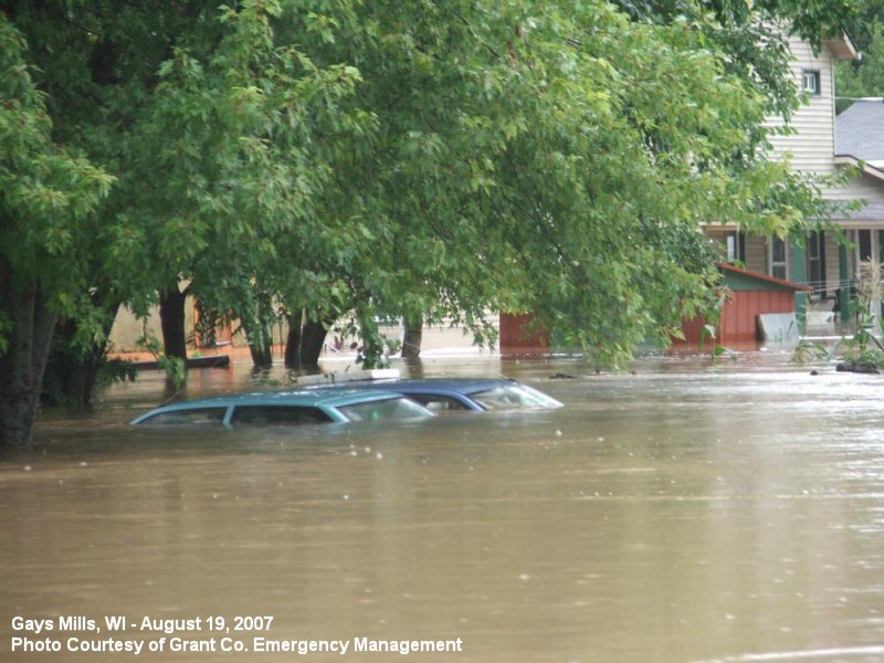
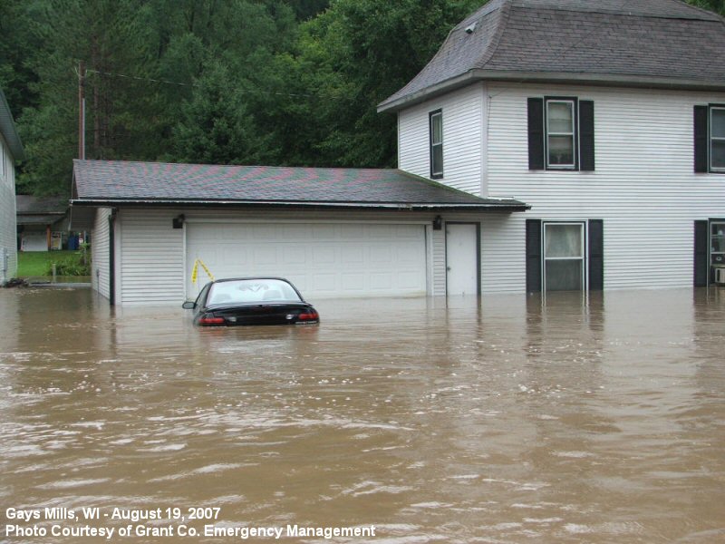
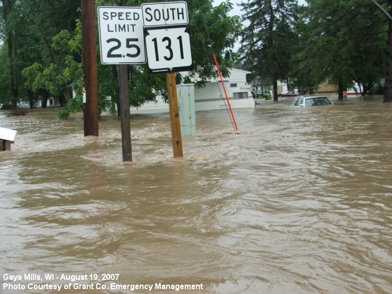
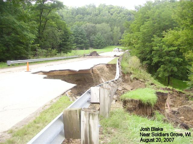
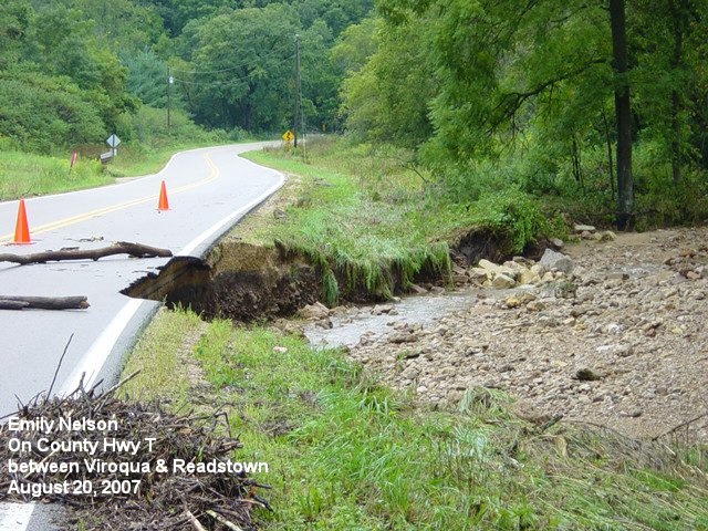
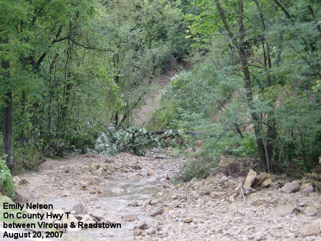
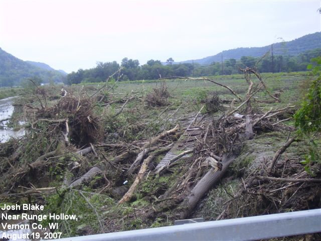
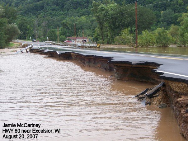
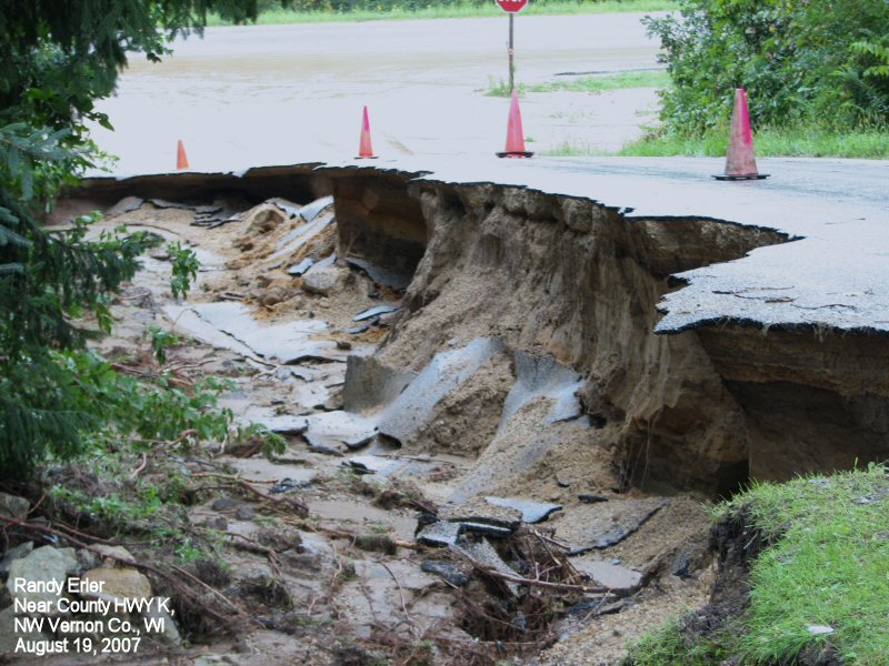
Southwest Wisconsin
 |
 |
 |
 |
 |
 |
 |
 |
 |
 |
 |
 |
 |
 |
 |
 |
 |
 |
Storm Reports
PRELIMINARY LOCAL STORM REPORT...SUMMARY
NATIONAL WEATHER SERVICE LA CROSSE WI
854 PM CDT SUN AUG 19 2007
..TIME... ...EVENT... ...CITY LOCATION... ...LAT.LON...
..DATE... ....MAG.... ..COUNTY LOCATION..ST.. ...SOURCE....
..REMARKS..
0600 PM FLASH FLOOD DODGE CENTER 44.03N 92.85W
08/18/2007 DODGE MN COUNTY OFFICIAL
FLOODING LIMITED MOSTLY TO DITCHES. HOMES REPORTED WITH
WATER IN BASEMENTS. RAILROAD BED WASHED OUT. REPORTS
STARTED COMING INTO DISPATCH AROUND 6 PM
0822 PM FLASH FLOOD 4 NNW HOUSTON 43.81N 91.60W
08/18/2007 HOUSTON MN LAW ENFORCEMENT
MUDSLIDE COVERING HIGHWAY 76 BETWEEN MONEY CREEK AND
HOUSTON. OTHER MUDSLIDES REPORTED ON COUNTY HIGHWAYS
9...13 AND 26.
0840 PM FLASH FLOOD LA CROSSE 43.83N 91.23W
08/18/2007 LA CROSSE WI AMATEUR RADIO
MAJOR STREET FLOODING ON SOUTH SIDE OF LA CROSSE NEAR
WALMART. WATER OVER MORMON COULEE ROAD.
0915 PM FLASH FLOOD LA CROSSE 43.83N 91.23W
08/18/2007 LA CROSSE WI LAW ENFORCEMENT
PORTIONS OF A RETAINING WALL WASHED AWAY AT HIGHWAY 14/61
AND 35 ON SOUTH SIDE OF LA CROSSE
0915 PM FLASH FLOOD 3 W VIROQUA 43.56N 90.95W
08/18/2007 VERNON WI LAW ENFORCEMENT
CREEKS OUT OF THEIR BANKS AT SIDIE HOLLOW CAMPGROUND.
0915 PM FLASH FLOOD ROCHESTER 44.01N 92.48W
08/18/2007 OLMSTED MN COUNTY OFFICIAL
HWY 14 CLOSED EAST OF ROCHESTER. MUDSLIDE AT RONALD
MCDONALD HOUR IN ROCHESTER WITH EVACUATIONS AROUND 6 AM.
RED CROSS SHELTERS WERE SET UP. FLOODING REPORTS BEGAN
AROUND 915 PM SAT AUG 18.
0920 PM FLASH FLOOD LA CROSSE 43.83N 91.23W
08/18/2007 LA CROSSE WI AMATEUR RADIO
MULIPLE HOMES WITH BASEMENT FLOODING. ONE WITH FIRST
FLOOR FLOODING.
0930 PM FLASH FLOOD STODDARD 43.66N 91.22W
08/18/2007 VERNON WI COUNTY OFFICIAL
MUDSLIDES ALL ACROSS THE COUNTY...WITH NUMEROUS COUNTY
ROADS CLOSED AND IMPASSABLE. AREAS SIGNIFICANTLY IMPACTED
ARE FROM AROUND STODDARD TO VIROQUA. AT LEAST 79 PEOPLE
EVACUATED BELOW LOCAL DAMS.
0930 PM FLASH FLOOD HOKAH 43.76N 91.35W
08/18/2007 HOUSTON MN COUNTY OFFICIAL
AT LEAST 50 MUDSLIDES. 4 STATE HWYS AND 8 COUNTY ROADS
CLOSED. REPORTS OF HOME COLLASPES AND SLIDES. TRAIN
TRACKS AND BRIDGES WASHED OUT. NUMEROUS REPORTS OF
INJURIES. 2 UNCONFIRMED FATALITIES. HARDEST HIT
COMMUNITIES INCLUDE HOUSTON...HOKAH...LA CRESCENT...AND
BROWNSVILLE. FIRST CALL OF FLOODING PROBLEMS AROUND 930
PM SAT AUG 18 TO DISPATCH. IT GOT EXCEEDING WORSE AFTER
THAT.
0940 PM FLASH FLOOD 3 S OAK RIDGE 43.25N 91.02W
08/18/2007 CRAWFORD WI LAW ENFORCEMENT
MUD SLIDE ON COUNTY ROAD O SOUTH OF OAK RIDGE.
1000 PM FLASH FLOOD 2 W LA CRESCENT 43.83N 91.34W
08/18/2007 HOUSTON MN LAW ENFORCEMENT
*** 1 FATAL *** DEATH IN VEHICLE ON COUNTY ROAD 6 NEAR
PINE CREEK. TIME ESTIMATED.
1048 PM FLASH FLOOD ELBA 44.09N 92.02W
08/18/2007 WINONA MN EMERGENCY MNGR
THE INTERSECTION OF COUNTY 74 AND STATE HIGHWAY 74 WAS
FLOODED.
1048 PM FLASH FLOOD STOCKTON 44.03N 91.77W
08/18/2007 WINONA MN EMERGENCY MNGR
HIGHWAY 14 AT FARMERS PARK CLOSED BY FLOODING.
1048 PM FLASH FLOOD 2 S LEWISTON 43.96N 91.87W
08/18/2007 WINONA MN EMERGENCY MNGR
CAR STUCK IN HIGH WATER ON COUNTY 29.
1048 PM FLASH FLOOD 4 S RIDGEWAY 43.86N 91.57W
08/18/2007 WINONA MN EMERGENCY MNGR
MUDSLIDE ACROSS COUNTY 11.
1048 PM FLASH FLOOD 3 N RUSHFORD 43.86N 91.75W
08/18/2007 WINONA MN AMATEUR RADIO
STATE HIGHWAY 43 CLOSED SOUTH OF INTERSTATE 90 BY A
MUDSLIDE.
1100 PM FLASH FLOOD LEWISTON 43.98N 91.87W
08/18/2007 WINONA MN BROADCAST MEDIA
TREE AND MUD SLIDES IN LEWISTON.
1112 PM FLASH FLOOD EYOTA 43.99N 92.23W
08/18/2007 OLMSTED MN EMERGENCY MNGR
STREET FLOODING. SAND BAGGING HAS STARTED WITH SOME
STREET CLOSURES.
1116 PM FLASH FLOOD 1 E VIOLA 43.51N 90.65W
08/18/2007 RICHLAND WI EMERGENCY MNGR
WATER OVER HIGHWAY 56.
1116 PM FLASH FLOOD 1 S YUBA 43.52N 90.43W
08/18/2007 RICHLAND WI EMERGENCY MNGR
WATER OVER COUNTY HIGHWAY C.
1116 PM FLASH FLOOD 1 S LOYD 43.40N 90.25W
08/18/2007 RICHLAND WI EMERGENCY MNGR
WATER OVER HIGHWAY 58.
1135 PM FLASH FLOOD WINONA 44.05N 91.66W
08/18/2007 WINONA MN EMERGENCY MNGR
STATE HIGHWAY 43 WASHED OUT JUST SOUTH OF WINONA.
1141 PM FLASH FLOOD RICHLAND CENTER 43.34N 90.38W
08/18/2007 RICHLAND WI COUNTY OFFICIAL
NUMEROUS STATE HIGHWAYS AND COUNTY ROADS CLOSED AND
IMPASSABLE. ESTIMATED 75 PERCENT OF THE COUNTY ROADS ARE
AFFECTED BY FLOOD WATERS. HWY 80 IMPASSABLE WITH BRIDGES
BUCKLED. AT LEAST A DOZEN BOAT RESCUES FROM HOMES AND
CARS. THE TOWN OF ROCKBRIDGE BASICALLY UNDERWATER. FIRST
REPORTED FLOODING INCIDENT IN THE COUNTY WAS 1141 PM ON
THE 18TH.
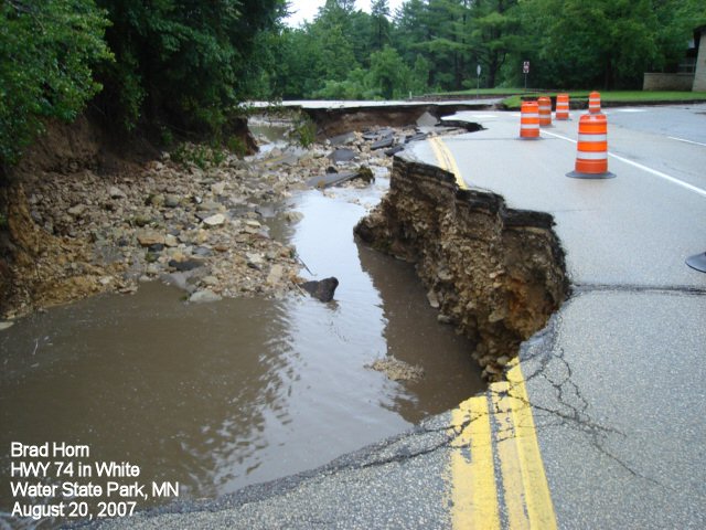
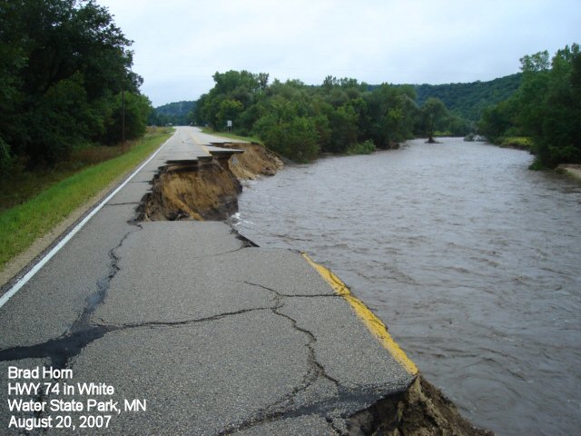
1200 AM FLASH FLOOD 5 W ALTURA 44.07N 92.04W
08/19/2007 WINONA MN PARK/FOREST SRVC
HIGHWAY 74 IN WHITE WATER STATE PARK IS COMPLETELY WASHED
OUT
1205 AM FLASH FLOOD LA CRESCENT 43.83N 91.30W
08/19/2007 HOUSTON MN EMERGENCY MNGR
HIGHWAY 26 FROM LA CRESCENT TO THE IOWA BORDER IS CLOSED.
HIGHWAY 16 FROM JUST SOUTH OF LA CRESCENT TO HOKAH IS
CLOSED. HIGHWAY 61 FROM NORTH OF LA CRESCENT INTO WINONA
COUNTY IS CLOSED.
1215 AM FLASH FLOOD 7 ENE ZUMBRO FALLS 44.33N 92.30W
08/19/2007 WABASHA MN EMERGENCY MNGR
6 INCHES OF WATER OVER COUNTY 2 NORTH OF STATE HIGHWAY
60.
1215 AM FLASH FLOOD ZUMBRO FALLS 44.29N 92.43W
08/19/2007 WABASHA MN EMERGENCY MNGR
STREETS CLOSED IN DOWNTOWN BY HIGH WATER.
1215 AM FLASH FLOOD 1 E MILLVILLE 44.25N 92.28W
08/19/2007 WABASHA MN EMERGENCY MNGR
MUDSLIDE ON COUNTY 11.
1241 AM FLASH FLOOD EYOTA 43.99N 92.23W
08/19/2007 OLMSTED MN EMERGENCY MNGR
HIGHWAY 14 CLOSED AT HIGHWAY 42 FROM FLOODING.
0100 AM FLASH FLOOD EYOTA 43.99N 92.23W
08/19/2007 OLMSTED MN EMERGENCY MNGR
RESIDENTS OF THE EYOTA TRAILER PARK ARE BEING EVACUATED.
0110 AM FLASH FLOOD 2 S DE SOTO 43.40N 91.20W
08/19/2007 CRAWFORD WI LAW ENFORCEMENT
LARGE BOULDER ON HIGHWAY 35 SOUTH OF TOWN.
0110 AM FLASH FLOOD BELL CENTER 43.29N 90.83W
08/19/2007 CRAWFORD WI LAW ENFORCEMENT
SAND CREEK ROAD IS CLOSED FOR THE NIGHT.
0125 AM FLASH FLOOD STODDARD 43.66N 91.22W
08/19/2007 VERNON WI EMERGENCY MNGR
MUDSLIDE JUST SOUTH OF TOWN ON HIGHWAY 35 COLLAPSING A
HOUSE.
0130 AM FLASH FLOOD KASSON 44.03N 92.75W
08/19/2007 DODGE MN EMERGENCY MNGR
FLOODING REPORTED IN TOWN.
0130 AM FLASH FLOOD DODGE CENTER 44.03N 92.85W
08/19/2007 DODGE MN EMERGENCY MNGR
FLOODING REPORTED IN TOWN WITH SOME EVACUATIONS TAKING
PLACE.
0200 AM FLASH FLOOD 2 E HOUSTON 43.76N 91.53W
08/19/2007 HOUSTON MN LAW ENFORCEMENT
*** 1 FATAL *** MOBILE HOME SWEPT AWAY BY FLASH FLOODING.
TIME WAS ESTIMATED.
0220 AM FLASH FLOOD YUBA 43.54N 90.43W
08/19/2007 RICHLAND WI BROADCAST MEDIA
FIRE DEPARTMENT UNDER WATER.
0220 AM FLASH FLOOD CAZENOVIA 43.53N 90.20W
08/19/2007 RICHLAND WI BROADCAST MEDIA
HIGHWAY 58 CLOSED.
0220 AM FLASH FLOOD 3 E YUBA 43.54N 90.37W
08/19/2007 RICHLAND WI AMATEUR RADIO
HIGHWAY 80 HAS BUCKLED NORTH OF CENTURY FARM ROAD.
0245 AM FLASH FLOOD 1 NE COON VALLEY 43.71N 91.00W
08/19/2007 VERNON WI EMERGENCY MNGR
CAR WASHED AWAY AT COUNTY P AND SPRING COULEE
ROAD...PEOPLE ESCAPED.
0245 AM FLASH FLOOD 2 W VIROQUA 43.56N 90.93W
08/19/2007 VERNON WI EMERGENCY MNGR
CAR WASHED AWAY ON HIGHWAY 56...PEOPLE ESCAPED.
0245 AM FLASH FLOOD 4 S GENOA 43.52N 91.23W
08/19/2007 VERNON WI EMERGENCY MNGR
MUDSLIDE WITH POWER LINES DOWN AT SHADY LANE AND HIGHWAY
35.
0300 AM FLASH FLOOD WINONA 44.05N 91.66W
08/19/2007 WINONA MN LAW ENFORCEMENT
*** 4 FATAL *** CORRECTED THE NUMBER OF REPORTED
FATALITIES IN WITOKA FROM 3 TO ONLY 2...WITH STILL 2
FATALITIES IN STOCKTON. THE TIMES ARE STILL UNKNOWN AND
EMERGENCY MANAGEMENT OFFICIALS IN WINONA COUNTY REPORT 3
TO 4 PEOPLE ARE STILL MISSING. NUMEROUS INJURIES WERE
REPORTED COUNTY WIDE BUT LOCAL HOSPITALS ARE NOT
RELEASING ACCURATE NUMBERS. ALSO HWY 61 FROM WINONA TO
GOODVIEW IS CLOSED.
0305 AM FLASH FLOOD SOLDIERS GROVE 43.39N 90.77W
08/19/2007 CRAWFORD WI LAW ENFORCEMENT
2 FEET OF WATER OVER HIGHWAY 61 SOUTH OF TOWN AND THE
ROAD IS CLOSED IN SOLDIERS GROVE.
0325 AM FLASH FLOOD 2 WSW ELGIN 44.12N 92.29W
08/19/2007 WABASHA MN LAW ENFORCEMENT
COUNTY 2 CLOSED NEAR THE OLMSTED COUNTY LINE.
0325 AM FLASH FLOOD ZUMBRO FALLS 44.29N 92.43W
08/19/2007 WABASHA MN AMATEUR RADIO
WATER OVER THE ROAD AT HIGHWAYS 60 AND 63.
0349 AM FLASH FLOOD 3 WNW ELGIN 44.15N 92.31W
08/19/2007 WABASHA MN LAW ENFORCEMENT
COUNTY 25 CLOSED NEAR THE OLMSTED COUNTY LINE.
0349 AM FLASH FLOOD GOOSE ISLAND 43.74N 91.22W
08/19/2007 LA CROSSE WI LAW ENFORCEMENT
CAMP GROUND EVACUATED DUE TO FLASH FLOODING
0430 AM FLASH FLOOD SOLDIERS GROVE 43.39N 90.77W
08/19/2007 CRAWFORD WI COUNTY OFFICIAL
NUMEROUS ROADS AND STATE HIGHWAYS CLOSED...MOSTLY IN THE
NORTHEAST SECTION OF THE COUNTY. NURSING HOME EVACUATED
IN SOLDIERS GROVE. NUMEROUS RESIDENTS EVACUATED IN GAYS
MILLS AND SOLDIERS GROVE. FIRST REPORT OF FLOODING
INDICENT FROM DISPATCH WAS ROUGHLY 430 AM.
1200 PM HEAVY RAIN 2 SW LA CRESCENT 43.81N 91.33W
08/19/2007 M15.60 INCH HOUSTON MN TRAINED SPOTTER
SPOTTER REPORTED 15.60 INCHES OF RAIN. 12.73 INCHES OF
THIS RAIN FELL BETWEEN 8 PM AUGUST 18TH AND 3 AM AUGUST
19TH.
0530 PM FLASH FLOOD CHARLES CITY 43.07N 92.68W
08/19/2007 FLOYD IA LAW ENFORCEMENT
WATER REPORTED IN BASEMENTS AND MINOR FLOODING REPORTED
ALONG HIGHWAY 18 IN THE CHARLES CITY AREA
0726 PM FLASH FLOOD JERICO 43.18N 92.26W
08/19/2007 CHICKASAW IA LAW ENFORCEMENT
CRANE CREEK IS OUT OF ITS BANKS AND FLOODING COUNTY ROAD
B22
0808 PM FLASH FLOOD PROTIVIN 43.22N 92.09W
08/19/2007 HOWARD IA LAW ENFORCEMENT
BOHEMIAN CREEK HAS WENT OUT OF ITS BANKS AND SAND BAGGING
IS CURRENTLY TAKING PLACE IN PROTIVIN
0808 PM FLASH FLOOD ELMA 43.25N 92.44W
08/19/2007 HOWARD IA LAW ENFORCEMENT
MINOR FLOODING WAS REPORTED
0845 PM FLASH FLOOD LA CROSSE 43.83N 91.23W
08/19/2007 LA CROSSE WI LAW ENFORCEMENT
THE 1900 BLOCK OF ST JAMES STREET IS FLOODING
0845 PM FLASH FLOOD LA CROSSE 43.83N 91.23W
08/19/2007 LA CROSSE WI LAW ENFORCEMENT
MORMON COULEE IS FLOODING NEAR KWIK TRIP AND WALMART
0845 PM FLASH FLOOD ONALASKA 43.89N 91.22W
08/19/2007 LA CROSSE WI LAW ENFORCEMENT
BERM IS WASHING AWAY NEAR THE INTERSECTION OF HIGHWAY 53
AND SAND LAKE ROAD
Rain Reports Ending 7AM Sunday Aug.19th
PUBLIC INFORMATION STATEMENT
NATIONAL WEATHER SERVICE LA CROSSE WI
1135 AM CDT SUN AUG 19 2007

... 24 HOUR RAINFALL TOTALS ACROSS THE AREA...

LOCATION                   COUNTY              RAINFALL

...IOWA...
CALMAR                     WINNESHIEK           4.24
ST ANSGAR                  MITCHELL             3.55
POSTVILLE                  ALLAMAKEE            3.53
DECORAH 8ENE               WINNESHIEK           3.50
LANSING 4SE                ALLAMAKEE            3.17
WAUKON                     ALLAMAKEE            2.90
CHARLES CITY COOP          FLOYD                2.76
ELMA                       HOWARD               2.46
CRESCO                     HOWARD               2.44
CHARLES CITY AWOS          FLOYD                2.19
MARQUETTE                  CLAYTON              2.10
ION                        ALLAMAKEE            2.06
COLWELL                    FLOYD                1.85
ELKADER 6SSW               CLAYTON              1.33
MCGREGOR                   CLAYTON              1.31
LITTLEPORT                 CLAYTON              1.25
OELWEIN 1E                 FAYETTE              1.07
EDGEWOOD                   CLAYTON              1.00
ELKADER                    CLAYTON              0.93
GUTTENBERG DAM 10          CLAYTON              0.75
GARBER                     CLAYTON              0.63
FAYETTE                    FAYETTE              0.63

...MINNESOTA...
WHITEWATER STATE PARK 3SW  WINONA               11.50
LA CRESCENT 1NNW           HOUSTON              10.75
ROCHESTER - CASCADE CREEK  OLMSTED              10.45
ROCHESTER - SILVER CREEK   OLMSTED              10.17
ROCHESTER - BEAR CREEK     OLMSTED              9.86
DODGE CENTER               DODGE                8.50
LA CRESCENT DAM 7          WINONA               7.95
MANTORVILLE                DODGE                7.85
ZUMBRO FALLS               WABASHA              7.79
BROWNSVILLE                HOUSTON              6.82
ROCHESTER AP 2NE           OLMSTED              6.63
ROCHESTER MAPLE VALLEY     OLMSTED              6.16
ROCHESTER INTL AP          OLMSTED              6.13
THEILMAN 1SSW              WABASHA              5.95
DAKOTA 5NW                 WINONA               5.95
SPRING GROVE 4N            HOUSTON              5.65
CHATFIELD                  FILLMORE             5.35
WINONA DAM 5A              WINONA               5.10
ROCHESTER BELTLINE         OLMSTED              4.95
GRAND MEADOW               MOWER                4.89
CALEDONIA 6S               HOUSTON              4.83
DODGE CENTER AWOS          DODGE                4.67
PRESTON                    FILLMORE             4.61
SPRING VALLEY 3SW          FILLMORE             4.50
MINNESOTA CITY DAM 5       WINONA               4.25
AUSTIN                     MOWER ***            3.97
LANSING                    MOWER                3.74
AUSTIN                     MOWER                3.54
HARMONY                    FILLMORE             3.48
WHITEWATER STATE PARK 3SW  OLMSTED              3.05
PRESTON AWOS               FILLMORE             2.87
WABASHA                    WABASHA              2.56
LAKE CITY-COOP             WABASHA              2.43
LAKE CITY                  WABASHA              2.13
AUSTIN AWOS                MOWER                1.61

...WISCONSIN...
STODDARD 3NE               VERNON               11.75
LA CROSSE 1ESE             LA CROSSE            10.95
LA CROSSE MISSISSIPPI RIVERLA CROSSE            10.09
LA CROSSE 5SE              LA CROSSE            9.42
READSTOWN                  VERNON               9.30
VIROQUA                    VERNON               9.23
VIOLA                      VERNON               7.86
LA CROSSE WFO              LA CROSSE            7.59
GAYS MILLS                 CRAWFORD             7.41
WESTBY 3ENE                VERNON               7.17
GENOA DAM 8                VERNON               7.10
VALLEY 1NW                 VERNON               6.40
LA FARGE                   VERNON               6.14
LA CROSSE ASOS             LA CROSSE            5.97
ONTARIO                    VERNON               5.80
MUSCODA 6S                 GRANT                5.50
ONTARIO                    VERNON ***           5.40
HILLSBORO                  VERNON               4.50
STEUBEN                    CRAWFORD             4.42
BOSCOBEL RAWS              GRANT                3.89
BOSCOBEL ASOS              GRANT                3.83
WEST SALEM 1NW             LA CROSSE            3.71
HOLMEN                     LA CROSSE            3.59
STEUBEN 4SE                CRAWFORD             3.55
TREMPEALEAU DAM 6          TREMPEALEAU          3.50
WILTON 3E                  MONROE               3.31
GALESVILLE 1S              TREMPEALEAU          3.30
TUNNEL CITY 1S             MONROE               3.18
CATARACT                   MONROE               3.10
FOUR CORNERS               MONROE               3.08
ETTRICK 5SE                TREMPEALEAU          3.05
ROCKVILLE                  GRANT                2.93
VOLK FIELD                 JUNEAU               2.89
WARRENS 5WSW               MONROE               2.75
ALMA DAM 4                 BUFFALO              2.75
LYNXVILLE DAM 9            CRAWFORD             2.60
NECEDAH 5WNW CRN           JUNEAU               2.51
NECEDAH 2SE                JUNEAU               2.47
NECEDAH RAWS               JUNEAU               2.45
BLACK RIVER FALLS STP      JACKSON              2.45
SPARTA - FT MC COY         MONROE               2.37
TAYLOR                     JACKSON              2.10
MONTANA                    BUFFALO              1.96
BURTON                     GRANT                1.76
MONDOVI MIRROR LAKE        BUFFALO              1.75
BLAIR                      TREMPEALEAU          1.75
MATHER 3NW                 JACKSON              1.68
CUBA CITY 2NW              GRANT                1.39
HATFIELD                   JACKSON              1.27
BLACK RIVER FALLS          JACKSON              1.17
NEILLSVILLE                CLARK                0.99
MONDOVI 6S                 BUFFALO              0.94
OWEN 2N                    CLARK                0.58
GALESVILLE                 TREMPEALEAU          0.48
GAD 6E                     TAYLOR               0.41
MEDFORD                    TAYLOR               0.40
DIAMOND LAKE RAWS          TAYLOR               0.36
ELK MOUND                  DUNN                 0.35
GOODRICH 1E                TAYLOR               0.30
MEDFORD AWOS               TAYLOR               0.17

OBSERVATIONS ARE COLLECTED FROM A VARIETY OF SOURCES WITH VARYING
EQUIPMENT AND EXPOSURE. NOT ALL DATA LISTED IS CONSIDERED OFFICIAL.

FOR THIS...AND A WEALTH OF OTHER RIVER AND WEATHER INFORMATION...
VISIT OUR WEBSITE AT  WEATHER.GOV/LACROSSE
Rain Reports Ending 7AM Monday Aug.20th
PUBLIC INFORMATION STATEMENT
NATIONAL WEATHER SERVICE LA CROSSE WI
757 AM CDT MON AUG 20 2007

... 24 HOUR RAINFALL TOTALS ACROSS THE AREA...

LOCATION                   COUNTY              RAINFALL

...IOWA...
NEW HAMPTON                CHICKASAW            4.25
ELKADER                    CLAYTON              3.92
CHARLES CITY AWOS          FLOYD                3.59
ELKADER 6SSW               CLAYTON              3.55
STRAWBERRY POINT           CLAYTON              3.04
GUTTENBERG DAM 10          CLAYTON              2.91
EDGEWOOD                   CLAYTON              2.90
GARBER                     CLAYTON              2.74
LITTLEPORT                 CLAYTON              2.57
MARQUETTE                  CLAYTON              2.51
OELWEIN AWOS               FAYETTE              2.15
ION                        ALLAMAKEE            1.96
COLWELL                    FLOYD                1.70
OSAGE                      MITCHELL             1.65
MCGREGOR                   CLAYTON              1.61
POSTVILLE                  ALLAMAKEE            1.56
IONIA 2W                   CHICKASAW            1.15
WAUKON                     ALLAMAKEE            1.12
DORCHESTER                 ALLAMAKEE            1.03

...MINNESOTA...
LA CRESCENT DAM 7          WINONA               1.13
BROWNSVILLE                HOUSTON              1.08
HARMONY                    FILLMORE             1.03
GRAND MEADOW               MOWER                0.93
LANSING                    MOWER                0.85
AUSTIN                     MOWER                0.80
ROCHESTER MAPLE VALLEY     OLMSTED              0.69
DAKOTA                     WINONA               0.67
MINNESOTA CITY DAM 5       WINONA               0.65
ROCHESTER INTL AP          OLMSTED              0.64
LAKE CITY                  WABASHA              0.59
DODGE CENTER               DODGE                0.55
WINONA DAM 5A              WINONA               0.54
SPRING VALLEY              FILLMORE             0.54
ELGIN 2SSW                 OLMSTED              0.51
ROCHESTER AP 2NE           OLMSTED              0.41
ZUMBRO FALLS               WABASHA              0.35
PRESTON AWOS               FILLMORE             0.35
ROCHESTER - CASCADE CREEK  OLMSTED              0.31
MANTORVILLE                DODGE                0.31
ROCHESTER - SILVER CREEK   OLMSTED              0.24
ROCHESTER - BEAR CREEK     OLMSTED              0.22
DODGE CENTER AWOS          DODGE                0.16
WINONA AWOS                WINONA               T

...WISCONSIN...
ROCKVILLE                  GRANT                4.04
BURTON                     GRANT                3.04
NEILLSVILLE                CLARK                1.53
BOSCOBEL RAWS              GRANT                1.29
STEUBEN                    CRAWFORD             1.28
TREMPEALEAU DAM 6          TREMPEALEAU          1.26
MONDOVI                    BUFFALO              1.26
BOSCOBEL ASOS              GRANT                1.25
MONROE CENTER              ADAMS                1.20
WHITEHALL 2W-HWY DEPT      TREMPEALEAU          1.02
HOLMEN 2NW                 LA CROSSE            1.01
LA CROSSE ASOS             LA CROSSE            0.99
WEST SALEM 1NW             LA CROSSE            0.98
LYNXVILLE DAM 9            CRAWFORD             0.98
WARRENS 5WSW               MONROE               0.95
TUNNEL CITY 1S             MONROE               0.95
DIAMOND LAKE RAWS          TAYLOR               0.95
NECEDAH RAWS               JUNEAU               0.93
HOLMEN 2S                  LA CROSSE            0.79
TAYLOR                     JACKSON              0.76
VOLK FIELD                 JUNEAU               0.71
ALMA DAM 4                 BUFFALO              0.71
PRAIRIE DU CHIEN AP AWOS   CRAWFORD             0.68
LA CROSSE                  LA CROSSE            0.62
ONTARIO                    VERNON               0.60
SPARTA - FT MC COY         MONROE               0.56
GENOA DAM 8                VERNON               0.55
GALESVILLE                 TREMPEALEAU          0.46
MEDFORD AWOS               TAYLOR               0.42

OBSERVATIONS ARE COLLECTED FROM A VARIETY OF SOURCES WITH VARYING
EQUIPMENT AND EXPOSURE. NOT ALL DATA LISTED IS CONSIDERED OFFICIAL.
 |
Media use of NWS Web News Stories is encouraged! Please acknowledge the NWS as the source of any news information accessed from this site. |
|


 Weather Story
 Weather Map
 Local Radar