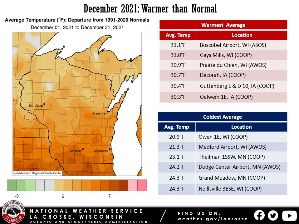
During December 2021, average temperatures in the Upper Mississippi River Valley ranged from 1°F to 5°F warmer-than-normal. The average temperatures ranged from 20.9°F near Owen, WI to 31.1°F at Boscobel, WI. December average temperatures typically range from 15°F to 25°F.
The warmest temperature was 72°F at Boscobel Airport on December 15. Meanwhile, the coldest temperature was -17°F near Owen, WI on December 9.
On December 15, La Crosse Regional Airport had a high temperature of 69°F. This was their warmest temperature ever in December. The previous record was 67°F on December 5, 1998. On this same date, Rochester International Airport had a high temperature of 64°F. This tied December 4, 2017, for their warmest temperature ever in December.
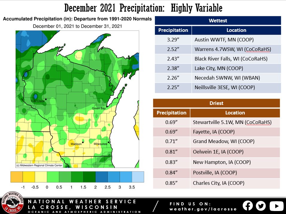
December 2021 precipitation was highly variable across the upper Mississippi River Valley. Precipitation departures were up to 1" drier-than-normal south of Interstate 90 to 1.5" wetter than normal north of this Interstate. Precipitation totals ranged from 0.69" near Stewartville, MN (CoCoRaHS observer) and Fayette, IA (COOP observer) to 3.29" at the Austin Waste Water Treatment Facility (COOP observer). December precipitation typically ranges from 1.2 to 2".
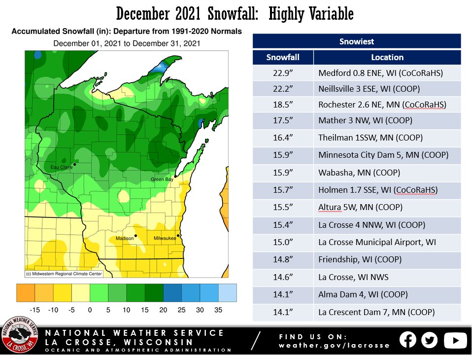
December 2021 snowfall was highly variable across the Upper Mississippi River Valley. It was up to 5" below normal south of Interstate 90 and up to 8" above-normal north of this Interstate. Snow totals ranged from 3.0" at Lynxville Dam 9, IA and Prairie du Chien, WI to 22.9" just east of Medford, WI. Snowfall typically ranges from 7.5 to 15".
 |
 |
 |
| Temperature Anomnalies |
Precipitation Anomalies |
Snowfall Anomalies |
The following are the monthly climate summaries for La Crosse, WI, and Rochester, MN.
La Crosse, WI
December 2021...Warmer and Slightly Wetter than Normal in La Crosse, WI
...December 2021 Highlights...
Temperatures...Warmer-than-Normal
- The average temperature was 28.7°F. This was 3.6°F warmer than the 1991-2020 normal of 25.1°F. This was the 22nd warmest December and the warmest since 2018 (tied with 1994 for the 19th warmest). The warmest December was 38.9°F in 1877.
- The average high temperature was 37.3°F. This was 4.7°F warmer than the 1991-2020 normal of 32.6°F. This was the 14th warmest in December and the warmest since 2015 (39.4°F - 5th warmest). The warmest average high temperature in December was 44°F in 1877.
- The average low temperature was 20.1°F. This was 2.5°F warmer than the 1991-2020 normal of 17.6°F. This was tied with 1979 for the 28th warmest in a December and the warmest since 2018 (23.5°F - tied for 11th warmest with 1913, 1965, and 2006). The warmest average low temperature in December was 33.9°F in 1877.
|
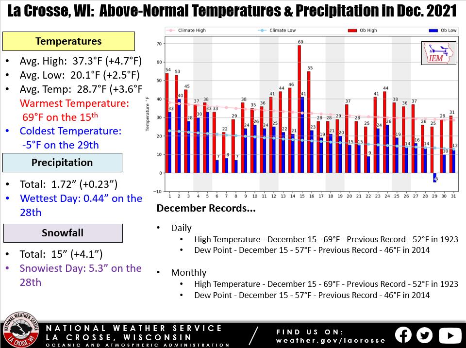 |
- The warmest temperature was 69°F on December 15. This was also the warmest temperature ever in December. The previous record was 67°F on December 5, 1998.
- The coldest temperature was -5°F on December 29. Coldest December temperature since December 31, 2017 (-11°F).
Precipitation...Slightly Wetter-than-Normal
- A total of 1.72" of precipitation fell. Which was 0.23" wetter than the 1991-2020 normal of 1.49".
- The wettest day was December 28 when 0.44" of precipitation fell.
Snowfall...24th Greatest in December
- A total of 15" of snow fell. Which was 4.1" snowier than the 1991-2020 normal of 10.9". This was the most snow in December since 2016 (20.8" - 11th most). The greatest snow amount in December is 32.7" in 2008.
- The snowiest day was December 28 when 5.3" of snow fell. This was the greatest one-day December snowfall since 5.8" fell on December 11, 2016.
Snow Depth...
- The average snow depth was 1.5". Which was 1.4" less than the long-term average (1872-2021) of 2.9".
- The greatest snow depth was 7" on December 30 and December 31.
Historic Storm of December 15-16, 2021...
- On December 15, the Storm Prediction Center issued the first moderate risk of severe weather and Tornado Watch in December for the area. During that evening, a line of severe thunderstorms moved through the region. This prompted 2 Severe Thunderstorm Warnings for La Crosse County. These were the first ones issued during December.
- These thunderstorms were fueled by uncharacteristically warm temperatures and moist dew points. The temperature climbed to 69°F (warmest ever in December) at La Crosse Regional Airport. The dew point climbed 57°F. This tied December 2, 1982, and December 5, 2001, for the second-highest December dew point. The highest dew point was 58°F on December 5, 2001.
- The highest wind gust was 68 mph during the early morning hours of December 16. This was the 2nd highest wind gust at this airport. The highest wind gust was 78 mph on March 30, 1982. The wind gusted also to 63 mph on the evening of December 15. Both of these wind gusts were associated with a strong low pressure system that moved northeast through Minnesota. The sea level pressure fell to 988 mb or 29.18" mercury with this system. This was the 6th lowest December sea level pressure. The lowest December sea level pressure was 976.3 mb (28.83" mercury). It was the lowest December sea level pressure since December 23, 2020 (987.2 mb or 29.15" of mercury - 5th lowest in December).
...Records...
Daily...
- High Temperature - December 15 - 69°F - Previous Record - 52°F in 1923
- Dew Point - December 15 - 57°F - Previous Record - 46°F in 2014
Monthly...
- High Temperature - December 15 - 69°F - Previous Record - 67°F on December 5, 1998
- Highest Dew Point so Late in the Year - 57°F - Previous Record - 47°F on December 29, 2019
...Looking ahead to January...
- The normal high temperatures in La Crosse range from 27 to 28°F. The coldest normal high temperatures occur from January 8 through January 27. The normal low temperatures range from 10 to 13°F. The coldest low temperatures occur from January 13 through the end of the month. The warmest January temperature on record is 57°F on January 3, 1874, January 1, 1897, and January 25, 1981, and the coldest temperature is -43°F on January 18, 1873.
- The normal mean temperature for the month is 18.9°F. La Crosse’s warmest January occurred in 1880 with an average temperature of 32°F, and their coldest January occurred in 1912 with an average temperature of -1.1°F (coldest month ever recorded).
- The normal January precipitation is 1.25". The wettest January occurred in 1886 with 3.44" of precipitation and the driest January occurred in 1948 and 1981 with just 0.14". The wettest January day occurred on January 5, 1946, when 1.67" of precipitation fell.
- The normal January snowfall is 11.8" (snowiest month by average). The snowiest January occurred in 1929 with 39.6" of snow (snowiest month ever recorded) and the least snow was 1.6" in 1903 and 2006. The snowiest January day occurred on January 26, 1996, when 12" of snow fell.
Rochester, MN
December 2021...Warmer and Slightly Wetter than Normal in Rochester, MN
...December 2021 Highlights...
Temperatures...Tied for 14th Warmest
- The average temperature was 24.9°F. This was 4.1°F warmer than the 1991-2020 normal of 20.8°F. This was tied for the 14th warmest December with 1911 and 1957 and the warmest since 2015 (29.8°F - 2nd warmest). The warmest December was 30.7°F in 1931.
- The average high temperature was 33°F. This was 5°F warmer than the 1991-2020 normal of 28°F. This was the 13th warmest in December and the warmest since 2015 (34.9°F - 6th warmest). The warmest average high temperature in December was 44°F in 1877.
- The average low temperature was 16.8°F. This was 3.2°F warmer than the 1991-2020 normal of 13.6°F. This was the 20th warmest in December and the warmest since 2018 (17.9°F - 13th warmest). The warmest average low temperature in December was 24.8°F in 2015.
|
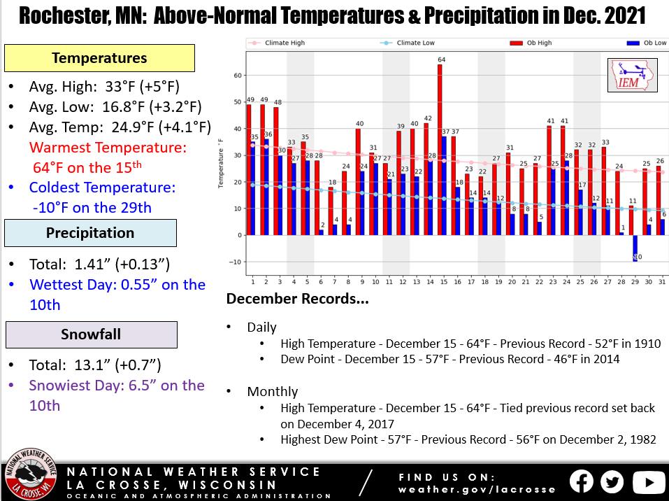 |
- The warmest temperature was 64°F on December 15. This tied December 4, 2017, for the warmest temperature ever in December.
- The coldest temperature was -10°F on December 29. Coldest December temperature since December 31, 2017 (-17°F).
Precipitation...Slightly Wetter-than-Normal
- A total of 1.41" of precipitation fell. Which was 0.13" wetter than the 1991-2020 normal of 1.28".
- The wettest day was December 10 when 0.55" of precipitation fell.
Snowfall...Slightly Snowier than Normal
- A total of 13.1" of snow fell. Which was 0.7" snowier than the 1991-2020 normal of 12.4".
- The snowiest day was December 10 when 6.5" of snow fell. This was the greatest one-day December snowfall since 6.8" fell on December 28, 2015.
Snow Depth...
- The average snow depth was 1.2". Which was 2.3" less than the long-term average (1886-2021) of 3.5".
- The greatest snow depth was 7" on December 11 and December 12.
Historic Storm of December 15-16, 2021...
On December 15, the Storm Prediction Center issued the first moderate risk of severe weather and Tornado Watch in December for the area. During that evening, a line of severe thunderstorms moved through the region. This prompted 1 Severe Thunderstorm and 1 Tornado Warning (only 1 ever issued in December) for Olmsted County. The only other Severe Thunderstorm Warning issued in December for Olmsted County was on December 5, 2001.
These thunderstorms were fueled by uncharacteristically warm temperatures and moist dew points. The temperature climbed to 64°F (tied for the warmest ever in December) at Rochester International Airport. The dew point climbed 57°F. This was the highest dew point ever recorded in December.
The highest wind gust was 77 mph just before midnight on December 15. This was the 2nd highest wind gust at this airport. The highest wind gust was 78 mph on March 30, 1982. The only measured wind gust higher was an 85 mph wind gust on April 27, 1984. The wind then gusted to 72 mph during the early morning hours of December 16. Both of these wind gusts were associated with a strong low pressure system that moved northeast through Minnesota. The sea level pressure fell to 984.8 mb or 29.08" mercury with this system. This was the 2nd lowest December sea level pressure. The lowest December sea level pressure was 976.3 mb (28.83" mercury).
...Records...
Daily...
- High Temperature - December 15 - 64°F - Previous Record - 52°F in 1910
- Dew Point - December 15 - 57°F - Previous Record - 46°F in 2014
Monthly...
- High Temperature - December 15 - 64°F - Tied previous record set back on December 4, 2017
- Highest Dew Point - 57°F - Previous Record - 56°F on December 2, 1982
...Looking ahead to January...
- The normal high temperatures in Rochester range from 22 to 24°F. The coldest normal high temperatures occur from January 10 through January 26. The normal low temperatures range from 6 to 9°F. The coldest low temperatures occur from January 18 through January 30. The warmest January temperature on record is 58°F on January 25, 1944, and the coldest temperature is -42°F on January 7, 1887.
- The normal mean temperature for the month is 14.7°F. Rochester’s warmest January occurred in 2006 with an average temperature of 28.1°F, and their coldest January occurred in 1912 with an average temperature of -3.8°F (coldest month ever recorded).
- The normal January precipitation is 0.99" (driest month on average). The wettest January occurred in 1888 with 2.92" of precipitation and the driest January occurred in 1961 with just 0.07". The wettest January day occurred on January 6, 1888, when 1.50" of precipitation fell.
- The normal January snowfall is 12.2" (2nd snowiest month by average). The snowiest January occurred in 1996 with 30.2" of snow and the least snow was 0.8" in 2006. The snowiest January day occurred on January 22, 1982, when 15.4" of snow fell.


 Weather Story
 Weather Map
 Local Radar