Upper Mississippi River Climate Summary for February 2024:
Temperatures - Well Above-Normal
| During February 2024, Average temperatures ranged from 28.1°F near Owen, WI (COOP) to 35.9°F at Boscobel Airport, WI (ASOS). Temperature anomalies ranged from 9 to 13°F above normal. It was the warmest February at Grand Meadow, MN; Lancaster, WI; Preston, MN; and Rochester, MN. It was the second warmest February at Guttenburg, IA; La Crosse, WI; and Prairie du Chien, WI. Temperatures were the warmest on February 26 and 27 (ranging from the 60s into the mid-70s) and plunged 50 to 55 degrees (single digits and teens) in just 24 hours from late on February 27 through the morning of February 28. |
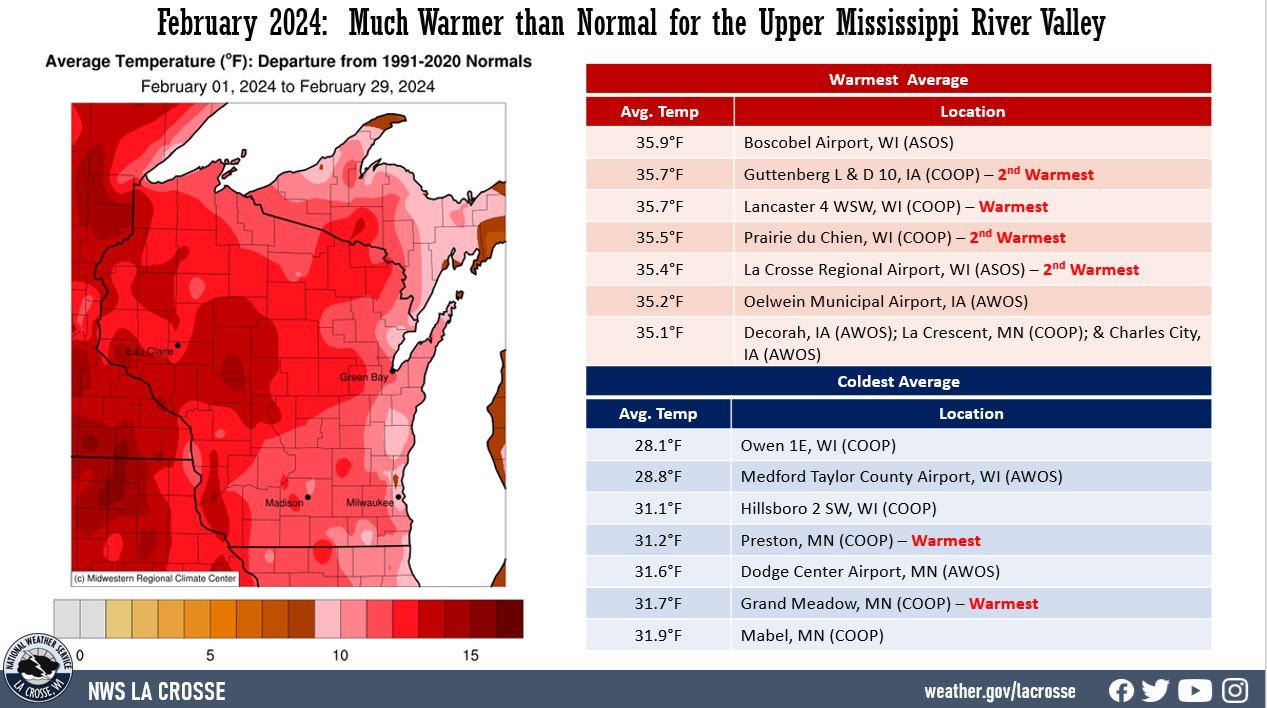 |
There was a 77°F difference between the warmest and coldest temperatures in the Upper Mississippi River Valley. The warmest temperature was 75°F at Northeast Iowa Regional Airport and Oelwein Municipal Airport on February 26. Meanwhile, the coldest temperature was -2°F at Theilman, MN (COOP) on February 29.
Precipitation - Below Normal
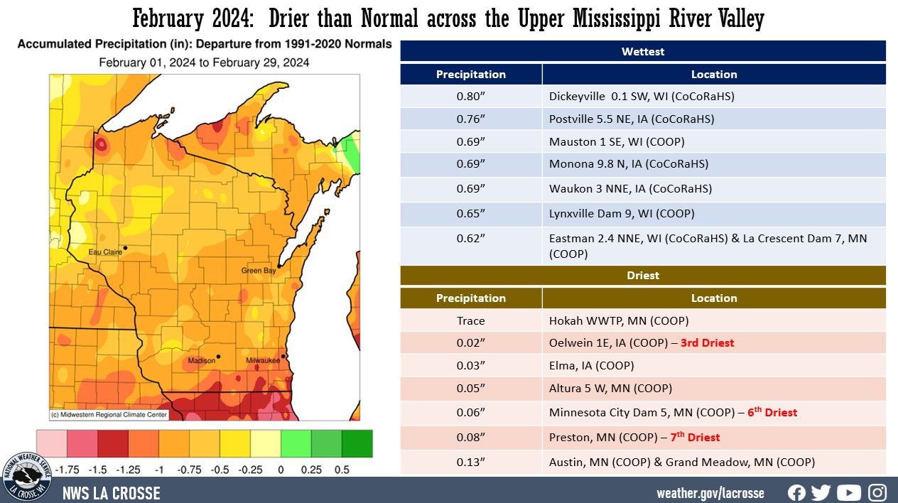
| Precipitation totals varied from just a trace at Hokah, MN (COOP) to 0.80" near Dickeyville, WI (CoCoRaHS). Precipitation anomalies ranged from 0.25" to 1.25" drier than normal. The highest one-day precipitation was 0.75" near Postville, IA (COOP) from February 14 through February 15. February 2024 will go down in the record books as the 3rd driest near Oelwein, IA; 6th driest at Minnesota City, MN; 7th driest at Preston, MN; and 10th driest at Rochester, MN. Abnormally dry (D0) to moderate (D1) drought continues north of Interstate 90, and abnormally dry (D0) to extreme (D3) drought lingers elsewhere. |
 |
Snowfall - Below Normal
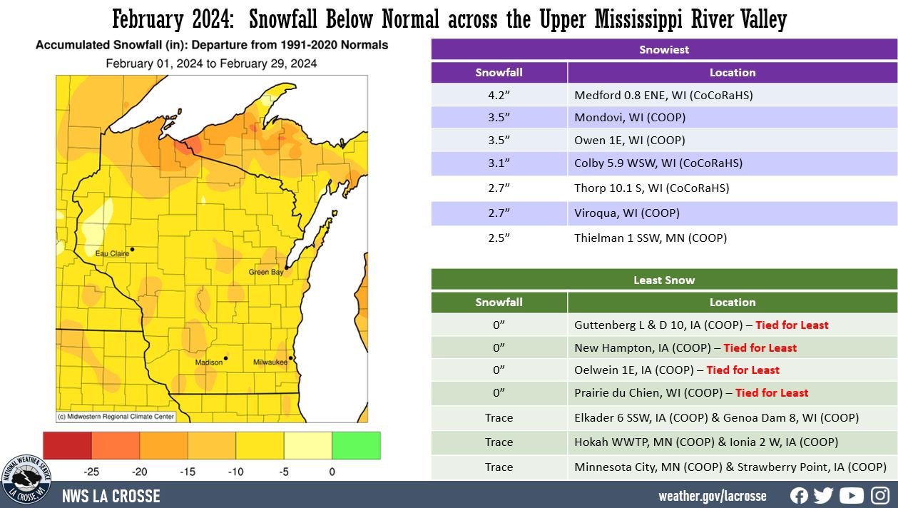
| Snowfall varied from 0" of snow at Guttenberg, IA; New Hampton, IA; Oelwein, IA; and Prairie du Chien, WI to 4.2" near Medford, WI (CoCoRaHS). Snowfall anomalies ranged from 5 to 15" below normal. The highest one-day snowfall was 3.8" at Medford 0.8 ENE, WI (CoCoRaHS) from February 14 to February 15. |
 |
Below are the February 2024 climate summaries for La Crosse, WI, and Rochester, MN.
La Crosse, WI
Very Dry and Warm February in La Crosse, WI
...February 2024 Highlights...
Temperatures - 2nd Warmest
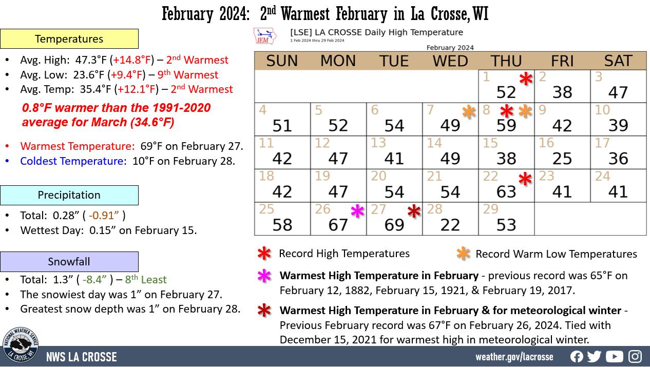
- During February 2024, the average temperature was 35.4°F at La Crosse Regional Airport. This was 12.1°F warmer than the 1991-2020 normal of 23.3°F. This was the 2nd warmest February. Only 1878 was warmer with an average temperature of 36.7°F. The average temperature this month was 0.8°F warmer than the 1991-2020 average for March (34.6°F).
|
 |
- Below are the 10 warmest Februarys.
Warmest Februarys
in La Crosse WI
1873-2024
Average
Rank Temperature Year
---- ----------- ----
1 36.7°F 1878
2 35.4°F 2024
3 34.2°F 1877
4 34.1°F 1998
5 33.7°F 1882
6 33.3°F 2017
7 32.8°F 1954
8 32.5°F 1931
9 31.2°F 1999
31.2°F 1987
- The average high temperature was 47.3°F. This was 14.8°F warmer than the 1991-2020 normal of 32.5°F. This was 3°F warmer than the previous record of 44.3°F in 1878. It was also 2.7°F warmer than the 1991-2020 average for March (44.6°F).
- The average low temperature was 23.6°F. This was 9.4°F warmer than the 1991-2020 normal of 14.2°F. This was the 9th warmest.
- The warmest high temperature was 69°F on February 27. This was the warmest ever for February. It also tied December 15, 2021, for the warmest temperature in meteorological winter.
- The coldest high temperature was 22°F on February 28.
- The warmest low temperature was 42°F on February 8.
- The coldest low temperature was 10°F on February 28.
Precipitation - Tied for 14th driest February
- The total precipitation was 0.28". This was 0.91" drier than the 1991-2020 normal of 1.19". This was tied for the 14th driest February in 1885.
- The wettest day was 0.15" on February 15.
- Measurable precipitation fell on 4 days (13.8%) and a trace of precipitation fell on another 4 days (13.8%).
Snowfall - 8th Least
- The total snowfall was 1.3". This was 8.4" below the 1991-2020 normal of 9.7". This was the 8th least. Below are the 10 least amount of snow in February.
Least Snow in February
in La Crosse WI
1897-2024
Rank Snowfall Year
---- -------- ----
1 0.5 inches 1954
2 0.6 inches 1958
3 0.8 inches 1969
0.8 inches 1968
5 1.0 inch 1964
6 1.2 inches 1996
1.2 inches 1947
8 1.3 inches 2024
9 1.7 inches 1984
10 2.2 inches 1995
2.2 inches 1982
- The snowiest day was 1" on February 27.
- Measurable snow fell on 2 days (6.9%) and a trace of snow fell on another 3 days (10.3%).
Snow Depth - Tied for the least in February
- The average snow depth was 0". This was 5.1" below the 1883-2024 average. This was tied with 1964 and 1968 for the least amount of snow.
- The greatest snow depth was 1" on February 28.
- Measurable snow was on the ground for 1 day (3.4%) and trace amounts on 3 days (10.3%).
...Records...
Daily...
- February 1 - Record High - 52°F - Previous record 48°F in 1931
- February 7 - Warm Low - 36°F - Previous record 35°F in 1970
- February 8 - Record High - 59°F - Previous record 51°F in 2002
- February 8 - Warm Low - 42°F - Previous record 36°F in 1938
- February 22 - Record High Tied - 63°F - Tied with 2017
- February 26 - Record High - 67°F - Previous record 61°F in 1976
- February 27 - Record High - 69°F - Previous record 62°F in 2016
Monthly...
- Warmest Average High Temperature - 47.3°F - Previous record was 44.3°F in 1878.
- February 26 - Warmest February Temperature - 67°F - Previous record was 65°F on February 12, 1882, February 15, 1921, and February 19, 2017.
- February 27 - Warmest February Temperature - 69°F - Previous record was 62°F on February 26, 2023
Seasonal...
- February 27 - Tied Warmest Meteorological Winter Temperature - 69°F - The last time this occurred was on December 15, 2021.
...Looking Ahead to March...
- The normal high temperature in La Crosse starts at 38°F on March 1st and warms to 53°F by the end of the month. The normal low temperature starts at 20°F on the 1st and warms to 32°F by the end of the month. The warmest March temperature on record is 84°F on March 29, 1986; and the coldest is -28°F on March 1, 1962.
- The normal mean temperature for March is 35.8°F. La Crosse’s warmest March occurred in 2012 with an average temperature of 50.4°F, and their coldest March occurred in 1899 with an average temperature of 21.3°F.
- The normal March precipitation is 2.04". The wettest March occurred in 1876 with 4.23" of precipitation and the driest occurred in 1910 with just 0.03". The wettest March day occurred on March 27, 1880, when 2.01" of precipitation fell. Normally, there is 1 day with thunderstorms.
- The normal March snowfall is 7.3" (4th snowiest month). The snowiest March occurred in 1959 with 33.5" of snow and the least snow was no snow in 2010. The snowiest March day occurred on March 13, 1997, when 14.3" of snow fell.
Rochester, MN
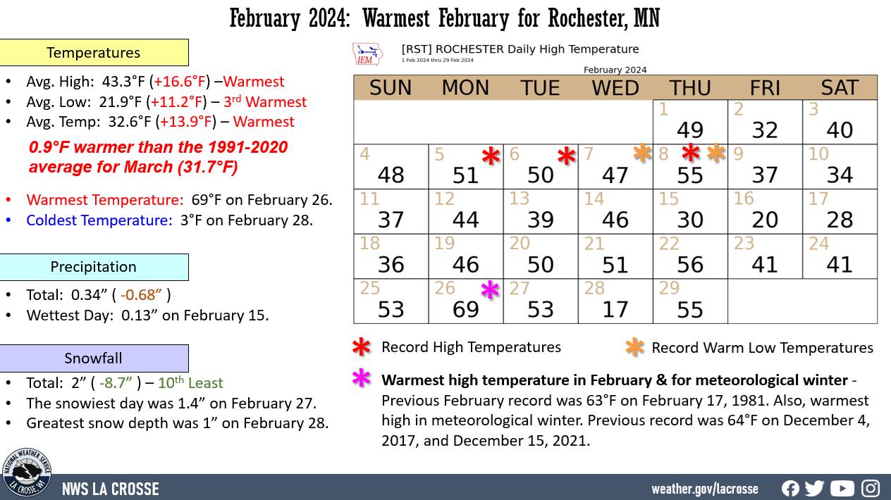
Warmest February in Rochester, MN
...February 2024 Highlights...
Temperatures - Warmest February
- During February 2024, the average temperature was 32.6°F at Rochester International Airport. This was 13.9°F warmer than the 1991-2020 normal of 18.7°F. This was the warmest February. The previous record was 32°F in 1931. The average temperature this month was 0.9°F warmer than the 1991-2020 average for March (31.7°F).
|
 |
- Below are the 10 warmest Februarys.
Warmest Februarys
in Rochester MN
1886-2024
Average
Rank Temperature Year
---- ----------- ----
1 32.6°F 2024
2 32.0°F 1931
3 31.8°F 1954
4 29.4°F 1998
5 29.3°F 1987
6 28.7°F 1930
7 28.2°F 1976
8 27.7°F 2012
9 27.6°F 2017
10 26.7°F 1992
- The average high temperature was 43.3°F. This was 16.6°F warmer than the 1991-2020 normal of 26.7°F. The previous record was 42.9°F in 1931. It was also 3.4°F warmer than the 1991-2020 average for March (39.9°F).
- The average low temperature was 21.9°F. This was 11.2°F warmer than the 1991-2020 normal of 10.7°F. This was the 3rd warmest. The only 2 Februarys which were warmer were 1998 (23.6°F) and 1954 (23.1°F).
- The warmest high temperature was 69°F on February 26. This was the warmest ever for February. The previous record was 63°F on February 17, 1981. It was also the warmest temperature for meteorological winter. The previous record was 64°F on December 4, 2017, and December 15, 2021.
- The coldest high temperature was 17°F on February 28.
- The warmest low temperature was 36°F on February 8.
- The coldest low temperature was 3°F on February 28.
Precipitation - Below Normal
- The total precipitation was 0.34". This was 0.68" drier than the 1991-2020 normal of 1.02".
- The wettest day was 0.13" on February 15.
- Measurable precipitation fell on 4 days (13.8%) and a trace of precipitation fell on another 2 days (6.9%).
Snowfall - 10th Least
- The total snowfall was 2". This was 8.7" below the 1991-2020 normal of 10.7". This was the 10th least. Below are the 10 least amount of snow in February.
Least Snow in February
in Rochester MN
1886-2024
Rank Snowfall Year
---- -------- ----
1 0.2 inches 1954
2 0.6 inches 1958
3 0.7 inches 1912
4 0.8 inches 1964
0.8 inches 1910
6 1.4 inches 1995
7 1.6 inches 1976
8 1.8 inches 1977
9 1.9 inches 1996
10 2.0 inches 2024
- The snowiest day was 1.4" on February 27.
- Measurable snow fell on 3 days (10.3%) and a trace of snow fell on another day (3.4%).
Snow Depth - Tied for the least in February
- The average snow depth was 0". This was 6" below the 1912-2024 average. This was tied with 1913 and 1964 for the least amount of snow.
- The greatest snow depth was 1" on February 28.
- Measurable snow was on the ground for 1 day (3.4%) and trace amounts on another 2 days (6.9%).
...Records...
Daily...
- February 5 - Record High - 51°F - Previous record 48°F in 1946
- February 6 - Record High - 50°F - Previous record 43°F in 1987
- February 7 - Warm Low - 35°F - Previous record 48°F in 1894
- February 8 - Record High - 55°F - Previous record 49°F in 2002
- February 8 - Warm Low - 36°F - Previous record 34°F in 1966
- February 26 - Record High - 69°F - Previous record 58°F in 1958
Monthly...
- Warmest Average Temperature - 32.6°F - Previous record 32°F in 1931
- Warmest Average High for February - 43.3°F - Previous record 42.9°F in 1931
- February 26 - Warmest February Temperature - 69°F - Previous record was 63°F on February 17, 1981.
Seasonal...
- February 26 - Warmest Meteorological Winter Temperature - 69°F - Previous record was 64°F on December 4, 2017, and December 15, 2021.
...Looking Ahead to March...
- The normal high temperature in Rochester starts at 32°F on March 1st and warms to 48°F by the end of the month. The normal low temperature starts at 17°F on the 1st and warms to 30°F by the end of the month. The warmest March temperature on record is 82°F on March 24, 1910; and the coldest is -31°F on March 1, 1962.
- The normal mean temperature for March is 31.7°F. Rochester’s warmest March occurred in 2012 with an average temperature of 49.1°F, and its coldest March occurred in 1888 with an average temperature of 17.4°F.
- The normal March precipitation is 2.02". The wettest March occurred in 1888 with 4.02" of precipitation and the driest occurred in 1910 with just a trace of precipitation. The wettest March day occurred on March 22, 2011, when 2.20" of precipitation fell. Normally, there is 1 day with thunderstorms.
- The normal March snowfall is 8.6" (4th snowiest month). The snowiest March occurred in 1951 with 35.1" of snow and the least snow was no snow in 2010. The snowiest March day occurred on March 18, 2005, when 19.8" of snow fell.


 Weather Story
 Weather Map
 Local Radar