
Strong to severe storms are expected to develop from mid afternoon through early evening. Damaging winds will be the main threat, but large hail and tornadoes are also possible. Have multiple ways to receive warnings and stay weather aware if you have outdoor plans. Read More >
Overview
|
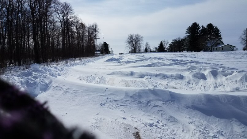
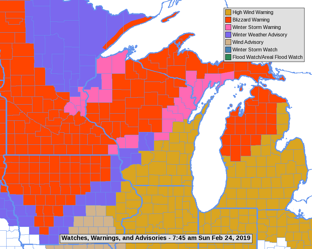
A strong winter storm brought heavy snow and very strong winds to much of the area from Saturday evening (Feb 23rd) through Sunday (Feb.24th). The combination of snow and wind resulted in blizzard conditions across northeast Iowa into north-central Wisconsin. Precipitation moved in Saturday evening, starting out as a rain and wintry mix, then gradually changing to snow from west to east as the night continued. The heaviest snows, in places over a foot, fell along an Austin, MN to the Medford, WI line. The snow came down fast, from 1 to 3" per hour at times. The bulk of the accumulations occurred by 6 am Sunday for locations south of I-94, lingering further north through the noon hour. As the snow was ending, winds started ramping up. Sustained northwest winds around 30 mph were common across the open areas of southern Minnesota and northeast Iowa - gusting upwards of 55 mph! These winds spread east into western Wisconsin later in the morning, persisting through the afternoon. The strong winds and heavy snow created blizzard conditions and major drifting across much of northeast Iowa, southeast Minnesota and into north-central Wisconsin. White-outs in open areas were common. There were numerous road closures (including Interstate 90) along with some tow bans. |
 Radar loop (February 23-24, 2019) |
Peak Wind Reports:
 |
|
Loop of the higher wind gust area Saturday evening |
PUBLIC INFORMATION STATEMENT
NATIONAL WEATHER SERVICE LA CROSSE WI
723 PM CST SUN FEB 24 2019

...PEAK WIND GUSTS TODAY...

LOCATION                     SPEED     TIME/DATE       LAT/LON
ROCHESTER INTERNATIONAL AIRP 58 MPH    1226 PM 02/24   43.91N/92.50W
2 W OELWEIN                  55 MPH    0155 PM 02/24   42.68N/91.97W
OELWEIN MUNICIPAL AIRPORT    55 MPH    0155 PM 02/24   42.68N/91.97W
PLATTEVILLE MUNICIPAL AIRPOR 55 MPH    1155 AM 02/24   42.69N/90.44W
MAYO HELIPAD                 54 MPH    1255 PM 02/24   44.02N/92.48W
1 ENE DEXTER                 54 MPH    0135 PM 02/24   43.73N/92.68W
BYRON                        52 MPH    0115 PM 02/24   44.04N/92.64W
3 N STEWARTVILLE             52 MPH    0205 PM 02/24   43.90N/92.48W
2 NNW ZUMBRO FALLS           51 MPH    0203 PM 02/24   44.32N/92.44W
CHARLES CITY AIRPORT         51 MPH    0155 PM 02/24   43.07N/92.61W
DECORAH MUNICIPAL AIRPORT    51 MPH    1255 PM 02/24   43.28N/91.74W
2 E KASSON                   51 MPH    0520 PM 02/24   44.02N/92.71W
1 SSE KELLOGG                49 MPH    0915 AM 02/24   44.28N/91.99W
5 NW FRANKVILLE              49 MPH    0132 PM 02/24   43.25N/91.70W
DODGE CENTER AIRPORT         49 MPH    0115 PM 02/24   44.02N/92.83W
AUSTIN MUNICIPAL AIRPORT     48 MPH    1256 PM 02/24   43.66N/92.93W
PRAIRIE DU CHIEN  AIRPORT    48 MPH    1115 AM 02/24   43.02N/91.12W
2 N IONIA                    48 MPH    1040 AM 02/24   43.07N/92.46W
2 SE DOUGLAS                 47 MPH    1145 AM 02/24   44.08N/92.55W
LA CROSSE REGIONAL AIRPORT   47 MPH    1227 PM 02/24   43.88N/91.26W
MEDFORD AIRPORT              47 MPH    1255 PM 02/24   45.10N/90.30W
2 SE EYOTA                   47 MPH    0520 PM 02/24   43.96N/92.21W
BOSCOBEL AIRPORT             47 MPH    0250 PM 02/24   43.16N/90.67W
MAUSTON AIRPORT              45 MPH    1055 AM 02/24   43.84N/90.14W
BLACK RIVER FALLS AREA AIRPO 44 MPH    0355 PM 02/24   44.25N/90.86W
1 E BLACK RIVER FALLS        40 MPH    0315 PM 02/24   44.30N/90.83W
3 NE LUBLIN                  39 MPH    0514 PM 02/24   45.11N/90.69W
PRESTON AIRPORT              39 MPH    0255 PM 02/24   43.68N/92.18W
WINONA MUNICIPAL AIRPORT     39 MPH    0115 PM 02/24   44.08N/91.71W
1 ENE BOSCOBEL               38 MPH    1103 AM 02/24   43.15N/90.68W
SPARTA/FORT MCCOY AIRPORT    37 MPH    0235 PM 02/24   43.96N/90.74W
2 NNE ROCHESTER              37 MPH    0210 PM 02/24   44.05N/92.45W
2 E CATARACT                 36 MPH    0403 PM 02/24   44.09N/90.79W
3 SW HAMMOND                 36 MPH    0246 PM 02/24   44.18N/92.41W
3 W SAINT JOSEPH             34 MPH    0654 PM 02/24   43.78N/91.10W
LAKE CITY                    32 MPH    1245 PM 02/24   44.45N/92.27W

OBSERVATIONS ARE COLLECTED FROM A VARIETY OF SOURCES WITH VARYING
EQUIPMENT AND EXPOSURES. WE THANK ALL VOLUNTEER WEATHER OBSERVERS
FOR THEIR DEDICATION. NOT ALL DATA LISTED ARE CONSIDERED OFFICIAL.
Snow Reports
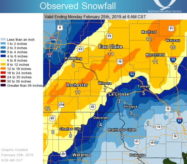
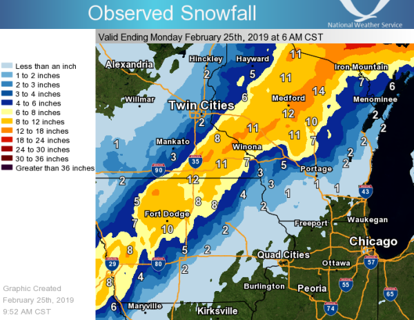
...FEBRUARY 23-24 SNOWFALL REPORTS...

Location                     Amount    Time/Date       Lat/Lon

...Iowa...

...Allamakee County...
Lansing                      1.5 in    1003 AM 02/24   43.36N/91.22W
5 NE Postville               1.5 in    0700 AM 02/25   43.14N/91.49W

...Chickasaw County...
New Hampton                  8.0 in    0800 AM 02/25   43.06N/92.31W
Ionia 2W                     7.0 in    0700 AM 02/24   43.03N/92.50W

...Clayton County...
Strawberry Point             1.0 in    0700 AM 02/24   42.69N/91.53W
Volga 1NE                    0.8 in    0615 AM 02/25   42.81N/91.52W
Elkader 6SSW                 0.5 in    0700 AM 02/24   42.78N/91.45W

...Fayette County...
Fayette                      1.5 in    0700 AM 02/25   42.85N/91.82W

...Floyd County...
Nora Springs 2.4 SSE         8.0 in    0700 AM 02/24   43.11N/92.99W
Charles City                 7.4 in    0700 AM 02/25   43.06N/92.67W
Marble Rock                  7.0 in    0739 AM 02/24   42.96N/92.87W
Nashua 2SW                   6.0 in    0700 AM 02/24   42.94N/92.57W

...Howard County...
Elma                         7.0 in    0700 AM 02/25   43.24N/92.44W

...Mitchell County...
Carpenter                    12.0 in   0546 PM 02/24   43.41N/93.02W
St Ansgar                    9.2 in    0630 AM 02/24   43.38N/92.92W

...Winneshiek County...
3 NNW Decorah                4.5 in    0821 AM 02/24   43.34N/91.83W
Decorah                      3.5 in    0600 PM 02/24   43.30N/91.80W
Calmar NE                    3.4 in    0700 AM 02/25   43.19N/91.86W
7 ENE Decorah                2.5 in    0730 AM 02/25   43.34N/91.64W

...Minnesota...

...Dodge County...
2 NE Kasson                  13.0 in   0700 AM 02/24   44.05N/92.72W
Hayfield                     11.5 in   0830 AM 02/24   43.89N/92.85W

...Fillmore County...
Chatfield                    12.0 in   0750 AM 02/24   43.85N/92.18W
Rushford                     10.5 in   0704 AM 02/24   43.81N/91.75W
1 S Peterson                 9.8 in    0942 AM 02/24   43.77N/91.83W
1 SSE Pilot Mound            9.1 in    0700 AM 02/24   43.79N/92.03W
Fountain                     9.0 in    0756 AM 02/24   43.74N/92.13W
Spring Valley                8.6 in    0700 AM 02/24   43.69N/92.39W
Mabel                        5.0 in    0630 AM 02/25   43.52N/91.76W

...Houston County...
Caledonia                    5.5 in    0734 AM 02/24   43.64N/91.50W
Hokah 4NW                    4.4 in    0608 AM 02/24   43.80N/91.43W
4 NNE Houston                4.0 in    0545 AM 02/24   43.80N/91.53W
Spring Grove                 4.0 in    1126 AM 02/24   43.56N/91.64W
4 NW Eitzen                  3.5 in    0800 AM 02/24   43.56N/91.51W
3 W Stoddard                 2.6 in    0600 AM 02/25   43.65N/91.28W

...Mower County...
2 NE Lansing                 12.5 in   0125 PM 02/24   43.76N/92.95W
1 SW Austin                  11.3 in   0100 PM 02/24   43.66N/92.98W
2 SW Austin                  10.5 in   0810 AM 02/24   43.65N/92.99W
Austin                       10.5 in   0831 AM 02/24   43.67N/92.97W
4 WSW Austin                 9.0 in    0755 AM 02/24   43.64N/93.05W

...Olmsted County...
2 SSW Rochester              14.3 in   0704 PM 02/24   43.99N/92.49W
2 NNW Rochester              13.5 in   0700 AM 02/24   44.05N/92.49W
4 W Potsdam                  12.5 in   0937 AM 02/24   44.16N/92.43W
1 SSW Oronoco                12.5 in   0213 PM 02/24   44.15N/92.54W
6 E Douglas                  11.0 in   0715 AM 02/24   44.10N/92.46W
2 NE Rochester               11.0 in   0600 AM 02/25   44.04N/92.44W
4 ESE Douglas                10.9 in   0745 AM 02/24   44.08N/92.51W
Rochester International Airp 10.5 in   0554 AM 02/25   43.91N/92.50W
1 NNW Rochester              10.2 in   1002 AM 02/24   44.02N/92.48W
Elgin 2SSW                   10.1 in   0700 AM 02/25   44.10N/92.27W
2 S Predmore                 10.0 in   0727 AM 02/24   43.90N/92.34W
3 ESE Douglas                10.0 in   0757 AM 02/24   44.09N/92.51W
2 SW Predmore                10.0 in   0925 AM 02/24   43.92N/92.35W

...Wabasha County...
Theilman 1SSW                12.2 in   0730 AM 02/25   44.28N/92.19W
2 N Kellogg                  12.0 in   0730 AM 02/24   44.34N/92.01W
Wabasha                      11.0 in   0448 AM 02/24   44.37N/92.04W
3 SW Zumbro Falls            9.3 in    0745 AM 02/24   44.24N/92.46W

...Winona County...
Minnesota City               13.5 in   0602 PM 02/24   44.09N/91.75W
1 NW Goodview                12.5 in   1004 AM 02/24   44.07N/91.72W
Lewiston                     12.0 in   0721 AM 02/24   43.99N/91.86W
1 N Pickwick                 12.0 in   1106 AM 02/24   43.99N/91.60W
1 WSW Winona                 11.0 in   1015 AM 02/24   44.03N/91.68W
Rollingstone                 10.5 in   0359 PM 02/24   44.10N/91.82W
Winona                       10.0 in   0542 AM 02/24   44.05N/91.66W
Winona 4SW                   8.0 in    1035 AM 02/24   43.98N/91.71W
La Crescent Dam 7            2.5 in    0800 AM 02/24   43.87N/91.31W

...Wisconsin...

...Adams County...
Friendship                   6.2 in    0700 AM 02/25   43.98N/89.83W
8 ENE Friendship             3.2 in    0835 AM 02/24   44.01N/89.66W
2 S Brooks                   3.0 in    1000 AM 02/24   43.79N/89.64W

...Buffalo County...
Alma                         12.0 in   1053 AM 02/24   44.32N/91.91W
5 NE Montana                 11.5 in   0747 AM 02/24   44.40N/91.61W
Mondovi                      11.0 in   0600 PM 02/24   44.56N/91.67W

...Clark County...
Withee                       10.0 in   1245 PM 02/24   44.95N/90.59W
Colby 6SW                    10.0 in   0844 PM 02/24   44.87N/90.42W
3 SW Spencer                 7.0 in    0725 AM 02/24   44.71N/90.34W

...Crawford County...
Steuben 4SE                  3.0 in    0700 AM 02/25   43.13N/90.84W
De Soto 1SE                  2.3 in    0635 AM 02/24   43.42N/91.19W
Gays Mills                   1.0 in    0700 AM 02/24   43.32N/90.85W
Lynxville Dam 9              1.0 in    0800 AM 02/24   43.21N/91.10W
Eastman                      1.0 in    0729 PM 02/24   43.16N/91.02W
Prairie Du Chien             1.0 in    0700 AM 02/25   43.05N/91.13W

...Grant County...
1 W Platteville              2.0 in    1030 AM 02/24   42.74N/90.49W
Muscoda                      0.8 in    0945 AM 02/24   43.18N/90.44W
Cuba City                    0.5 in    0600 AM 02/24   42.61N/90.43W

...Jackson County...
Hatfield                     8.0 in    0723 AM 02/24   44.41N/90.73W
Black River Falls 1.7 NNE    6.2 in    0700 AM 02/24   44.32N/90.83W
Black River Falls Sewage     5.3 in    0830 AM 02/24   44.29N/90.85W
5 E Irving                   4.0 in    0200 PM 02/24   44.19N/90.80W

...Juneau County...
Mauston 1se                  3.0 in    0800 AM 02/24   43.79N/90.06W
Union Center                 2.0 in    0700 AM 02/25   43.68N/90.26W

...La Crosse County...
1 N New Amsterdam            6.0 in    0718 AM 02/24   44.01N/91.31W
Holmen                       4.5 in    0617 AM 02/24   43.96N/91.26W
Holmen 2S                    3.8 in    0700 AM 02/24   43.93N/91.25W
1 WSW West Salem             3.6 in    0741 AM 02/24   43.90N/91.10W
La Crosse 4NNW               2.6 in    0730 AM 02/25   43.87N/91.27W
La Crosse Regional Airport   2.5 in    0553 AM 02/24   43.88N/91.26W
La Crosse Weather Office     2.3 in    0600 AM 02/25   43.82N/91.19W

...Monroe County...
Warrens 4WSW                 4.4 in    0700 AM 02/25   44.10N/90.59W
Sparta                       3.8 in    0800 AM 02/25   43.94N/90.82W
Cashton 3NNW                 3.5 in    0747 AM 02/25   43.79N/90.80W

...Richland County...
Richland Center 4N           1.0 in    0700 AM 02/25   43.40N/90.39W

...Taylor County...
2 N Dorchester               12.5 in   1122 AM 02/24   45.04N/90.34W
1 W Medford                  12.0 in   0925 AM 02/24   45.14N/90.37W
2 S Gilman                   10.0 in   0943 AM 02/24   45.14N/90.80W
Medford                      10.0 in   0800 AM 02/25   45.13N/90.34W
Jump River 1 NW              8.0 in    0700 AM 02/24   45.36N/90.80W

...Trempealeau County...
Independence 3NE             16.0 in   0846 AM 02/24   44.39N/91.39W
Eleva                        13.0 in   0730 AM 02/24   44.58N/91.47W
Osseo                        12.0 in   0700 AM 02/24   44.58N/91.22W
Whitehall                    12.0 in   1024 AM 02/24   44.37N/91.32W
Ettrick 4WNW                 7.4 in    0705 AM 02/25   44.19N/91.34W
Trempealeau Dam 6            7.0 in    0800 AM 02/25   44.00N/91.44W
Ettrick                      6.0 in    0636 AM 02/24   44.17N/91.27W

...Vernon County...
Viroqua 0.8 ESE              4.5 in    0700 AM 02/25   43.55N/90.87W
La Farge                     3.7 in    0700 AM 02/25   43.57N/90.64W
Westby 3ENE                  3.4 in    0700 AM 02/25   43.67N/90.81W
3 NE Stoddard                2.5 in    0756 AM 02/24   43.69N/91.18W
3 WNW Viola                  2.5 in    0800 AM 02/25   43.53N/90.74W
Stoddard                     2.4 in    0700 AM 02/25   43.66N/91.22W
Viroqua                      2.2 in    0700 AM 02/24   43.56N/90.88W
Stoddard 5NNE                2.2 in    0700 AM 02/24   43.72N/91.17W
Hillsboro 2SW                2.0 in    0700 AM 02/24   43.63N/90.38W
Genoa Dam 8                  2.0 in    0800 AM 02/25   43.57N/91.23W
Hillsboro WSW                1.4 in    0700 AM 02/25   43.65N/90.35W

Observations are collected from a variety of sources with varying
equipment and exposures. We thank all volunteer weather observers
for their dedication. Not all data listed are considered official.
Photos:
 |
 |
 |
 |
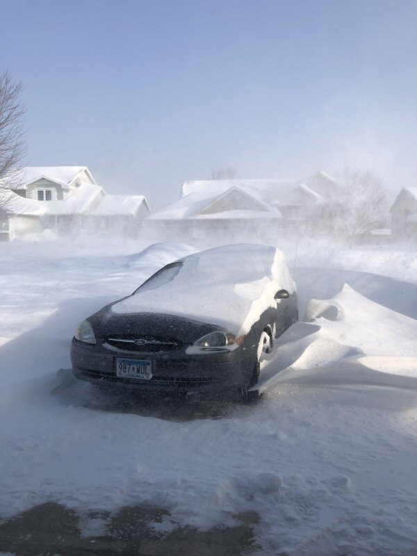
| Kasson, MN (Photo by Amy Evans) |
Rochester, MN (Photo by ABC 6 News/KAAL TV) |
Rochester, MN (Photo by ABC 6 News/KAAL TV) |
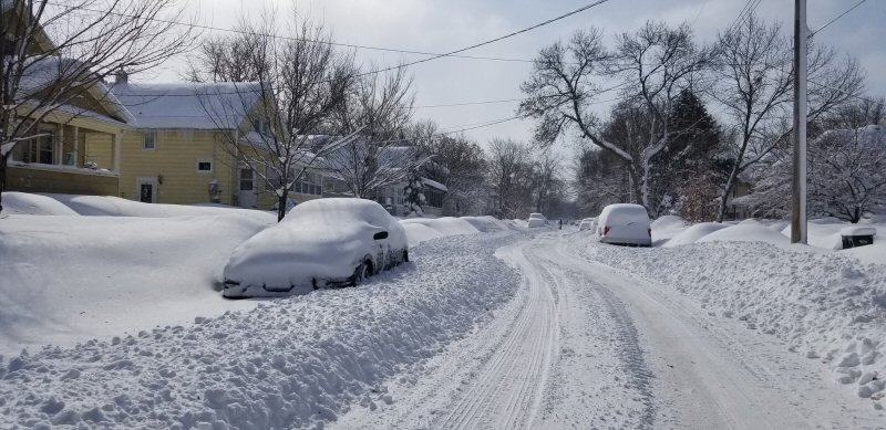
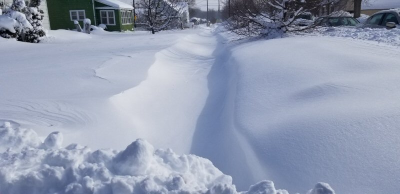
West Salem, WI (Photo by Jeff Boyne) |
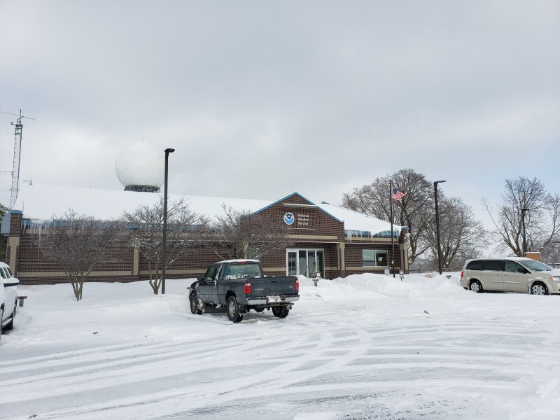 |
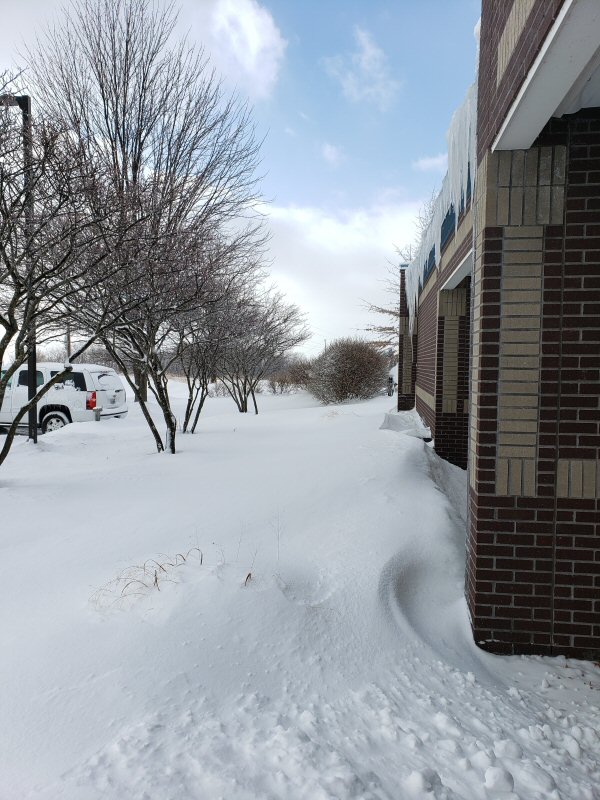 |
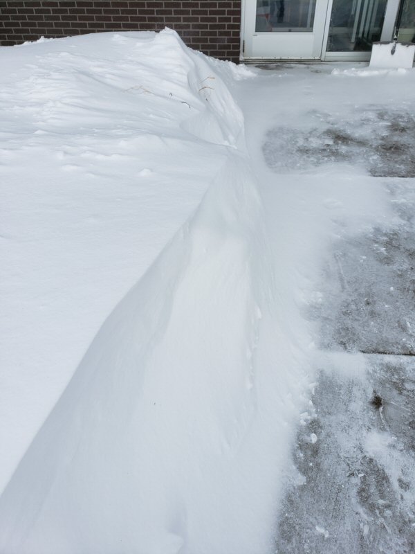 |
|
| NWS La Crosse | NWS La Crosse | NWS La Crosse | |
 |
 |
 |
|
| MNDOT camera montage over southeast Minnesota Sunday | IADOT plowcam montage over southeast Minnesota Sunday |
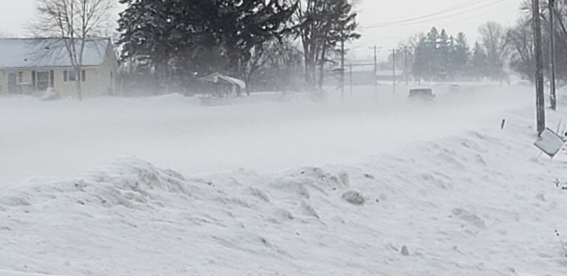
Between Dorchester and Stetsonville, WI |
Radar:
 |
||
| Dual-pol radar loop showing the conversion of a wintry mix (yellows) to all snow (red) Saturday evening. The conversion occurs from the west and south. |
Environment / Services / Road Conditions
 |
 |
 |
| Surface low and winds (6 pm Feb 23 through 3 pm Feb 34) | Warnings & Advisories issued for storm | Loop of Warnings & Advisories issued for storm from Thursday through Sunday |
 |
 |
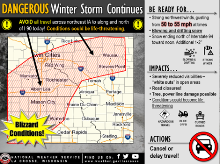 |
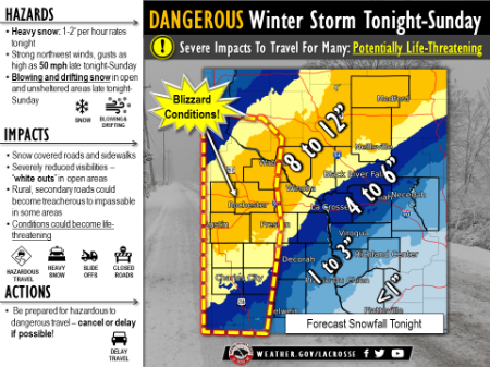
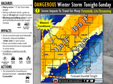
| 500 am Saturday: Weather Story from the NWS La Crosse website |
330 pm:Saturday: Weather Story ​ from the NWS La Crosse website |
500 am Sunday: Weather Story ​ from the NWS La Crosse website |
 |
||
| Change in Minnesota road conditions Sunday morning (MNDOT) |
 |
Media use of NWS Web News Stories is encouraged! Please acknowledge the NWS as the source of any news information accessed from this site. |
|


 Weather Story
 Weather Map
 Local Radar