Overview
|
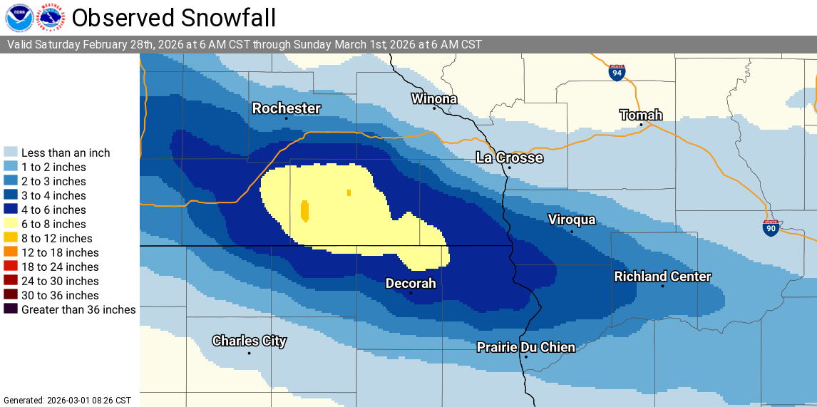
An extremely narrow band of intense snow fell across southeast Minnesota and southwestern Wisconsin, clipping far northeast Iowa, during the day on Sat, February 28, 2026. The highest reports ranged from 6" to 10" in a narrow 20-mile swath that started back in far eastern South Dakota and spanned southern Minnesota before weakening in south-central Wisconsin. While snow amounts were quite impressive, even more impressive was the fluffy nature of the snow with snow liquid ratios (what 1" of water would translate to in snow depth) of 30-50:1! Our average SLR is usually between 10-15:1. The narrow nature of the snow band, coupled with an environment that teetered on being too dry, made for an exceptionally challenging forecast. Confidence was high many days in advance that we would see a narrow band of intense snow rates (1-2"/ hr), but even the night before, the lingering question was: exactly where and for how long? A difference of even a few hours and a few miles could mean the difference between a dusting of snow and 6+ inches. The ingredients aligned perfectly for this unique event to play out as it did. |
 Radar Animation from 4am-4pm CST on Feb 28, 2026 |
Snow
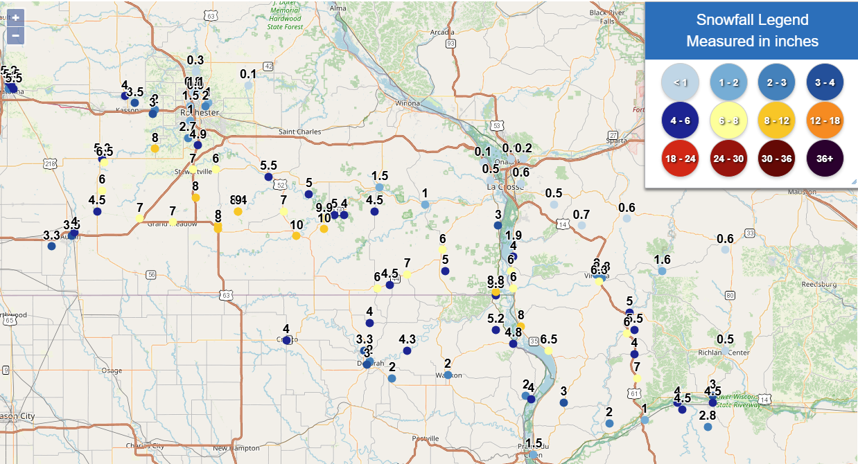
Across the local area, a narrow band of 6" to 10" of snow was observed from Hayfield, MN through New Albin, IA and into Mount Zion, WI.
 |
 |
| Individual Snow Reports | Interpolated Map of Snow Reports |
Location                     Amount    Time/Date       Provider

...Iowa...

...Allamakee County...
New Albin                    5.5 in    0235 PM 02/28   Public
Lansing 4.1 NW               5.2 in    0700 AM 03/01   COCORAHS
Lansing                      4.8 in    0245 PM 02/28   Public
Harpers Ferry                4.0 in    0352 PM 02/28   Public
Waukon                       2.0 in    0127 PM 02/28   Public
1 NW Harpers Ferry           2.0 in    0137 PM 02/28   Public
Harpers Ferry 6.4 SSW        1.9 in    0700 AM 03/01   COCORAHS

...Howard County...
Cresco                       4.0 in    0350 PM 02/28   Public

...Winneshiek County...
7 ENE Decorah                4.3 in    0733 AM 03/01   COCORAHS
6 ENE Bluffton               4.0 in    0218 PM 02/28   Public
2 NNW Decorah                3.3 in    0332 PM 02/28   Public
Decorah                      3.0 in    0510 PM 02/28   COOP
Decorah 4.9SE                2.0 in    0700 AM 03/01   COCORAHS

...Minnesota...

...Dodge County...
Hayfield                     8.0 in    0236 PM 02/28   Public
Hayfield 0.7 SSE             6.5 in    0300 PM 02/28   COCORAHS
Hayfield 0.3 SSE             5.3 in    0630 AM 03/01   COCORAHS
Mantorville                  4.0 in    0325 PM 02/28   Public
Mantorville 1.9 ESE          3.5 in    0700 AM 03/01   COCORAHS

...Fillmore County...
Preston                      10.0 in   0203 PM 02/28   Public
2 S Lanesboro                10.0 in   0218 PM 02/28   Public
Lanesboro 0.2 SSW            9.9 in    0600 AM 03/01   COCORAHS
2 WSW Fillmore               9.0 in    0242 PM 02/28   Park/Forest Srvc
Wykoff 3.1 NW                8.4 in    0700 AM 03/01   COCORAHS
1 N Spring Valley            8.0 in    0232 PM 02/28   Public
Spring Valley                8.0 in    0325 PM 02/28   Public
Fountain                     7.0 in    0324 PM 02/28   Public
Spring Valley 0.9 NNW        6.1 in    0700 AM 03/01   COCORAHS
Mabel                        6.0 in    0700 AM 03/01   COOP
Chatfield                    5.5 in    0157 PM 02/28   Public
Chatfield 9.0 ESE            5.0 in    0700 AM 03/01   COCORAHS
Whalan                       5.0 in    0223 PM 02/28   Public
Bratsberg                    4.5 in    0340 PM 02/28   Public
2 E Whalan                   4.0 in    0116 PM 02/28   Public
Rushford                     1.5 in    0143 PM 02/28   Public

...Houston County...
6 S Reno                     8.8 in    0350 PM 02/28   Public
Spring Grove                 7.0 in    0233 PM 02/28   Public
Caledonia                    6.0 in    0123 PM 02/28   Public
4 NNW Eitzen                 5.0 in    0112 PM 02/28   Public
3 ENE Mabel                  4.5 in    0111 PM 02/28   Public
Brownsville                  3.0 in    0300 PM 02/28   Public
Hokah 4 NW                   1.2 in    0700 AM 03/01   COOP
1 ENE Mound Prairie          1.2 in    0700 AM 03/01   COCORAHS
Houston                      1.0 in    0144 PM 02/28   Public
La Crescent                  0.5 in    0117 PM 02/28   Public

...Mower County...
Racine                       8.0 in    0300 PM 02/28   Public
Grand Meadow                 7.0 in    0232 PM 02/28   Public
Dexter                       7.0 in    0325 PM 02/28   Public
Waltham 2.0 SE               6.0 in    0800 AM 03/01   COCORAHS
Brownsdale                   4.5 in    0202 PM 02/28   Public
1 NE Austin                  4.0 in    0351 PM 02/28   Public
Austin                       3.5 in    0224 PM 02/28   Public
4 WSW Austin                 3.3 in    0229 PM 02/28   Public

...Olmsted County...
Rock Dell                    8.0 in    0325 PM 02/28   Public
Stewartville                 7.0 in    0146 PM 02/28   Public
Stewartville 4.3 E           6.0 in    0600 AM 03/01   COCORAHS
Stewartville 0.8 E           5.5 in    0700 AM 03/01   COCORAHS
5 N Stewartville             4.9 in    0600 PM 02/28   CO-OP Observer
2 NE Rochester AP            4.9 in    0600 PM 02/28   CO-OP Observer
1 S Byron                    3.0 in    0159 PM 02/28   Public
5 SSW Rochester              2.7 in    1230 PM 02/28   Public
Rochester 3.9 ESE            2.3 in    0700 AM 03/01   COCORAHS
Byron 5.5 SE                 2.2 in    0730 AM 03/01   COCORAHS
2 NE Rochester               2.0 in    0530 AM 03/01   COCORAHS
Byron 0.4 SSE                2.0 in    0700 AM 03/01   COCORAHS
2 NNW Rochester              1.5 in    0132 PM 02/28
Rochester 4.7 N              1.1 in    0700 AM 03/01   COCORAHS
Rochester 1.5 WSW            1.0 in    0600 AM 03/01   COCORAHS
3 NE Rochester               1.0 in    0123 PM 02/28   Public
4 N Rochester                0.9 in    0120 PM 02/28   Trained Spotter
Rochester 4.2 N              0.8 in    0630 AM 03/01   COCORAHS
Oronoco 3.3 ESE              0.3 in    0700 AM 03/01   COCORAHS
Elgin 2SSW                   0.1 in    0700 AM 03/01   COOP

...Winona County...
La Crescent 4.0 NNW          0.1 in    0700 AM 03/01   COCORAHS

...Wisconsin...

...Adams County...
Oxford 4.0 W                 0.3 in    0700 AM 03/01   COCORAHS

...Crawford County...
1 S De Soto                  8.0 in    0600 AM 03/01   Public
Mount Zion                   7.0 in    0413 PM 02/28   Public
Ferryville                   6.5 in    0409 PM 02/28   Public
Soldiers Grove               6.0 in    0326 PM 02/28   Public
2 NW Clayton                 5.5 in    0317 PM 02/28   Public
4 SSW Clayton                4.0 in    0231 PM 02/28   Public
3 NNE Eastman                3.4 in    0845 AM 03/01   COCORAHS
2 N Eastman                  3.0 in    0134 PM 02/28   Public
Eastman                      2.8 in    0515 PM 02/28   Public
Steuben 4SE                  2.0 in    0724 AM 03/01   COOP
Prairie Du Chien             1.5 in    0230 PM 02/28   Public

...Grant County...
2 SE Blue River              4.5 in    0415 PM 02/28   Public
Muscoda                      4.5 in    0410 PM 02/28   Public
Blue River                   4.0 in    0335 PM 02/28   Public
4 S Muscoda                  2.8 in    0700 AM 03/01   COCORAHS
Boscobel                     1.0 in    0131 PM 02/28   Public

...La Crosse County...
2 E La Crosse                0.6 in    0600 PM 02/28   Official NWS Obs
Coon Valley 4.5 NNW          0.5 in    0700 AM 03/01   COCORAHS
2 E La Crosse                0.4 in    0203 PM 02/28   Official NWS Obs
La Crosse 1.5 SSE            0.2 in    0700 AM 03/01   COCORAHS
Onalaska 1.9 E               0.2 in    0700 AM 03/01   COCORAHS
Onalaska 0.5 WSW             0.1 in    0700 AM 03/01   COCORAHS
La Crosse 4NNW               0.1 in    0730 AM 03/01   COOP

...Richland County...
Richland Center 4.0 N        3.0 in    0800 AM 03/01   COCORAHS
1 N Muscoda                  3.0 in    0239 PM 02/28   Public
Richland Center              0.5 in    0130 PM 02/28   Public

...Vernon County...
1 SSE Viroqua                6.3 in    0223 PM 02/28
Genoa Dam 8                  6.0 in    0800 AM 03/01   COOP
3 N Victory                  6.0 in    0150 PM 02/28   Public
Readstown                    5.0 in    0250 PM 02/28   Public
3 N Genoa                    4.0 in    0156 PM 02/28   Public
0.5 E Viroqua                3.4 in    0700 AM 03/01   COOP
Genoa                        3.0 in    0142 PM 02/28   Public
Viroqua 0.8 ESE              2.8 in    0700 AM 03/01   COCORAHS
Viroqua                      2.0 in    0127 PM 02/28   Public
1 S Stoddard                 1.9 in    0315 PM 02/28   Public
La Farge                     1.6 in    0700 AM 03/01   COOP
Stoddard 1.5 NE              1.3 in    0730 AM 03/01   COCORAHS
Westby 5.8 NW                0.7 in    0700 AM 03/01   COCORAHS
Hillsboro 2 SW               0.6 in    0700 AM 03/01   COOP
1 SSE Cashton                0.6 in    0700 AM 03/01   COCORAHS

Observations are collected from a variety of sources with varying
equipment and exposures. We thank all volunteer weather observers
for their dedication. Not all data listed are considered official.
Photos
 |
 |
 |
 |
| 7" Snowfall Measurement Stewartville, MN (Facebook - Brandon Miller) |
9" Fluffy Snowfall Measurement Wykoff, MN (Minnesota DNR) |
8" Light Snowfall Measurement Crawford County (Facebook - Daniel Hoover) |
7" Snowfall Measurement De Soto, WI (Facebook - Jen Erger Miller) |
 |
 |
 |
 |
| Fluffy 3.25" Snow Measurement Harpers Ferry, IA (Facebook - Karen Johnson) |
5"+ Snowfall Measurement Stewartville, MN (Facebook - Jenni Cramer) |
8.75" Snowfall Measurement Jefferson Township, IA (Facebook - Gage Alexander Myers) |
5.5" Snowfall Measurement Stewartville, MN (Facebook - Stacy Spurgeon) |
The Meteorology
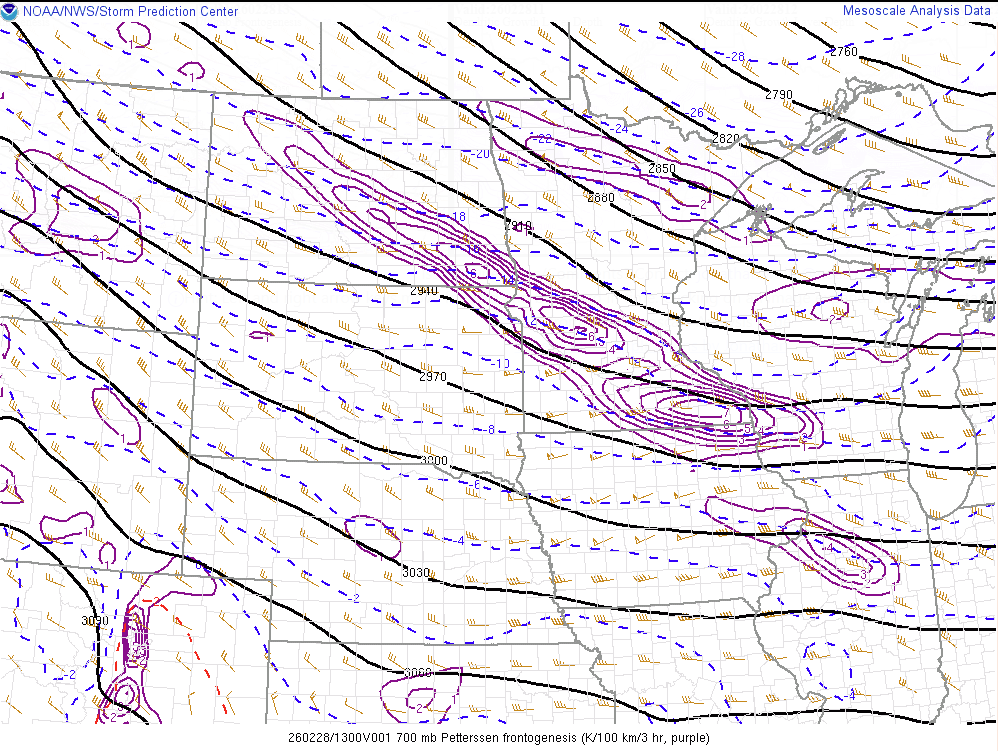
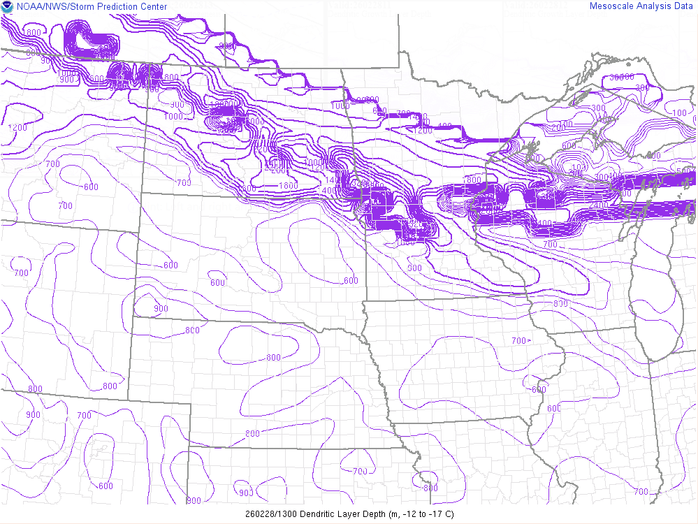
It took the alignment of multiple variables to produce this exceptional event. The driver of this snow was an strong band of mid-level frontogenesis rooted around 700 to 600 mb (10-13,000 ft) above the surface. This lift was maximized within a favored region in the atmosphere called the "dendritic growth zone", a region with temperatures between -12 and -18 C. As the name implies, this is where dendrite snowflakes form, which are the most efficient at producing high snow amounts. Not only was the lift within the DGZ, but the DGZ was deep in nature (over 4,000 ft thick). Moisture content within the DGZ was exceptional, with a deep region of super-saturation (with respect to ice) that allowed ice crystals to grow rapidly. Winds were light under this area of lift, which kept the snowflakes intact as they fell to the surface. Finally, all of these ingredients sat over the same location for 5-6 hours, producing snow rates of 1-2"/hr and rapid snow accumulations.
 |
 |
 |
| The 700-m frontogenesis band (purple lines) maxed out over SE Minnesota at 7am (13Z) 2/28. | The depth of the optimal dendritic growth zone (defined in this plot as between -12 and -17C) at 7am (13Z) 2/28 showing values over 1-km deep extending into SE Minnesota. | A forecast sounding under the snow band showing all of the major ingredients in place. Omega (lift) is shown in the white line--the further to the left the line goes, the stronger the lift. Saturation with respect to ice is shown with the light blue line--anywhere the line is to the right of the red temperature trace, the profile is super saturated. Winds are shown on the right side of the image, with light winds in the lowest 200-300 mb of the profile. |
Event Forecasts
Computer forecasts as early as 5 days out had alluded that a narrow west-to-east band of snow would affect the Upper Midwest, but varied considerably on the intensity and location. The initial Winter Weather Advisory issued on Friday morning focused on the corridor of highest snow potential from far southeast MN into southwest WI. The advisory was expanded northward Friday afternoon as the computer models split into two camps--one track that was mainly north of I-90 and weaker owing to more dry air intrusion and one that was slightly further south and stronger. Knowing that a significant portion of the advisory may see little to no snow owing to this dichotomy of possibilities, the advisory text explicitly mentioned that "snow amounts will sharply decrease on either side of the band" and a "small change in the storm track greatly affects impacts and amounts." As the event horizon narrowed Saturday morning and it was becoming clear that the southern, more intense track would occur, the advisory footprint was adjusted accordingly.
 |
 |
 |
 |
| 48 Hour Forecast (NWS La Crosse) |
36 Hour Forecast (NWS La Crosse) |
24 Hour Forecast (NWS La Crosse) |
18 Hour Forecast (NWS La Crosse) |
Event Messaging
 |
 |
 |
 |
| Feb 28th 10:00 AM (NWS La Crosse) |
Feb 28th 12:00 PM (NWS La Crosse) |
Feb 28th 2:00 PM (NWS La Crosse) |
Afternoon Snowfall Forecast Update (NWS La Crosse) |
 |
Media use of NWS Web News Stories is encouraged! Please acknowledge the NWS as the source of any information accessed from this site. |
|


 Weather Story
 Weather Map
 Local Radar