Easter can occur anywhere from March 22nd to April 25th. The next time that Easter will occur on the earliest date is 2285. Meanwhile, it will not occur on the latest date until 2038. Below are some Easter climate statistics for La Crosse, WI, and Rochester, MN. All referenced temperatures are Fahrenheit.
The following statistics comprise 154 years of data. From 1873 through 1950, the data came from various locations in downtown La Crosse. Since 1950, the data has been gathered at the La Crosse Regional Airport.
| Easter in La Crosse, WI (Period of Record 1873-2026) |
||||
|
1991-2020 Normals
|
Records
|
|||
| Maximum Temperature |
49° to 64°
(March 22 to April 25) |
Warmest High Temperature |
86°
|
April 10, 1977
|
| Coldest High Temperature |
16°
|
March 25, 1894
|
||
| Minimum Temperature |
29° to 42°
(March 22 to April 25) |
Warmest Low Temperature |
63°
|
April 13, 1941
|
| Coldest Low Temperature |
2°
|
March 24, 1940
|
||
| Average Temperature |
39° to 53°
(March 22 to April 25) |
Warmest Average Temperature |
72.0°
|
April 10, 1977
|
| Coldest Average Temperature |
11.0°
|
March 24, 1940
March 25, 1894 |
||
| Precipitation |
0.07" to 0.14"
(March 22 to April 25) |
Wettest |
1.90"
|
April 12, 1903
|
| Snowfall |
0.2" to 0.1"
(March 22 to April 25) |
Snowiest |
8.3"
|
March 31, 1929
|
| Snow Depth at 7 AM |
1" to 0"
(March 22 to April 25) |
Most Snow on the Ground at 7 AM |
6"
|
March 31, 1929
|
The odds of having any precipitation at all on Easter are 45.5% (70 out of 154). There has been measurable (0.01" or greater) precipitation on 52 Easters (33.8%) and trace amounts of precipitation on another 18 Easters (11.7%).
Since 1897, it has snowed on 23 out of 130 (17.7%) Easters. Measurable snow (0.1" or greater) has fallen on 12 Easters (9.2%) and trace amounts fell on another 11 Easters (8.5%). The last time measurable snow fell on Easter was in 2020 (April 12). when 1.5" fell.
Since 1893, residents have woken up with measurable snow (1/2" or greater) on the ground 15 times (11.2%), trace amounts (less than a 1/2") 7 times (5.2%), and no snow 112 times (83.6%). The last time that there was measurable snow on the ground on Easter was in 2008 (March 23rd) when there were 3 inches of snow on the ground at 7 a.m.
In 2027, Easter will be on March 28. Since 1873, Easter has occurred on this date, 4 times (1875, 1880, 1937, and 1948).
| Easters on March 28 in La Crosse, WI | |||||
| Year | High Temperature | Low Temperature | Precipitation | Snowfall | Snow Depth |
| 1875 | 55°F | 35°F | 0.00" | M | M |
| 1880 | 50°F | 36°F | 0.00" | M | M |
| 1937 | 40°F | 21°F | 0.00" | 0.0" | 1" |
| 1948 | 45°F | 25°F | 0.00" | 0.0" | 0" |
Last Easter (April 5, 2026), the high temperature was 57°F and the low temperature was 32°F. A trace of rain fell. The average wind speed was 12.8 mph and there was no snow on the ground at 7 a.m.
The following statistics comprise 114 years of data. From 1887 through 1931, the data came from several cooperative observers in the Rochester area. Since 1932, the data has been gathered at the Rochester International Airport. No data was taken on Easter from 1889 to 1891, 1908, and 1921 to 1928.
| Easter in Rochester, MN (Period of Record 1887-2026) |
||||
|
1991-2020 Normals
|
Records
|
|||
| Maximum Temperature |
43° to 60°
(March 22 to April 25) |
Warmest High Temperature |
85°
|
April 10, 1977
|
| Coldest High Temperature |
15°
|
March 24, 1940
|
||
| Minimum Temperature |
26° to 39°
(March 22 to April 25) |
Warmest Low Temperature |
59°
|
April 13, 1941
|
| Coldest Low Temperature |
1°
|
March 24, 1940
|
||
| Average Temperature |
35° to 49°
(March 22 to April 25) |
Warmest Average Temperature |
69.5°
|
April 13, 1941
|
| Coldest Average Temperature |
8.0°
|
March 24, 1940
|
||
| Precipitation |
0.07" to 0.13"
(March 22 to April 25) |
Wettest |
1.36"
|
April 20, 2025
|
| Snowfall |
0.3" to 0.1"
(March 22 to April 25) |
Snowiest |
9"
|
March 31, 1929
|
| Snow Depth at 7 AM |
2" to 0"
(March 22 to April 25) |
Most Snow on Ground at 7 AM |
18"
|
March 25, 1951
|
The odds of having any precipitation at all on Easter are 45.5% (50 out of 110). There has been measurable (0.01" or greater) precipitation on 40 Easters (36.4%) and trace amounts of precipitation on another 10 Easters (9.1%).
It has snowed on 20 out of 106 (18.9%) Easters. Measurable snow (0.1" or greater) has fallen on 14 Easters (13.2%) and trace amounts of snow fell on another 6 Easters (5.7%).
Residents have woken up with measurable snow (half-inch or greater) on the ground 12 times (14.1%), trace amounts (less than a half-inch) 12 times (14.1%), and no snow 61 times (71.8%).
In 2027, Easter will be on March 28. Since 1886, Easter has occurred on this date, 2 times (1937 and 1948).
| Easters on March 28 in Rochester, MN | |||||
| Year | High Temperature | Low Temperature | Precipitation | Snowfall | Snow Depth |
| 1937 | 30°F | 12°F | 0.00" | 0.0" | 8" |
| 1948 | 47°F | 20°F | T | 0.0" | 0" |
Last Easter (April 5, 2026), the high temperature was 52°F and the low temperature was 29°F. A trace of rain fell. The average wind speed was 15.6 mph and there was no snow on the ground at 7 a.m.
 |
Easter
Weather History
|
|
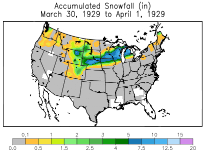
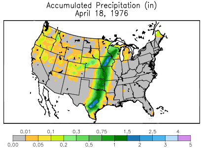
In 1929 (March 31st), snow began falling on the evening of March 30th in Wisconsin and continued to fall through March 31st (Easter) and into the morning of April 1st. Snow amounts ranged from 2 inches in southwest Wisconsin to two feet or more in some northeastern localities. Prior to this storm, the snow had practically disappeared from central and southern counties. This snow was accompanied by high wind, and in the southern and southwestern sections by sleet and glaze. In addition, thunder was reported at La Crosse on Easter. Roads were blocked and traffic was seriously delayed over a wide area. Trees and overhead wire systems suffered severely. The drifting snow isolated small towns for several days. Damage was estimated in the millions of dollars. Some snow totals included: Plymouth (18.0"), Eau Claire (10.5"), La Crosse (10.3"), Madison (7.9"), West Bend (7.0"), Merrill (7.1"), Viroqua (7.0"), and Darlington (6.0"). The image below is courtesy of the Midwestern Regional Climate Center and it shows how much and where the snow fell from March 30 through April 1, 1929. The following weather events affected southeast Minnesota, northeast Iowa, and western Wisconsin on Easter:
 |
 |
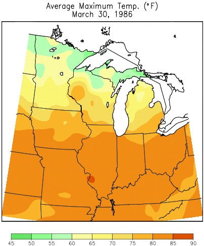
| High Temperatures on March 30, 1986 (Compliments Midwestern Regional Climate Center) |
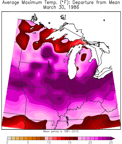
Temperature Departures on March 30, 1986 (Compliments Midwestern Regional Climate Center) |


 Weather Story
 Weather Map
 Local Radar