Overview
|
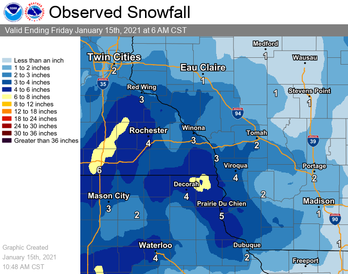
A winter storm brought snow to the region Thursday into Friday after beginning as a wintry mix. Snowfall accumulations were highest (around 6 inches) over portions of southeast Minnesota and northeast Iowa just west and south of La Crosse, Wisconsin - and also closer to Interstate 35. Those accumulations mainly came Thursday night. The snow that did fall was quite heavy with a high liquid water content. |
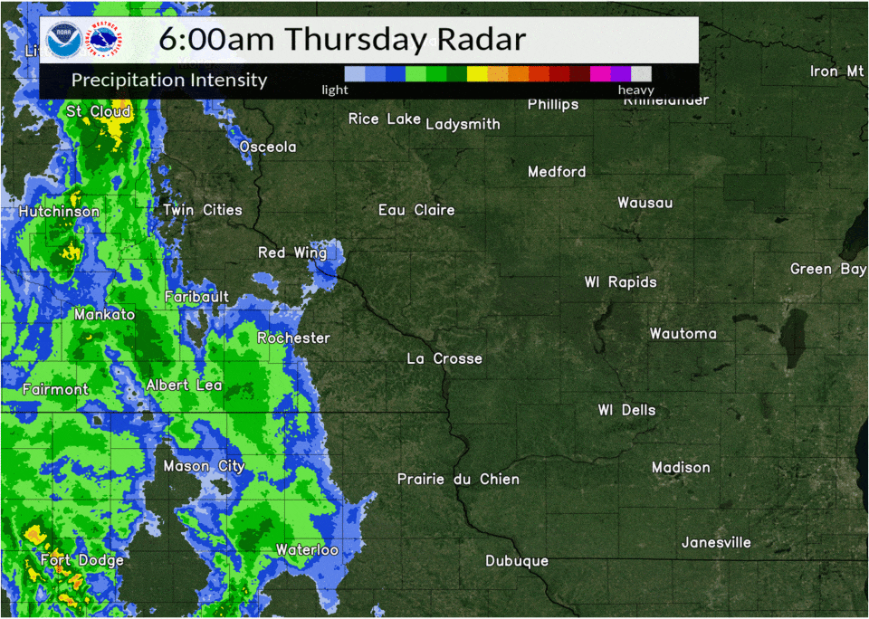 Radar Loop: 6 am Thursday through 10 am Friday |
Snow/Ice
...SNOWFALL REPORTS...

Location                     Amount    Time/Date       Lat/Lon

...Iowa...

...Allamakee County...
Waukon 3N                    6.4 in    0600 AM 01/15   43.31N/91.46W
Waukon                       6.0 in    0615 AM 01/15   43.27N/91.48W
2 ENE Dorchester             5.8 in    0810 AM 01/15   43.48N/91.46W
Postville 5.5 NE             5.1 in    0700 AM 01/15   43.14N/91.49W
Harpers Ferry 6.4 SSW        4.5 in    0700 AM 01/15   43.11N/91.20W

...Chickasaw County...
New Hampton                  4.0 in    0700 AM 01/15   43.06N/92.31W

...Clayton County...
Luana                        5.5 in    0534 AM 01/15   43.06N/91.45W
Guttenberg Dam 10            5.0 in    0800 AM 01/15   42.79N/91.10W
Elkader 6.8 WSW              1.8 in    0601 AM 01/15   42.81N/91.52W
Elkader 6SSW                 1.7 in    0700 AM 01/15   42.78N/91.45W

...Fayette County...
Waucoma 1 WNW                2.0 in    0700 AM 01/15   43.06N/92.05W
Fayette                      2.0 in    0651 AM 01/15   42.88N/91.83W

...Floyd County...
Nora Springs 2.4 SSE         2.7 in    0700 AM 01/15   43.11N/92.99W
Marble Rock                  2.0 in    0715 AM 01/15   42.96N/92.87W
Charles City                 1.7 in    0700 AM 01/15   43.06N/92.67W
4 E Rockford                 1.5 in    1111 PM 01/14   43.05N/92.87W

...Howard County...
Cresco                       3.0 in    0623 AM 01/15   43.37N/92.12W

...Mitchell County...
Osage                        3.7 in    0700 AM 01/15   43.28N/92.81W

...Winneshiek County...
7 ENE Decorah                6.3 in    0811 AM 01/15   43.34N/91.64W
Ossian                       6.0 in    0220 AM 01/15   43.15N/91.76W
3 WNW Decorah                4.3 in    0652 AM 01/15   43.32N/91.86W
Decorah 4.9SE                4.2 in    0700 AM 01/15   43.26N/91.70W
Calmar                       3.3 in    0556 AM 01/15   43.18N/91.86W

...Minnesota...

...Dodge County...
Mantorville 1.9 ESE          6.5 in    0700 AM 01/15   44.05N/92.72W
Hayfield 0.3 SSE             4.8 in    0830 AM 01/15   43.89N/92.85W
1 NNE Kasson                 3.5 in    0753 AM 01/15   44.05N/92.74W
Kasson                       1.5 in    1005 PM 01/14   44.03N/92.75W

...Fillmore County...
Harmony                      5.0 in    0529 AM 01/15   43.55N/92.01W
1 S Peterson                 4.8 in    0725 AM 01/15   43.77N/91.83W
Chatfield                    4.5 in    0820 AM 01/15   43.84N/92.19W
1 NW Carimona                4.0 in    0408 AM 01/15   43.68N/92.17W
2 N Rushford                 4.0 in    0855 PM 01/14   43.84N/91.75W
Wykoff 3.1 NW                3.3 in    0700 AM 01/15   43.74N/92.31W

...Houston County...
Caledonia 5.4 S              6.0 in    0800 AM 01/15   43.56N/91.51W
5 SE Spring Grove            6.0 in    1026 PM 01/14   43.52N/91.57W
Spring Grove                 5.5 in    0755 AM 01/15   43.56N/91.64W
Hokah 4 NW                   3.8 in    0700 AM 01/15   43.80N/91.43W
3 WSW La Crescent            3.0 in    0910 PM 01/14   43.81N/91.36W

...Mower County...
4 WSW Austin                 4.5 in    0633 AM 01/15   43.64N/93.05W
1 SW Austin                  4.0 in    0900 AM 01/15   43.66N/92.98W
Austin 2.4 W                 3.8 in    0633 AM 01/15   43.67N/93.02W

...Olmsted County...
4 WSW Rochester              5.5 in    0807 AM 01/15   43.99N/92.56W
Rochester AP 2NE             4.4 in    0700 AM 01/15   43.93N/92.48W
5 SW Elba                    4.1 in    0820 AM 01/15   44.05N/92.09W
Rochester 5.7 N              4.1 in    0745 AM 01/15   44.10N/92.46W
Rochester 4.7 N              4.1 in    0700 AM 01/15   44.08N/92.48W
1 NW Rochester               4.0 in    0820 AM 01/15   44.02N/92.49W
1 NE Rochester               4.0 in    0730 AM 01/15   44.02N/92.46W
Stewartville                 4.0 in    0639 AM 01/15   43.86N/92.49W
4 ESE Douglas                4.0 in    0600 AM 01/15   44.08N/92.51W
Byron                        4.0 in    1218 AM 01/15   44.03N/92.65W
3 WNW Rochester              3.8 in    0522 AM 01/15   44.04N/92.53W
Elgin 2SSW                   3.7 in    0700 AM 01/15   44.10N/92.27W
2 NE Rochester               2.0 in    0600 AM 01/15   44.04N/92.44W
1 SW Rochester               2.0 in    1115 PM 01/14   44.00N/92.49W
3 N Stewartville             1.0 in    0600 PM 01/14   43.90N/92.49W

...Wabasha County...
Zumbro Falls 3.5 SSW         5.0 in    0700 AM 01/15   44.24N/92.46W
Theilman 1 SSW               4.3 in    0730 AM 01/15   44.28N/92.19W
0.9 N Wabasha                3.6 in    0700 AM 01/15   44.38N/92.05W
0.8 SW Lake City             2.0 in    0700 AM 01/15   44.44N/92.28W

...Winona County...
Winona 1.3 SSW               4.5 in    0730 AM 01/15   44.03N/91.68W
Minnesota City               4.4 in    0632 AM 01/15   44.09N/91.75W
Lewiston                     4.0 in    0740 AM 01/15   43.98N/91.87W
3 S Winona                   3.7 in    0600 AM 01/15   44.00N/91.66W
Winona Dam 5A                3.5 in    0800 AM 01/15   44.09N/91.67W
1 W Stockton                 3.5 in    0539 AM 01/15   44.03N/91.79W
La Crescent Dam 7            3.0 in    0800 AM 01/15   43.87N/91.31W
Winona                       2.8 in    1213 AM 01/15   44.05N/91.66W
4.2 N Rollingstone           2.7 in    0800 AM 01/15   44.16N/91.81W

...Wisconsin...

...Adams County...
Oxford 4.0 W                 2.0 in    0700 AM 01/15   43.79N/89.64W
0.6 W Friendship             1.4 in    0700 AM 01/15   43.98N/89.83W

...Buffalo County...
Waumandee                    3.6 in    0841 AM 01/15   44.30N/91.71W
Cochrane                     2.3 in    0815 AM 01/15   44.22N/91.84W
Alma Dam 4                   2.0 in    0800 AM 01/15   44.33N/91.92W

...Clark County...
Neillsville                  1.0 in    0714 AM 01/15   44.56N/90.59W

...Crawford County...
3 NE Eastman                 5.1 in    0610 AM 01/15   43.19N/90.98W
Eastman                      4.5 in    0730 AM 01/15   43.16N/91.02W
Steuben 4SE                  4.2 in    0730 AM 01/15   43.13N/90.84W
Prairie Du Chien 1.4 N       4.1 in    0700 AM 01/15   43.06N/91.14W
2 SE Prairie Du Chien        4.0 in    0619 AM 01/15   43.02N/91.11W
1 S De Soto                  4.0 in    0534 AM 01/15   43.41N/91.19W
Prairie Du Chien             4.0 in    0820 PM 01/14   43.04N/91.14W
Gays Mills 1.0 NE            3.2 in    0700 AM 01/15   43.33N/90.84W

...Grant County...
Cassville 7.8 ENE            5.5 in    0700 AM 01/15   42.75N/90.84W
Mount Hope                   4.5 in    0523 AM 01/15   42.97N/90.86W
4.3 W Lancaster              3.9 in    0800 AM 01/15   42.83N/90.79W
Muscoda                      2.5 in    0617 AM 01/15   43.19N/90.43W
1 W Platteville              2.0 in    1000 PM 01/14   42.74N/90.49W

...Jackson County...
Melrose                      2.5 in    0740 AM 01/15   44.13N/91.00W
4 E Northfield               1.8 in    0852 AM 01/15   44.45N/91.01W
Black River Falls 1.7 NNE    1.7 in    0700 AM 01/15   44.32N/90.83W

...Juneau County...
1.0 E Mauston                3.0 in    0800 AM 01/15   43.79N/90.06W
Lyndon Station               2.0 in    0455 AM 01/15   43.71N/89.90W

...La Crosse County...
Holmen                       4.0 in    0505 AM 01/15   43.96N/91.26W
La Crosse 4NNW               3.5 in    0730 AM 01/15   43.87N/91.27W
5 SSE La Crosse              3.0 in    0230 AM 01/15   43.75N/91.19W
Coon Valley 4.5 NNW          2.7 in    0700 AM 01/15   43.76N/91.06W
4 NE New Amsterdam           2.5 in    0500 AM 01/15   44.03N/91.27W
Onalaska                     2.0 in    0905 AM 01/15   43.89N/91.22W
1 N Holmen                   2.0 in    0622 AM 01/15   43.98N/91.26W
2 E La Crosse                2.0 in    0845 PM 01/14   43.82N/91.19W
1 WSW West Salem             1.7 in    1135 PM 01/14   43.90N/91.10W
2 SSE Holmen                 1.0 in    0905 PM 01/14   43.93N/91.24W

...Monroe County...
3 NNE Tunnel City            3.0 in    0825 AM 01/15   44.04N/90.55W
Cashton 3 NNW                2.7 in    0744 AM 01/15   43.79N/90.80W
Tomah                        2.7 in    0741 AM 01/15   43.99N/90.50W
1 N Tomah                    2.6 in    0800 AM 01/15   44.01N/90.50W
0.5 SW Sparta                2.0 in    0800 AM 01/15   43.94N/90.82W

...Richland County...
Richland Center 4.0 N        1.0 in    0800 AM 01/15   43.40N/90.39W
5 ESE Ithaca                 1.0 in    0445 AM 01/15   43.31N/90.19W

...Taylor County...
Lublin                       3.0 in    0657 AM 01/15   45.08N/90.72W
0.6 SE Medford               0.6 in    0800 AM 01/15   45.13N/90.34W
Medford 0.8 ENE              0.6 in    0700 AM 01/15   45.14N/90.33W

...Trempealeau County...
Galesville 4.7 E             2.5 in    0700 AM 01/15   44.08N/91.26W
3 SSW Whitehall              2.5 in    0442 AM 01/15   44.33N/91.34W
Trempealeau Dam 6            2.0 in    0800 AM 01/15   44.00N/91.44W
Ettrick 4.0 WNW              2.0 in    0724 AM 01/15   44.19N/91.34W
Galesville                   2.0 in    0611 AM 01/15   44.08N/91.36W
Galesville 2WSW              1.9 in    0700 AM 01/15   44.07N/91.39W

...Vernon County...
3 N Victory                  4.0 in    0750 AM 01/15   43.53N/91.22W
Genoa Dam 8                  3.5 in    0800 AM 01/15   43.57N/91.23W
Viroqua 0.8 ESE              3.5 in    0700 AM 01/15   43.55N/90.87W
Stoddard 4.7 NNE             3.5 in    0700 AM 01/15   43.72N/91.17W
Hillsboro 0.5 WSW            2.8 in    0700 AM 01/15   43.65N/90.35W
Hillsboro 2 SW               2.6 in    0700 AM 01/15   43.63N/90.38W
2 NE Stoddard                2.2 in    0634 AM 01/15   43.68N/91.19W
Readstown                    2.0 in    0810 AM 01/15   43.45N/90.76W
La Farge                     2.0 in    0930 PM 01/14   43.58N/90.64W
Radar:
|
|||
| 6 am Thursday to 10 am Friday |
 |
Media use of NWS Web News Stories is encouraged! Please acknowledge the NWS as the source of any news information accessed from this site. |
|


 Weather Story
 Weather Map
 Local Radar