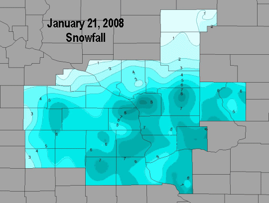
An area of low pressure formed in the lee of the Rocky mountains during the night of January 20th. The low quickly moved from Kansas to lower Michigan during the day and night of the 21st. As the low progressed northeast, an upper level disturbance tracked east across the Upper Midwest. These two systems combined to produce a prolonged period of snow across the region. Snow formed over Nebraska, South Dakota and Iowa early in the morning of the 21st and by daybreak it had spread into northeast Iowa and southeast Minnesota. The snow continued to spread east and by late morning had reached into central Wisconsin. The snow continued into the night before ending around midnight on the 22nd for most locations. At times, heavy snow occurred during the afternoon and early evening with snow rates of two and a half inches an hour for short periods of time. Even though some heavy snow did occur, the snow was very light in weight. Normally, snow to water ratios are around 12 to 1, but at the National Weather Service office, the ratio was 36 to 1 and during the afternoon reached an incredible 47 to 1!
A more typical snow ratio for the Upper Midwest is 12:1...meaning, for every inch of liquid water, there would be 12 inches of snow. However, there are many factors that go into the snow ratio, and how much falls can vary not only from event to event, but within the event themselves! In the case of this snowfall, the very cold air entrenched across the region was the main factor for producing ratios upwards of 30:1. In addition, lighter winds allowed these large, very fluffy, and quick accumulating snowflakes to reach the ground intact. This further enabled the snow's ability to accumulate with a very low amount of water.
Initially, the snow started to fall as small ice crystals, leading to relatively minor accumulations, with ratios closer to 10:1. By the afternoon though, atmospheric conditions had changed to support larger snowflakes, with the cold and light winds being supporting factors. Snowfall rates of an inch per hour became common, with snow ratios now in that 30:1 range.
PUBLIC INFORMATION STATEMENT
NATIONAL WEATHER SERVICE LA CROSSE WI
1108 AM CST TUE JAN 22 2008
...STORM TOTAL SNOWFALL AMOUNTS FOR JANUARY 21ST-22ND...
LOCATION COUNTY SNOWFALL
...NORTHEAST IOWA...
WAUKON ALLAMAKEE 7.8
FAYETTE FAYETTE 7.2
EDGEWOOD CLAYTON 6.5
ELKADER 6SSW CLAYTON 6.5
DECORAH WINNESHIEK 6.5
WAUKON 8NW ALLAMAKEE 6.3
CALMAR WINNESHIEK 6.2
VOLGA 1NE ALLAMAKEE 6.1
ELKADER CLAYTON 6.0
MCINTIRE 3E HOWARD 6.0
DECORAH 8NE WINNESHIEK 6.0
DECORAH 5E WINNESHIEK 5.5
CRESCO HOWARD 5.5
ELMA HOWARD 5.3
STRAWBERRY POINT CLAYTON 5.2
CHARLES CITY COOP FLOYD 5.0
NEW HAMPTON CHICKASAW 5.0
OSAGE MITCHELL 4.6
ST ANSGAR MITCHELL 4.5
DORCHESTER ALLAMAKEE 4.4
DECORAH 8NE WINNESHIEK 6.0
...SOUTHEAST MINNESOTA...
LA CRESCENT 1NNW HOUSTON 8.2
HOUSTON 5E HOUSTON 8.0
LA CRESCENT 2N HOUSTON 7.5
STEWARTVILLE OLMSTED 6.8
GRAND MEADOW MOWER 6.5
SPRING VALLEY 3SW FILLMORE 6.0
ROCHESTER INTL AP OLMSTED 5.6
PRESTON FILLMORE 5.3
LANESBORO FILLMORE 5.0
SPRING GROVE 4N HOUSTON 5.0
WINONA DAM 5A WINONA 5.0
GOODVIEW WINONA 4.6
SPRING VALLEY FILLMORE 4.0
ALTURA 5W WINONA 4.0
ELGIN 2SSW OLMSTED 2.7
THEILMAN 1SSW WABASHA 2.6
AUSTIN WWTF MOWER 2.5
WABASHA WABASHA 1.7
...SOUTHWEST AND CENTRAL WISCONSIN...
WEST SALEM 1NW LA CROSSE 8.8
TUNNEL CITY 1S MONROE 8.6
CUBA CITY GRANT 8.5
LA CROSSE AIRPORT LA CROSSE 8.5
LA CROSSE 4NNW LA CROSSE 8.4
HOLMEN 2S LA CROSSE 8.2
RICHLAND CENTER RICHLAND 8.0
WARRENS 5WSW MONROE 7.8
LA CROSSE WFO LA CROSSE 7.5
DE SOTO 1 SE VERNON 7.5
KIELER GRANT 7.3
LA FARGE VERNON 7.2
LA CROSSE 4SE LA CROSSE 7.2
TOMAH MONROE 7.0
HOLMEN 2NW LA CROSSE 7.0
SINSINAWA GRANT 7.0
STODDARD 3NE VERNON 6.9
MUSCODA 6S GRANT 6.8
LANCASTER 4WSW GRANT 6.7
ONTARIO VERNON 6.5
PLATTEVILLE GRANT 6.5
FRIENDSHIP 10NE ADAMS 6.5
GAYS MILLS CRAWFORD 6.3
NEW LISBON 2N JUNEAU 6.3
ARKDALE ADAMS 6.2
NECEDAH 2SE JUNEAU 5.9
WESTBY 3ENE VERNON 5.9
SPARTA MONROE 5.8
HILLSBORO VERNON 5.7
VIROQUA VERNON 5.6
MONROE CENTER ADAMS 5.5
PRAIRIE DU CHIEN CRAWFORD 5.2
MATHER 3NW JACKSON 5.0
CASSVILLE 8NE GRANT 5.0
FRIENDSHIP ADAMS 4.8
READSTOWN VERNON 4.8
STEUBEN 4SE CRAWFORD 4.8
WHITEHALL 2W TREMPEALEAU 4.0
TAYLOR JACKSON 4.0
BLAIR TREMPEALEAU 2.6
GOODRICH 1E TAYLOR 2.0
MONDOVI 6S BUFFALO 2.0
NEILLSVILLE 3SW CLARK 2.0
OSSEO TREMPEALEAU 1.9
OWEN 2N CLARK 1.1
WESTBORO 4E TAYLOR 1.0
MEDFORD 4NW TAYLOR 1.0
OBSERVATIONS ARE COLLECTED FROM A VARIETY OF SOURCES WITH VARYING
EQUIPMENT AND EXPOSURE. NOT ALL DATA LISTED IS CONSIDERED OFFICIAL.
$$


 Weather Story
 Weather Map
 Local Radar