Overview
|
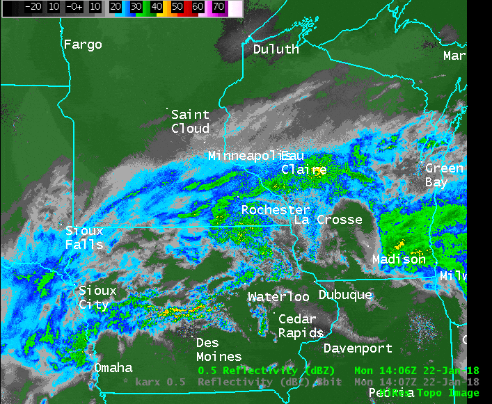 January 22-23, 2018 Radar Loop |
||||
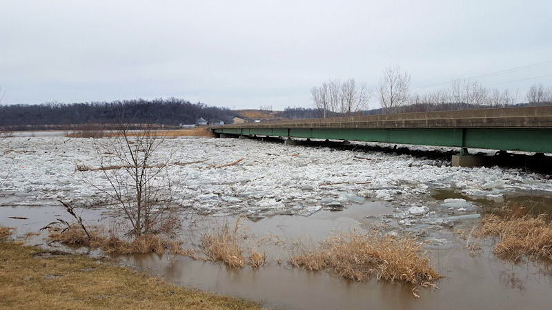
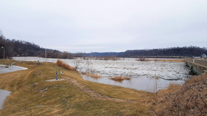
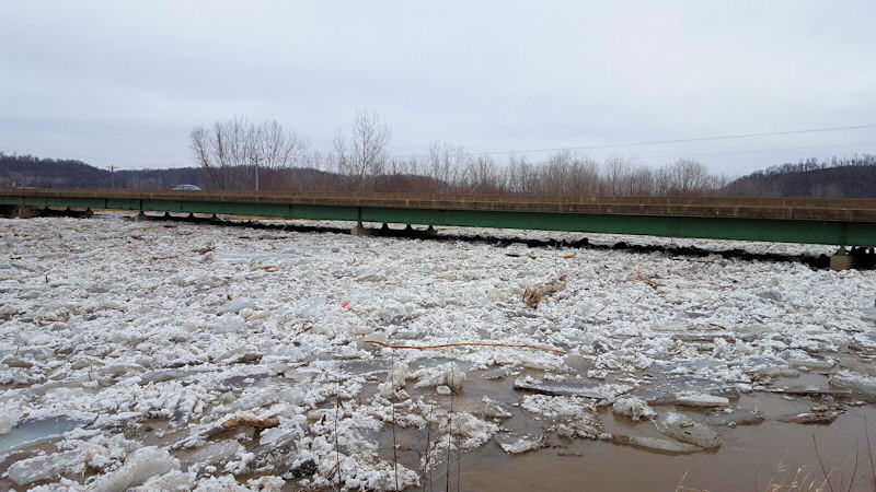
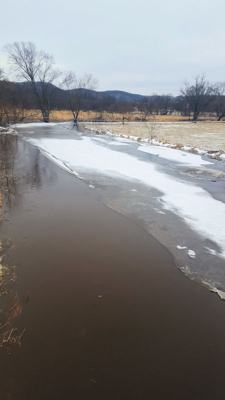
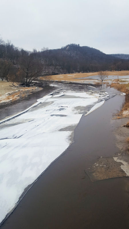
Flooding
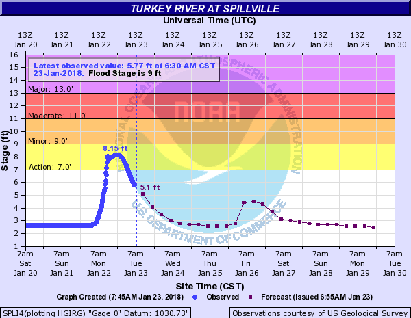
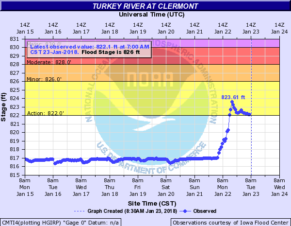
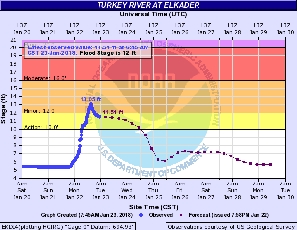
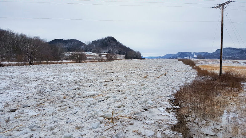
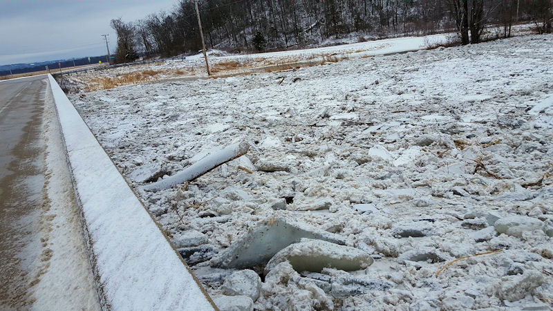
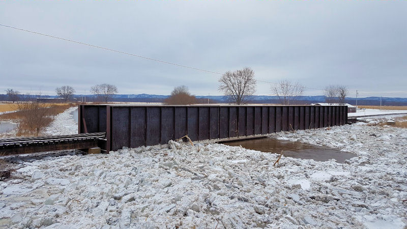
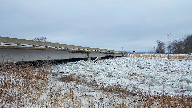
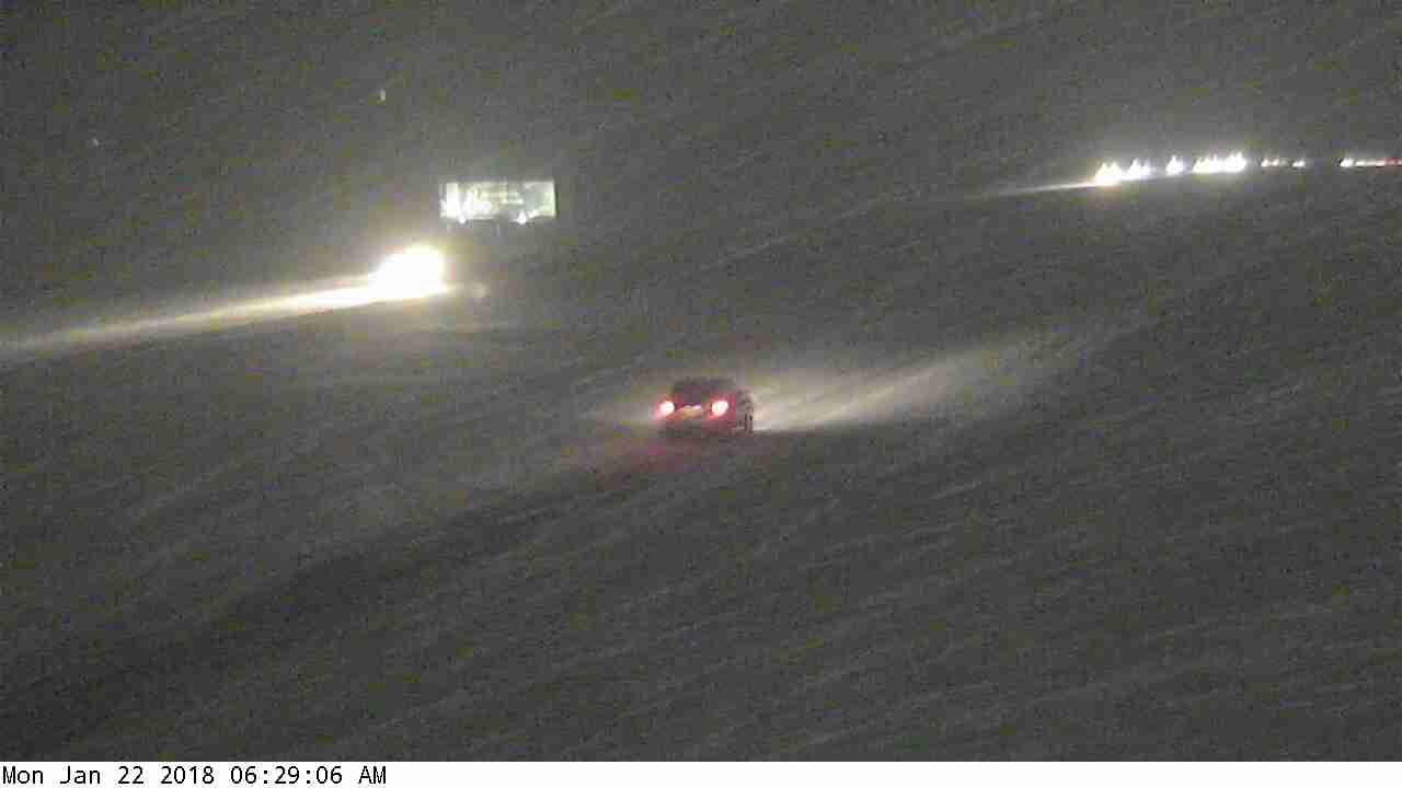
Warm air led to rainfall over much of the region before it switched over to snow. Amounts from 0.50" to 1.50" were common, and with frozen grounds and iced up rivers, runoff resulted in rises on rivers and streams - and ultimately - ice jams and flooding on some of those water ways.
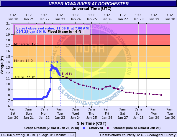
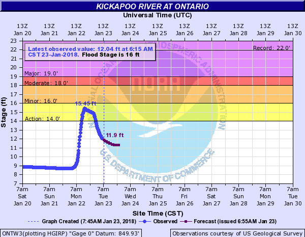
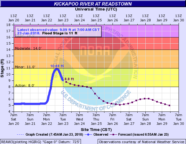
Hydrographs
 |
 |
 |
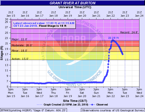 |
| Upper Iowa River at Dorchester, IA | Kickapoo River at Ontario, WI | Kickapoo River at Readstown, WI | Grant River at Burton, WI |
 |
 |
 |
|
| Turkey River at Spillville, IA | Turkey River at Clermont, IA | Turkey River at Elkader, IA |
Photos
Co. Emerg. Mgr)Co. Emerg. Mgr)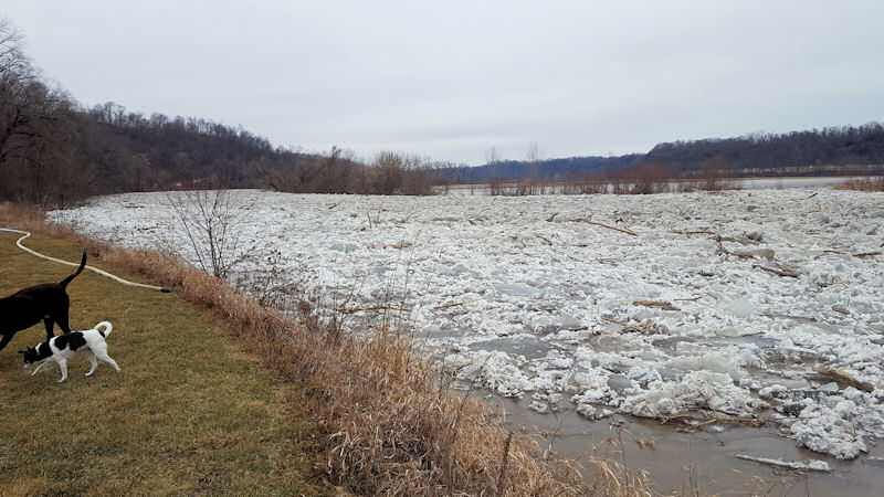 |
 |
 |
 |
| Ice jam along Turkey River near Millville, IA. (Photo taken by Kelly Fairbanks) | Ice jam along Turkey River near Millville, IA. (Photo taken by Kelly Fairbanks) | Ice jam along Turkey River near Millville, IA. (Photo taken by Kelly Fairbanks) | Ice jam along Turkey River near Millville, IA. (Photo taken by Kelly Fairbanks) |
 |
 |
 |
 |
| Ice jam along Upper Iowa River near New Albin, IA. (Photo taken by Allamakee Co. Emerg. Mgr) | Ice jam along Upper Iowa River near New Albin, IA. (Photo taken by Allamakee Co. Emerg. Mgr) | Ice jam along Upper Iowa River near New Albin, IA. (Photo taken by Allamakee Co. Emerg. Mgr) | Ice jam along Upper Iowa River near New Albin, IA. (Photo taken by Allamakee Co. Emerg. Mgr) |
 |
 |
||
| Kickapoo River near La Farge, WI. (Photo taken by Vernon Co. Emerg. Mgr) | Kickapoo River near La Farge, WI. (Photo taken by Vernon Co. Emerg. Mgr) |
Snow Reports
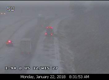
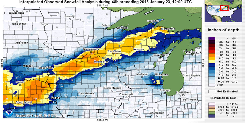
...Snowfall Totals From January 22 2018...

Location                     Amount

...IOWA...

...Chickasaw County...
New Hampton                   1.0 in

...Fayette County...
Waucoma 1WNW                  1.0 in

...Floyd County...
Charles City                  1.6 in
Nashua 2SW                    0.5 in

...Howard County...
Cresco                        1.0 in
Elma                          0.4 in

...Mitchell County...
St Ansgar                     2.2 in
Osage                         1.8 in

...Winneshiek County...
Calmar NE                     0.4 in
Decorah 7ENE                  0.3 in

...MINNESOTA...

...Dodge County...
West Concord                 14.0 in
Kasson                       13.5 in
Kasson 2NE                   11.5 in

...Fillmore County...
Fillmore 1W                   2.3 in
Lanesboro 2NE                 2.0 in
Pilot Mound 1SSE              1.8 in
Preston                       1.0 in
Spring Valley                 0.5 in
Mabel                         0.4 in

...Houston County...
La Crescent 1NNW              1.5 in
Eitzen 4NW                    1.4 in
Caledonia                     1.0 in

...Mower County...
Austin WWTP                   6.4 in
Austin                        5.5 in
Grand Meadow                  4.5 in

...Olmsted County...
Byron                        12.0 in
Pine Island 1S               11.5 in
3 NNW Rochester              10.5 in
Oronoco                      10.0 in
Rochester NW                  9.5 in
Rochester - KTTC              9.3 in
Rochester NE                  8.5 in
Rochester Intl Airport        8.1 in
Byron 4N                      8.0 in
Elgin 2SSW                    7.0 in
Stewartville                  6.8 in
Rochester 1SSW                5.8 in
Elba 4.7 SW                   3.5 in

...Wabasha County...
3 NW Wabasha                 10.0 in
5 NNE Zumbro Falls            9.0 in
Plainview N                   9.0 in
1 NE Wabasha                  7.5 in
Theilman 1SSW                 6.9 in
Lake City                     5.0 in
Wabasha                       4.8 in
Wabasha 1N                    4.5 in
Zumbro Falls 3SW              3.8 in

...Winona County...
Winona 4SW                    5.0 in
Minnesota City                4.0 in
Winona 2SW                    3.0 in
Winona Dam 5A                 3.0 in

...WISCONSIN...

...Adams County...
Friendship                    0.5 in

...Buffalo County...
Gilmanton                     8.8 in
Mondovi                       4.3 in
Alma Dam 4                    2.2 in

...Clark County...
Owen 6SSE                     7.5 in
Colby 6SW                     6.0 in
7 SE Riplinger                3.0 in

...Crawford County...
De Soto 1SE                   0.5 in
Mt Zion 1WNW                  0.3 in

...Grant County...
Sinsinawa                     0.3 in
Cuba City                     0.1 in

...Jackson County...
Hixton                        4.0 in
Hatfield Dam                  3.5 in
Hatfield                      3.8 in
Black River Falls             1.5 in

...La Crosse County...
Holmen 2S                     2.4 in
NWS La Crosse                 2.2 in
La Crosse Regional Airport    1.7 in
Holmen 1N                     1.5 in
West Salem                    1.4 in

...Monroe County...
Warrens                       3.0 in
Warrens 5WSW                  1.9 in
Warrens 4WSW                  1.9 in
Cashton                       1.7 in
Four Corners                  1.6 in
Sparta                        1.2 in

...Taylor County...
Medford                      12.0 in
Westboro 4E                  10.0 in
Lublin                        9.5 in
Stetsonville                  8.8 in

...Trempealeau County...
Osseo                         8.0 in
Arcadia                       6.0 in
Whitehall 2W                  6.0 in
Ettrick 4WNW                  4.5 in
Galesville                    2.0 in
Trempealeau Dam 6             1.0 in

...Vernon County...
Westby 3ENE                   2.1 in
Genoa Dam 8                   1.0 in
Stoddard                      0.6 in
Hillsboro                     0.5 in

Observations are collected from a variety of sources with varying
equipment and exposures. We thank all volunteer weather observers
for their dedication. Not all data listed are considered official.

$$
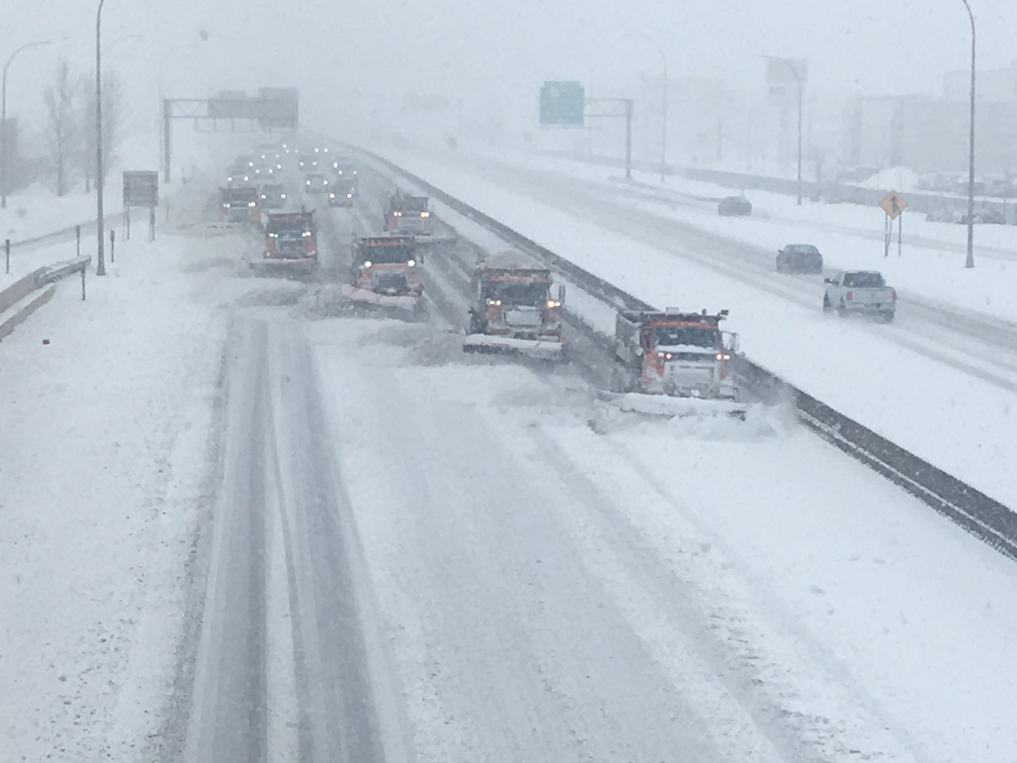
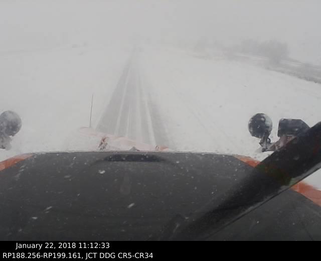
Photos
 |
 |
 |
 |
| Snow plows along Highway 52 in Rochester. (Courtesy of MnDOT) | Snow plow cam from Dodge Co., MN during peak of snowfall. (Courtesy of MnDOT) | Heavy snow falling along Highway 14 west of Rochester, MN. (Courtesy of MnDOT) | Snowfall along I-94 in Jackson Co., WI. (Courtesy of WisDOT) |
 |
|||
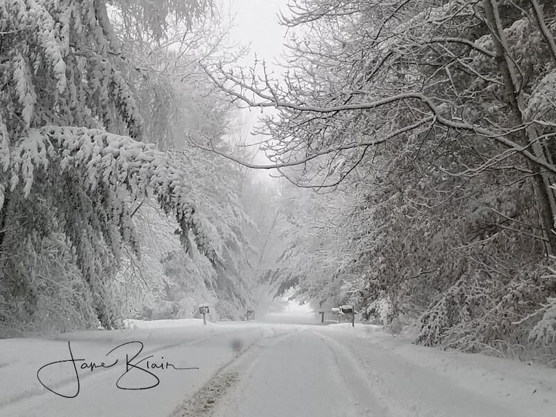
| The beauty of snow in western Wisconsin. (Photo by Jane Blair) |
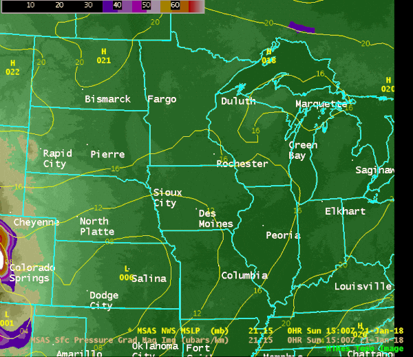
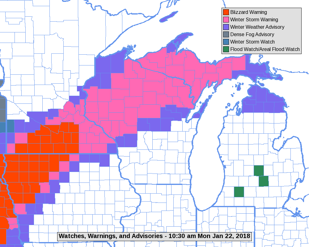
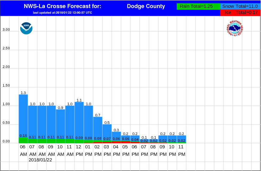
Radar & Environment:
 |
 |
 |
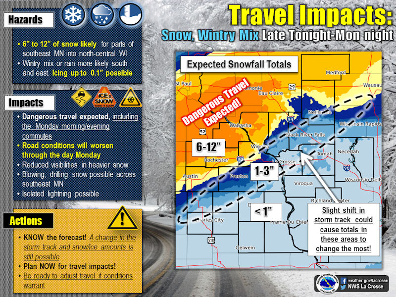 |
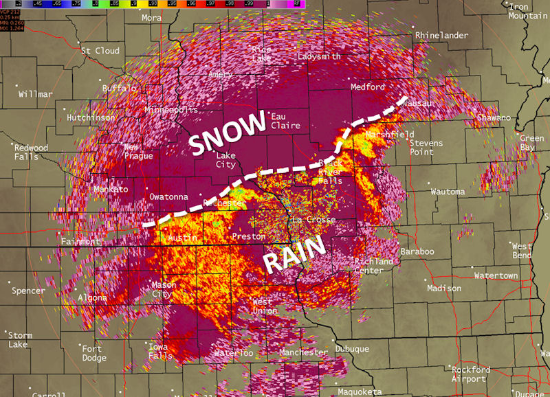
| Correlation Coefficient (CC) image from the dual-pol component of our radar showing the rain-snow line well. (Snow is the pink/purple colors, while the rain was highlighted more by the yellow/red colors) | Map showing the storm system passing through the region. Shaded color areas depict the strongest winds that led to blizzard conditions for parts of Iowa and Minnesota. | Map showing warnings and advisories that were in effect for January 22nd. | Weather story graphic issued by NWS La Crosse showing expected hazards and impacts. |
 |
 |
||
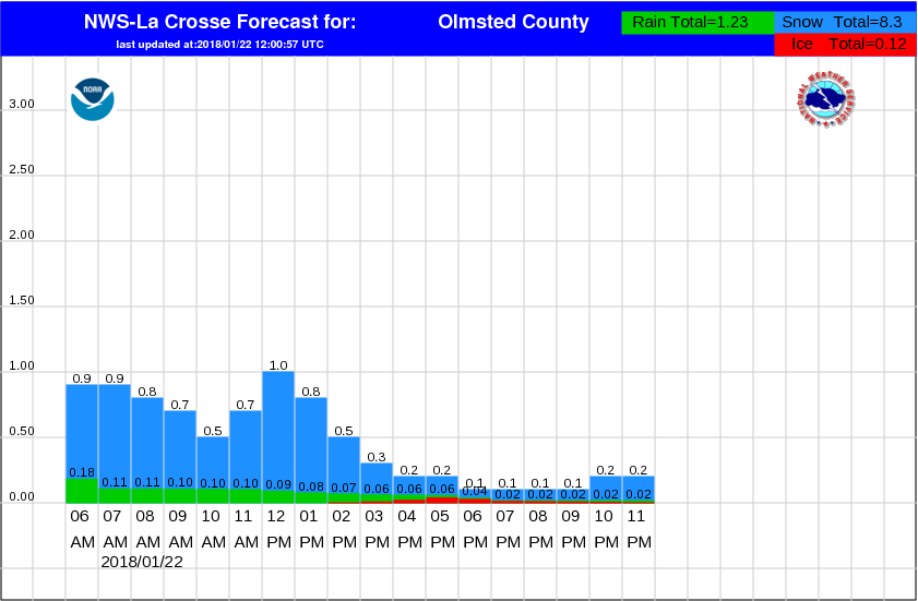
| Hourly snowfall forecasts issued for Dodge Co., MN on Jan.22nd | Hourly snowfall forecasts issued for Olmsted Co., MN on Jan.22nd |
1-Day / 2-Day Rain Reports
Public Information Statement
National Weather Service La Crosse WI
953 AM CST Mon Jan 22 2018

...Rainfall Reports...

Location                     Amount    Time/Date       Lat/Lon

...Iowa...

...Allamakee County...
3 S Dorchester               0.65 in   0900 AM 01/22   43.42N/91.51W
4 ENE Watson                 0.54 in   0845 AM 01/22   43.11N/91.26W

...Chickasaw County...
New Hampton                  1.79 in   0600 PM 01/22   43.06N/92.32W
Fredericksburg               1.46 in   0757 AM 01/22   42.97N/92.20W
Ionia 2W                     1.29 in   0845 AM 01/22   43.03N/92.50W

...Clayton County...
Mcgregor                     1.32 in   0929 AM 01/22   43.02N/91.19W
Monona WWTP                  0.61 in   0700 AM 01/22   43.04N/91.40W
Garber                       0.59 in   0915 AM 01/22   42.74N/91.26W
Littleport                   0.54 in   0845 AM 01/22   42.75N/91.37W
Monona                       0.52 in   0929 AM 01/22   43.04N/91.39W
Strawberry Point             0.45 in   0700 AM 01/22   42.69N/91.53W
Elkader 6SSW                 0.44 in   0700 AM 01/22   42.78N/91.45W
Volga 1NE                    0.44 in   0600 AM 01/22   42.81N/91.52W
Marquette-Bloody Run Creek   0.36 in   0900 AM 01/22   43.04N/91.21W
Guttenberg Dam 10            0.21 in   0600 AM 01/22   42.78N/91.10W

...Fayette County...
1 ENE Alpha                  1.32 in   0722 AM 01/22   43.01N/92.03W
Waucoma 1WNW                 1.20 in   0700 AM 01/22   43.06N/92.05W
Eldorado                     0.85 in   0845 AM 01/22   43.05N/91.81W
Fayette-CWOP                 0.68 in   0933 AM 01/22   42.84N/91.80W
Fayette                      0.51 in   0700 AM 01/22   42.85N/91.82W
4 SSE Arlington              0.48 in   0929 AM 01/22   42.69N/91.65W
Oelwein Municipal Airport    0.44 in   0555 AM 01/22   42.68N/91.97W

...Floyd County...
Nashua 2SW                   1.16 in   0900 AM 01/22   42.93N/92.56W
Nashua 2SW                   1.04 in   0700 AM 01/22   42.94N/92.57W
Charles City                 0.92 in   0700 AM 01/22   43.06N/92.67W
Charles City-Cedar River     0.88 in   0930 AM 01/22   43.06N/92.67W
Charles City Airport         0.70 in   0555 AM 01/22   43.07N/92.61W

...Howard County...
3 NE Riceville               1.18 in   0928 AM 01/22   43.40N/92.50W
Elma                         0.90 in   0700 AM 01/22   43.24N/92.44W
Cresco 1NE                   0.66 in   0700 AM 01/22   43.39N/92.09W

...Mitchell County...
Osage                        0.93 in   0700 AM 01/22   43.28N/92.81W
Saint Ansgar                 0.75 in   0915 AM 01/22   43.38N/92.92W
St Ansgar                    0.52 in   0630 AM 01/22   43.38N/92.92W

...Winneshiek County...
Calmar NE                    0.95 in   0700 AM 01/22   43.19N/91.86W
Bluffton                     0.76 in   0845 AM 01/22   43.41N/91.90W
7 ENE Decorah                0.75 in   0900 AM 01/22   43.34N/91.64W
5 ESE Decorah                0.71 in   0700 AM 01/22   43.26N/91.70W
1 ENE Jackson Junction       0.68 in   0930 AM 01/22   43.11N/92.04W
Decorah                      0.60 in   0929 AM 01/22   43.30N/91.79W
Decorah Municipal Airport    0.45 in   0555 AM 01/22   43.28N/91.74W

...Minnesota...

...Fillmore County...
Lanesboro-Root River         0.79 in   0930 AM 01/22   43.72N/91.98W
Fillmore                     0.65 in   0930 AM 01/22   43.76N/92.27W
Mabel                        0.54 in   0650 AM 01/22   43.52N/91.76W
Spring Valley                0.51 in   0730 AM 01/22   43.69N/92.39W
Pilot Mound-Root River       0.47 in   0900 AM 01/22   43.78N/92.03W
1 W Fillmore                 0.43 in   0700 AM 01/22   43.74N/92.31W

...Houston County...
4 NW Eitzen                  0.67 in   0800 AM 01/22   43.56N/91.51W
Caledonia                    0.61 in   0700 AM 01/22   43.63N/91.50W
La Crescent                  0.60 in   0730 AM 01/22   43.84N/91.31W
1 NNW La Crescent            0.59 in   0800 AM 01/22   43.83N/91.31W
Houston                      0.50 in   0845 AM 01/22   43.77N/91.57W
Mound Prairie                0.41 in   0845 AM 01/22   43.78N/91.45W

...Mower County...
Austin 3 NW - Turtle Creek   0.64 in   0930 AM 01/22   43.65N/92.98W
4 WSW Austin                 0.57 in   0746 AM 01/22   43.64N/93.05W
1 ENE Austin                 0.55 in   0800 AM 01/22   43.68N/92.94W
Austin 2NE-Dobbins Creek     0.54 in   0930 AM 01/22   43.67N/92.95W

...Olmsted County...
2 NE Rochester               0.28 in   0938 AM 01/22   44.04N/92.44W
Byron 4 North                0.28 in   0700 AM 01/22   44.09N/92.64W
4 ESE Douglas                0.27 in   0700 AM 01/22   44.08N/92.48W
2 NNW Rochester              0.23 in   0700 AM 01/22   44.05N/92.49W
Rochester International Airp 0.22 in   0554 AM 01/22   43.91N/92.50W
Dover                        0.21 in   0900 AM 01/22   43.97N/92.12W

...Wabasha County...
3 NW Buffalo                 0.36 in   0929 AM 01/22   44.26N/91.91W

...Winona County...
Great River Bluffs S.P.      0.55 in   0930 AM 01/22   43.94N/91.41W
Dakota                       0.50 in   0915 AM 01/22   43.91N/91.36W
1 WSW Winona                 0.32 in   0650 AM 01/22   44.03N/91.68W
La Crescent Dam 7            0.22 in   0600 AM 01/22   43.87N/91.31W

...Wisconsin...

...Adams County...
Friendship                   0.56 in   0911 AM 01/22   43.97N/89.82W
2 SE New Rome                0.35 in   0700 AM 01/22   44.21N/89.85W
Castle Rock                  0.33 in   0700 AM 01/22   43.87N/89.95W
Friendship                   0.31 in   0700 AM 01/22   43.98N/89.83W
1 SSW Grand Marsh            0.26 in   0700 AM 01/22   43.86N/89.72W

...Crawford County...
De Soto 1SE                  0.78 in   0700 AM 01/22   43.42N/91.19W
De Soto                      0.63 in   0936 AM 01/22   43.42N/91.19W
Steuben                      0.52 in   0845 AM 01/22   43.18N/90.86W
Prairie Du Chien  Airport    0.47 in   0555 AM 01/22   43.02N/91.12W
1 SW Mount Sterling          0.46 in   0906 AM 01/22   43.31N/90.94W
Prairie Du Chien             0.46 in   0700 AM 01/22   43.05N/91.13W
Steuben 4SE                  0.40 in   0700 AM 01/22   43.13N/90.84W

...Grant County...
Cuba City                    0.89 in   0800 AM 01/22   42.60N/90.43W
Cuba City                    0.68 in   0600 AM 01/22   42.61N/90.43W
1 ENE Boscobel               0.53 in   0903 AM 01/22   43.15N/90.68W
Fennimore                    0.52 in   0930 AM 01/22   42.98N/90.66W
Lancaster 4wsw               0.47 in   0800 AM 01/22   42.83N/90.79W
Platteville                  0.41 in   0700 AM 01/22   42.74N/90.47W
Platteville Municipal Airpor 0.33 in   0555 AM 01/22   42.69N/90.44W
Boscobel Airport             0.28 in   0553 AM 01/22   43.16N/90.67W

...Jackson County...
1 E Black River Falls        0.29 in   0915 AM 01/22   44.30N/90.83W

...Juneau County...
Mauston 1se                  0.61 in   0800 AM 01/22   43.79N/90.06W
Mauston                      0.59 in   0937 AM 01/22   43.80N/90.07W
Necedah                      0.52 in   0848 AM 01/22   44.03N/90.08W
2 N Cloverdale               0.45 in   0910 AM 01/22   44.06N/90.17W

...La Crosse County...
1 SW West Salem              0.44 in   0700 AM 01/22   43.88N/91.10W
West Salem                   0.35 in   0700 AM 01/22   43.90N/91.09W
La Crosse 4NNW               0.34 in   0730 AM 01/22   43.87N/91.27W
La Crosse Weather Office     0.29 in   0600 AM 01/22   43.82N/91.19W

...Monroe County...
Cashton 3NNW                 0.53 in   0752 AM 01/22   43.79N/90.80W
Sparta                       0.49 in   0800 AM 01/22   43.94N/90.82W
3 WNW Kendall                0.43 in   0700 AM 01/22   43.81N/90.44W
2 E Cataract                 0.37 in   0938 AM 01/22   44.09N/90.79W
Warrens 4WSW                 0.29 in   0700 AM 01/22   44.10N/90.59W
Sparta/Fort McCoy Airport    0.24 in   0555 AM 01/22   43.96N/90.74W

...Richland County...
1 SSE Richland Center        0.56 in   0929 AM 01/22   43.32N/90.38W
Richland Center 4N           0.41 in   0700 AM 01/22   43.40N/90.39W

...Vernon County...
Stoddard                     0.65 in   0700 AM 01/22   43.66N/91.22W
Readstown                    0.51 in   0900 AM 01/22   43.45N/90.76W
Viroqua                      0.43 in   0700 AM 01/22   43.56N/90.90W
Viroqua 0.8 ESE              0.41 in   0700 AM 01/22   43.55N/90.87W
Viroqua                      0.40 in   0700 AM 01/22   43.56N/90.88W
Hillsboro 2SW                0.37 in   0700 AM 01/22   43.63N/90.38W
Genoa Dam 8                  0.36 in   0600 AM 01/22   43.57N/91.23W
3 WNW Viola                  0.35 in   0800 AM 01/22   43.53N/90.74W
Westby 3ENE                  0.35 in   0700 AM 01/22   43.67N/90.81W

Observations are collected from a variety of sources with varying
equipment and exposures. We thank all volunteer weather observers
for their dedication. Not all data listed are considered official.

$$
Public Information Statement
National Weather Service La Crosse WI
854 AM CST Tue Jan 23 2018

...2-Day Rainfall (or liquid equivalent) Reports...

Location                     Amount    Time/Date       Lat/Lon

...Iowa...

...Allamakee County...
3 S Dorchester               1.00 in   0800 AM 01/23   43.42N/91.51W

...Chickasaw County...
New Hampton                  1.79 in   0700 AM 01/23   43.06N/92.32W
Ionia 2W                     1.77 in   0745 AM 01/23   43.03N/92.50W

...Clayton County...
McGregor                     1.96 in   0819 AM 01/23   43.02N/91.19W
Volga 1NE                    1.04 in   0600 AM 01/23   42.81N/91.52W
Monona WWTP                  1.00 in   0700 AM 01/23   43.04N/91.40W
Elkader 6SSW                 0.85 in   0700 AM 01/23   42.78N/91.45W
Garber                       0.84 in   0815 AM 01/23   42.74N/91.26W

...Fayette County...
Waucoma 1WNW                 1.90 in   0700 AM 01/23   43.06N/92.05W
Fayette-CWOP                 1.35 in   0821 AM 01/23   42.84N/91.80W
Eldorado                     1.22 in   0745 AM 01/23   43.05N/91.81W
Fayette                      1.08 in   0700 AM 01/23   42.85N/91.82W
Oelwein Municipal Airport    0.98 in   0555 AM 01/23   42.68N/91.97W

...Floyd County...
Nashua 2SW                   1.66 in   0700 AM 01/23   42.94N/92.57W
Charles City                 1.61 in   0700 AM 01/23   43.06N/92.67W
Charles City Airport         1.61 in   0555 AM 01/23   43.07N/92.61W
Nashua 2SW                   1.54 in   0800 AM 01/23   42.93N/92.56W
Charles City-Cedar River     1.17 in   0730 AM 01/23   43.06N/92.67W

...Howard County...
Cresco 1NE                   1.44 in   0700 AM 01/23   43.39N/92.09W
3 NE Riceville               1.32 in   0831 AM 01/23   43.40N/92.50W

...Mitchell County...
Osage                        1.65 in   0700 AM 01/23   43.28N/92.81W
St Ansgar                    1.34 in   0630 AM 01/23   43.38N/92.92W

...Winneshiek County...
Bluffton                     1.15 in   0745 AM 01/23   43.41N/91.90W
Decorah Municipal Airport    1.05 in   0555 AM 01/23   43.28N/91.74W
Decorah                      0.92 in   0820 AM 01/23   43.30N/91.79W
1 ENE Jackson Junction       0.76 in   0820 AM 01/23   43.11N/92.04W

...Minnesota...

...Fillmore County...
Preston                      1.35 in   0823 AM 01/23   43.67N/92.07W
Lanesboro-Root River         1.14 in   0830 AM 01/23   43.72N/91.98W
Preston Airport              0.76 in   0555 AM 01/23   43.68N/92.18W
Fillmore                     0.72 in   0830 AM 01/23   43.76N/92.27W

...Houston County...
1 NNW La Crescent            1.12 in   0700 AM 01/23   43.83N/91.31W
Caledonia                    1.11 in   0700 AM 01/23   43.63N/91.50W
Houston                      0.72 in   0745 AM 01/23   43.77N/91.57W
Mound Prairie                0.60 in   0745 AM 01/23   43.78N/91.45W

...Mower County...
Grand Meadow                 1.47 in   0530 AM 01/23   43.71N/92.56W
Austin 3 NW - Turtle Creek   0.61 in   0730 AM 01/23   43.65N/92.98W
Austin 2NE-Dobbins Creek     0.56 in   0730 AM 01/23   43.67N/92.95W

...Olmsted County...
Byron 4 North                1.12 in   0700 AM 01/23   44.09N/92.64W
Rochester International Airp 0.91 in   0554 AM 01/23   43.91N/92.50W
Rochester Ap 2ne             0.75 in   0700 AM 01/23   43.93N/92.48W
Elgin 2SSW                   0.59 in   0700 AM 01/23   44.10N/92.27W
Mayo Helipad                 0.57 in   0555 AM 01/23   44.02N/92.48W
2 NE Rochester               0.53 in   0829 AM 01/23   44.04N/92.44W
Dover                        0.42 in   0800 AM 01/23   43.97N/92.12W
Eyota 2NE                    0.38 in   0730 AM 01/23   44.01N/92.20W

...Wabasha County...
Lake City                    0.65 in   0700 AM 01/23   44.44N/92.28W
3 NW Buffalo                 0.56 in   0819 AM 01/23   44.26N/91.91W
Kellogg-Zumbro River         0.30 in   0800 AM 01/23   44.32N/92.00W

...Winona County...
1 WSW Winona                 0.97 in   0635 AM 01/23   44.03N/91.68W
Great River Bluffs S.P.      0.83 in   0830 AM 01/23   43.94N/91.41W
Minnesota City Dam 5         0.80 in   0700 AM 01/23   44.16N/91.81W
Dakota                       0.67 in   0815 AM 01/23   43.91N/91.36W
Winona Dam 5A                0.67 in   0600 AM 01/23   44.09N/91.67W
Beaver-White Water River     0.39 in   0745 AM 01/23   44.15N/92.00W

...Wisconsin...

...Adams County...
Castle Rock                  0.86 in   0700 AM 01/23   43.87N/89.95W
Friendship                   0.72 in   0700 AM 01/23   43.98N/89.83W

...Clark County...
Neillsville 1W               0.09 in   0715 AM 01/23   44.56N/90.61W

...Crawford County...
De Soto 1SE                  1.19 in   0700 AM 01/23   43.42N/91.19W
Prairie Du Chien  Airport    0.95 in   0555 AM 01/23   43.02N/91.12W
Prairie Du Chien             0.84 in   0700 AM 01/23   43.05N/91.13W
Steuben 4SE                  0.80 in   0700 AM 01/23   43.13N/90.84W
Steuben                      0.66 in   0745 AM 01/23   43.18N/90.86W
1 SW Mount Sterling          0.59 in   0807 AM 01/23   43.31N/90.94W

...Grant County...
Fennimore                    1.08 in   0820 AM 01/23   42.98N/90.66W
Cuba City                    1.07 in   0800 AM 01/23   42.60N/90.43W
Boscobel Airport             0.74 in   0553 AM 01/23   43.16N/90.67W
1 ENE Boscobel               0.72 in   0803 AM 01/23   43.15N/90.68W

...Jackson County...
1 E Black River Falls        0.71 in   0815 AM 01/23   44.30N/90.83W
Black River Falls Area Airpo 0.51 in   0555 AM 01/23   44.25N/90.86W
Hatfield Dam                 0.40 in   0430 AM 01/23   44.41N/90.73W

...Juneau County...
Mauston                      0.90 in   0837 AM 01/23   43.80N/90.07W
Volk Field                   0.90 in   0556 AM 01/23   43.94N/90.25W
Necedah                      0.84 in   0748 AM 01/23   44.03N/90.08W
2 N Cloverdale               0.77 in   0810 AM 01/23   44.06N/90.17W
Mauston Airport              0.68 in   0555 AM 01/23   43.84N/90.14W

...La Crosse County...
West Salem                   1.20 in   0700 AM 01/23   43.90N/91.09W
La Crosse Weather Office     1.00 in   0600 AM 01/23   43.82N/91.19W
Holmen 2S                    0.91 in   0700 AM 01/23   43.93N/91.25W
La Crosse Regional Airport   0.88 in   0553 AM 01/23   43.88N/91.26W

...Monroe County...
Sparta                       1.09 in   0800 AM 01/23   43.94N/90.82W
Cashton 3NNW                 1.09 in   0733 AM 01/23   43.79N/90.80W
Warrens 4WSW                 0.79 in   0700 AM 01/23   44.10N/90.59W
Sparta/Fort McCoy Airport    0.74 in   0555 AM 01/23   43.96N/90.74W
2 E Cataract                 0.67 in   0833 AM 01/23   44.09N/90.79W

...Richland County...
1 SSE Richland Center        1.16 in   0819 AM 01/23   43.32N/90.38W

...Taylor County...
Chelsea                      0.06 in   0832 AM 01/23   45.30N/90.30W

...Trempealeau County...
Ettrick 4WNW                 1.12 in   0749 AM 01/23   44.19N/91.34W
Trempealeau Dam 6            1.04 in   0600 AM 01/23   44.00N/91.44W

...Vernon County...
Stoddard                     1.14 in   0700 AM 01/23   43.66N/91.22W
Viroqua 0.8 ESE              1.08 in   0700 AM 01/23   43.55N/90.87W
Hillsboro WSW                1.08 in   0700 AM 01/23   43.65N/90.35W
Genoa Dam 8                  1.04 in   0600 AM 01/23   43.57N/91.23W
Westby 3ENE                  0.87 in   0700 AM 01/23   43.67N/90.81W
Readstown                    0.83 in   0800 AM 01/23   43.45N/90.76W
Hillsboro 2SW                0.74 in   0700 AM 01/23   43.63N/90.38W
Viroqua Municipal Airport    0.56 in   0555 AM 01/23   43.58N/90.90W

Observations are collected from a variety of sources with varying
equipment and exposures. We thank all volunteer weather observers
for their dedication. Not all data listed are considered official.
 |
Media use of NWS Web News Stories is encouraged! Please acknowledge the NWS as the source of any news information accessed from this site. |
|


 Weather Story
 Weather Map
 Local Radar