
Numerous strong to severe storms are expected to develop from mid afternoon through early evening. Damaging winds will be the main threat, but large hail and tornadoes are also possible. Have multiple ways to receive warnings and stay weather aware if you have outdoor plans. Read More >
The Upper Midwest Heat Wave of July 2012
The start to July of 2012 was a hot one as a strong ridge of high pressure in the upper atmosphere allowed for a persistent feed of very warm and humid air from the south. This ridge also served to "cap" the atmosphere, preventing relief in the form of showers and thunderstorms.
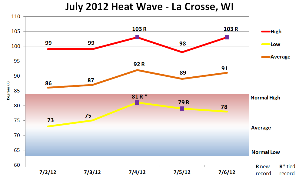
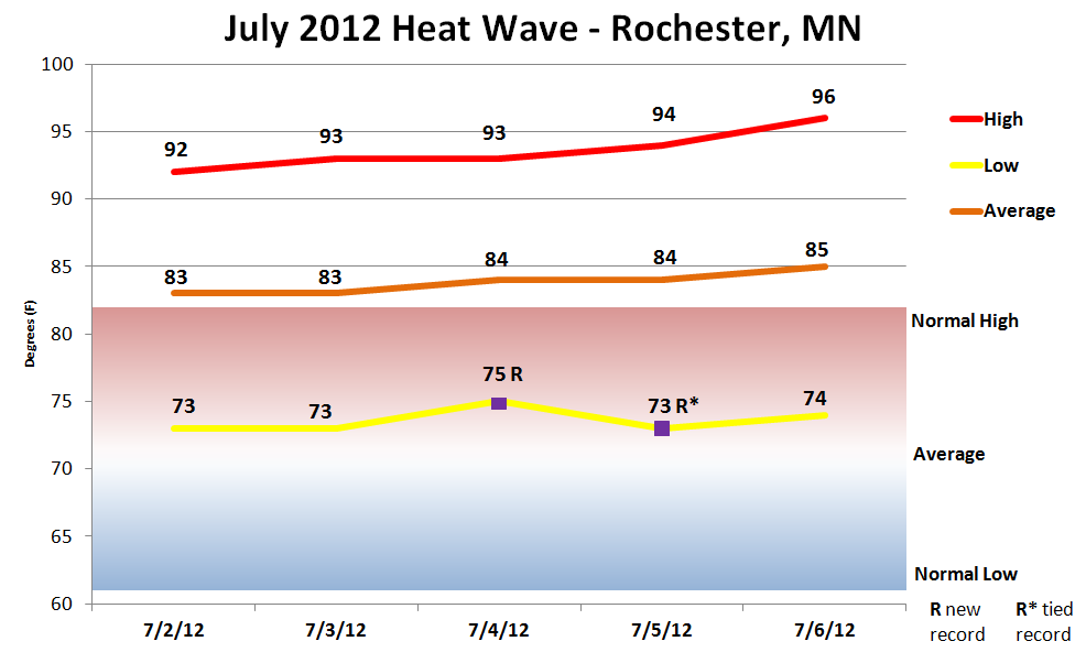
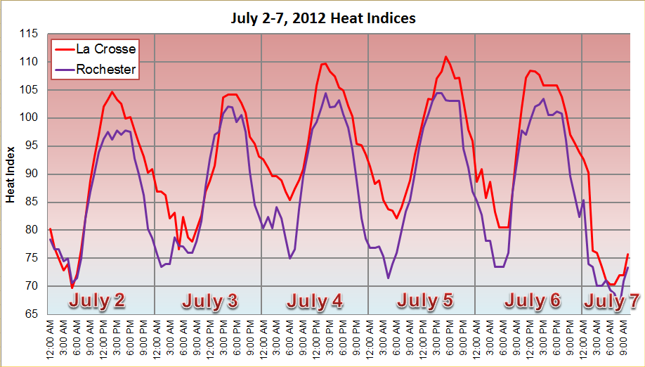
Highs climbed into the 90s for the 2nd through 6th, with some locations topping 100 on the 4th and 6th. When the high humidity was factored in, afternoon and early evening heat indices ranged 100 to 115. Heat Advisories were in effect on July 2nd for portions of the region, with Excessive Heat Warnings covering much of the Upper Mississippi River Valley from the 3rd through the 6th.
Tragically, the extreme heat also was deadly as several people lost their lives from heat related factors. Five people perished from July 4th through July 10th across western and central Wisconsin, mainly from lack of air conditioning in their residences.
Factors that led to the prolonged, oppressive heat wave:
| Media use of NWS Web News Stories is encouraged. Please acknowledge the NWS as the source of any news information accessed from this site.
|
|
La Crosse |
Rochester |
|||||||||||||||||||||||||||||||||||||||||||||||||||||||||||||
|
|
|||||||||||||||||||||||||||||||||||||||||||||||||||||||||||||
|
|
|||||||||||||||||||||||||||||||||||||||||||||||||||||||||||||
|
Records that were broken or tied in La Crosse, WI:
|
Records that were broken or tied in Rochester, MN:
|
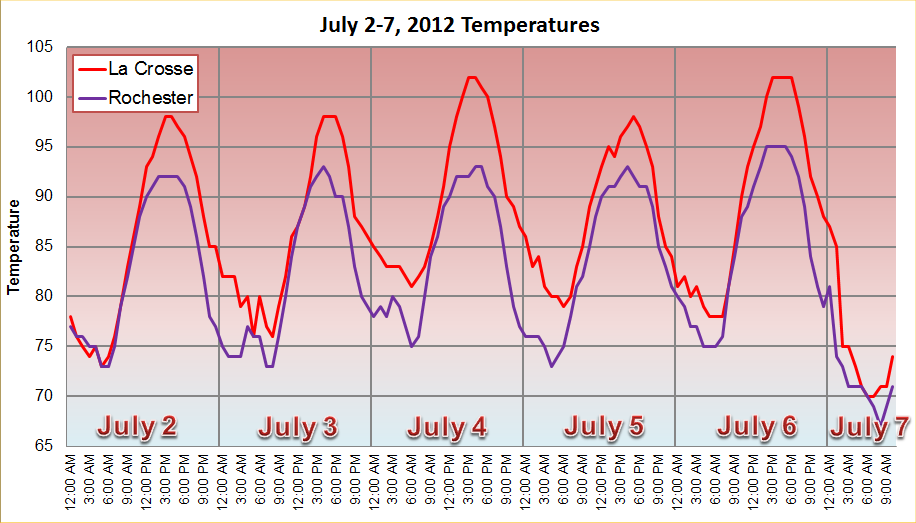
| Temperature - Heat Index - Dew Point Traces for La Crosse and Rochester |
 |
 |
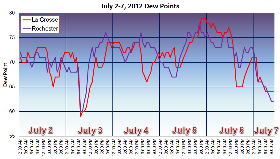 |
Numerous sites across west central Wisconsin, southeast Minnesota, and northeast Iowa saw repeated days of upper 90s to low 100s for high temperatures, with heat indices rising to the 100 to 115 range every afternoon and evening. The table below highlights some high temperatures from NWS Cooperative Observers and other automated reporting stations.
| July 2nd | July 3rd | July 4th | July 5th | July 6th | |
| Charles City, IA | 93 | 95 | 95 | 91 | 97 |
| Decorah, IA | 97 | 98 | 99 | 99 | 101 |
| Oelwein, IA | 91 | 93 | 93 | 93 | 95 |
| Osage, IA | 94 | 94 | 96 | 92 | 98 |
| Austin, MN | 95 | 95 | 97 | 93 | 99 |
| Preston, MN | 97 | 96 | 99 | 97 | 101 |
| Winona Airport, MN | 99 | 97 | 100 | 95 | 102 |
| Winona Dam 5A, MN | 96 | 96 | 99 | 94 | 100 |
| Boscobel, WI | 102 | 99 | 103 | 102 | 105 |
| Lancaster, WI | 96 | 96 | 98 | 99 | 99 |
| Medford, WI | 90 | 88 | 91 | 90 | 91 |
| Necedah, WI | 99 | 98 | 102 | 101 | 102 |
| Neillsville, WI | 95 | 92 | 97 | 94 | 97 |
| Owen, WI | 92 | 87 | 93 | 90 | 92 |
| Prairie du Chien | 97 | 97 | 100 | 99 | 102 |
| Richland Center, WI | 100 | 97 | 102 | 102 | 103 |
| Sparta, WI | 97 | 97 | 100 | 97 | 100 |


 Weather Story
 Weather Map
 Local Radar