
Strong to severe storms are expected to develop from mid afternoon through early evening. Damaging winds will be the main threat, but large hail and tornadoes are also possible. Have multiple ways to receive warnings and stay weather aware if you have outdoor plans. Read More >
Overview
|
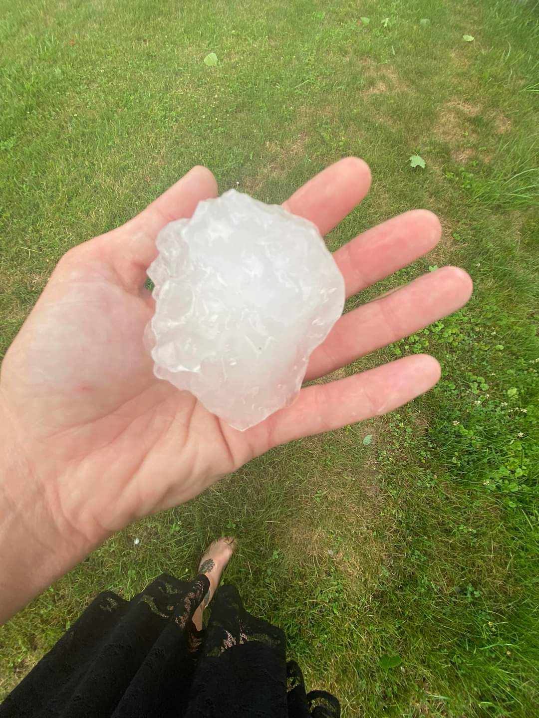
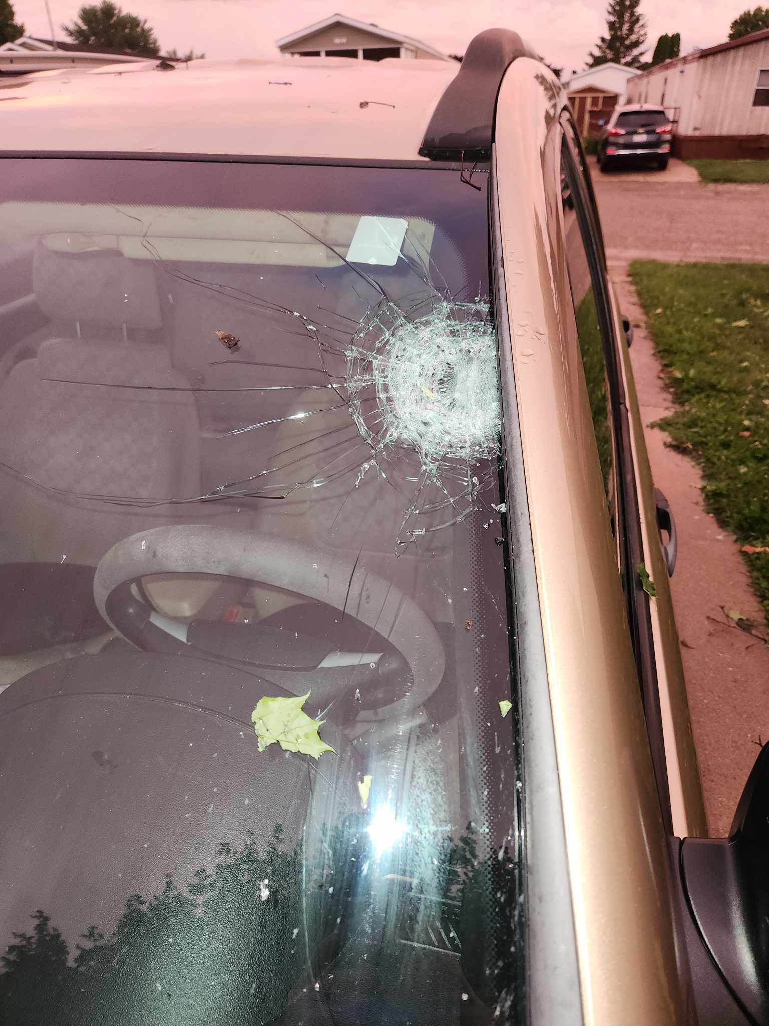
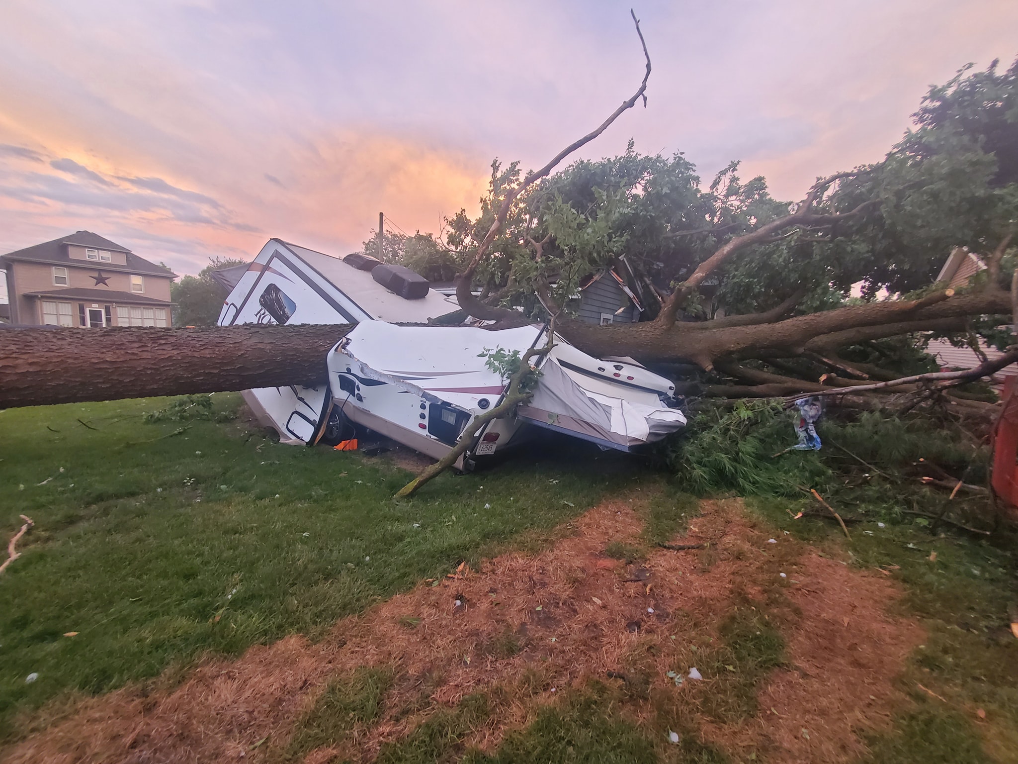
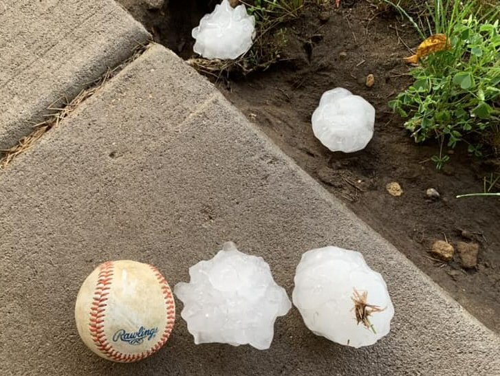
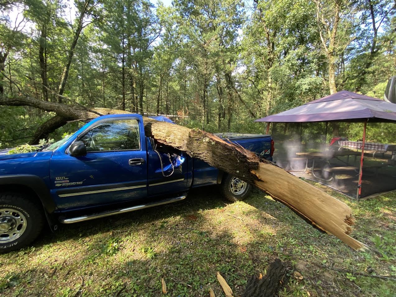
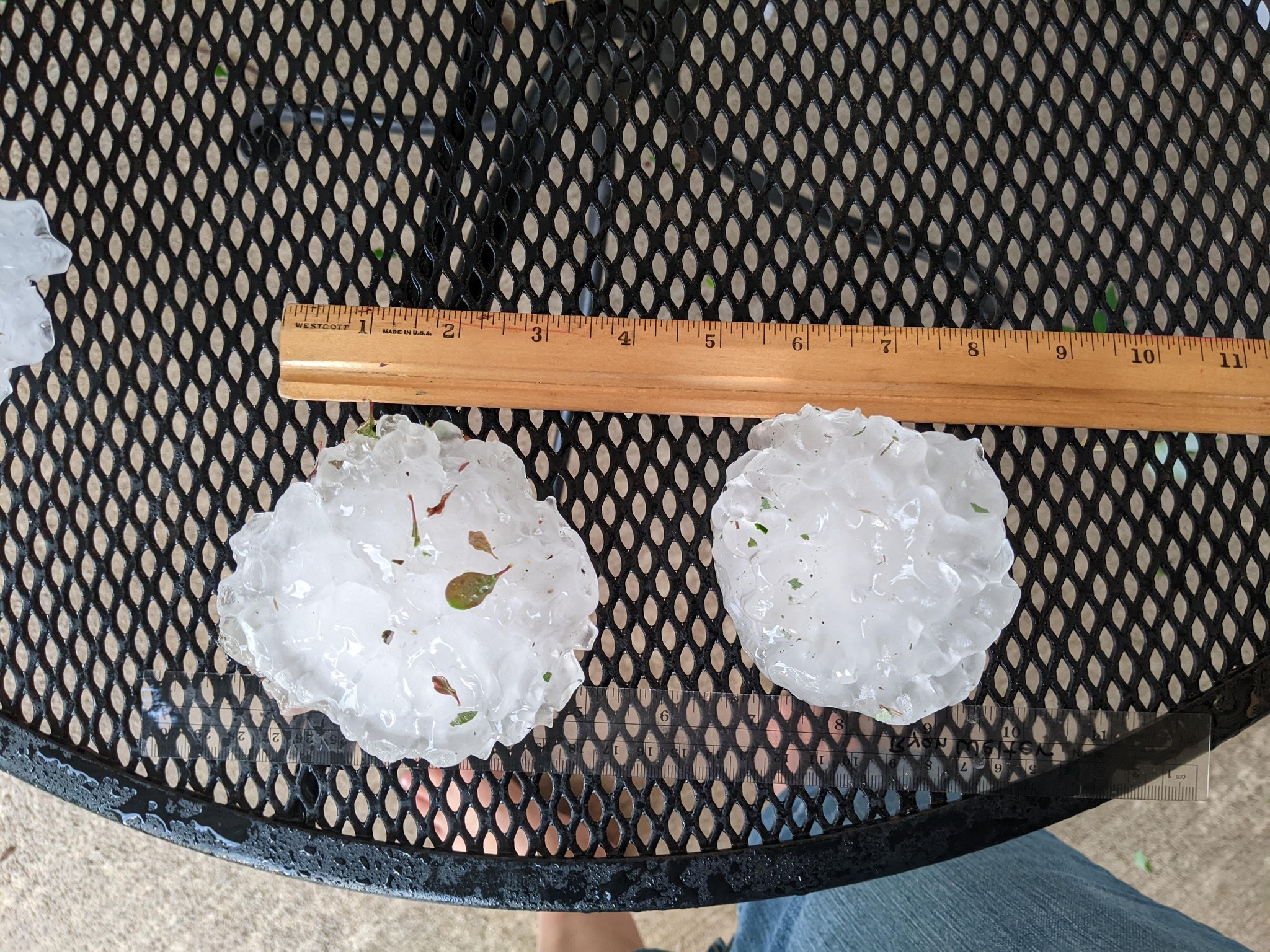
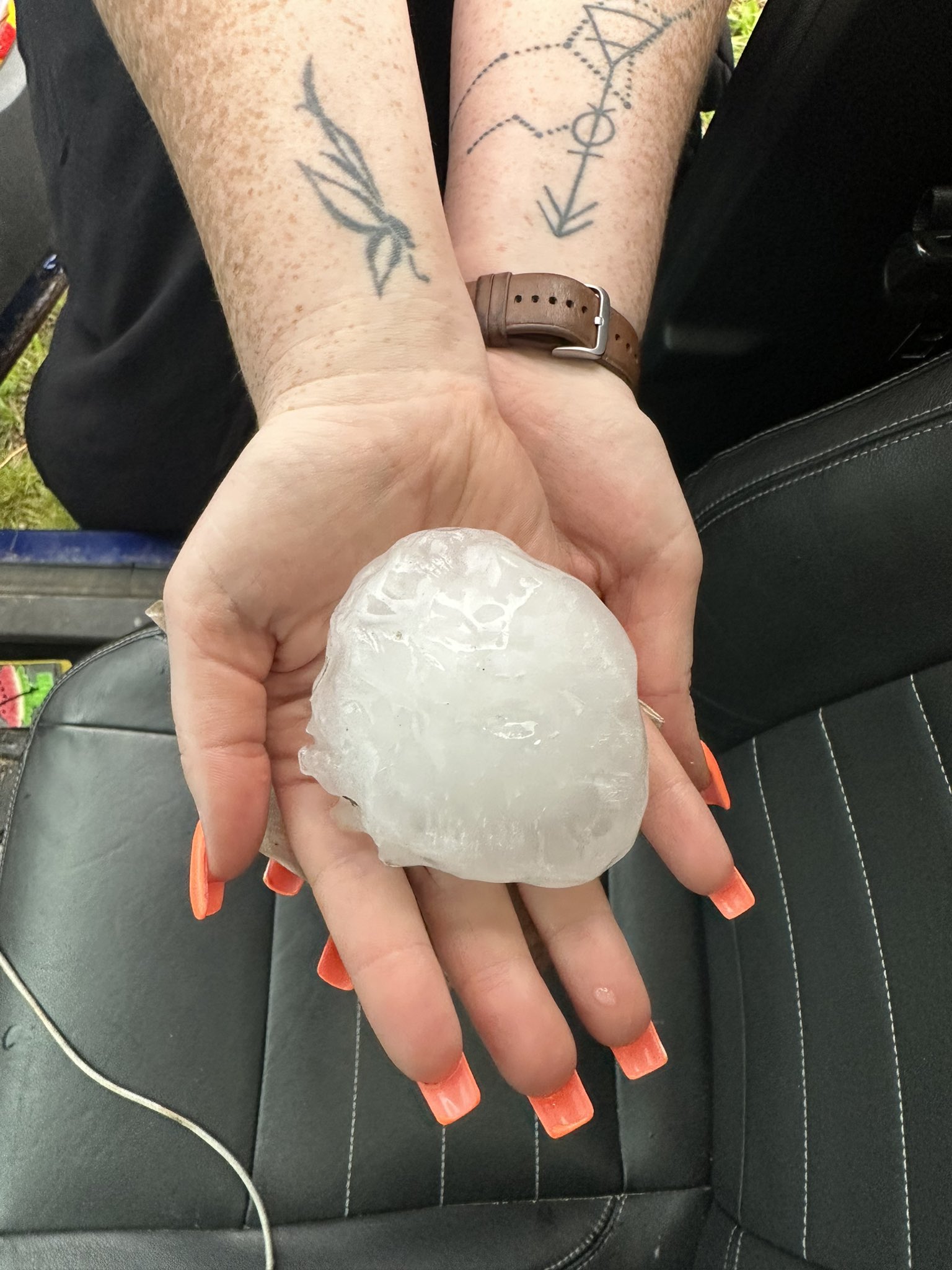
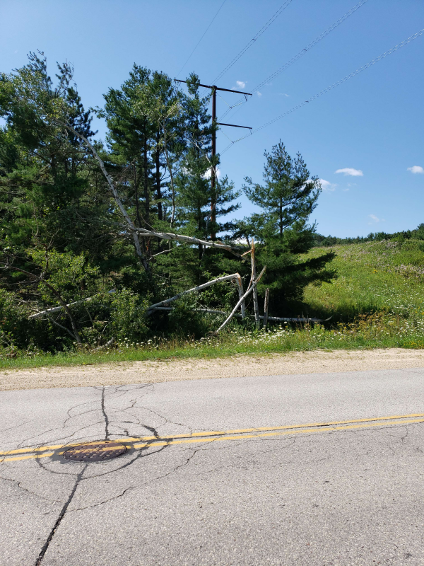
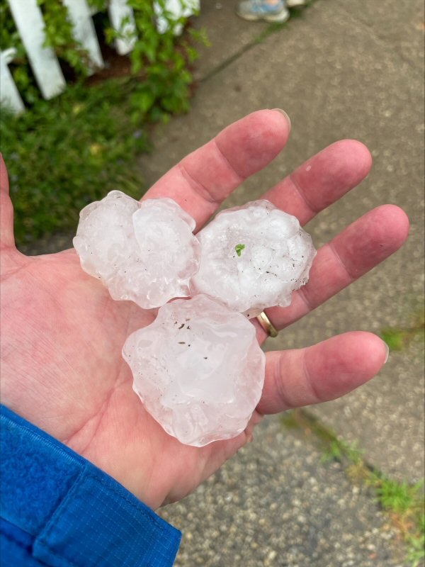
Hot and humid conditions set the stage for a round of severe thunderstorms that developed during the evening of Friday, July 28, 2023. There were two areas of storm development: one that initiated near the Twin Cities and another over northeast Iowa and southwest Wisconsin. A few intense supercells produced very large hail of 2 to 4 inches in diameter in the Medford, Galesville, Holmen, and West Salem, Wisconsin areas, along with some damaging winds. The storms eventually merged into bowing segments that produced more widespread wind damage along the Highway 21 corridor in west-central and central Wisconsin. Lone Rock, Wisconsin also sustained substantial wind damage with a 77 mph wind gust measured at the Lone Rock Tri-County Airport. |
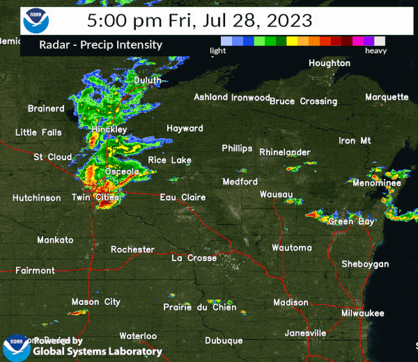 Radar animation from 5 to 10 pm CDT on Friday, July 28, 2023 |
Photos:
 |
 |
 |
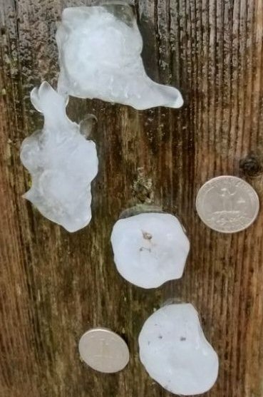 |
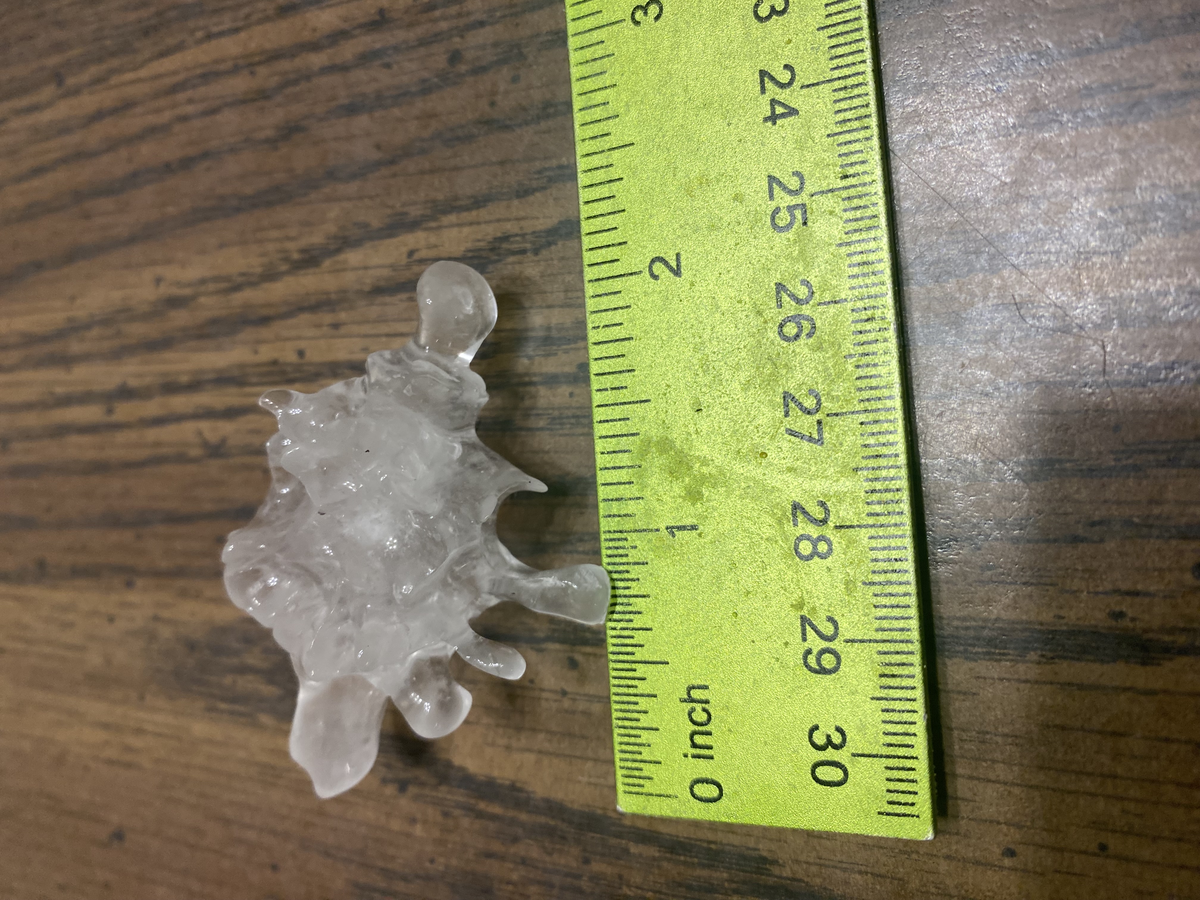
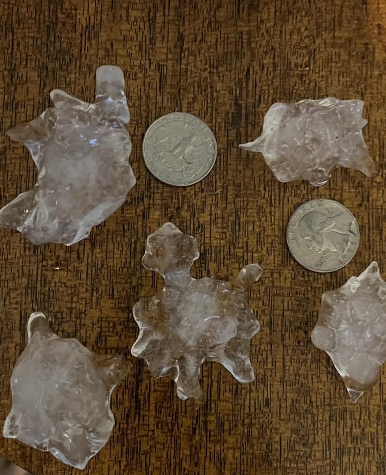
| Tennis Ball Size Hail West Salem, WI (anonymous) |
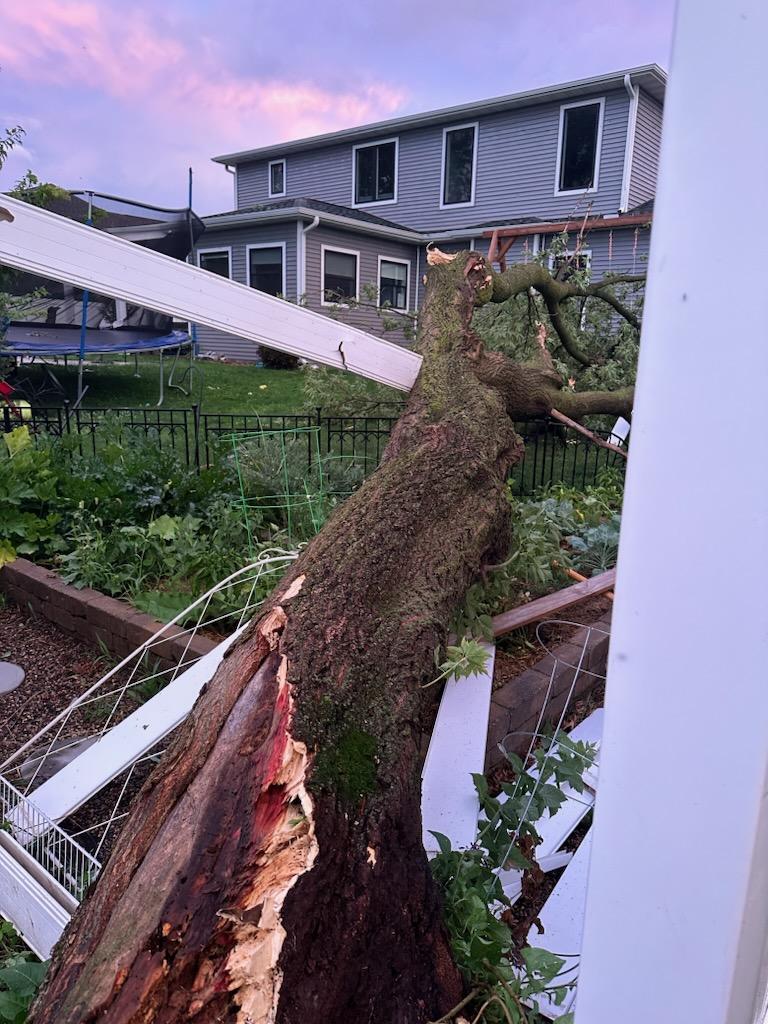
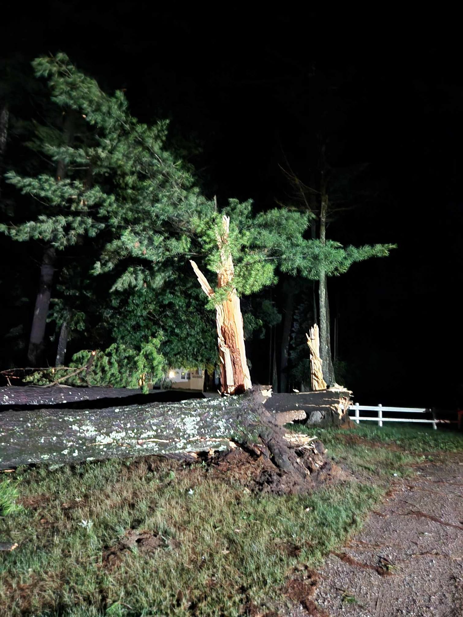
Tree Damage West Salem, WI (anonymous) |
Departing Severe Thunderstorm West Salem, WI (anonymous) |
Large Hail Town of Hamilton, WI (Mary Leske) |
 |
 |
 |
| Large Hail West Salem, WI (Fred Hill) |
Hail Damage to Vehicle West Salem, WI (Fred Hill) |
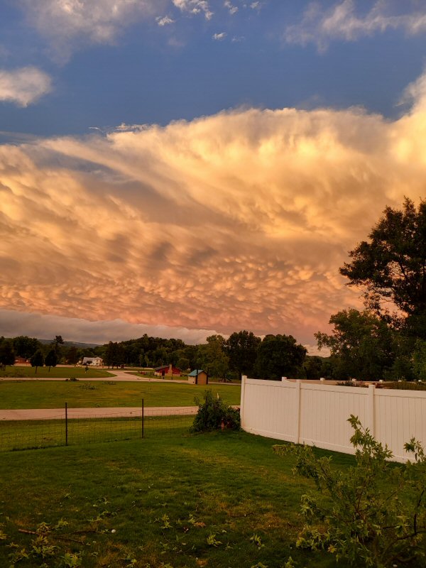
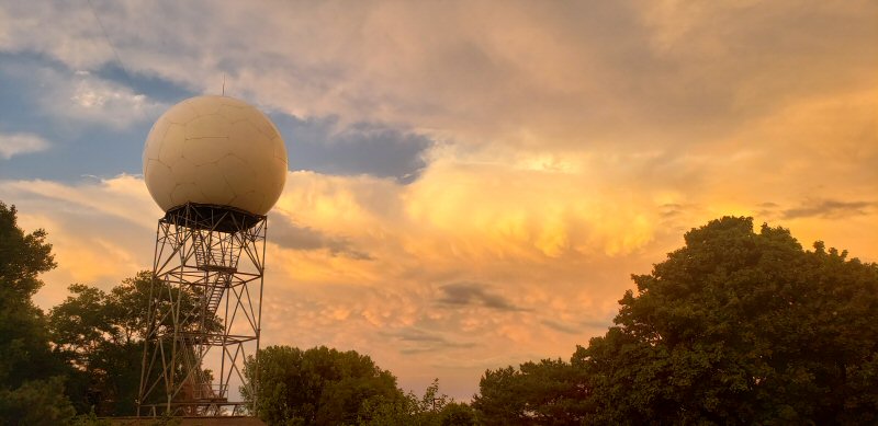
Departing Storms and Mammatus Clouds NWS La Crosse, WI (Mike Kurz) |
 |
 |
 |
 |
| Wind Damage West Salem, WI (Brandon Phillips) |
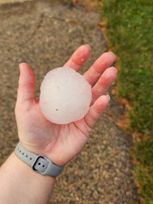
Baseball Size Hail West Salem, WI (Todd Hammes, Jr.) |
Wind Damage Warrens, WI (Monroe County EM) |
Baseball to Softball Size Hail Between West Salem/Bangor, WI (Natalie Elskamp) |
 |
 |
 |
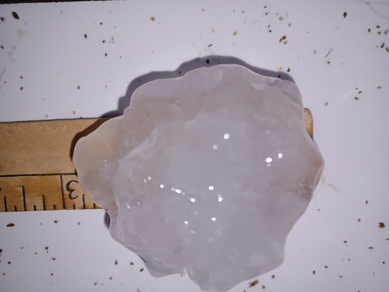 |
| 2-inch Hail Medford, WI (Lisa Maglio) |
Large Hail Medford, WI (Tracy Swedlund) |
Wind Damage Monroe Center, WI (Kathleen Specht) |
Baseball Size Hail Galesville, WI (Brenda Redsten) |
 |
 |
 |
 |
| Large hail Platteville, WI (Dana Priebusch) |
Tree damage I-94/Warrens, WI (NWS Survey) |
Tree damage McMullen County Park (NWS Survey) |
Large hail northern La Crosse Co. (Joe Langeberg) |
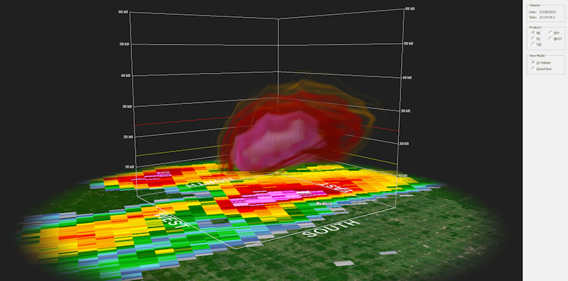
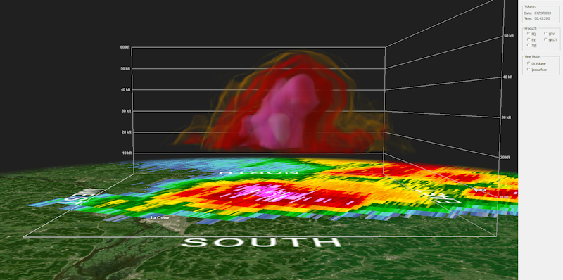
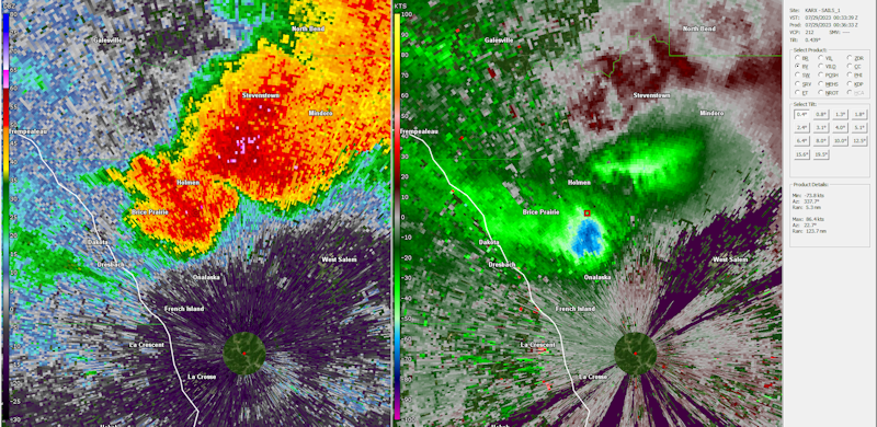
Radar:
 |
 |
 |
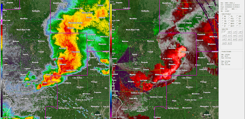 |
| KARX volumetric radar scan of the supercell that produced hail up to tennis ball size near Medford, WI. | KMKX volumetric radar scan of the supercell that produced hail up to 4" in diameter over La Crosse County. | Supercell produced an intense wind core just above ground level approaching Onalaska, WI. | Bow echo impacting Juneau and Adams counties produced widespread wind damage. |
Storm Reports
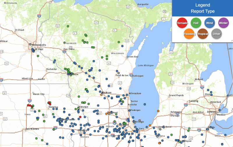
Storm reports from July 28, 2023
Preliminary Local Storm Report...Summary
National Weather Service La Crosse WI
527 PM CDT Sat Jul 29 2023

..TIME...   ...EVENT...      ...CITY LOCATION...     ...LAT.LON...
..DATE...   ....MAG....      ..COUNTY LOCATION..ST.. ...SOURCE....
            ..REMARKS..

0608 PM     Hail             7 NW Medford            45.21N 90.44W
07/28/2023  E1.00 inch       Taylor             WI   Public

            Report from mPING: Quarter (1.00 in.).


0613 PM     Hail             Fennimore               42.98N 90.66W
07/28/2023  M1.00 inch       Grant              WI   Law Enforcement

            Quarter size hail has been falling for 10 minutes.


0624 PM     Hail             Medford                 45.14N 90.35W
07/28/2023  E1.75 inch       Taylor             WI   Emergency Mngr

            Golfball size hail at the fairgrounds.


0625 PM     Hail             1 NE Medford            45.15N 90.33W
07/28/2023  M2.00 inch       Taylor             WI   Public


0625 PM     Hail             1 W Medford             45.14N 90.37W
07/28/2023  M2.50 inch       Taylor             WI   Broadcast Media


0625 PM     Tstm Wnd Dmg     1 SSE Wabasha           44.36N 92.04W
07/28/2023                   Wabasha            MN   Public

            Multiple large trees downed, some making
            roadways impassable. No power.


0629 PM     Tstm Wnd Dmg     1 NE Nelson             44.43N 91.99W
07/28/2023                   Buffalo            WI   Public

            Corrects previous tstm wnd dmg report from 1
            NE Nelson. Powerlines blown down. Riverland
            Energy Cooperative reports 618 people
            without power.


0645 PM     Hail             6 W Goodrich            45.14N 90.20W
07/28/2023  M0.75 inch       Taylor             WI   Public


0712 PM     Hail             Platteville             42.74N 90.48W
07/28/2023  M2.00 inch       Grant              WI   Trained Spotter

            Golf ball to hen egg size hail in Platteville.


0718 PM     Hail             2 NE Centerville        44.10N 91.43W
07/28/2023  E0.50 inch       Trempealeau        WI   Public

            Report from mPING: Half-inch (0.50 in.).


0719 PM     Hail             Galesville              44.08N 91.36W
07/28/2023  M3.00 inch       Trempealeau        WI   Trained Spotter

            Measured and confirmed with photo.


0721 PM     Hail             Galesville              44.08N 91.36W
07/28/2023  M1.75 inch       Trempealeau        WI   Public


0730 PM     Hail             4 NW Stevenstown        44.07N 91.23W
07/28/2023  M2.00 inch       Trempealeau        WI   Trained Spotter


0730 PM     Hail             4 NE New Amsterdam      44.03N 91.27W
07/28/2023  E1.75 inch       La Crosse          WI   NWS Employee


0730 PM     Tstm Wnd Gst     4 NW Black River Falls  44.34N 90.91W
07/28/2023  M67 MPH          Jackson            WI   Mesonet

            Mesonet station BRVW3 I-94 Eb.


0733 PM     Hail             Holmen                  43.96N 91.26W
07/28/2023  M1.75 inch       La Crosse          WI   Public


0733 PM     Hail             3 E Holmen              43.96N 91.20W
07/28/2023  M2.75 inch       La Crosse          WI   Public


0739 PM     Tstm Wnd Dmg     1 NW Onalaska           43.90N 91.24W
07/28/2023                   La Crosse          WI   Public

            Report from mPING: 1-inch tree limbs broken;
            Shingles blown off.


0740 PM     Tstm Wnd Gst     2 NNW Onalaska          43.91N 91.23W
07/28/2023  M50 MPH          La Crosse          WI   Public

            4 inch diameter branches down.


0740 PM     Tstm Wnd Dmg     Black River Falls       44.30N 90.85W
07/28/2023                   Jackson            WI   Public

            Several trees down.


0741 PM     Tstm Wnd Gst     1 NNW Onalaska          43.90N 91.23W
07/28/2023  M65 MPH          La Crosse          WI   Trained Spotter


0743 PM     Tstm Wnd Dmg     Onalaska                43.89N 91.23W
07/28/2023                   La Crosse          WI   Public


0745 PM     Hail             4 E Holmen              43.98N 91.19W
07/28/2023  E1.00 inch       La Crosse          WI   Public


0745 PM     Hail             1 NW West Salem         43.91N 91.09W
07/28/2023  M3.00 inch       La Crosse          WI   Public

            Verified by picture.


0746 PM     Tstm Wnd Dmg     West Salem              43.90N 91.09W
07/28/2023                   La Crosse          WI   Public

            Healthy tree split in half along with
            several large branches blown down in the
            area.


0746 PM     Hail             1 W West Salem          43.90N 91.09W
07/28/2023  M2.50 inch       La Crosse          WI   Public


0746 PM     Hail             1 WSW West Salem        43.90N 91.10W
07/28/2023  M2.00 inch       La Crosse          WI   Public


0746 PM     Hail             1 WSW West Salem        43.90N 91.10W
07/28/2023  M2.00 inch       La Crosse          WI   Public


0746 PM     Hail             1 WSW West Salem        43.90N 91.10W
07/28/2023  M2.00 inch       La Crosse          WI   NWS Employee


0746 PM     Hail             1 NNE West Salem        43.91N 91.07W
07/28/2023  M2.50 inch       La Crosse          WI   Public

            Tennis ball hail broke windows.


0747 PM     Tstm Wnd Dmg     West Salem              43.90N 91.07W
07/28/2023                   La Crosse          WI   Public

            Several large trees and branches blown down
            near the high school parking lot.


0747 PM     Tstm Wnd Dmg     1 NE West Salem         43.91N 91.07W
07/28/2023                   La Crosse          WI   Public

            Several trees blown down. One was blocking the road.


0747 PM     Tstm Wnd Dmg     West Salem              43.90N 91.07W
07/28/2023                   La Crosse          WI   Public

            Corrects previous tstm wnd dmg report from
            West Salem. Large branches down and several
            trees split or snapped off.


0750 PM     Hail             1 NE Barre Mills        43.84N 91.11W
07/28/2023  M1.25 inch       La Crosse          WI   Public

            Photo from social media.


0750 PM     Tstm Wnd Dmg     Bangor                  43.89N 90.99W
07/28/2023                   La Crosse          WI   Public

            Large tree down on house.


0750 PM     Hail             2 NE West Salem         43.91N 91.05W
07/28/2023  E2.75 inch       La Crosse          WI   Law Enforcement

            Law enforcement reports baseball size hail
            on Neshonoc Rd.


0750 PM     Hail             1 NE Barre Mills        43.84N 91.11W
07/28/2023  E1.50 inch       La Crosse          WI   Public

            Report from mPING: Ping Pong Ball (1.50 in.).


0752 PM     Hail             2 E West Salem          43.90N 91.04W
07/28/2023  M4.00 inch       La Crosse          WI   Public

            Social media photo with rulers for reference.


0752 PM     Hail             Bangor                  43.89N 90.99W
07/28/2023  M2.75 inch       La Crosse          WI   Public


0753 PM     Tstm Wnd Dmg     1 W Onalaska            43.88N 91.23W
07/28/2023                   La Crosse          WI   Public

            Report from mPING: 3-inch tree limbs broken;
            Power poles broken.


0755 PM     Hail             Bangor                  43.89N 90.99W
07/28/2023  M1.50 inch       La Crosse          WI   Law Enforcement


0755 PM     Flood            West Salem              43.90N 91.08W
07/28/2023                   La Crosse          WI   Public

            Street flooding reported.


0804 PM     Tstm Wnd Dmg     Millston                44.19N 90.64W
07/28/2023                   Jackson            WI   Public

            Multiple reports of large trees downed or uprooted.


0809 PM     Tstm Wnd Dmg     Warrens                 44.13N 90.50W
07/28/2023                   Monroe             WI   Amateur Radio

            Trees down in Warrens area.


0830 PM     Tstm Wnd Gst     1 WNW Necedah           44.03N 90.08W
07/28/2023  M71 MPH          Juneau             WI   Mesonet

            Mesonet station NEHW3 Necedah.


0831 PM     Tstm Wnd Dmg     Necedah                 44.02N 90.07W
07/28/2023                   Juneau             WI   Emergency Mngr

            Trees down and power outages reported.


0834 PM     Tstm Wnd Dmg     Monroe Center           44.12N 89.95W
07/28/2023                   Adams              WI   Public

            Mature pine trees downed. Power outages.


0834 PM     Tstm Wnd Dmg     1 SSW Strongs Prairie   44.05N 89.98W
07/28/2023                   Adams              WI   Public

            Multiple mature trees downed across Hwy 21
            between Arkdale and Necedah.


0835 PM     Tstm Wnd Gst     1 N Camp Douglas        43.93N 90.27W
07/28/2023  M58 MPH          Juneau             WI   AWOS

            AWOS station KVOK Volk Field.


0839 PM     Tstm Wnd Dmg     Mauston                 43.80N 90.08W
07/28/2023                   Juneau             WI   Emergency Mngr

            Trees down and reports of power outages.


0846 PM     Tstm Wnd Gst     1 E Wonewoc             43.66N 90.20W
07/28/2023  M72 MPH          Juneau             WI   Public


0916 PM     Hail             1 E Sextonville         43.28N 90.28W
07/28/2023  M1.00 inch       Richland           WI   Public


0920 PM     Hail             2 ESE Sextonville       43.27N 90.25W
07/28/2023  M1.75 inch       Richland           WI   Amateur Radio


0932 PM     Tstm Wnd Dmg     1 N Lone Rock           43.21N 90.20W
07/28/2023                   Richland           WI   Public

            Extensive damage reported to barns and
            trees. Nearby airport recorded 77mph wind
            gust.
Rainfall
Public Information Statement
National Weather Service La Crosse WI
547 PM CDT Sat Jul 29 2023

...Rainfall reports from yesterday evening...

Location                     Amount    Time/Date       Lat/Lon

...Iowa...

...Allamakee County...
Postville 5.5 NE             0.21 in   0700 AM 07/29   43.14N/91.49W
Lansing 4.1 NW               0.10 in   0700 AM 07/29   43.40N/91.29W

...Chickasaw County...
Fredericksburg 0.3 S         0.84 in   0800 AM 07/29   42.96N/92.20W
New Hampton                  0.52 in   0700 AM 07/29   43.06N/92.32W
New Hampton 0.4 SW           0.42 in   0700 AM 07/29   43.06N/92.32W
Ionia 2W                     0.07 in   0700 AM 07/29   43.03N/92.50W

...Clayton County...
Mcgregor                     0.43 in   0919 AM 07/29   43.02N/91.19W
Monona                       0.36 in   0919 AM 07/29   43.04N/91.39W
Guttenberg Dam 10            0.30 in   0700 AM 07/29   42.79N/91.10W
Big Spring Fish Hatchery     0.28 in   0900 AM 07/29   42.91N/91.47W
McGregor 6.4 WNW             0.17 in   0643 AM 07/29   43.07N/91.29W
Elkader 6SSW                 0.10 in   0700 AM 07/29   42.78N/91.45W
Littleport                   0.09 in   0845 AM 07/29   42.75N/91.37W
Elkader 6.8 WSW              0.06 in   0600 AM 07/29   42.81N/91.52W

...Fayette County...
Waucoma 3.2 S                0.80 in   0700 AM 07/29   43.01N/92.03W
Fayette                      0.48 in   0645 AM 07/29   42.88N/91.83W
Eldorado 1E - Turkey River   0.48 in   0845 AM 07/29   43.05N/91.81W

...Floyd County...
Nora Springs 2.4 SSE         0.65 in   0700 AM 07/29   43.11N/92.99W
2 NE Dougherty               0.43 in   0915 AM 07/29   42.95N/93.01W
Charles City                 0.37 in   0908 AM 07/29   43.05N/92.67W
Nashua 2SW                   0.18 in   0700 AM 07/29   42.94N/92.57W

...Winneshiek County...
1 ENE Jackson Junction       0.87 in   0920 AM 07/29   43.11N/92.04W
Decorah 4.9SE                0.13 in   0700 AM 07/29   43.26N/91.70W

...Minnesota...

...Olmsted County...
Rochester 5.8 ENE            0.23 in   0700 AM 07/29   44.06N/92.38W

...Wabasha County...
Lake City                    0.46 in   0900 AM 07/29   44.44N/92.28W
Wabasha 6.2 WNW              0.35 in   0700 AM 07/29   44.39N/92.16W
Lake City 0.7 SE             0.27 in   0800 AM 07/29   44.43N/92.27W
1 N Kellogg                  0.25 in   0900 AM 07/29   44.32N/92.00W
Kellogg 0.1 N                0.20 in   0700 AM 07/29   44.31N/92.00W
Lake City                    0.11 in   0902 AM 07/29   44.32N/92.44W

...Wisconsin...

...Adams County...
Oxford 4.0 W                 0.85 in   0700 AM 07/29   43.79N/89.64W
Grand Marsh 1.0 W            0.30 in   0700 AM 07/29   43.89N/89.73W

...Buffalo County...
1 NE Nelson                  1.50 in   0640 PM 07/28   44.43N/91.99W
Mondovi 12.1 SSE             0.84 in   0615 AM 07/29   44.40N/91.60W
Independence 9.1 NW          0.44 in   0700 AM 07/29   44.46N/91.55W

...Clark County...
Greenwood 0.6 NNW            0.38 in   0700 AM 07/29   44.77N/90.60W

...Crawford County...
Prairie Du Chien  Airport    0.38 in   0915 AM 07/29   43.02N/91.12W
Steuben 4SE                  0.25 in   0800 AM 07/29   43.13N/90.84W
Prairie Du Chien 1.4 N       0.07 in   0700 AM 07/29   43.06N/91.14W

...Grant County...
Platteville                  1.22 in   0910 AM 07/29   42.74N/90.46W
1 NE Platteville             1.00 in   0742 AM 07/29   42.75N/90.46W
Fennimore                    0.82 in   0919 AM 07/29   42.98N/90.66W
Dickeyville 0.1 SW           0.69 in   0700 AM 07/29   42.62N/90.59W
Lancaster                    0.66 in   0841 AM 07/29   42.83N/90.69W
Prairie Du Chien 9.9 SE      0.64 in   0700 AM 07/29   42.95N/90.99W
Patch Grove 0.1 NNW          0.55 in   0700 AM 07/29   42.94N/90.97W
Platteville Municipal Airpor 0.50 in   0715 AM 07/29   42.68N/90.43W
Bloomington 3.5 N            0.48 in   0646 AM 07/29   42.94N/90.92W
Cassville 7.8 ENE            0.48 in   0700 AM 07/29   42.75N/90.84W
Muscoda 0.5 WSW              0.25 in   0827 AM 07/29   43.18N/90.44W
Muscoda                      0.25 in   0905 AM 07/29   43.19N/90.46W

...Jackson County...
1 E Black River Falls        1.38 in   0815 AM 07/29   44.30N/90.73W
Melrose 3.6 W                0.63 in   0700 AM 07/29   44.13N/91.07W

...Juneau County...
New Lisbon                   1.61 in   0901 AM 07/29   43.87N/90.17W
3 ESE Lemonweir              1.36 in   0530 AM 07/29   43.77N/89.96W
1.0 E Mauston                1.15 in   0800 AM 07/29   43.79N/90.06W
Necedah                      1.13 in   0848 AM 07/29   44.03N/90.08W
0.6 W Necedah                1.13 in   0848 AM 07/29   44.02N/90.08W
Mauston Airport              0.23 in   0915 AM 07/29   43.83N/90.13W

...La Crosse County...
Onalaska 2N                  0.58 in   0700 AM 07/29   43.91N/91.23W
Onalaska 1.9 E               0.41 in   0700 AM 07/29   43.89N/91.18W
Onalaska                     0.41 in   0906 AM 07/29   43.89N/91.18W
Coon Valley 4.5 NNW          0.15 in   0700 AM 07/29   43.76N/91.06W

...Monroe County...
Warrens 4.7 WSW              1.51 in   0700 AM 07/29   44.10N/90.59W
0.5 SW Sparta                0.43 in   0650 AM 07/29   43.94N/90.82W

...Richland County...
1 SSE Richland Center        0.46 in   0919 AM 07/29   43.32N/90.38W
Cazenovia 4.4 SSW            0.36 in   0700 AM 07/29   43.47N/90.23W
Richland Center 4 N          0.21 in   0700 AM 07/29   43.40N/90.39W

...Taylor County...
Westboro                     1.30 in   0905 AM 07/29   45.37N/90.31W
Medford 0.8 ENE              1.16 in   0700 AM 07/29   45.14N/90.33W
6 W Goodrich                 1.03 in   0809 AM 07/29   45.14N/90.20W
3 NE Lublin                  0.69 in   0814 AM 07/29   45.11N/90.69W
Medford Airport              0.64 in   0915 AM 07/29   45.10N/90.30W
Medford                      0.47 in   0900 AM 07/29   45.30N/90.30W
0.6 SE Medford               0.20 in   0845 AM 07/29   45.13N/90.34W

...Trempealeau County...
Osseo 0.4 E                  2.08 in   0600 AM 07/29   44.58N/91.21W
Blair (IFLOWS)               1.22 in   0255 AM 07/29   44.30N/91.23W
0.8 SW Pigeon Falls (IFLOWS) 1.18 in   0517 AM 07/29   44.42N/91.22W
Ettrick 4.0 WNW              1.04 in   0652 AM 07/29   44.19N/91.34W
Whitehall (IFLOWS)           0.91 in   0848 AM 07/29   44.37N/91.32W
Trempealeau 7.6 NNW          0.23 in   0700 AM 07/29   44.11N/91.48W
Trempealeau                  0.21 in   0906 AM 07/29   44.07N/91.51W
1 NW Trempealeau             0.16 in   0700 AM 07/29   44.03N/91.46W

...Vernon County...
Hillsboro 2 SW               0.61 in   0700 AM 07/29   43.63N/90.38W
Ontario                      0.31 in   0800 AM 07/29   43.72N/90.59W
La Farge                     0.06 in   0900 AM 07/29   43.60N/90.63W

Observations are collected from a variety of sources with varying
equipment and exposures. We thank all volunteer weather observers
for their dedication. Not all data listed are considered official.
Additional Information
Services
 |
 |
 |
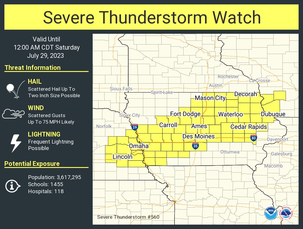 |
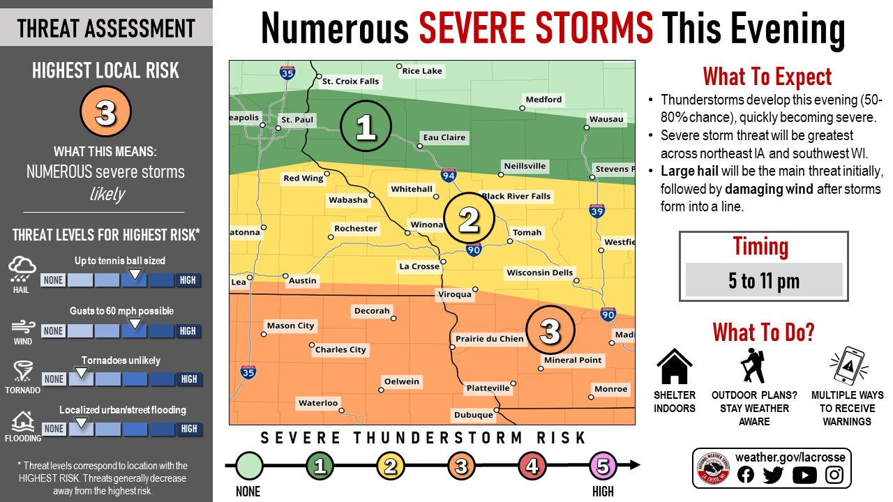
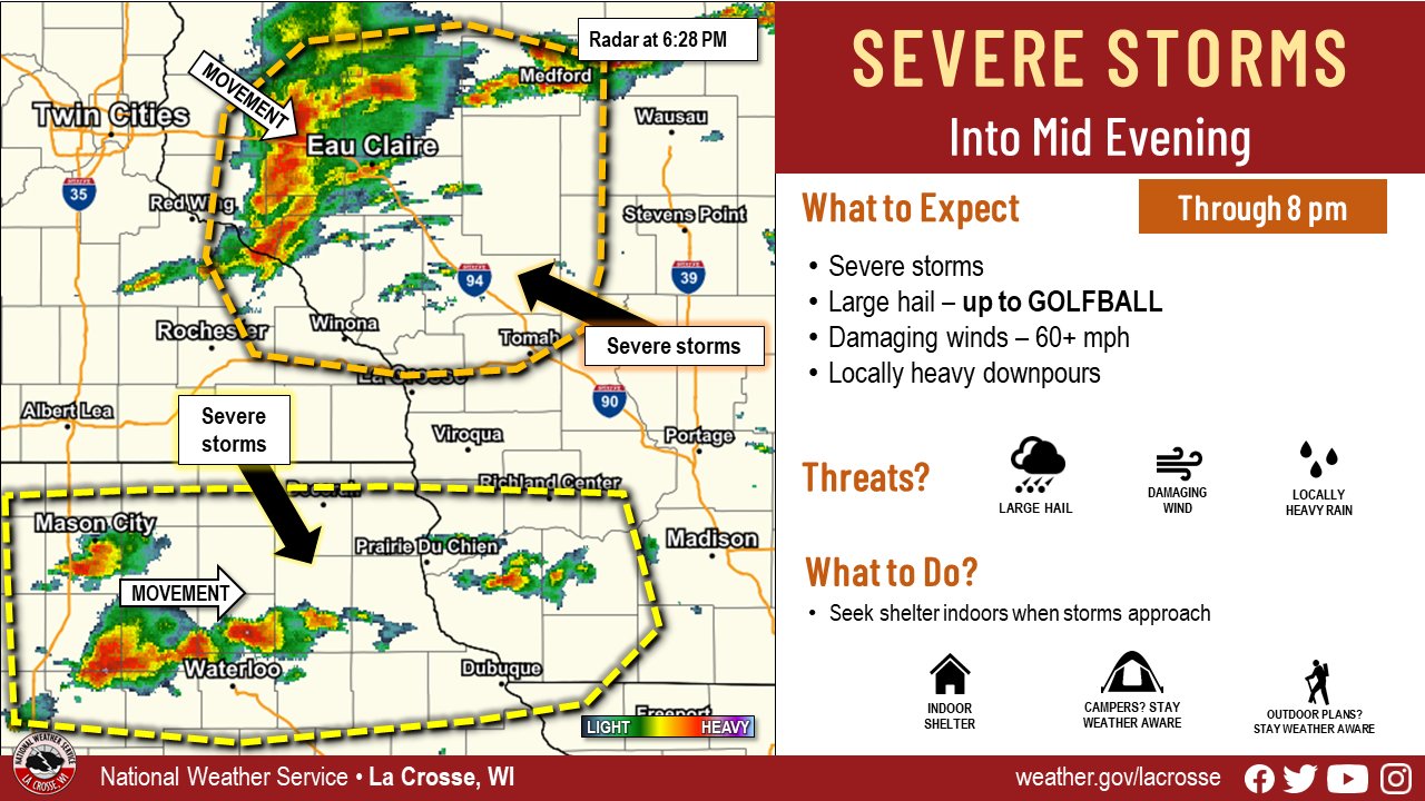
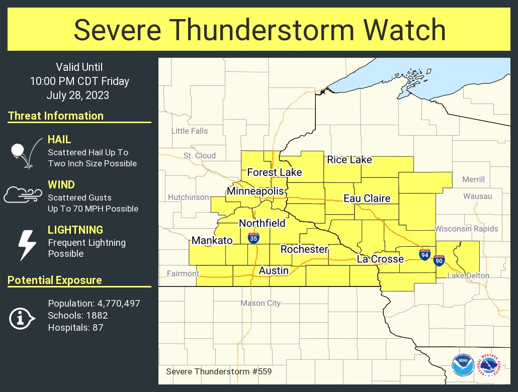
| Weather Story graphic issued July 28 | Graphic highlighting developing storms during the evening of July 28 | Severe thunderstorm watch issued at 4:06 PM July 28 | Severe thunderstorm watch issued at 5:00 PM July 28 |
 |
 |
 |
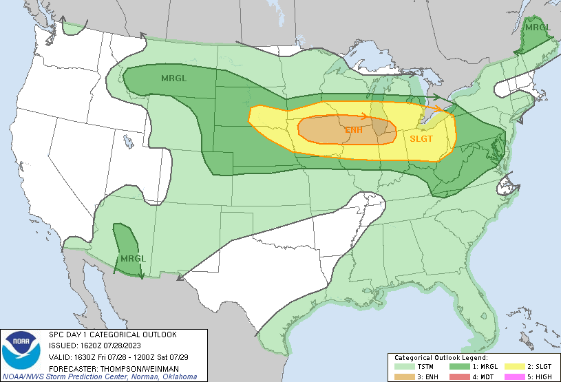 |
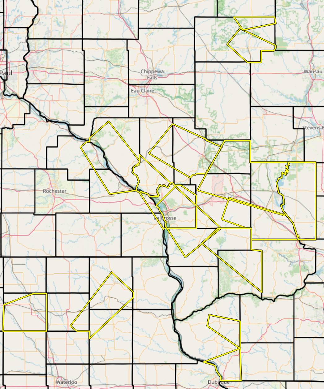
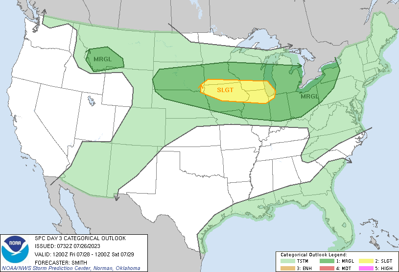
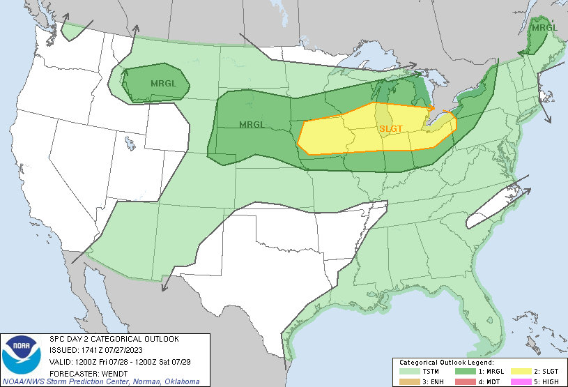
| All local severe thunderstorm warnings from July 28 (courtesy of Iowa Environmental Mesonet) | SPC Day 3 Outlook for July 28 issued on July 26 | SPC Day 2 Outlook for July 28 issued on July 27 | SPC Day 1 Outlook from July 28 |
Summaries from other NWS Offices
 |
Media use of NWS Web News Stories is encouraged! Please acknowledge the NWS as the source of any news information accessed from this site. |
|


 Weather Story
 Weather Map
 Local Radar