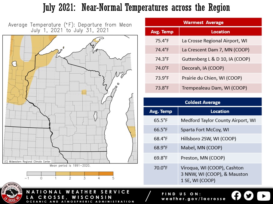
During July 2021, temperatures averaged near-normal & rainfall was highly variable across the Upper Mississippi River Valley.
Monthly average temperatures for July ranged from 65.5°F at Medford, WI to 75.4°F at La Crosse Regional Airport. In most locations, July (typically our hottest month of the year) was slightly cooler than June. This has only occurred 11 times since the early 1870s. The last time was 2014. The hottest temperature was 96°F just south of Theilman, MN on July 6, and the coldest temperature was 42°F at Sparta Fort McCoy Airport on July 11.
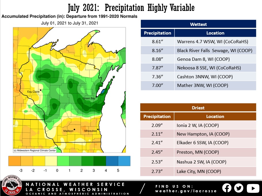
Like May & June, the July 2021 rainfall was highly variable across the Upper Mississippi River Valley. Rainfall totals ranged from 2.09” just west of Ionia, IA to 8.61” near Warrens, WI. The driest areas continued to be found in southeast Minnesota, northeast Iowa, and southwest Wisconsin where rainfall deficits were 1 to 3". Meanwhile, areas along and north of Interstate 90 in Wisconsin saw rainfall surpluses up to 3". Typically, the July rainfall is around 4" north of Interstate 94 and ranges from 4 to 5" across the remainder of the region.
 |
 |
| July 2021 Temperature Anomalies |
July 2021 Rainfall Anomalies |
More details for La Crosse, WI, and Rochester, MN can be found below.
La Crosse WI...
July 2021 was Slightly Warmer and Wetter-than-Normal in La Crosse WI
July 2021 Highlights...
- The average temperature was 75.4°F at La Crosse Regional Airport. This was 0.4°F warmer than the 1981-2020 normal of 75.0°F.
- July was 1.2°F cooler than June 2021 (76.6 degrees). This was the first July to be cooler than June since 2014 (July was 1.1°F cooler than June in that year) and only the 11th time that this has occurred. The other years were 1873, 1884, 1891, 1933, 1956, 1971, 1994, and 2014. The largest difference is 3.6°F in 1971 (June 72.1°F and July 68.5°F).
- The hottest temperature was 95°F on July 5 and the coldest temperature was 53°F on July 11.
|
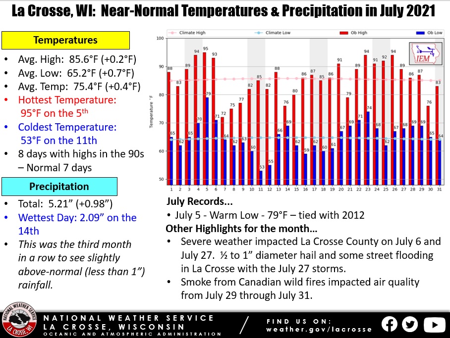 |
- A total of 5.21" of rain fell during the month. This was nearly an inch (0.98") wetter than the 1991-2020 normal of 4.23". This made it the third month in a row to be slightly wetter (less than an inch) than normal.
- Rain fell on 13 days (11 with measurable and 2 with a trace). The wettest day was 2.09" on July 14.
- Severe weather impacted La Crosse County on July 6 and July 27. Half to 1" diameter hail and some street flooding occurred in La Crosse with the July 27 storms.
- Smoke from Canadian wildfires impacted the air quality from July 29 through July 31.
Records...
Looking Ahead to August...
- The normal high temperature in La Crosse starts off at 85°F on the 1st and falls to 81°F by the end of the month. The normal low temperature starts off at 64°F on the 1st and falls to 60°F by the end of the month. The normal mean temperature for the month is 72.8°F. La Crosse’s hottest August occurred in 1947 with an average temperature of 78.3°F, and their coldest August occurred in both 1927 and 1915 with an average temperature of 64.8°F.
- For August, the hottest temperature ever recorded was 105°F on August 1, 1988, and the coldest temperature was 35°F on August 30, 1915. There are typically 4 days with temperatures at or above 90°F.
- The average precipitation for August is 3.90". The wettest August occurred in 2007 when 13.75" of rain fell and the driest occurred in 1894 when 0.35" of rain fell. The wettest August day was 4.05" on August 18, 2007. Normally, there are 6 days with thunderstorms.
- Valley fog is quite prevalent in the area. On average, this fog reduces the visibility to a quarter-mile or less at the airport on 3 days.
Rochester, MN...
July 2021 was Slightly Warmer and Drier-than-Normal in Rochester MN
July 2021 Highlights...
- The average temperature was 71.4°F at Rochester International Airport. This was 0.9°F warmer than the 1981-2020 normal of 70.5°F.
- July was 1.6°F cooler than June 2021 (73 degrees). This was the first July to be cooler than June since 2014 (July was 1.3°F cooler than June in that year) and only the 10th time that this has occurred. The other years were 1911, 1933, 1956, 1971, 1991, 1992, 1994, 2009, and 2014. The largest difference is 4.4 degrees in 1971 (June 71.4°F and July 67°F).
- The hottest temperature was 91°F on July 5 and the coldest temperature was 55°F on July 12.
|
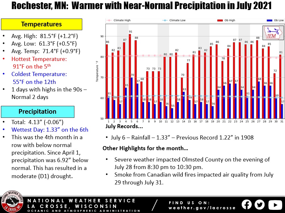 |
- A total of 4.13" of rain fell during the month which was 0.06" drier than the 1991-2020 normal of 4.19". This was the 4th month in a row with below-normal precipitation. Since April 1, precipitation was 6.63" below normal. This has resulted in a moderate (D1) drought.
- Rain fell on 12 days (10 with measurable and 2 with a trace). The wettest day was 1.33" on July 6.
- Severe weather impacted Olmsted County on the evening of July 28 from 8:30 p.m. to 10:30 p.m..
- Smoke from Canadian wildfires impacted the air quality from July 29 through July 31.
Records...
- Rainfall Records...
- July 6 - 1.33" - Previous Record 1.22" in 1908
Looking Ahead to August...
- The normal high temperature in Rochester falls from 79°F on the 1st to 76°F by the end of the month. The normal low temperature falls from 60°F on the 1st to 56°F by the end of the month. The normal mean temperature for the month is 68.2°F. Rochester’s hottest August occurred in 1947 with an average temperature of 77°F, and their coldest August occurred in 1992 with an average of 63.1°F.
- For August, the hottest temperature ever recorded was 100°F on August 3, 1930, August 15, 1936, August 4, 1947, August 23, 1948, and August 24, 1948, and the coldest temperature was 32°F on August 30, 1915. Normally, there is only 1 day with temperatures at or above 90°F.
- The average precipitation for August is 4.12". The wettest August occurred in 2007 when 14.07" of rain fell and the driest occurred in 1941 when 0.31" of rain fell. The wettest August day was 5.16" on August 18, 2007. Normally, there are 6 days with thunderstorms.

