
Tropical Storm Bertha could bring tropical storm conditions to portions of the Florida Panhandle and Alabama coast through Wednesday, where a Tropical Storm Watch and Storm Surge Watch is in effect. Numerous severe thunderstorms with heavy rainfall are expected from the Ohio Valley into the Mid-Atlantic and Northeast Tuesday. Read More >
Overview
|
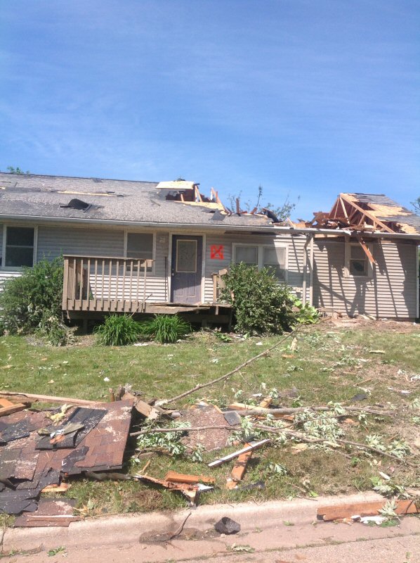
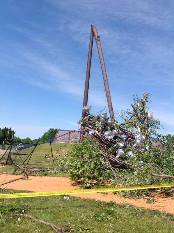
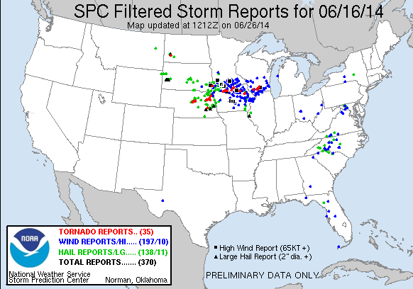
Severe storms moved through much of the region on the evening of June 16th, 2014, producing torrential rainfall and strong to damaging winds. The line of storms developed in southwest Minnesota and northwest Iowa and drove eastward through the evening. Some hail occurred too, with golf ball size hail reported near Strawberry Point, Iowa. The hardest hit area was Platteville, WI where 5 injuries occurred, cars were flipped and some buildings destroyed. The storms also produced some flash flooding in portions of southeast Minnesota where 2-4 inches of rain fell in 2 hours or less. The storms were the result of a strong flow of warm, moist air from the Gulf, a wavering west to east running frontal boundary, and a very unstable atmosphere. |
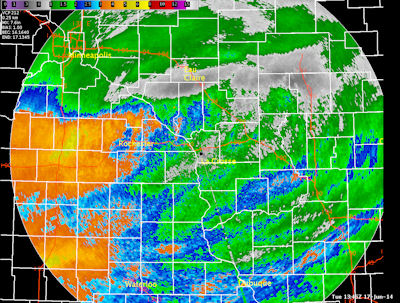
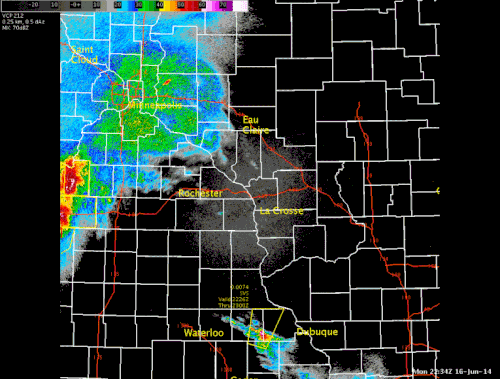 Radar loop from 5:30 to 11:45 p.m. |
Tornadoes:
|
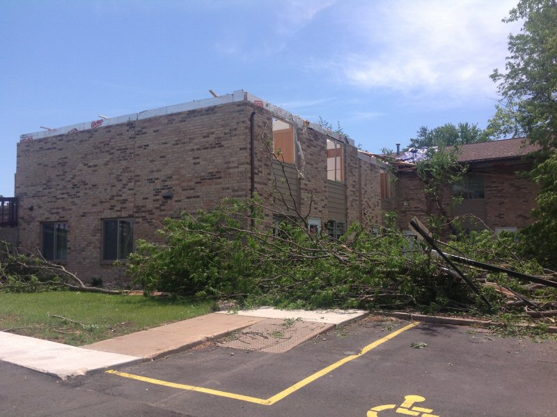
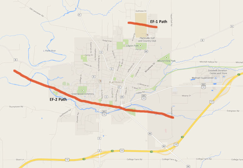
Tornado #1 - Platteville, WI
|
||||||||||||||||
|
||||||||||||||||
|
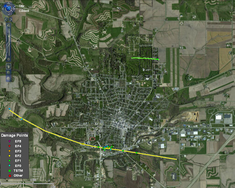
Tornado #2 - Platteville, WI
Track Map 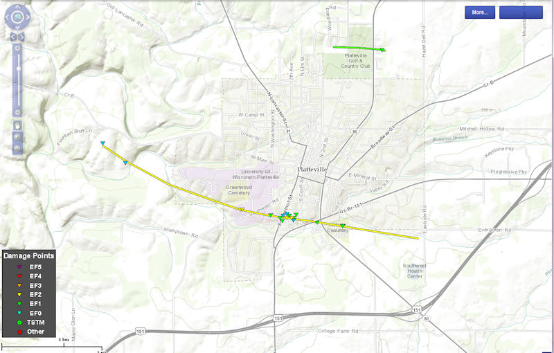  |
||||||||||||||||
The Enhanced Fujita (EF) Scale classifies tornadoes into the following categories:
| EF0 Weak 65-85 mph |
EF1 Moderate 86-110 mph |
EF2 Significant 111-135 mph |
EF3 Severe 136-165 mph |
EF4 Extreme 166-200 mph |
EF5 Catastrophic 200+ mph |
 |
|||||
Photos:
 |
 |
 |
 |
| Damage on UW-Platteville campus. (NWS Survey) |
Damage on UW-Platteville campus. (NWS Survey) |
Just east of UW-Platteville campus. (NWS Survey) |
Damage at the UW Platteville football stadium. (NWS Survey) |
 |
 |
||
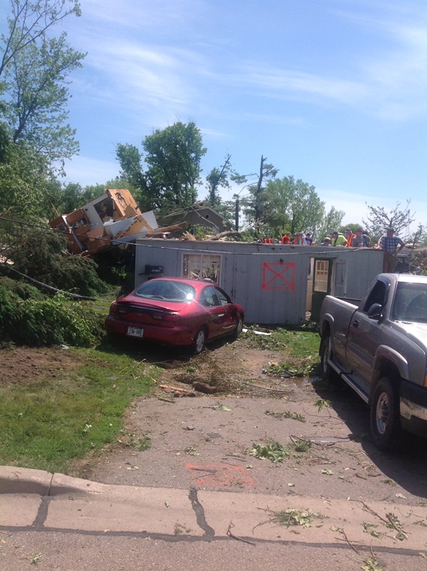
| Northeast side of Platteville. (NWS Survey) |
House damage just east of UW-Platteville campus. (NWS Survey) |
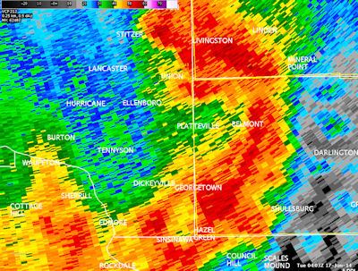
Radar:
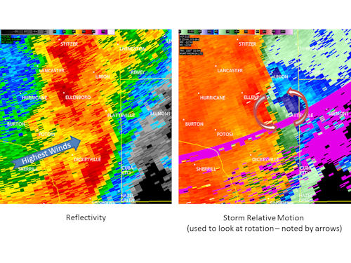
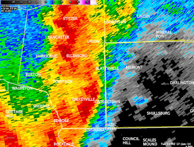
A "bow echo" was traversing across southern Grant county. The strongest winds are taking place at the apex of the bow and where lower values of reflectivity (noted by yellow and green) are coming into the bow. Meanwhile, rotation can be seen on the northern end of the bow echo, which is a typical spot where tornadoes can form. These types of tornadoes are not like more dangerous Supercell tornadoes. They are difficult to see and difficult to warn for. They are also typically more short-lived and last fewer minutes than other tornadoes. In addition, the radar is scanning almost 8000 ft above the ground at Platteville due to the curvature of the Earth. Time of the radar imagery was 10:49 p.m. Monday June 16, 2014.
 |
 |
 |
 |
| Radar at 10:49 p.m. at the time tornadoes were hitting UW-Platteville. | Radar at 11:03 p.m. just after storms moved through Platteville, WI. | Rainfall estimates off radar. |
Storm Reports
PRELIMINARY LOCAL STORM REPORT...SUMMARY
NATIONAL WEATHER SERVICE LA CROSSE WI
1210 PM CDT TUE JUN 17 2014

...TIME...  ...EVENT...      ...CITY LOCATION...     ...LAT.LON...
...DATE...  ....MAG....      ..COUNTY LOCATION..ST.. ...SOURCE....
            ..REMARKS..

0701 PM     TSTM WND DMG     2 SE AUSTIN             43.65N 92.95W
06/16/2014                   MOWER              MN   PUBLIC

            SEMI BLOWN OVER ON U.S. HIGHWAY 218 ABOUT A
            MILE SOUTH OF AUSTIN.


0705 PM     TSTM WND GST     AUSTIN                  43.67N 92.97W
06/16/2014  E60 MPH          MOWER              MN   BROADCAST MEDIA


0720 PM     TSTM WND GST     DODGE CENTER            44.03N 92.85W
06/16/2014  E60 MPH          DODGE              MN   TRAINED SPOTTER


0723 PM     TSTM WND DMG     OSAGE                   43.28N 92.81W
06/16/2014                   MITCHELL           IA   LAW ENFORCEMENT

            SEVERAL LARGE TREE BRANCHES DOWN BLOCKING
            STREETS


0729 PM     TSTM WND GST     1 WNW GENOA             44.12N 92.64W
06/16/2014  M65 MPH          OLMSTED            MN   TRAINED SPOTTER

            NICKEL SIZED HAIL ALSO FELL.


0730 PM     LIGHTNING        RICEVILLE               43.36N 92.55W
06/16/2014                   HOWARD             IA   COUNTY OFFICIAL

            LIGHTNING STARTED A FIRE WIDESPREAD POWER
            OUTAGE


0730 PM     TSTM WND GST     1 ENE DEXTER            43.72N 92.68W
06/16/2014  M66 MPH          MOWER              MN   MESONET


0733 PM     TSTM WND DMG     CHARLES CITY            43.07N 92.67W
06/16/2014                   FLOYD              IA   LAW ENFORCEMENT

            A STOP LIGHT WAS BLOWN OVER IN CHARLES CITY.


0736 PM     TSTM WND GST     1 WSW KASSON            44.03N 92.77W
06/16/2014  M50 MPH          DODGE              MN   TRAINED SPOTTER


0737 PM     TSTM WND DMG     1 S RICEVILLE           43.35N 92.55W
06/16/2014                   MITCHELL           IA   FIRE DEPT/RESCUE

            FIRE DEPARTMENT RESCUE SQUAD REPORTED 3
            TREES DOWN NEAR CHERRY ST AND 9TH STREET.
            ONE TREE LANDED ON POWER LINE. TIME
            ESTIMATED.


0741 PM     TSTM WND GST     4 WNW SARATOGA          43.38N 92.50W
06/16/2014  M71 MPH          HOWARD             IA   MESONET


0755 PM     TSTM WND DMG     LIME SPRINGS            43.45N 92.28W
06/16/2014                   HOWARD             IA   LAW ENFORCEMENT

            SEVERAL TREES BLOWN DOWN


0800 PM     HEAVY RAIN       4 WSW SIMPSON           43.92N 92.48W
06/16/2014  M2.02 INCH       OLMSTED            MN   COOP OBSERVER


0800 PM     TSTM WND DMG     4 WSW SIMPSON           43.92N 92.48W
06/16/2014                   OLMSTED            MN   COOP OBSERVER

            8 INCH TREE SNAPPED OFF JUST ABOVE THE
            GROUND


0809 PM     FLOOD            MANTORVILLE             44.07N 92.76W
06/16/2014                   DODGE              MN   TRAINED SPOTTER

            STREET FLOODING AND THE CITY RETENTION POND
            WAS OVERFLOWING.


0810 PM     TSTM WND GST     3 N STEWARTVILLE        43.90N 92.49W
06/16/2014  M59 MPH          OLMSTED            MN   ASOS

            GUST OCCURRED WELL AFTER MAIN STORMS
            PASSED...BUT OTHER SHOWERS AND STORMS WERE
            STILL IN THE AREA.


0819 PM     HEAVY RAIN       3 SSW ROCHESTER         43.98N 92.49W
06/16/2014  M3.32 INCH       OLMSTED            MN   PUBLIC


0821 PM     HEAVY RAIN       MANTORVILLE             44.07N 92.75W
06/16/2014  M2.39 INCH       DODGE              MN   TRAINED SPOTTER


0825 PM     TSTM WND DMG     CALMAR                  43.18N 91.87W
06/16/2014                   WINNESHIEK         IA   PUBLIC

            SHED BLOWN OVER


0825 PM     FLASH FLOOD      2 SSE ROCK DELL         43.89N 92.64W
06/16/2014                   OLMSTED            MN   EMERGENCY MANAGER

            WATER WAS REPORTED OVER THE ROADS IN THE
            SOUTHWEST PART OF THE COUNTY.


0828 PM     TSTM WND DMG     WESTGATE                42.77N 92.00W
06/16/2014                   FAYETTE            IA   LAW ENFORCEMENT

            BARNS BLOWN DOWN WITH TIN ACROSS THE ROAD.
            CORRECTED THE TIME OF THE REPORT BASED ON
            RADAR DATA.


0828 PM     TSTM WND DMG     1 W FREDERICKSBURG      42.97N 92.21W
06/16/2014                   CHICKASAW          IA   LAW ENFORCEMENT

            LARGE TREE BRANCH DOWN ON U.S. HIGHWAY 18


0829 PM     TSTM WND DMG     WESTGATE                42.77N 92.00W
06/16/2014                   FAYETTE            IA   BROADCAST MEDIA

            NUMEROUS TREES AND POWER LINES DOWN AND
            DAMAGE TO A CHURCH ROOF IN TOWN. DAMAGE ALSO
            OCCURRED TO A BARN WEST OF TOWN ON STATE
            HIGHWAY 3 WITH CATTLE TRAPPED INSIDE THE
            BARN. CORRECTED THE TIME OF THE REPORT BASED
            ON RADAR DATA.


0829 PM     FUNNEL CLOUD     CALMAR                  43.18N 91.86W
06/16/2014                   WINNESHIEK         IA   LAW ENFORCEMENT


0830 PM     TSTM WND DMG     WESTGATE                42.77N 92.00W
06/16/2014                   FAYETTE            IA   EMERGENCY MANAGER

            NUMEROUS LARGE TREES 2 TO 4 FEET IN DIAMETER
            EITHER UPROOTED OR SNAPPED OFF ABOUT 20 FEET
            ABOVE THE GROUND. 2 GRAIN BINS BLOWN OVER
            ONTO A BUILDING AND TRUCK.


0851 PM     TSTM WND DMG     1 N FESTINA             43.14N 91.87W
06/16/2014                   WINNESHIEK         IA   LAW ENFORCEMENT

            TREE DOWN ACROSS HIGHWAY 76


0855 PM     TSTM WND DMG     WESTGATE                42.77N 92.00W
06/16/2014                   FAYETTE            IA   LAW ENFORCEMENT

            BARNS BLOWN DOWN WITH TIN ACROSS THE ROAD.


0856 PM     TSTM WND DMG     2 S BRAINARD            42.91N 91.70W
06/16/2014                   FAYETTE            IA   BROADCAST MEDIA

            CATTLE BARN COLLAPSED WITH AROUND 150 CATTLE
            TRAPPED IN THE DEBRIS ABOUT 5 MILES NORTH OF
            WADENA.


0856 PM     TSTM WND DMG     WESTGATE                42.77N 92.00W
06/16/2014                   FAYETTE            IA   BROADCAST MEDIA

            NUMEROUS TREES AND POWER LINES BLOWN DOWN
            AND DAMAGE TO A CHURCH ROOF IN TOWN. DAMAGE
            ALSO OCCURRED TO A BARN WEST OF TOWN ON
            STATE HIGHWAY 3 WITH CATTLE TRAPPED INSIDE
            THE BARN.


0857 PM     FUNNEL CLOUD     1 ENE FRANKVILLE        43.19N 91.62W
06/16/2014                   WINNESHIEK         IA   EMERGENCY MANAGER


0900 PM     TSTM WND DMG     HOLMEN                  43.96N 91.26W
06/16/2014                   LA CROSSE          WI   PUBLIC

            TREE BLOWN DONW ONTO A SHED ON THE NORTH
            SIDE OF TOWN.


0900 PM     FLASH FLOOD      AUSTIN                  43.67N 92.98W
06/16/2014                   MOWER              MN   LAW ENFORCEMENT

            ROADS CLOSED ACROSS PORTIONS OF THE COUNTY
            EARLIER IN THE EVENING.


0910 PM     TSTM WND DMG     1 S LA CROSSE           43.82N 91.23W
06/16/2014                   LA CROSSE          WI   EMERGENCY MANAGER

            SEVERAL TREES DOWN NEAR UW LA CROSSE AND IN
            DOWNTOWN LA CROSSE


0924 PM     FLASH FLOOD      1 SSW RENOVA            43.72N 92.79W
06/16/2014                   MOWER              MN   BROADCAST MEDIA

            COUNTY HIGHWAY 20 UNDER WATER IN SEVERAL
            LOCATIONS SOUTH OF COUNTY HIGHWAY 2
            NORTHWEST OF DEXTER.


0930 PM     FLASH FLOOD      3 E VARCO               43.61N 92.92W
06/16/2014                   MOWER              MN   NEWSPAPER

            WATER OVER COUNTY ROAD 4 MAKING IT
            IMPASSABLE WHERE IT CROSSES ROSE CREEK. TIME
            ESTIMATED.


0934 PM     TSTM WND GST     COON VALLEY             43.70N 91.01W
06/16/2014  M65 MPH          VERNON             WI   FIRE DEPARTMENT/R


0942 PM     HAIL             STRAWBERRY POINT        42.68N 91.54W
06/16/2014  E1.75 INCH       CLAYTON            IA   TRAINED SPOTTER


0948 PM     TSTM WND GST     4 NNE BAGLEY            42.95N 91.07W
06/16/2014  M50 MPH          GRANT              WI   EMERGENCY MANAGER

            AT THE INTERSECTION OF COUNTY HIGHWAYS X AND
            P.


1000 PM     TSTM WND DMG     3 ESE SAINT MARYS       43.78N 90.63W
06/16/2014                   MONROE             WI   PUBLIC

            10 INCH DIAMETER TREE BLOWN DOWN


1016 PM     TSTM WND GST     HILLSBORO               43.65N 90.34W
06/16/2014  E60 MPH          VERNON             WI   TRAINED SPOTTER


1022 PM     TSTM WND DMG     BOSCOBEL                43.14N 90.70W
06/16/2014                   GRANT              WI   EMERGENCY MANAGER

            TREES BLOWN DOWN. TIME ESTIMATED FROM RADAR.


1039 PM     FLOOD            BOSCOBEL                43.14N 90.70W
06/16/2014                   GRANT              WI   EMERGENCY MANAGER

            STREET FLOODING


1045 PM     TSTM WND DMG     SW PLATTEVILLE          42.74N 90.48W
06/16/2014                   GRANT              WI   EMERGENCY MNGR

            *** 5 INJ *** POSSIBLE TORNADO...12 HOMES
            AND BUSINESSES DETROYED...20 ADDITIONALLY
            DAMAGED...DAMAGE TO UNIVERSITY...STORM
            SURVEY BEING CONDUCTED THIS MORNING.


1048 PM     TSTM WND GST     3 S UNION               42.79N 90.51W
06/16/2014  M63 MPH          GRANT              WI   TRAINED SPOTTER


1048 PM     TSTM WND GST     3 WSW GEORGETOWN        42.61N 90.53W
06/16/2014  M70 MPH          GRANT              WI   FIRE DEPARTMENT/R


1049 PM     FLOOD            LANCASTER               42.85N 90.71W
06/16/2014                   GRANT              WI   EMERGENCY MANAGER

            STREET FLOODING.


1050 PM     TSTM WND DMG     PLATTEVILLE             42.74N 90.48W
06/16/2014                   GRANT              WI   LAW ENFORCEMENT

            TREES BLOWN DOWN ON HOUSES. WINDOWS BLOWN
            OUT WITH ONE INJURY FROM FLYING GLASS.


1110 PM     TSTM WND DMG     9 ENE FRIENDSHIP        44.02N 89.66W
06/16/2014                   ADAMS              WI   TRAINED SPOTTER

            TREE DOWN ON STATE HIGHWAY 21 3 MILES WEST
            OF THE WAUSHARA COUNTY LINE


0931 AM     HEAVY RAIN       1 NW PICKWICK           43.99N 91.61W
06/17/2014  M3.29 INCH       WINONA             MN   PUBLIC

            HEAVY RAIN DURATION 24 HOURS OBSERVER
            LOCATION WINONA 3S


0936 AM     HEAVY RAIN       2 SE ROCHESTER          43.99N 92.45W
06/17/2014  M2.38 INCH       OLMSTED            MN   PUBLIC

            HEAVY RAIN DURATION 24 HOURS


1017 AM     HEAVY RAIN       2 NNW ROCHESTER         44.04N 92.49W
06/17/2014  E4.10 INCH       OLMSTED            MN   PUBLIC

            HEAVY RAIN DURATION 24 HOURS


1021 AM     HEAVY RAIN       HAYFIELD                43.89N 92.85W
06/17/2014  E3.75 INCH       DODGE              MN   PUBLIC

            HEAVY RAIN DURATION 24 HOURS


1023 AM     HEAVY RAIN       PLAINVIEW               44.17N 92.17W
06/17/2014  E3.50 INCH       WABASHA            MN   PUBLIC


1026 AM     HEAVY RAIN       BYRON                   44.03N 92.65W
06/17/2014  E3.30 INCH       OLMSTED            MN   PUBLIC

            HEAVY RAIN DURATION 24 HOURS


1056 AM     FLOOD            1 W OSAGE               43.28N 92.83W
06/17/2014                   MITCHELL           IA   EMERGENCY MNGR

            WATER OVER RIVER ROAD WEST OF OSAGE.
Rain Reports
LOCATION                       AMOUNT    TIME/DATE       LAT/LON

...IOWA...

...ALLAMAKEE...
3 S DORCHESTER                 1.68 IN   0700 AM 06/17   43.42N/91.51W
3 SE WATERVILLE                1.43 IN   0807 AM 06/17   43.17N/91.24W
4 ENE WATSON                   1.17 IN   0745 AM 06/17   43.11N/91.26W

...CHICKASAW...
IONIA 2W                       2.70 IN   0700 AM 06/17   43.03N/92.50W
NEW HAMPTON                    2.45 IN   0700 AM 06/17   43.06N/92.32W

...CLAYTON...
VOLGA 1NE                      2.42 IN   0700 AM 06/17   42.81N/91.52W
STRAWBERRY POINT               2.30 IN   0700 AM 06/17   42.69N/91.53W
ELKADER                        1.85 IN   0745 AM 06/17   42.84N/91.40W
GUTTENBERG DAM 10              1.46 IN   0600 AM 06/17   42.78N/91.10W
LITTLEPORT                     1.27 IN   0745 AM 06/17   42.75N/91.37W
MONONA WWTP                    1.25 IN   0700 AM 06/17   43.04N/91.40W

...FAYETTE...
1 W OELWEIN                    1.92 IN   0500 AM 06/17   42.68N/91.93W
FAYETTE                        1.77 IN   0700 AM 06/17   42.85N/91.82W
OELWEIN MUNICIPAL AIRPORT      1.48 IN   0655 AM 06/17   42.68N/91.97W

...FLOYD...
NASHUA 2SW                     3.66 IN   0530 AM 06/17   42.94N/92.57W
CHARLES CITY                   2.55 IN   0700 AM 06/17   43.06N/92.67W
CHARLES CITY                   2.07 IN   0730 AM 06/17   43.06N/92.67W
CHARLES CITY                   0.70 IN   0655 AM 06/17   43.07N/92.61W

...HOWARD...
ELMA                           2.40 IN   0700 AM 06/17   43.24N/92.44W
3 NE RICEVILLE                 1.79 IN   0806 AM 06/17   43.40N/92.50W
CRESCO 1NE                     1.44 IN   0700 AM 06/17   43.39N/92.09W

...MITCHELL...
ST ANSGAR                      2.52 IN   0630 AM 06/17   43.38N/92.92W
SAINT ANSGAR                   1.85 IN   0816 AM 06/17   43.38N/92.92W
OSAGE                          1.83 IN   0700 AM 06/17   43.28N/92.81W

...WINNESHIEK...
DECORAH MUNICIPAL AIRPORT      1.39 IN   0655 AM 06/17   43.28N/91.74W
4 S SATTRE                     1.20 IN   0600 AM 06/17   43.34N/91.64W

...MINNESOTA...

...DODGE...
DODGE CENTER AIRPORT           3.43 IN   0653 AM 06/17   44.02N/92.83W
MANTORVILLE                    3.20 IN   0700 AM 06/17   44.07N/92.77W

...FILLMORE...
1 W FILLMORE                   2.91 IN   0700 AM 06/17   43.74N/92.31W
SPRING VALLEY 3E               2.67 IN   0700 AM 06/17   43.68N/92.33W
SPRING VALLEY                  2.64 IN   0500 AM 06/17   43.69N/92.39W
2 SSE PILOT MOUND              2.46 IN   0700 AM 06/17   43.79N/92.03W
ISINOURS                       2.06 IN   0700 AM 06/17   43.71N/92.05W
1 WNW HIGHLAND                 1.92 IN   0700 AM 06/17   43.69N/91.90W
PRESTON FILLMORE COUNTY AIRPOR 1.76 IN   0658 AM 06/17   43.68N/92.18W
HIGHLAND 2SE                   1.75 IN   0700 AM 06/17   43.65N/91.84W
LANESBORO                      1.72 IN   0700 AM 06/17   43.72N/91.97W
SO.FORK ROOT RIVER             1.55 IN   0730 AM 06/17   43.72N/91.98W
MABEL                          0.96 IN   0635 AM 06/17   43.52N/91.76W

...HOUSTON...
HOUSTON                        1.66 IN   0745 AM 06/17   43.77N/91.57W
1 NNW LA CRESCENT              1.32 IN   0700 AM 06/17   43.83N/91.31W
LA CRESCENT                    1.24 IN   0700 AM 06/17   43.83N/91.31W

...MOWER...
AUSTIN WASTE WATER TREATMENT F 3.29 IN   0700 AM 06/17   43.65N/92.97W
GRAND MEADOW                   2.95 IN   0600 AM 06/17   43.71N/92.56W
1 NNE VARCO                    2.94 IN   0700 AM 06/17   43.64N/92.97W
AUSTIN MUNICIPAL AIRPORT       1.47 IN   0655 AM 06/17   43.66N/92.93W

...OLMSTED...
3 NNW CHESTER                  3.60 IN   0700 AM 06/17   44.05N/92.37W
BYRON 4 NORTH                  3.57 IN   0700 AM 06/17   44.09N/92.64W
ROCHESTER BELTLINE             2.78 IN   0730 AM 06/17   44.01N/92.47W
ROCHESTER AP 2NE               2.52 IN   0700 AM 06/17   43.93N/92.48W
4 ESE DOUGLAS                  2.31 IN   0805 AM 06/17   44.09N/92.49W
2 NE ROCHESTER                 2.27 IN   0600 AM 06/17   44.04N/92.44W
ELGIN 2SSW                     2.26 IN   0700 AM 06/17   44.10N/92.27W
2 SE CHESTER                   2.18 IN   0700 AM 06/17   43.98N/92.34W
2 ENE ROCHESTER                2.18 IN   0730 AM 06/17   44.03N/92.42W
3 NE ROCHESTER                 2.09 IN   0813 AM 06/17   44.04N/92.44W
3 ESE DOUGLAS                  1.96 IN   0815 AM 06/17   44.08N/92.51W
3 NE ROCHESTER                 1.86 IN   0815 AM 06/17   44.05N/92.45W
ROCHESTER INTERNATIONAL AIRPOR 1.58 IN   0654 AM 06/17   43.91N/92.50W
1 WSW ROCHESTER                1.56 IN   0812 AM 06/17   44.01N/92.49W
1 SSE STEWARTVILLE             1.44 IN   0810 AM 06/17   43.84N/92.48W
3 S ROCHESTER                  0.98 IN   0818 AM 06/17   43.97N/92.48W

...WABASHA...
THEILMAN 1SSW                  1.98 IN   0745 AM 06/17   44.28N/92.19W
WABASHA                        0.96 IN   0700 AM 06/17   44.38N/92.05W
1 NE BEAR VALLEY               0.82 IN   0753 AM 06/17   44.32N/92.44W

...WINONA...
WINONA                         3.70 IN   0700 AM 06/17   44.04N/91.64W
MINNESOTA CITY DAM 5           2.95 IN   0700 AM 06/17   44.16N/91.81W
TREMPEALEAU DAM 6              2.16 IN   0600 AM 06/17   44.00N/91.44W
STOCKTON                       1.85 IN   0700 AM 06/17   44.03N/91.77W
LEWISTON                       1.78 IN   0700 AM 06/17   43.99N/91.87W
WINONA DAM 5A                  1.68 IN   0600 AM 06/17   44.09N/91.67W
LA CRESCENT DAM 7              1.20 IN   0600 AM 06/17   43.87N/91.31W
WINONA MUNICIPAL AIRPORT       1.13 IN   0655 AM 06/17   44.08N/91.71W

...WISCONSIN...

...ADAMS...
MONROE CENTER 1E               0.90 IN   0700 AM 06/17   44.11N/89.92W

...BUFFALO...
ALMA DAM 4                     1.44 IN   0600 AM 06/17   44.33N/91.92W

...CRAWFORD...
STEUBEN                        1.91 IN   0745 AM 06/17   43.18N/90.86W
SOLDIERS GROVE 2NE             1.88 IN   0607 AM 06/17   43.41N/90.73W
PRAIRIE DU CHIEN               1.60 IN   0700 AM 06/17   43.05N/91.13W
DE SOTO                        1.54 IN   0811 AM 06/17   43.42N/91.19W
PRAIRIE DU CHIEN  AIRPORT      1.41 IN   0655 AM 06/17   43.02N/91.12W
DE SOTO 1SE                    1.35 IN   0600 AM 06/17   43.42N/91.19W
STEUBEN 4SE                    1.26 IN   0600 AM 06/17   43.13N/90.84W
LYNXVILLE DAM 9                1.23 IN   0600 AM 06/17   43.21N/91.10W

...GRANT...
SINSINAWA                      2.16 IN   0700 AM 06/17   42.52N/90.54W
CUBA CITY                      1.66 IN   0800 AM 06/17   42.60N/90.43W
LANCASTER 4WSW                 1.49 IN   0800 AM 06/17   42.83N/90.79W
GRANT RIVER                    1.20 IN   0500 AM 06/17   42.72N/90.82W
1 ENE BOSCOBEL                 1.07 IN   0803 AM 06/17   43.15N/90.68W
BOSCOBEL AIRPORT               1.02 IN   0653 AM 06/17   43.16N/90.67W
MUSCODA                        0.63 IN   0745 AM 06/17   43.20N/90.44W

...JACKSON...
1 E BLACK RIVER FALLS          1.02 IN   0715 AM 06/17   44.30N/90.83W
BLACK RIVER FALLS AREA AIRPORT 0.86 IN   0655 AM 06/17   44.25N/90.86W

...JUNEAU...
MAUSTON                        1.25 IN   0812 AM 06/17   43.80N/90.07W
4 E ELROY                      1.17 IN   0700 AM 06/17   43.74N/90.19W
NEW LISBON 4ENE                0.74 IN   0700 AM 06/17   43.91N/90.07W
NECEDAH                        0.72 IN   0748 AM 06/17   44.03N/90.08W
VOLK FIELD AIRPORT             0.67 IN   0658 AM 06/17   43.94N/90.25W

...LA CROSSE...
LA CROSSE 4NNW                 1.76 IN   0730 AM 06/17   43.87N/91.27W
LA CROSSE REGIONAL AIRPORT     1.46 IN   0653 AM 06/17   43.88N/91.26W
HOLMEN 1NW                     1.38 IN   0700 AM 06/17   43.97N/91.27W
2 NW ONALASKA                  1.36 IN   0700 AM 06/17   43.90N/91.24W
WFO LA CROSSE                  1.20 IN   0600 AM 06/17   43.82N/91.19W
2 SW LA CROSSE                 1.15 IN   0700 AM 06/17   43.80N/91.26W
FOUR CORNERS                   1.11 IN   0700 AM 06/17   44.07N/90.92W
HOLMEN 2S                      1.08 IN   0700 AM 06/17   43.93N/91.25W
WEST SALEM                     0.83 IN   0700 AM 06/17   43.90N/91.09W
WEST SALEM 2W                  0.83 IN   0700 AM 06/17   43.90N/91.12W

...MONROE...
2 ESE MELVINA                  3.59 IN   0730 AM 06/17   43.79N/90.75W
SPARTA/FORT MC COY AIRPORT     1.44 IN   0655 AM 06/17   43.96N/90.74W
TUNNEL CITY                    1.38 IN   0700 AM 06/17   44.01N/90.57W
SPARTA                         1.30 IN   0800 AM 06/17   43.94N/90.82W
WARRENS 4WSW                   1.26 IN   0700 AM 06/17   44.10N/90.59W
CATARACT                       1.05 IN   0600 AM 06/17   44.08N/90.85W

...TAYLOR...
MEDFORD TAYLOR COUNTY AIRPORT  0.45 IN   0655 AM 06/17   45.10N/90.30W

...TREMPEALEAU...
ETTRICK 4WNW                   2.21 IN   0621 AM 06/17   44.19N/91.34W
2 NW TREMPEALEAU               2.10 IN   0700 AM 06/17   44.03N/91.46W
GALESVILLE 2WSW                1.97 IN   0700 AM 06/17   44.07N/91.39W
2 WSW GALESVILLE               1.91 IN   0815 AM 06/17   44.07N/91.39W

...VERNON...
GENOA DAM 8                    2.08 IN   0600 AM 06/17   43.57N/91.23W
READSTOWN                      1.94 IN   0800 AM 06/17   43.45N/90.76W
VIROQUA                        1.85 IN   0700 AM 06/17   43.56N/90.88W
VIROQUA                        1.63 IN   0700 AM 06/17   43.55N/90.87W
ONTARIO                        1.58 IN   0500 AM 06/17   43.72N/90.59W
VIROQUA MUNICIPAL AIRPORT      1.56 IN   0655 AM 06/17   43.58N/90.90W
HILLSBORO 2SW                  1.43 IN   0700 AM 06/17   43.63N/90.38W
LA FARGE                       1.36 IN   0700 AM 06/17   43.57N/90.64W
WESTBY 3ENE                    1.35 IN   0700 AM 06/17   43.67N/90.81W
STODDARD                       1.26 IN   0700 AM 06/17   43.66N/91.22W
HILLSBORO WSW                  1.20 IN   0700 AM 06/17   43.65N/90.35W

OBSERVATIONS ARE COLLECTED FROM A VARIETY OF SOURCES WITH VARYING
EQUIPMENT AND EXPOSURE. NOT ALL DATA LISTED ARE CONSIDERED OFFICIAL.
Peak Wind Reports
PUBLIC INFORMATION STATEMENT
NATIONAL WEATHER SERVICE LA CROSSE WI
117 AM CDT TUE JUN 17 2014


...PEAK WIND REPORTS...

LOCATION                       SPEED     TIME/DATE       LAT/LON

...IOWA...

...CHICKASAW...
2 N IONIA                      37 MPH    0635 PM 06/16   43.07N/92.46W

...FAYETTE...
OELWEIN MUNICIPAL AIRPORT      53 MPH    0855 PM 06/16   42.68N/91.97W

...FLOYD...
CHARLES CITY                   47 MPH    0855 PM 06/16   43.07N/92.61W

...HOWARD...
3 NE RICEVILLE                 71 MPH    0749 PM 06/16   43.40N/92.50W

...WINNESHIEK...
DECORAH MUNICIPAL AIRPORT      33 MPH    1015 PM 06/16   43.28N/91.74W
4 E NORDNESS                   32 MPH    1123 PM 06/16   43.25N/91.70W

...MINNESOTA...

...DODGE...
DODGE CENTER AIRPORT           45 MPH    0734 PM 06/16   44.02N/92.83W

...FILLMORE...
2 ESE CANTON                   50 MPH    0710 PM 06/16   43.51N/91.88W
PRESTON FILLMORE COUNTY AIRPOR 46 MPH    0858 PM 06/16   43.68N/92.18W
3 SSW LANESBORO                38 MPH    1054 PM 06/16   43.67N/92.00W

...MOWER...
1 ENE DEXTER                   66 MPH    0730 PM 06/16   43.73N/92.68W
AUSTIN MUNICIPAL AIRPORT       48 MPH    0715 PM 06/16   43.66N/92.93W

...OLMSTED...
MAYO HELIPAD                   68 MPH    0752 PM 06/16   44.02N/92.48W
ROCHESTER INTERNATIONAL AIRPOR 59 MPH    0810 PM 06/16   43.91N/92.50W
2 SE EYOTA                     48 MPH    0915 PM 06/16   43.96N/92.21W
4 ESE DOUGLAS                  48 MPH    0748 PM 06/16   44.09N/92.49W
1 SSE STEWARTVILLE             30 MPH    0824 PM 06/16   43.84N/92.48W

...WABASHA...
1 NE BEAR VALLEY               44 MPH    1153 PM 06/16   44.32N/92.44W
1 E LAKE CITY                  35 MPH    1050 PM 06/16   44.45N/92.27W
1 N HAMMOND                    33 MPH    0805 PM 06/16   44.24N/92.38W

...WINONA...
1 E RIDGEWAY                   32 MPH    1125 PM 06/16   43.91N/91.54W

...WISCONSIN...

...CRAWFORD...
1 SW MOUNT STERLING            40 MPH    1008 PM 06/16   43.31N/90.94W

...GRANT...
PLATTEVILLE MUNICIPAL AIRPORT  35 MPH    1050 PM 06/16   42.69N/90.44W
BOSCOBEL AIRPORT               30 MPH    1018 PM 06/16   43.16N/90.67W

...LA CROSSE...
LA CROSSE REGIONAL AIRPORT     43 MPH    1111 PM 06/16   43.88N/91.26W

...TAYLOR...
MEDFORD TAYLOR COUNTY AIRPORT  38 MPH    1255 AM 06/17   45.10N/90.30W

...TREMPEALEAU...
2 NNE TAMARACK                 39 MPH    1213 AM 06/17   44.21N/91.46W
2 WSW GALESVILLE               31 MPH    1048 PM 06/16   44.07N/91.39W

...VERNON...
VIROQUA MUNICIPAL AIRPORT      37 MPH    0955 PM 06/16   43.58N/90.90W

OBSERVATIONS ARE COLLECTED FROM A VARIETY OF SOURCES WITH VARYING
EQUIPMENT AND EXPOSURE. NOT ALL DATA LISTED ARE CONSIDERED OFFICIAL.
 |
Media use of NWS Web News Stories is encouraged! Please acknowledge the NWS as the source of any news information accessed from this site. |
|


 Weather Story
 Weather Map
 Local Radar