Overview
|
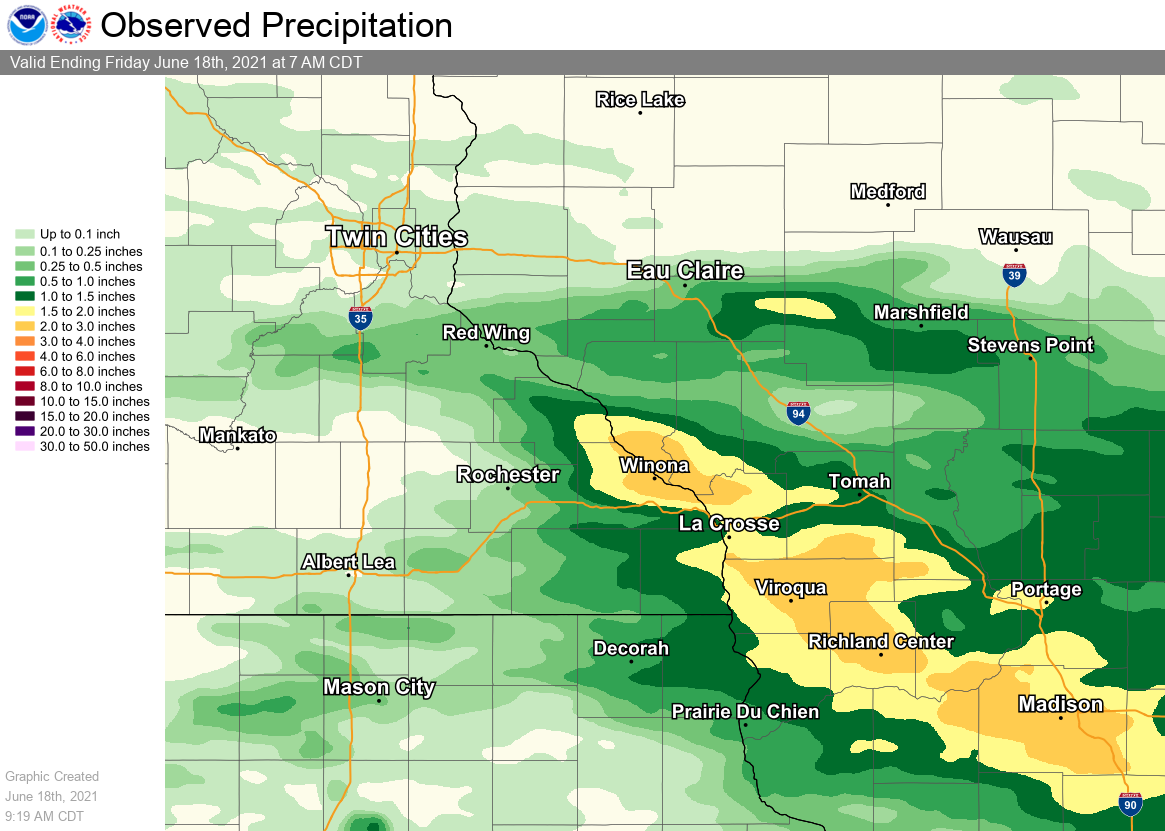
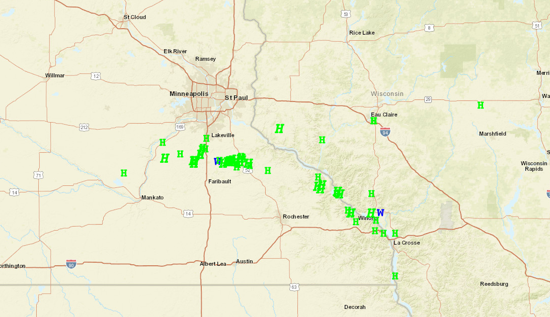
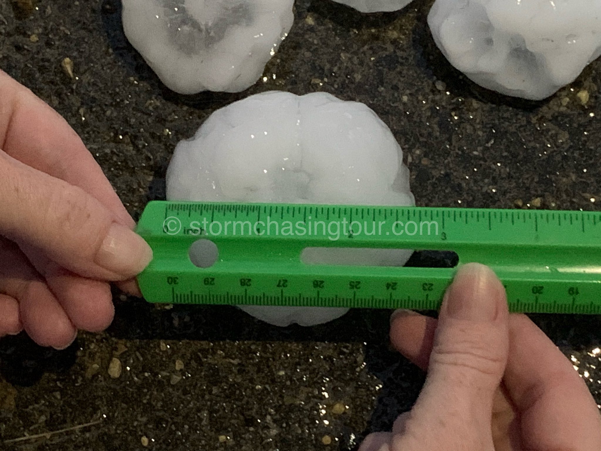
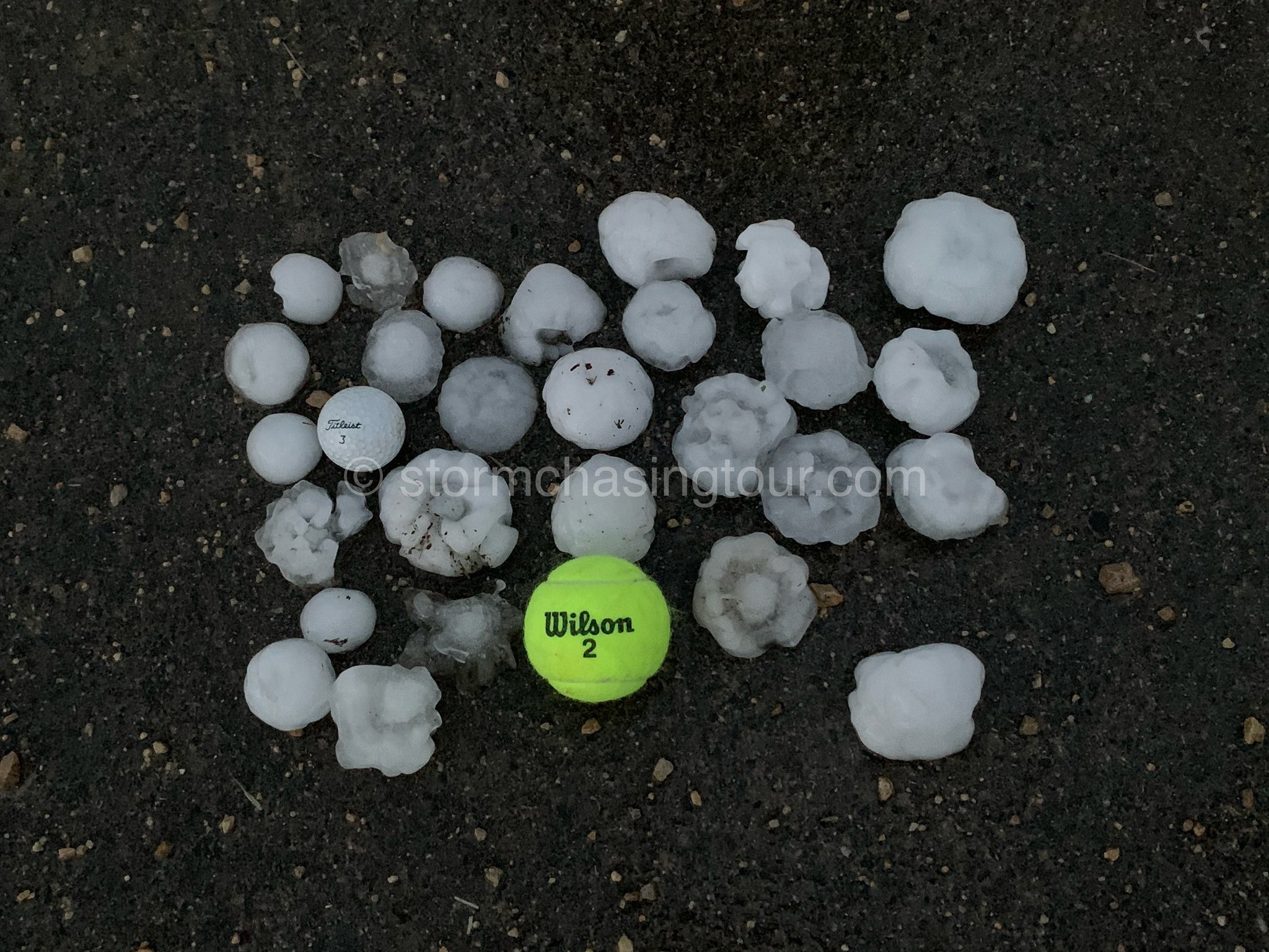
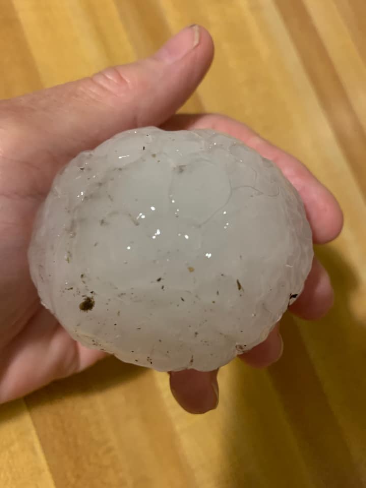
A complex thunderstorms brought severe weather and beneficial rainfall to portions of the Upper Mississippi River Valley and southwest Wisconsin on the evening on June 17, 2021. Two supercells in particular produced destructive hailstones up to the size of baseballs along a path from Le Sueur County in south central Minnesota eastward to Wabasha and Winona counties along the Mississippi River. Rainfall amounts were generally in the 1-3 inch range with a few higher amounts. Due to the very dry conditions present in the area, little in the way of flooding impacts were reported. |
.jpg) Very large hail in Buffalo City - Photo by Dave Timmons |
 |
 |
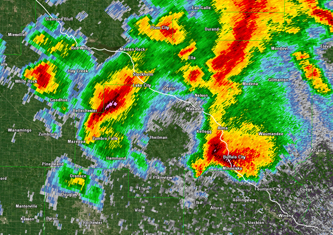 |
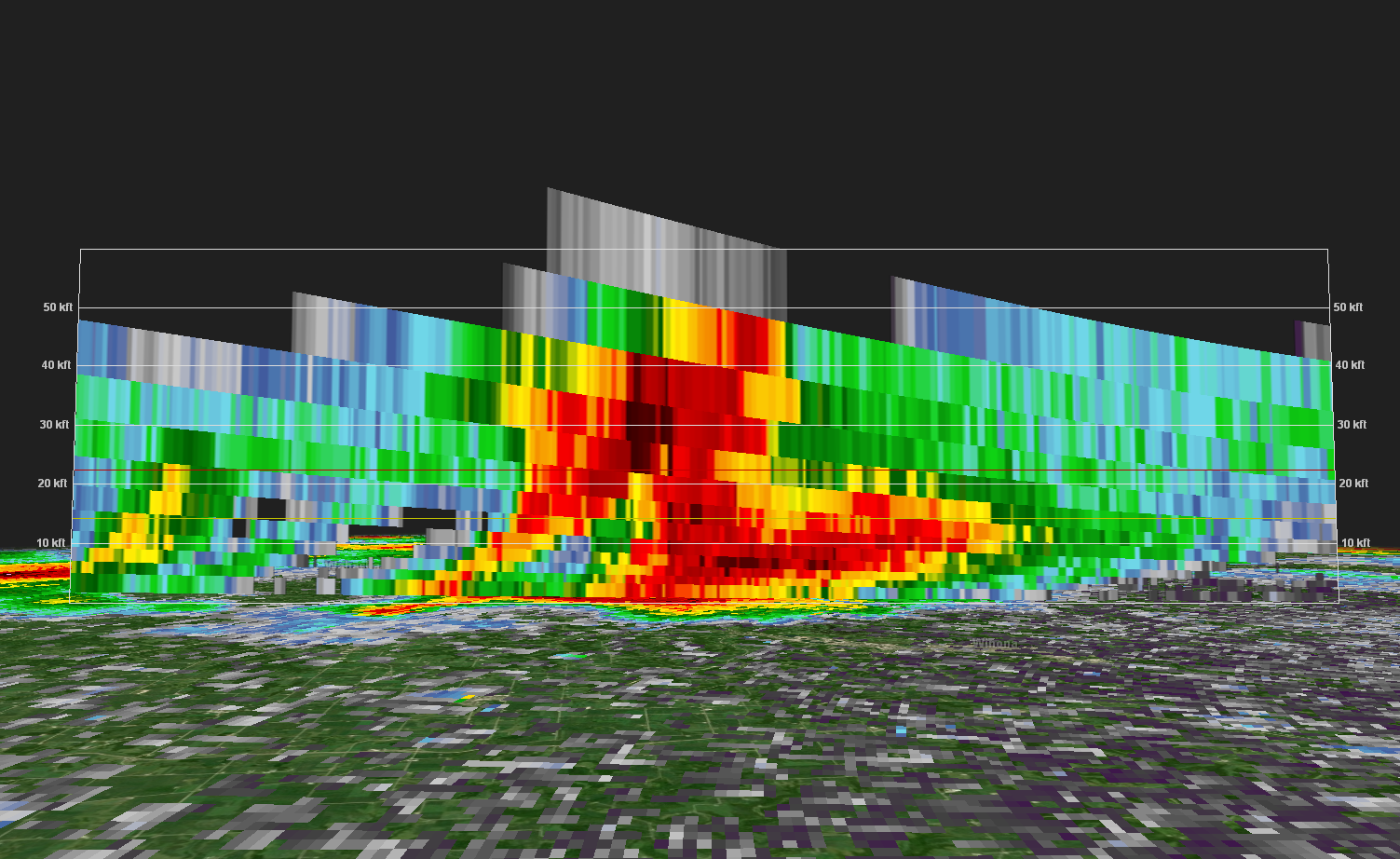
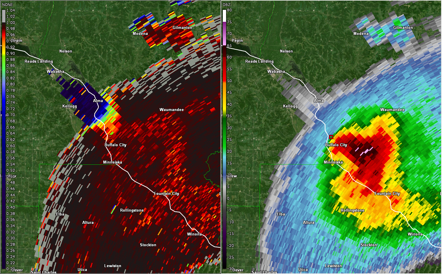
| Rainfall Map from June 17 | Hail reports from the evening storms (view interactive map) | Radar imagery shows the two back-to-back supercells |
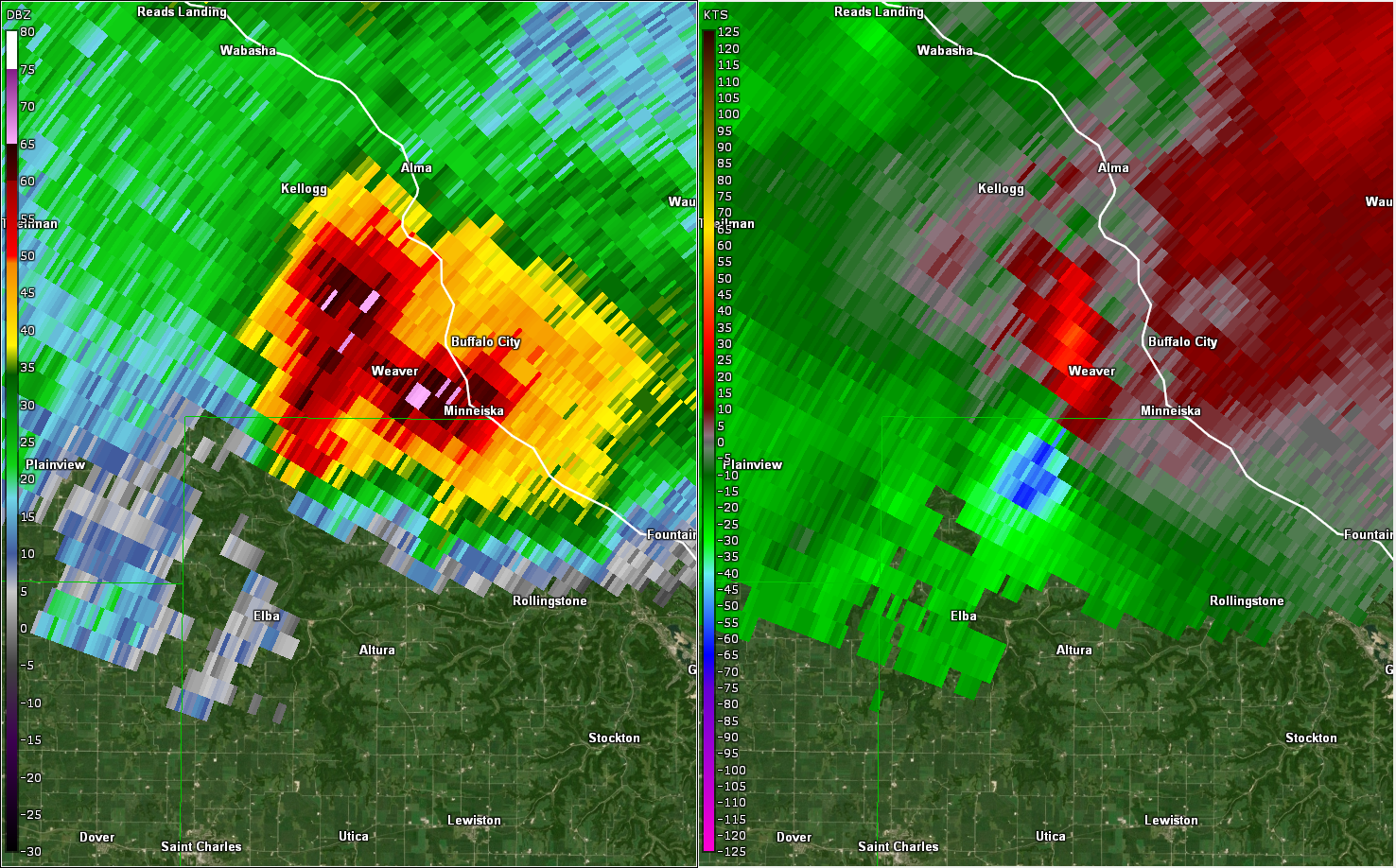
Large Hail - Radar Imagery and Photos:
 |
 |
 |
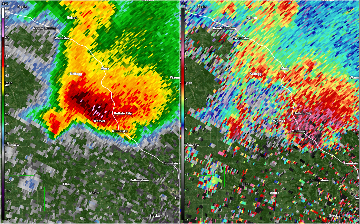 |
| A strongly rotating updraft, known as a mesocyclone (right panel above), was present in the mid-levels of the storm where hail production was maximized. | A cross section through the supercell updraft shows an area of lower reflectivity surrounded by higher values. This is a bounded weak echo region (BWER) and denotes a very strong updraft punching through the storm core. | A three body scatter spike (TBSS) was present from the surface all the way up to 40,000 ft in the storm. This feature shows up as very low correlation coefficient values (blue spike on left panel) down-radial of the storm. | At the surface, differential reflectivity (ZDR) in the areas of higher reflectivity showed a pronounced dropoff to around 0 dB (grey area in right panel). This denotes the presence of large hail, whereas rain would show up as higher values. |
 |
 |
 |
 |
| Hail to the size of baseballs that fell near Kellogg, MN. (Brandon Ivey) | A collection of large hail stones that fell near Kellogg, MN. (Brandon Ivey) | Hail compared to a playing card, Buffalo City, WI. (Marie Livingston) | Hail that barely fits in one's palm that fell in Kellogg, MN. (Mary Bambenek) |
Rain Reports
LOCATION                     AMOUNT    TIME/DATE       LAT/LON

...IOWA...

...ALLAMAKEE COUNTY...
LANSING                      2.00 IN   0640 AM 06/18   43.36N/91.22W
LANSING 4.1 NW               1.55 IN   0700 AM 06/18   43.40N/91.29W
2 SW HARPERS FERRY           1.50 IN   0641 AM 06/18   43.18N/91.17W
WAUKON 0.8 S                 1.22 IN   0635 AM 06/18   43.26N/91.47W
MONONA 9.8 N                 0.89 IN   0700 AM 06/18   43.19N/91.35W
HARPERS FERRY 6.4 SSW        0.86 IN   0700 AM 06/18   43.11N/91.20W
3 SE WATERVILLE              0.80 IN   0907 AM 06/18   43.17N/91.24W
3 S DORCHESTER               0.57 IN   0900 AM 06/18   43.42N/91.51W
POSTVILLE 5.5 NE             0.44 IN   0700 AM 06/18   43.14N/91.49W
5 SW WAUKON JCT              0.21 IN   0845 AM 06/18   43.11N/91.27W

...CHICKASAW COUNTY...
JERICO 2.8 WSW               0.05 IN   0600 AM 06/18   43.17N/92.31W
IONIA 2W                     0.03 IN   0700 AM 06/18   43.03N/92.50W

...CLAYTON COUNTY...
MCGREGOR                     0.76 IN   0948 AM 06/18   43.02N/91.19W
1 WSW MARQUETTE              0.40 IN   0900 AM 06/18   43.04N/91.21W
MONONA                       0.27 IN   0949 AM 06/18   43.04N/91.39W
GUTTENBERG DAM 10            0.24 IN   0600 AM 06/18   42.79N/91.10W
GARBER                       0.18 IN   0915 AM 06/18   42.74N/91.26W
LITTLEPORT                   0.14 IN   0945 AM 06/18   42.75N/91.37W
ELKADER 6SSW                 0.05 IN   0700 AM 06/18   42.78N/91.45W
BIG SPRING FISH HATCHERY     0.02 IN   0900 AM 06/18   42.91N/91.47W

...FAYETTE COUNTY...
ELDORADO 1E - TURKEY RIVER   0.11 IN   0945 AM 06/18   43.05N/91.81W
FAYETTE                       T IN     0740 AM 06/18   42.88N/91.83W
WAUCOMA 3.2 S                 T IN     0700 AM 06/18   43.01N/92.03W

...FLOYD COUNTY...
NORA SPRINGS 2.4 SSE         0.06 IN   0700 AM 06/18   43.11N/92.99W
CHARLES CITY                 0.01 IN   0930 AM 06/18   43.06N/92.67W

...HOWARD COUNTY...
2 N CRESCO                   0.20 IN   0654 AM 06/18   43.40N/92.12W
3 E ELMA                     0.12 IN   0945 AM 06/18   43.25N/92.38W
ELMA                         0.08 IN   0700 AM 06/18   43.24N/92.44W
RICEVILLE                    0.03 IN   0947 AM 06/18   43.36N/92.48W
SARATOGA                     0.02 IN   0946 AM 06/18   43.35N/92.42W

...MITCHELL COUNTY...
OSAGE 4.7 E                  0.07 IN   0700 AM 06/18   43.28N/92.72W
ST ANSGAR                    0.06 IN   0630 AM 06/18   43.38N/92.92W
OSAGE                        0.05 IN   0700 AM 06/18   43.28N/92.81W

...WINNESHIEK COUNTY...
DECORAH 4.9SE                1.12 IN   0700 AM 06/18   43.26N/91.70W
7 ENE DECORAH                0.65 IN   0813 AM 06/18   43.34N/91.64W
DECORAH                      0.24 IN   0845 AM 06/18   43.30N/91.80W
SPILLVILLE                   0.19 IN   0930 AM 06/18   43.21N/91.95W
1 ENE JACKSON JUNCTION       0.14 IN   0950 AM 06/18   43.11N/92.04W
1 ENE BLUFFTON               0.10 IN   0845 AM 06/18   43.41N/91.90W

...MINNESOTA...

...DODGE COUNTY...
CLAREMONT 2.5 ESE            0.01 IN   0800 AM 06/18   44.04N/92.95W
HAYFIELD 0.3 SSE             0.01 IN   0630 AM 06/18   43.89N/92.85W

...FILLMORE COUNTY...
CHATFIELD 9.0 ESE            0.65 IN   0700 AM 06/18   43.79N/92.03W
PRESTON                      0.48 IN   0700 AM 06/18   43.67N/92.07W
CHATFIELD 0.7 SW             0.38 IN   0700 AM 06/18   43.84N/92.20W
PRESTON 3.2 NNE              0.34 IN   0600 AM 06/18   43.71N/92.05W
1 NNW FILLMORE               0.31 IN   0930 AM 06/18   43.76N/92.27W
LANESBORO                    0.26 IN   0930 AM 06/18   43.72N/91.98W
MABEL                        0.20 IN   0700 AM 06/18   43.52N/91.76W
WYKOFF 3.1 NW                0.17 IN   0700 AM 06/18   43.74N/92.31W
SPRING VALLEY                0.07 IN   0700 AM 06/18   43.69N/92.39W

...HOUSTON COUNTY...
HOUSTON 6.9 E                1.81 IN   0730 AM 06/18   43.76N/91.43W
3 SSW FREEBURG               1.50 IN   0618 AM 06/18   43.57N/91.39W
MOUND PRAIRIE                1.41 IN   0845 AM 06/18   43.78N/91.45W
LA CRESCENT 5.4 SW           1.27 IN   0700 AM 06/18   43.78N/91.39W
LA CRESCENT 0.7 N            1.09 IN   0730 AM 06/18   43.84N/91.30W
LA CRESCENT 1.0 WSW          1.02 IN   0700 AM 06/18   43.83N/91.32W
HOUSTON                      1.01 IN   0948 AM 06/18   43.77N/91.58W
1 W LA CRESCENT              1.01 IN   0851 AM 06/18   43.83N/91.32W
HOKAH 4 NW                   0.92 IN   0700 AM 06/18   43.80N/91.43W
CALEDONIA                    0.76 IN   0700 AM 06/18   43.63N/91.50W
MABEL 2.7 E                  0.25 IN   0800 AM 06/18   43.51N/91.71W
4 SSE MOUND PRAIRIE          0.02 IN   0945 AM 06/18   43.72N/91.44W

...MOWER COUNTY...
AUSTIN 1.9 ENE               0.13 IN   0800 AM 06/18   43.68N/92.94W
AUSTIN 3 NW - TURTLE CREEK   0.10 IN   0930 AM 06/18   43.65N/92.98W
OSTRANDER 5.1 WNW            0.08 IN   0700 AM 06/18   43.65N/92.52W
AUSTIN 2.4 W                 0.06 IN   0700 AM 06/18   43.67N/93.02W
LANSING - CEDAR RIVER        0.05 IN   0930 AM 06/18   43.75N/92.96W
AUSTIN 1.5 WSW               0.04 IN   0700 AM 06/18   43.67N/93.00W
DOBBINS CREEK                0.03 IN   0930 AM 06/18   43.68N/92.94W
AUSTIN WASTE WATER TREATMENT 0.02 IN   0700 AM 06/18   43.65N/92.97W

...OLMSTED COUNTY...
SAINT CHARLES 7.6 NNW        0.50 IN   0623 AM 06/18   44.08N/92.10W
ROCHESTER                    0.29 IN   0943 AM 06/18   44.04N/92.44W
1 W CHESTER                  0.22 IN   0630 AM 06/18   44.00N/92.38W
ROCHESTER                    0.19 IN   0947 AM 06/18   44.18N/92.41W
ELBA 4.7 SW                  0.19 IN   0800 AM 06/18   44.04N/92.09W
ROCHESTER-BELTLINE BEAR CREE 0.13 IN   0930 AM 06/18   44.01N/92.45W
ROCHESTER 4.7 ENE            0.13 IN   0800 AM 06/18   44.04N/92.39W
ROCHESTER                    0.12 IN   0943 AM 06/18   44.01N/92.49W
ELGIN 2SSW                   0.10 IN   0700 AM 06/18   44.10N/92.27W
ROCHESTER 4.1 ENE            0.09 IN   0830 AM 06/18   44.04N/92.40W
3 ENE ROCHESTER              0.08 IN   0930 AM 06/18   44.03N/92.43W
5 WSW ROCHESTER              0.08 IN   0900 AM 06/18   43.98N/92.56W
3 W ROCHESTER                0.07 IN   0930 AM 06/18   44.02N/92.53W
ROCHESTER 3.3 ENE            0.07 IN   0800 AM 06/18   44.04N/92.42W
MAYO HELIPAD                 0.06 IN   0935 AM 06/18   44.02N/92.48W
ROCHESTER INTERNATIONAL AIRP 0.05 IN   0854 AM 06/18   43.90N/92.50W
ROCHESTER-CASCADE CREEK      0.04 IN   0930 AM 06/18   44.03N/92.47W
1 W ORONOCO                  0.04 IN   0930 AM 06/18   44.17N/92.55W
ROCHESTER 2.0 NNE            0.04 IN   0700 AM 06/18   44.04N/92.47W
2 NE ROCHESTER               0.04 IN   0600 AM 06/18   44.04N/92.44W
2 W HIGH FOREST              0.03 IN   0700 AM 06/18   43.85N/92.59W
ALTURA                       0.01 IN   0950 AM 06/18   44.13N/92.58W
ROCHESTER                    0.01 IN   0945 AM 06/18   44.05N/92.45W
6 NNW GENOA                  0.01 IN   0900 AM 06/18   44.19N/92.65W
ROCHESTER 4.2 N              0.01 IN   0600 AM 06/18   44.08N/92.49W
2 NNW ROCHESTER               T IN     0600 AM 06/18   44.05N/92.49W

...WABASHA COUNTY...
1 N KELLOGG                  1.78 IN   0900 AM 06/18   44.32N/92.00W
WABASHA                      1.57 IN   0948 AM 06/18   44.30N/92.00W
2 ESE WABASHA                1.09 IN   0637 AM 06/18   44.36N/92.02W
THEILMAN 1 SSW               1.03 IN   0730 AM 06/18   44.28N/92.19W
PLAINVIEW                    0.91 IN   0942 AM 06/18   44.17N/92.17W
1 N WABASHA                  0.70 IN   0711 AM 06/18   44.38N/92.04W
0.9 N WABASHA                0.50 IN   0700 AM 06/18   44.38N/92.05W
LAKE CITY 0.1 E              0.47 IN   0700 AM 06/18   44.44N/92.28W
LAKE CITY                    0.43 IN   0945 AM 06/18   44.44N/92.28W
PLAINVIEW                    0.23 IN   0949 AM 06/18   44.16N/92.17W
ZUMBRO FALLS 3.5 SSW         0.20 IN   0600 AM 06/18   44.24N/92.46W
3 ESE MAZEPPA                0.09 IN   0930 AM 06/18   44.26N/92.49W
1 SSE KELLOGG                0.02 IN   0945 AM 06/18   44.28N/91.99W

...WINONA COUNTY...
MINNESOTA CITY 1.1 SE        2.78 IN   0700 AM 06/18   44.08N/91.73W
SUGAR LOAF/WINONA            2.74 IN   0700 AM 06/18
1 ESE WINONA                 2.61 IN   0945 AM 06/18   44.04N/91.63W
WINONA DAM 5A                2.60 IN   0800 AM 06/18   44.09N/91.67W
WINONA 2.0 ESE               2.60 IN   0700 AM 06/18   44.04N/91.63W
4.2 N ROLLINGSTONE           2.60 IN   0700 AM 06/18   44.16N/91.81W
WINONA 1.9 ESE               2.53 IN   0650 AM 06/18   44.04N/91.63W
MINNEISKA                    2.50 IN   0530 AM 06/18   44.19N/91.87W
WINONA 1.3 SSW               2.45 IN   0700 AM 06/18   44.03N/91.68W
WINONA 12.0 ESE              2.44 IN   0700 AM 06/18   43.99N/91.44W
WINONA MUNICIPAL AIRPORT     2.25 IN   0935 AM 06/18   44.07N/91.70W
STOCKTON                     1.98 IN   0622 AM 06/18   44.03N/91.77W
STOCKTON 1.2 W               1.93 IN   0553 AM 06/18   44.03N/91.79W
BEAVER                       1.81 IN   0845 AM 06/18   44.15N/92.00W
4 SW WINONA                  1.79 IN   0700 AM 06/18
LA CRESCENT DAM 7            1.50 IN   0800 AM 06/18   43.87N/91.31W
3 NE NODINE                  1.46 IN   0930 AM 06/18   43.94N/91.41W
LEWISTON 0.2 NW              1.35 IN   0700 AM 06/18   43.99N/91.87W
1 WSW ELBA                   1.07 IN   0945 AM 06/18   44.09N/92.03W
WHITEWATER STATE PARK        0.96 IN   0930 AM 06/18   44.05N/92.05W
3 SW ELBA                    0.76 IN   0930 AM 06/18   44.06N/92.05W
SAINT CHARLES                0.38 IN   0950 AM 06/18   43.97N/92.06W
DAKOTA                       0.28 IN   0915 AM 06/18   43.91N/91.36W

...WISCONSIN...

...ADAMS COUNTY...
OXFORD 4.6 WNW               0.98 IN   0600 AM 06/18   43.81N/89.65W
NEKOOSA 8.0 SSE              0.92 IN   0700 AM 06/18   44.21N/89.85W
OXFORD 4.0 W                 0.77 IN   0700 AM 06/18   43.79N/89.64W
0.6 W FRIENDSHIP             0.62 IN   0700 AM 06/18   43.98N/89.83W
FRIENDSHIP 6.4 NNE           0.62 IN   0700 AM 06/18   44.06N/89.79W
GRAND MARSH 1.0 W            0.54 IN   0700 AM 06/18   43.89N/89.73W

...BUFFALO COUNTY...
MONDOVI 12.1 SSE             0.32 IN   0619 AM 06/18   44.40N/91.60W
DODGE                        0.01 IN   0945 AM 06/18   44.13N/91.55W

...CLARK COUNTY...
1 NE SIDNEY                  1.50 IN   0939 AM 06/18   44.56N/90.63W

...CRAWFORD COUNTY...
3 SW SOLDIERS GROVE          2.10 IN   0915 AM 06/18   43.36N/90.81W
SOLDIERS GROVE               2.00 IN   0640 AM 06/18   43.40N/90.77W
GAYS MILLS 1.0 NE            1.95 IN   0700 AM 06/18   43.33N/90.84W
1 S DE SOTO                  1.37 IN   0535 AM 06/18   43.41N/91.19W
STEUBEN                      1.01 IN   0945 AM 06/18   43.18N/90.86W
STEUBEN 4SE                  1.01 IN   0700 AM 06/18   43.13N/90.84W
EASTMAN                      1.00 IN   0541 AM 06/18   43.17N/91.02W
DE SOTO                      0.98 IN   0946 AM 06/18   43.42N/91.19W
2.8 E HARPERS FERRY          0.90 IN   0800 AM 06/18   43.21N/91.10W
EASTMAN 2.4 NNE              0.79 IN   0645 AM 06/18   43.20N/91.00W
PRAIRIE DU CHIEN 1.4 N       0.55 IN   0700 AM 06/18   43.06N/91.14W
PRAIRIE DU CHIEN  AIRPORT    0.54 IN   0755 AM 06/18   43.02N/91.12W
0.6 NE PRAIRIE DU CHIEN      0.46 IN   0700 AM 06/18   43.05N/91.13W

...GRANT COUNTY...
MUSCODA 0.5 WSW              1.40 IN   0839 AM 06/18   43.18N/90.44W
BOSCOBEL                     1.34 IN   0903 AM 06/18   43.15N/90.68W
BOSCOBEL AIRPORT             1.30 IN   0853 AM 06/18   43.15N/90.68W
FENNIMORE                    0.88 IN   0950 AM 06/18   42.98N/90.66W
LANCASTER                    0.78 IN   0941 AM 06/18   42.83N/90.69W
4.3 W LANCASTER              0.76 IN   0800 AM 06/18   42.83N/90.79W
BLOOMINGTON                  0.70 IN   0638 AM 06/18   42.89N/90.92W
BLOOMINGTON 3.5 N            0.55 IN   0643 AM 06/18   42.94N/90.92W
PATCH GROVE 0.1 NNW          0.43 IN   0700 AM 06/18   42.94N/90.97W
PLATTEVILLE                  0.40 IN   0947 AM 06/18   42.74N/90.46W
CASSVILLE 7.8 ENE            0.28 IN   0700 AM 06/18   42.75N/90.84W
PLATTEVILLE 0.3 NE           0.17 IN   0700 AM 06/18   42.74N/90.47W
PLATTEVILLE MUNICIPAL AIRPOR 0.07 IN   0935 AM 06/18   42.68N/90.43W
MUSCODA                      0.01 IN   0946 AM 06/18   43.19N/90.46W

...JACKSON COUNTY...
MELROSE 3.6 W                1.28 IN   0700 AM 06/18   44.13N/91.07W
HIXTON                       0.50 IN   0944 AM 06/18   44.39N/91.01W
MATHER 3NW                   0.44 IN   0700 AM 06/18   44.17N/90.35W
BLACK RIVER FALLS AREA AIRPO 0.17 IN   0935 AM 06/18   44.25N/90.85W
BLACK RIVER FALLS            0.12 IN   0830 AM 06/18   44.29N/90.85W
BLACK RIVER FALLS 1.7 NNE    0.11 IN   0700 AM 06/18   44.32N/90.83W
1 E BLACK RIVER FALLS        0.01 IN   0915 AM 06/18   44.30N/90.73W

...JUNEAU COUNTY...
NEW LISBON                   0.91 IN   0916 AM 06/18   43.87N/90.17W
MAUSTON                      0.85 IN   0947 AM 06/18   43.80N/90.07W
3 ESE LEMONWEIR              0.79 IN   0530 AM 06/18   43.77N/89.96W
NECEDAH NWR RY DAM NECEDAH 5 0.68 IN   0910 AM 06/18   44.06N/90.17W
NECEDAH                      0.62 IN   0848 AM 06/18   44.03N/90.08W
MAUSTON AIRPORT              0.61 IN   0935 AM 06/18   43.83N/90.13W
0.6 W NECEDAH                0.37 IN   0748 AM 06/18   44.02N/90.08W
VOLK FIELD                   0.29 IN   0856 AM 06/18   43.92N/90.27W

...LA CROSSE COUNTY...
5 NNE STODDARD               2.75 IN   0532 AM 06/18   43.73N/91.20W
LA CROSSE 5.4 SE             2.06 IN   0800 AM 06/18   43.77N/91.17W
LA CROSSE 4.4 SSE            1.95 IN   0700 AM 06/18   43.77N/91.21W
ONALASKA 2N                  1.93 IN   0700 AM 06/18   43.91N/91.23W
HOLMEN 1.7 SSE               1.83 IN   0700 AM 06/18   43.93N/91.24W
HOLMEN 2 S                   1.83 IN   0700 AM 06/18   43.93N/91.25W
COON VALLEY 4.5 NNW          1.68 IN   0700 AM 06/18   43.76N/91.06W
LA CROSSE 4NNW               1.51 IN   0730 AM 06/18   43.87N/91.27W
LA CROSSE REGIONAL AIRPORT   1.48 IN   0853 AM 06/18   43.88N/91.25W
ONALASKA 0.6 SW              1.47 IN   0700 AM 06/18   43.88N/91.23W
LA CROSSE                    1.45 IN   0908 AM 06/18   43.82N/91.19W
MINDORO 6.6 E                1.13 IN   0800 AM 06/18   44.04N/90.97W

...MONROE COUNTY...
WILTON 4.2 E                 1.40 IN   0700 AM 06/18   43.81N/90.44W
KENDALL                      1.30 IN   0930 AM 06/18   43.79N/90.37W
SPARTA 0.6 NW                1.00 IN   0715 AM 06/18   43.95N/90.82W
3 WNW OAKDALE                0.99 IN   0849 AM 06/18   43.97N/90.44W
0.5 SW SPARTA                0.96 IN   0800 AM 06/18   43.94N/90.82W
WARRENS 4.7 WSW              0.80 IN   0700 AM 06/18   44.10N/90.59W
2 E CATARACT                 0.68 IN   0948 AM 06/18   44.09N/90.79W
SPARTA/FORT MCCOY AIRPORT    0.01 IN   0935 AM 06/18   43.97N/90.73W

...RICHLAND COUNTY...
RICHLAND CENTER              2.65 IN   0533 AM 06/18   43.34N/90.38W
1 SSE RICHLAND CENTER        1.79 IN   0949 AM 06/18   43.32N/90.38W
RICHLAND CENTER 4.0 N        1.58 IN   0800 AM 06/18   43.40N/90.39W
RICHLAND CENTER 4 N          1.58 IN   0700 AM 06/18   43.40N/90.39W

...TREMPEALEAU COUNTY...
TREMPEALEAU 7.6 NNW          3.14 IN   0700 AM 06/18   44.11N/91.48W
GALESVILLE 1.0 NE            2.95 IN   0600 AM 06/18   44.10N/91.34W
GALESVILLE 2WSW              2.87 IN   0600 AM 06/18   44.07N/91.39W
TREMPEALEAU DAM 6            2.60 IN   0800 AM 06/18   44.00N/91.44W
GALESVILLE 4.7 E             2.19 IN   0646 AM 06/18   44.08N/91.26W
TREMPEALEAU                  2.13 IN   0947 AM 06/18   44.07N/91.51W
1 NW TREMPEALEAU             2.13 IN   0600 AM 06/18   44.03N/91.46W
2 N TREMPEALEAU              2.00 IN   0617 AM 06/18   44.04N/91.43W
ETTRICK 4.0 WNW              1.75 IN   0745 AM 06/18   44.19N/91.34W
ETTRICK                      1.50 IN   0523 AM 06/18   44.17N/91.27W
OSSEO 0.4 E                  1.08 IN   0600 AM 06/18   44.58N/91.21W

...VERNON COUNTY...
VIROQUA 0.8 ESE              2.28 IN   0700 AM 06/18   43.55N/90.87W
LA FARGE                     2.18 IN   0946 AM 06/18   43.60N/90.63W
COON VALLEY 0.1 WSW          2.18 IN   0800 AM 06/18   43.70N/91.01W
1 N VIROQUA                  2.00 IN   0530 AM 06/18   43.57N/90.89W
ONTARIO                      1.70 IN   0845 AM 06/18   43.72N/90.59W
HILLSBORO 0.5 WSW            1.61 IN   0700 AM 06/18   43.65N/90.35W
HILLSBORO 2 SW               1.52 IN   0700 AM 06/18   43.63N/90.38W
3 N VICTORY                  1.33 IN   0943 AM 06/18   43.53N/91.22W
GENOA DAM 8                  1.30 IN   0600 AM 06/18   43.57N/91.23W

OBSERVATIONS ARE COLLECTED FROM A VARIETY OF SOURCES WITH VARYING
EQUIPMENT AND EXPOSURES. WE THANK ALL VOLUNTEER WEATHER OBSERVERS
FOR THEIR DEDICATION. NOT ALL DATA LISTED ARE CONSIDERED OFFICIAL.
 |
Media use of NWS Web News Stories is encouraged! Please acknowledge the NWS as the source of any news information accessed from this site. |
|


 Weather Story
 Weather Map
 Local Radar