Overview
|
Low pressure dropped through the Driftless Region during the afternoon hours of June 17, 2026. This system, combined with strong wind shear and a narrow axis of moisture and instability, produced a cluster of thunderstorms over southeast Minnesota that then spread into northeast Iowa. One rotating storm quickly intensified as it moved through Allamakee County, Iowa with a radar confirmed tornado developing about 5 miles east of Waukon. |
 Radar from 4:47pm through 6:02pm CDT on June 17, 2026 showing a tornado-warned storm passing from Allamakee County through Grant County. |
Tornadoes
Select a tornado from the table to zoom into the track and view more information. The default table view is limited to 8 tracks, but can be scrolled by a mouse wheel or dynamically expanded. Additionally, the table can fill the entire window by clicking the small circular expanding arrow icon at the very top right of the table and returned to its original size by clicking the button again. The side information panel that opens over the map can be closed using the "X" on the upper right corner of the pop-up. Zoom into the map and click damage points to see detailed information and pictures from the surveys.
|
NOTE: times shown below are local to your device's time zone. |

The Enhanced Fujita (EF) Scale classifies tornadoes into the following categories:
| EF0 Weak 65-85 mph |
EF1 Moderate 86-110 mph |
EF2 Significant 111-135 mph |
EF3 Severe 136-165 mph |
EF4 Extreme 166-200 mph |
EF5 Catastrophic 200+ mph |
 |
|||||
| Tornadoes that fail to impact any ratable damage indicators on the EF-Scale are rated EF-Unknown (EF-U) | |||||
Photos & Video
 |
 |
 |
 |
| North of Harpers Ferry, IA (Darcy Manske) |
North of Harpers Ferry, IA (Darcy Manske) |
South of Lynxville, IA (Dessa Caya) |
North of Waterville, IA (Kerri Gibbs) |
 |
 |
 |
 |
| North of Harpers Ferry, IA (Mark Johnson) |
North of Waterville, IA (Sarah Collins) |
Near Elon, IA (NWS Storm Survey) |
Near Elon, IA (NWS Storm Survey) |
 |
 |
 |
 |
| Near Elon, IA (NWS Storm Survey) |
North of Harpers Ferry, IA (NWS Storm Survey) |
Northeast of Waterville, IA (NWS Storm Survey) |
North of Eastman, WI (NWS Storm Survey) |
 |
 |
 |
 |
| North of Eastman, WI (NWS Storm Survey) |
North of Eastman, WI (Jessica Kasinskas) |
Castle Rock Twp (Grant Co), WI (Kristine Nelson Washburn) |
Castle Rock Twp (Grant Co), WI (NWS Storm Survey) |
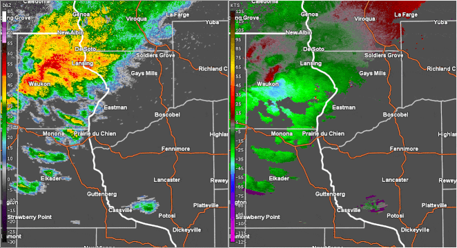
Radar
 |
 |
 |
 |
| Radar at 4:50pm CDT when the first tornado warning was issued for east-central Allamakee County, Iowa. | Radar at 4:58pm CDT as a well-defined tornado debris signature (TDS) became evident north of Waterville, Iowa. | Radar correlation coefficient at 5:07pm CDT, showing debris being lofted in excess of 15,000 ft AGL north of Harpers Ferry, Iowa. | Radar at 517pm CDT as the tornado crossed Highway 27 between Seneca and Eastman, WI in Crawford County, still with a TDS. |
NWS La Crosse Service
 |
 |
 |
 |
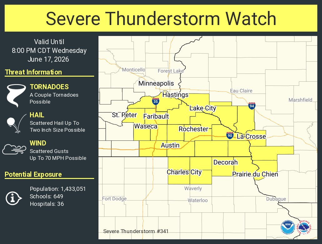
| Morning Weather Story Graphic Issued 8am CDT 6/17/2026. | SPC Mesoscale Discussion Issued 12:39pm CDT 6/17/2026. | Severe Thunderstorm Watch Issued 1:16pm CDT 6/17/2026. | Nowcast Graphic Issued 1:53pm CDT 6/17/2026. |
 |
 |
 |
 |
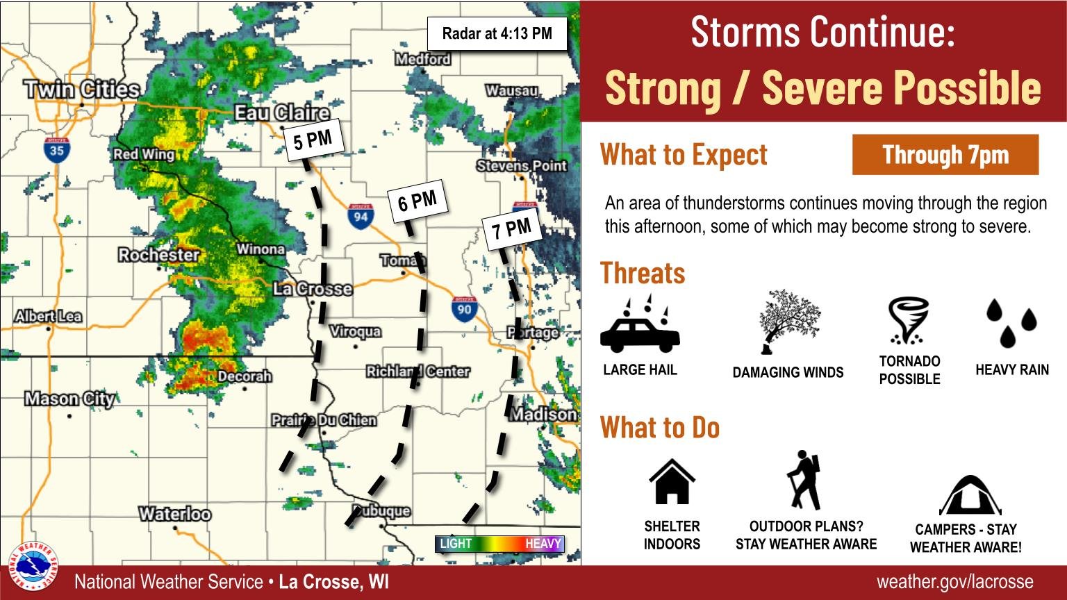
| Nowcast Graphic Issued 4:15pm CDT 6/17/2026. |
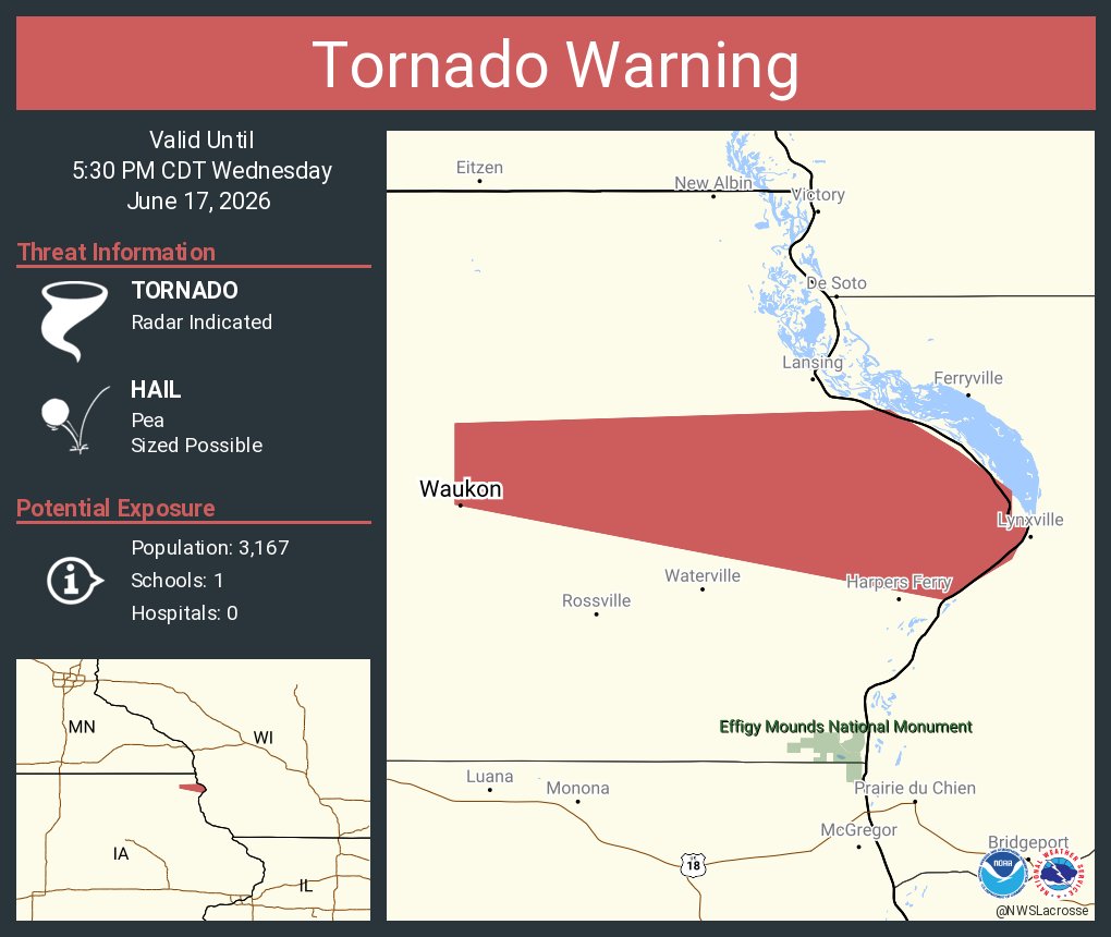
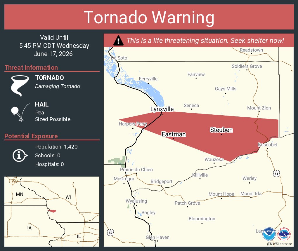
Tornado Warning for Allamakee County Issued 4:50pm CDT. | Tornado Warning for Crawford County Issued 5:04pm CDT. | Tornado Warning for Grant County Issued 5:33pm CDT. |
 |
Media use of NWS Web News Stories is encouraged! Please acknowledge the NWS as the source of any news information accessed from this site. |
|


 Weather Story
 Weather Map
 Local Radar