Upper Mississippi River Weather Summary for June 2026:
Temperatures - Near Normal
- During June 2026, average temperatures ranged from 63.6°F near Owen, WI (COOP) to 70°F at Charles City, IA (COOP).
- Temperature anomalies were near normal.
- The hottest temperature was 95°F on June 29 at Sparta Fort McCoy, WI (ASOS) and Friendship, WI (COOP) the coldest temperature was 37°F on June 3 near Hillsboro, WI (COOP).
|
 |
Precipitation - Drier than Normal
- Rainfall amounts ranged from 2.06" at Friendship, WI (AWOS) to 11.19" near Dickeyville, WI (CoCoRaHS).
- Rainfall anomalies ranged from 3" drier than normal to 5" wetter than normal.
- The wettest day was June 8-9 when 6.37" of rain near Houston, MN (COOP).
|
.jpg) |
| Seasonal Snowfall - Below to Near-Normal |
|
| |
|
| |
|
- From July 1, 2024 through June 30, 2025, seasonal snow varied from 26.9" near Lancaster, WI (COOP) to 63.5" near Westby, WI (CoCoRaHS).
- Snowfall anomalies ranged from 27" below normal to 18" above normal.
- The snowiest day was March 14-15 when 18" of snow fell near Colby, WI (CoCoRaHS) and Wabasha, MN (CoCoRaHS).
|
.jpg) |
| Severe Weather - Another Active Month |
|
|
Severe Thunderstorm Warnings - 4th Most
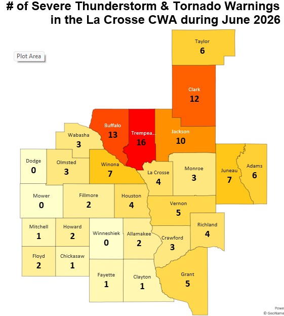
- There were 55 Severe Thunderstorm Warnings issued in June 2026. This was the 4th most in June. The most in June was 110 warnings in 1998. This was the 10th most in a calendar month. The most in an individual month was 110 warnings in June 1998.
|

|
|
Tornado Warnings - 10th Most
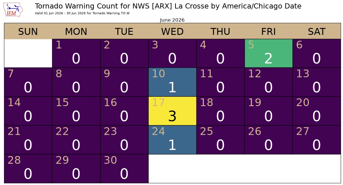
- There were 7 Tornado Warnings issued in June 2026. This was the 10th most in June. The most was 28 in 1998.
|
 |
|
Daily Breakdown of Severe Weather in June 2026 - 8 days
- June 10 - 31 warnings (30 severe thunderstorm & 1 tornado)
- June 24 - 9 warnings (8 severe thunderstorm & 1 tornado)
- June 5 - 9 warnings (7 severe thunderstorm & 2 tornado)
- June 19 - 5 warnings (5 severe thunderstorm)
- June 17 - 3 warnings (3 tornado)
- June 30 - 2 warnings (2 severe thunderstorm)
- June 11 - 2 warnings (2 severe thunderstorm)
- June 28 - 1 warning (1 severe thunderstorm)
|
 |
Below are the June 2026 climate summaries for La Crosse, WI, and Rochester, MN.
La Crosse, WI
June 2026 was Slightly Cooler and Drier than Normal for La Crosse, WI
...June 2026 Highlights...
Temperatures - Slightly Cooler than Normal
- During June 2026, the average temperature at La Crosse Regional Airport was 69.8°F.
- This was 1.2°F cooler than the 1991-2020 normal of 71°F.
- The average high temperature was 79.8°F. This was 1.9°F cooler than the 1991-2020 normal of 81.7°F.
- The average low temperature was 59.7°F. This was 0.7°F cooler than the 1991-2020 normal of 60.4°F.
- The warmest high temperature was 94°F on June 29.
- The coldest high temperature was 65°F on June 17.
- The warmest low temperature was 81°F on June 30.
- The coldest low temperature was 50°F on June 19 and June 23.
Precipitation - Slightly Drier than Normal
- A total of 4.94" of rain fell at La Crosse Regional Airport.
- This was 0.14" drier than the 1991-2020 normal of 5.08".
- The wettest day occurred on June 8 when 1.33" of rain fell.
- Measurable rain fell on 13 days (43.3%) and a trace of rain fell on another 2 days (6.7%).
Seasonal Snow - Below Normal
- From July 1, 2025 through June 30, 2026, the snow observer near La Crosse Regional Airport measured 40" of snow. This was 6.3" below the 1991-2020 normal of 46.3".
- The snowiest calendar day was 7.2" on March 15.
- Measurable snow fell on 26 days (7.1%) and a trace fell on another 29 days (7.9%).
- Here is a break down of the daily snowfalls.
No Snow 310 days (84.9%)
Trace 29 days ( 7.9%)
0.1 to 0.9 inches 15 days ( 4.1%)
1.0 to 2.9 inches 7 days ( 1.9%)
3.0 to 5.9 inches 2 days ( 0.5%)
6.0 to 8.9 inches 2 days ( 0.5%)
Mississippi River at La Crosse, WI - Below Normal
- Average June 7 am stage was 5.22 feet.
- This was 1.71 feet below the 1937-2026 average of 6.93 feet.
- The lowest 7 am stage was 4.87 feet on June 5. The lowest 7 am Junestage was 4.02 feet on June 29, 1959.
- The highest 7 am stage was 6.04 feet on June 16. The highest 7 am June stage was 14.42 feet on June 30, 2024.
...June 2026 Records...
Daily Records...
- On June 30, the low temperature at La Crosse Regional Airport was 81°F. This surpassed the previous warm low temperature record for the date of 78°F in 1931.
Monthly Records....
- This low temperature was the warmest June low temperature. The previous record was 80°F on June 29, 1931 and June 22, 2025.
All-Time Records...
- It also tied the warmest low temperature ever recorded in La Crosse. An 81°F low temperature has occurred 4 times (July 21, 1901; July 13, 1995; July 4, 2012; and June 30, 2026).
...Looking ahead to July...
- The normal high temperature in La Crosse is 85.4°F and the normal low temperature is 64.5°F. The normal monthly mean temperature is 75.0°F. La Crosse’s hottest July occurred in 2012 with an average temperature of 79.6°F and their coldest July occurred in 1891 with an average of 66.9°F.
- For July, the hottest temperature was 108°F (also the hottest temperature for any day of the year) on July 14, 1936, and July 13, 1995, and the coldest temperature was 44°F on July 4, 1967. There are typically 7 days with temperatures at or above 90°F.
- The normal precipitation for July is 4.23". The wettest July occurred in 1883 when 11.03" of rain fell and the driest occurred in 1967 when 0.16" of rain fell. The wettest July day was 5.24" on July 27, 1987. Normally, there are 7 days with thunderstorms.
Rochester, MN
June 2026 was Drier and Slightly Warmer than Normal at Rochester, MN
...June 2026 Highlights...
Temperatures - Slightly Warmer than Normal
- The average temperature at Rochester International Airport was 67.6°F.
- This was 0.1°F warmer than the 1991-2020 normal of 67.5°F.
- The average high temperature was 77.3°F. This was 0.3°F cooler than the 1991-2020 normal of 77.6°F.
- The average low temperature was 58°F. This was 0.5°F warmer than the 1991-2020 normal of 57.5°F.
- The warmest high temperature was 89°F on June 29.
- The coldest high temperature was 69°F on June 17.
- The warmest low temperature was 74°F on June 29. Tied for the 10th warmest June low temperature with 8 other June dates.
- The coldest low temperature was 47°F on June 19.
Precipitation - Drier than Normal
- A total of 4" of rain fell at Rochester International Airport. This was 1.35" drier than the 1991-2020 normal of 5.35".
- The wettest day occurred on June 23 when 1.42" of rain fell.
- Measurable rain fell on 13 days (43.3%) and a trace of rain fell on another 3 days (10%).
Seasonal Snow (July 1-June 30) - Below Normal
- From July 1, 2025 through June 30, 2026, the snow observer near Rochester International Airport measured 39.5" of snow.
- This was 13.6" below the 1991-2020 normal of 53.1".
- The snowiest calendar day was 12.4" on March 15.
- Measurable snow fell on 29 days (7.9%) and a trace fell on another 29 days (7.9%).
- Here is a break down of the daily snowfalls.
No Snow 307 days (84.1%)
Trace 29 days ( 7.9%)
0.1 to 0.9 inches 24 days ( 6.6%)
1.0 to 2.9 inches 1 day ( 0.3%)
3.0 to 5.9 inches 2 days ( 0.5%)
6.0 to 8.9 inches 1 day ( 0.3%)
9.0 to 11.9 inches 0 day ( 0.0%)
12.0 to 17.9 inches 1 day ( 0.3%)
...June 2026 Records...
Daily Records...
- June 29 - Warm Low Tied 74°F - Last occurred in 1931. The last time that Rochester had a low temperature that warm was on June 22, 2025 (75°F).
...Looking ahead to July...
- The normal high temperature in Rochester is 80.3°F and the normal low temperature is 60.8°F. The normal monthly mean temperature is 70.5°F. Rochester’s hottest July occurred in 1936 with an average temperature of 77.7°F, and its coldest July occurred in 1992 with an average temperature of 64.2°F.
- For July, the hottest temperature was 108°F on July 14, 1936 (also the hottest temperature for any day of the year), and the coldest temperature was 40°F on July 17, 1911. There are typically 2 days with temperatures at or above 90°F. There are typically 2 days with temperatures at or above 90°F.
- The normal precipitation for July is 4.19". The wettest July occurred in 1978 when 12.33" of rain fell and the driest occurred in 1946 when 0.41" of rain fell. The wettest July day was 7.47" on July 11, 1981. Normally, there are 7 days with thunderstorms.



 Weather Story
 Weather Map
 Local Radar
 Follow us on X
 Follow us on Facebook
 Follow us on YouTube
 ARX RSS Feed