| Temperatures | Precipitation | ||||||
| Month | High | Low | Average | Departure | Total | Departure | Snow |
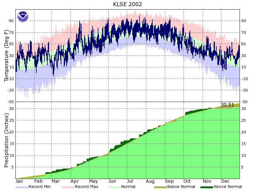
| January | 35.8 | 19.9 | 27.9 | +12.0 | 0.44 | -0.75 | 6.4 |
| February | 38.7 | 21.3 | 30.0 | +7.4 | 2.20 | +1.21 | 6.2 |
| March | 37.8 | 19.9 | 28.8 | -5.8 | 1.52 | -0.48 | 8.5 |
| April | 57.0 | 38.0 | 47.5 | -0.9 | 4.28 | +0.90 | 10.8 |
| May | 68.2 | 44.5 | 56.4 | -4.2 | 1.31 | -2.07 | 0.0 |
| June | 80.7 | 61.4 | 71.0 | +1.4 | 6.39 | +2.39 | ... |
| July | 86.9 | 66.5 | 76.7 | +2.7 | 3.75 | -0.50 | ... |
| August | 81.1 | 60.6 | 70.9 | -0.7 | 2.70 | -1.58 | ... |
| September | 76.3 | 54.7 | 65.5 | +2.8 | 3.68 | +0.28 | ... |
| October | 53.0 | 37.5 | 45.3 | -5.3 | 3.33 | +1.17 | 0.8 |
| November | 43.6 | 26.0 | 34.8 | -0.7 | 0.55 | -1.55 | 2.7 |
| December | 35.5 | 19.9 | 27.7 | +5.9 | 0.36 | -0.87 | 1.7 |
| TOTALS: | 57.9 | 39.2 | 48.5 | +1.2 | 30.51 | -1.85 | *** |
Records
Temperature...
Highs:
Lows:
Highest Lows:
Lowest Highs:
Monthly:
Seasonal:
Yearly:
Other:
Precipitation...
One-day pcpn:
One-day snowfall:
Monthly pcpn:
Monthly snowfall:
Seasonal precipitation:
Yearly precipitation:
|
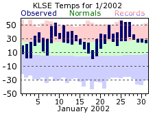
2002 started off very mild, continuing the trend from the last two months of 2001. The first few days of January were around the seasonable normals, but then shot quickly upward, averaging well above normal through the end of the month. Several daily high temperature records were set, with the month rounding out as the 5th warmest January on record. There wasn’t a lot of snowfall this past January either, which is usually the snowiest month of the winter season. The bulk of the snow that fell came on the last day of the month, continuing into the start of February.
|
 |
| For February, it was another winter month that had temperatures more fitting for early spring. More precipitation fell this month, ending a string of 4 consecutive months with below or near normal precipitation. However, because of the warmth, much of what fell came as rain rather than snow. With the end of February also came the end of the unseasonably mild conditions, leading into a rather cool spring. The winter months (Dec-Jan-Feb) of 2001-02 did finish as the 3rd warmest on record. | 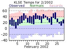 |
|
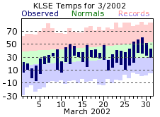
As noted, March saw the start of a downward trend in the temperatures, averaging almost 6 degrees below normal for the month. In fact, March was colder than both February and December, and only a degree warmer than January. Another interesting tidbit related to the temperature is that is took until March 3rd for mercuries to dip below zero degrees. This is the latest on record for this to happen. Looking back on the entire winter, La Crosse had only 2 days with temperatures dropping below zero (one day did fall to zero, but not below), which tied the record for least amount of below zero days in a winter season (the El Nino year of 1997-98 also only had 2 below zero days). For precipitation, March was about a half inch below normal, but close to normal for snowfall. Over half of the monthly total fell on the second. Also, as it usually does when winter starts to give way to spring, the winds began to increase, with the area experiencing many more windy days. The most blustery day was on the 9th, where the average wind speed for the day was 22 mph with a gust up to 45.
|
 |
|
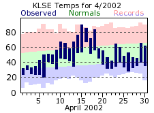
April was probably the most “confused” of the months in 2002, not sure what season it should emulate or transition to. The month started out cold, with 4 inches of snow falling on the first two days. By the middle of the month, temperatures had climbed well above normal, reaching a June-like 90 degrees on the 15th. Just a mere week later though, 4.5 inches of snow fell across the La Crosse area, which tied March 2nd as the snowiest day of last winter. The snow wasn’t done either, with an additional 2 plus inches falling on the 27th. In both cases, high temperatures for the day, along with a relatively warm ground, melted the snow quickly. In the end, April ended up being the snowiest month of the past winter, 9 inches above its normal amount. It was also the 4th snowiest April on record.
|
 |
|
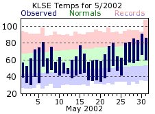
Snow wasn’t a concern for May, with nary a trace for La Crosse. That could almost be said for precipitation in general, as less than 1 ½ inches fell for the entire month. This was over 2 inches below normal. It was also rather cool, waiting until the last week of the month to warm into a semblance of summer. The last of the traditional spring months had its share of windy days, with the strongest on the 9th, averaging over 20 mph for the day with gusts up to 48.
|
 |
|
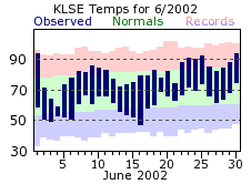
After a 94 degree start to June, rain and clouds dropped temperatures back to those cool reading of May. The cold stint would be brief though, with highs climbing back into the 80s and 90s for most the remainder of the month. Rain was the main story for June, with nearly 2 ½ inches more water than usual. The wettest stretch was that period at the start of the month, with almost 3 inches falling from the 2nd through 4th.
|
 |
|
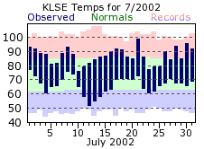
July stayed warm, with 11 days of 90 degree or better temperatures. The warmest day of the year was recorded this month, just missing the century mark with a 99 degree day on the 21st. July was drier compared to June, but only ½ inch below its normal. There was a stretch of 12 days during mid month with only 0.05 inches of rain fell. Otherwise, the rainfall was distributed relatively evenly.
|
 |
|
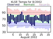
August was the coolest of the summer months, and only had one day where it climbed to 90 degrees of greater. It was also rather dry, with a deficit of over 1 ½ inches compared to its normal. The bulk of the monthly total also came on 2 days, with 56% of August’s rain falling on the 3rd and 21st. In addition, there were a couple dry streaks of note. There was a week stretch near the start of the month with only a trace of rainfall, while the last 8 days did not record even a drop in La Crosse. Overall, the traditional summer (Jun-Jul-Aug) months were fairly normal as a whole for precipitation, while a bit warmer than usual.
|
 |
|
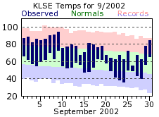
A rather warm start to September led to the month being above normal for temperatures. High temperatures spiked into the 90s by the second week, but then fell more in step with the seasonable normals for the rest of the month. Precipitation for this month was also close to the normals, although the last half of the month finished on a wet note. Measurable rain fell on 11 out of the last 13 days of September.
|
 |
|
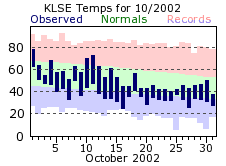
October gave the distinct feel that the calender skipped straight to November, as temperatures averaged over 5 degrees below normal. The first freezing day of the new winter season occurred this month, on the 15th, which is actually later than it historically is. However, mercuries reached 32 degrees or colder 8 times, and high temperatures were steady in the 40s for the last half of the month. For precipitation, the first trace of snowfall came on the 16th, while the first measurable snow of the winter season fell on the 24th. The bulk of the wetting for October came in the first few days of the month though, with over 60 percent of the monthly total falling on the 2nd through 4th.
|
 |
|
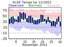
November was rather typical for temperatures, with the average for the month coming in right around its normal. There were more freezing days than usual though, with low temperatures at or below 32 degrees on 27 of the 30 days. It was rather dry by November standards, over 1 ½ inches below normal, and measurable precipitation only fell on 5 days.
|
 |
|
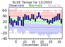
December started off rather chilly, with low temperatures falling into the single digits on 6 of the first 9 days. After that, however, the mild conditions that have become the norm for recent Decembers returned, with temperatures averaging above normal for the rest of the month. December continued November’s dry trend, recording measurable precipitation on only 4 days. Snowfall also suffered as a result, with less than 2 inches for the month, and a Christmas day without snow. The last “non‑white” Christmas previous to this one was in 1997.
|
 |
 |
| Highest temperature for 2002 | 99 on July 21st |
| Lowest temperature for 2002 | -6 on March 4th |
| Highest one-day precipitation | 1.36 inches on June 3rd |
| Highest one-day snowfall | 4.5 inches on March 2nd and April 21st |
| Number of days with highs at or above 90 degrees | 22 |
| Number of days with highs at or below 32 degrees | 47 |
| Number of days with zero or below temperatures | 3 |
| Peak wind gust | 51 mph from the west on July 30th |
| Number of days with measurable precipitation | 125 |
| Percentage of days with measurable precipitation | 34% |
| Number of days with above normal temperatures | 193 |
| Percentage of days with above normal temperatures | 53% |

