Overview
|
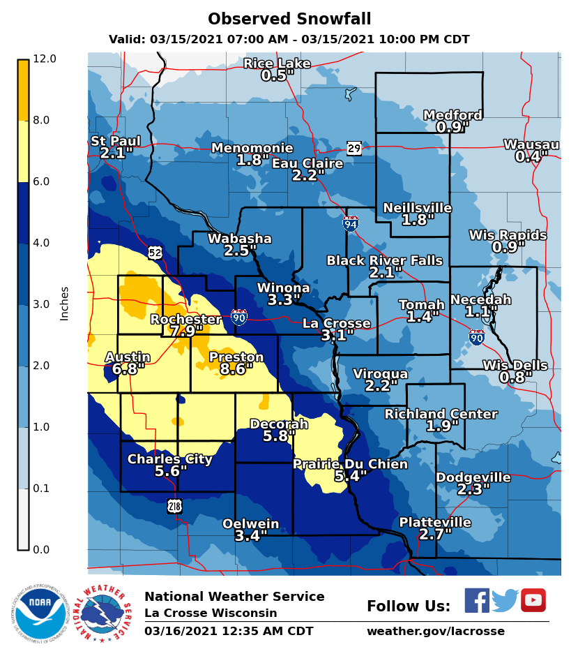
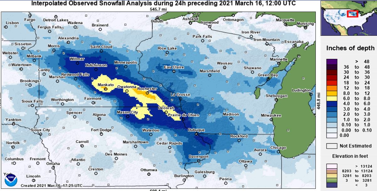
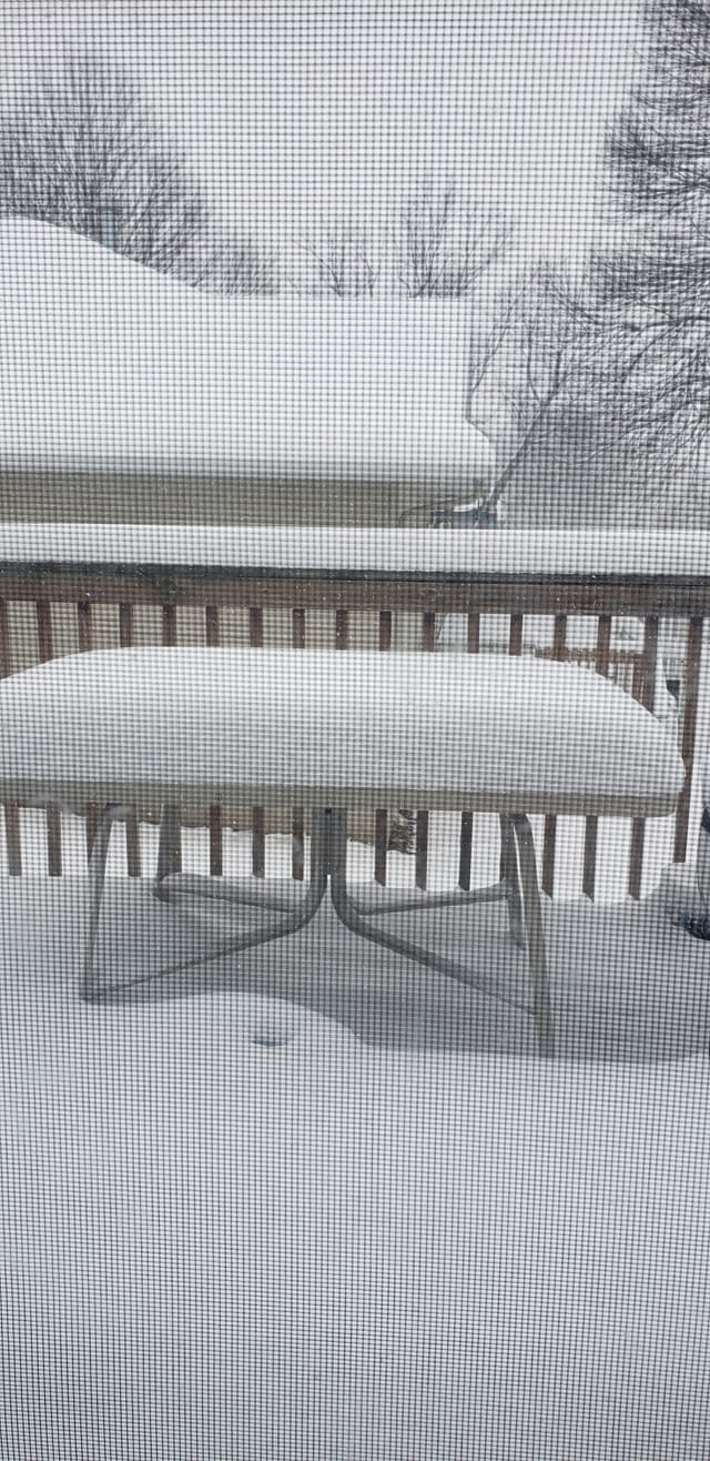
A late season winter storm brought sleet and heavy snow to parts of the Upper Mississippi River Valley Monday, March 15th 2021. The sleet and snow moved in from the southwest early that morning, gradually spreading across the area through the day. Early on the snow had to contend with dry air across Wisconsin which delayed the onset east of the river. It transitioned over to all snow as well. The storm system was also in a weakening trend as it was exiting. As the snow band lifted northeast, patchy freezing drizzle developed behind it, but accumulations were fairly light and minor. The bulk of the snow fell west of the Mississippi river, with an enhanced northwest-southeast running band resulting in 6 to 10 inches across parts of southeast Minnesota and northeast Iowa. There were some gusty winds, but the heavy nature of the snow limited blowing and drifting. Rochester, MN recorded 7.9 inches of snow, breaking the previous daily record of 2.1 inches from 1998.
|
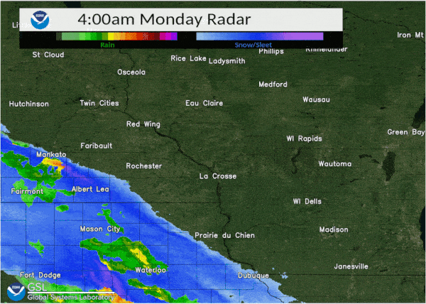 Hourly radar for Monday, March 15, 2021 |
Snow
...SNOWFALL REPORTS...

Location                     Amount    Time/Date       Lat/Lon

...IOWA...

...Allamakee County...
Monona 9.8 N                 6.5 in    0700 AM 03/16   43.19N/91.35W
Postville 5.5 NE             6.2 in    0700 AM 03/16   43.14N/91.49W
Harpers Ferry 6.4 SSW        5.9 in    0700 AM 03/16   43.11N/91.20W

...Chickasaw County...
New Hampton 0.4 SW           4.0 in    0700 AM 03/16   43.06N/92.32W

...Clayton County...
Elkader 6.8 WSW              6.0 in    0600 AM 03/16   42.81N/91.52W
Elkader 6SSW                 5.2 in    0700 AM 03/16   42.78N/91.45W
1 NNW Guttenberg             5.0 in    0401 PM 03/15   42.80N/91.11W
Guttenberg Dam 10            4.0 in    0600 AM 03/16   42.79N/91.10W

...Fayette County...
3 NNW Fayette                4.5 in    0605 AM 03/16   42.88N/91.83W
Fayette                      3.0 in    0700 AM 03/16   42.88N/91.83W

...Floyd County...
Charles City                 8.0 in    0700 AM 03/16   43.06N/92.67W
Marble Rock                  5.0 in    1151 AM 03/15   42.96N/92.87W
Nashua 2SW                   4.5 in    0700 AM 03/16   42.94N/92.57W

...Mitchell County...
Carpenter                    7.5 in    0530 PM 03/15   43.41N/93.02W
St Ansgar                    7.6 in    0630 AM 03/16   43.38N/92.92W
Osage                        5.0 in    0700 AM 03/16   43.28N/92.81W

...Winneshiek County...
8 ENE Decorah                6.7 in    0830 AM 03/16   43.34N/91.64W
Decorah 4.9SE                6.5 in    0700 AM 03/16   43.26N/91.70W
7 ENE Decorah                5.0 in    0830 AM 03/16   43.34N/91.64W
Calmar                       4.2 in    0204 PM 03/15   43.19N/91.86W

...MINNESOTA...

...Dodge County...
1 ENE Kasson                 8.5 in    0611 PM 03/15   44.04N/92.74W

...Fillmore County...
Wykoff 3.1 NW                8.3 in    0700 AM 03/16   43.74N/92.31W
Mabel                        6.6 in    0600 AM 03/16   43.52N/91.76W
Harmony                      6.3 in    0153 PM 03/15   43.55N/92.01W
Chatfield                    5.5 in    0153 PM 03/15   43.84N/92.19W
Preston                      5.0 in    0800 AM 03/16   43.67N/92.07W
Peterson 1S                  4.5 in    0615 PM 03/15   43.77N/91.83W

...Houston County...
La Crescent 1.0 WSW          4.3 in    0700 AM 03/16   43.83N/91.32W
Eitzen                       4.0 in    0841 PM 03/15   43.51N/91.46W
Hokah 4 NW                   3.7 in    0700 AM 03/16   43.80N/91.43W
La Crescent 5.4 SW           2.7 in    0700 AM 03/16   43.78N/91.39W
Caledonia                    2.6 in    0700 AM 03/16   43.63N/91.50W

...Mower County...
Lyle                         8.0 in    0249 PM 03/15   43.53N/92.92W
Austin 2SW                   7.0 in    0627 PM 03/15   43.65N/92.99W
Lansing 2NE                  7.0 in    0649 PM 03/15   43.76N/92.95N
Austin 1WSW                  6.8 in    0302 PM 03/15   43.67N/92.98N
Austin 2.4 W                 6.2 in    0700 AM 03/16   43.67N/93.02W

...Olmsted County...
Rochester 4.2 N             10.0 in    0600 AM 03/16   44.08N/92.49W
Byron                        9.3 in    0854 PM 03/15   44.03N/92.65W
3 SW Cummingsville           9.0 in    0722 AM 03/16   43.85N/92.30W
2 NE Rochester               9.0 in    0600 AM 03/16   44.04N/92.44W
Rochester Intl Airport       7.9 in    0700 PM 03/15   43.90N/92.49W
Stewartville 4.3 E           7.5 in    0400 AM 03/16   43.86N/92.40W
Rochester 4.7 N              6.8 in    0700 AM 03/16   44.08N/92.48W
Elgin 2SSW                   4.2 in    0700 AM 03/16   44.10N/92.27W

...Wabasha County...
Theilman 1 SSW               4.0 in    0730 AM 03/16   44.28N/92.19W
Zumbro Falls 3.5 SSW         3.3 in    0708 AM 03/16   44.24N/92.46W
0.9 N Wabasha                2.5 in    0700 AM 03/16   44.38N/92.05W
Lake City                    2.0 in    0817 AM 03/16   44.45N/92.27W

...Winona County...
Winona 1.3 SSW               3.7 in    0730 AM 03/16   44.03N/91.68W
4.2 N Rollingstone           3.0 in    0800 AM 03/16   44.16N/91.81W
Winona                       3.0 in    0855 PM 03/15   44.05N/91.66W

...WISCONSIN...

...Adams County...
Nekoosa 8.0 SSE              2.0 in    0700 AM 03/16   44.21N/89.85W
0.6 W Friendship             1.0 in    0700 AM 03/16   43.98N/89.83W
Oxford 4.0 W                 1.0 in    0700 AM 03/16   43.79N/89.64W
Friendship 6.4 N              T in     0700 AM 03/16   44.06N/89.80W

...Buffalo County...
Cochrane                     3.5 in    0800 PM 03/15   44.22N/91.84W
Mondovi 12.1 SSE             3.3 in    0630 AM 03/16   44.40N/91.60W

...Clark County...
Owen 1E                      1.0 in    0700 AM 03/16   44.95N/90.55W

...Crawford County...
Prairie Du Chien             5.3 in    0700 AM 03/16   43.05N/91.13W
DeSoto 1S                    4.5 in    0841 PM 03/15   43.41N/91.19W
Eastman                      4.2 in    0726 AM 03/16   43.17N/91.02W
2.8 E Harpers Ferry          4.0 in    0800 AM 03/16   43.21N/91.10W
Steuben 4SE                  3.5 in    0745 AM 03/16   43.13N/90.84W

...Grant County...
Cassville 7.8 ENE            4.4 in    0700 AM 03/16   42.75N/90.84W
4.3 W Lancaster              3.0 in    0800 AM 03/16   42.83N/90.79W
Blue River                   2.0 in    0332 PM 03/15   43.19N/90.57W

...Jackson County...
1 W Melrose                  2.0 in    0530 PM 03/15   44.13N/91.01W
Black River Falls 1.7 NNE    1.7 in    0700 AM 03/16   44.32N/90.83W

...Juneau County...
1.0 E Mauston                2.0 in    0800 AM 03/16   43.79N/90.06W

...La Crosse County...
La Crosse 4NNW               4.0 in    0730 AM 03/16   43.87N/91.27W
La Crosse Airport            3.9 in    0730 AM 03/16   43.86N/91.27W
Holmen 2SSE                  3.2 in    0700 AM 03/16
Coon Valley 4.5 NNW          3.0 in    0700 AM 03/16   43.76N/91.06W
West Salem                   1.9 in    0700 AM 03/16   43.90N/91.09W

...Monroe County...
Cashton 3 NNW                2.3 in    0721 AM 03/16   43.79N/90.80W
Tomah                        1.8 in    0930 PM 03/15   43.99N/90.50W
0.5 SW Sparta                1.0 in    0800 AM 03/16   43.94N/90.82W
3 NNE Tunnel City            1.0 in    0819 AM 03/16   44.04N/90.55W

...Taylor County...
Medford 0.8 ENE              0.8 in    0700 AM 03/16   45.14N/90.33W

...Trempealeau County...
Ettrick 4.0 WNW              3.1 in    0711 AM 03/16   44.19N/91.34W
2 NE Independence            3.0 in    0700 AM 03/16   44.39N/91.39W
Trempealeau Dam 6            3.0 in    0800 AM 03/16   44.00N/91.44W
Galesville 4.7 E             2.2 in    0751 AM 03/16   44.08N/91.26W

...Vernon County...
0.5 E Viroqua                3.4 in    0700 AM 03/16   43.56N/90.88W
Stoddard 4.7 NNE             3.3 in    0700 AM 03/16   43.72N/91.17W
Genoa Dam 8                  3.0 in    0700 AM 03/16   43.57N/91.23W
Hillsboro 2 SW               2.5 in    0700 AM 03/16   43.63N/90.38W
Hillsboro 0.5 WSW            2.3 in    0700 AM 03/16   43.65N/90.35W
Viroqua 0.8 ESE              2.0 in    0700 AM 03/16   43.55N/90.87W
Readstown                    1.5 in    0518 PM 03/15   43.44N/90.75W

Observations are collected from a variety of sources with varying
equipment and exposures. We thank all volunteer weather observers
for their dedication. Not all data listed are considered official.
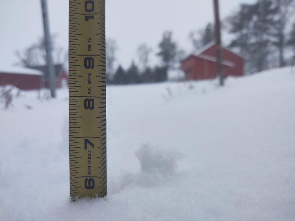
Photos:
 |
 |
||
| East of Rockford, IA (Photo by Brad Gorman) |
Spring Valley, MN (Photo by Randee Wesely) |
Caption (source) |
Caption (source) |
 |
Media use of NWS Web News Stories is encouraged! Please acknowledge the NWS as the source of any news information accessed from this site. |
|


 Weather Story
 Weather Map
 Local Radar