Upper Mississippi River Valley March 2022 Climate Summary
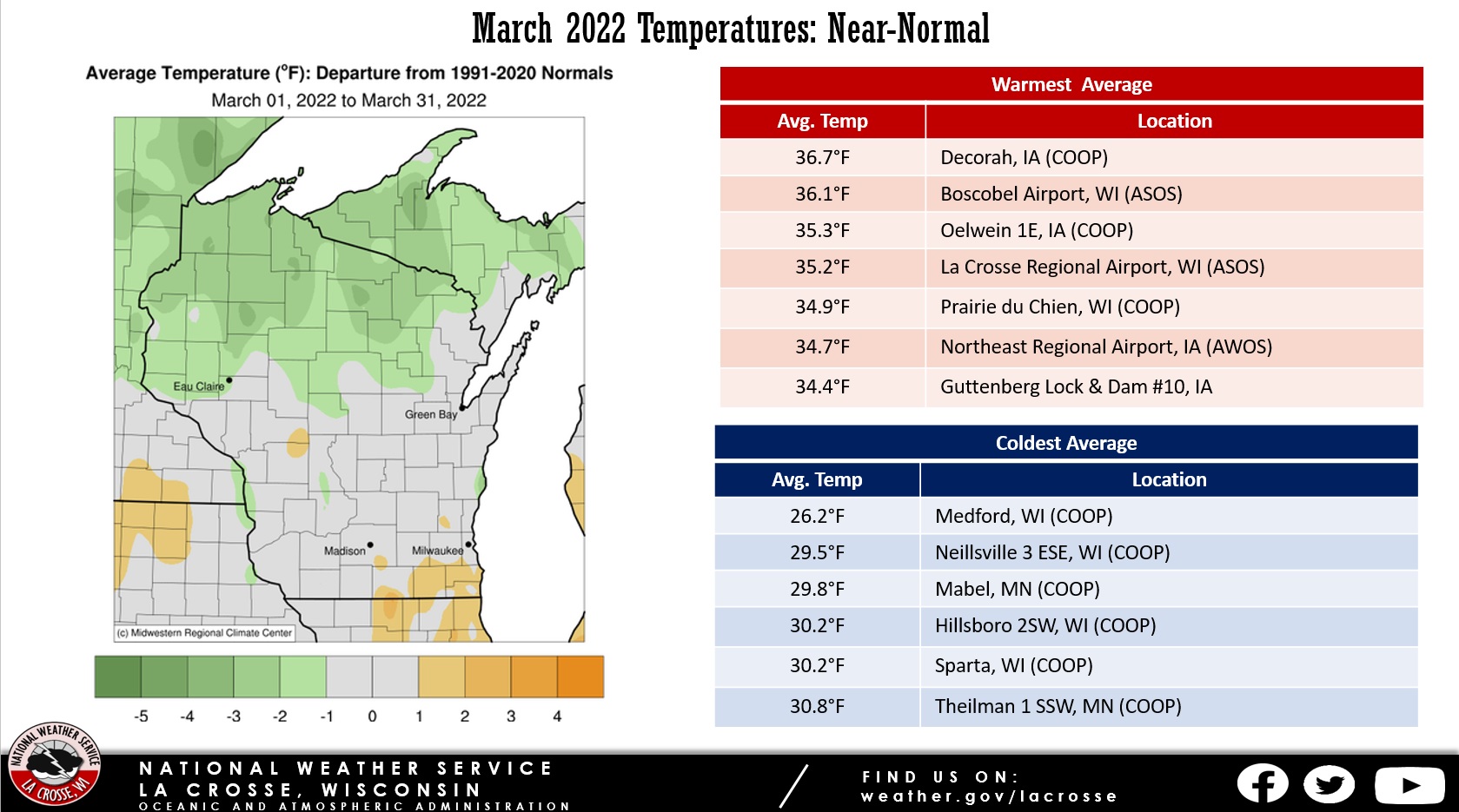
Temperatures - Near-Normal
| During March 2022, average temperatures ranged from 26.2°F at Medford, WI (COOP observer) to 36.7°F in Decorah, IA (COOP observer) in the Upper Mississippi River Valley. These temperatures were near normal ranging from 2°F below to 2°F above normal. The warmest temperature was 77°F at the Boscobel Airport on March 21. Meanwhile, the coldest temperature was -8°F at the Medford, WI COOP on March 12. This was an 85°F difference. |
 |
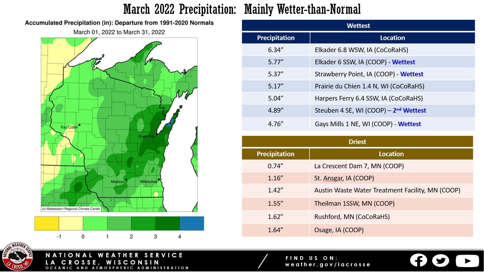
Precipitation - Mainly Wetter than Normal
| Precipitation ranged from 0.74" at La Crescent Dam 7, MN (COOP observer) to 6.34" near Elkader, IA (CoCoRaHS observer). This precipitation ranged from near normal to 4" wetter than normal. March precipitation records were set at the following cooperative observing sites: Elkader, IA (5.77" - previous record 5.71" in 1951 - records date back to 1893); Gays Mills, WI (4.76" - the previous record was 4.07" in 2004 - records date back to 1956); and Strawberry Point, IA (5.37" - the previous record was 5.28" in 1951 - records date back to 1949). The highest one-day precipitation was 1.92" near Elkader, IA (COOP observer) from March 5-6. |
 |
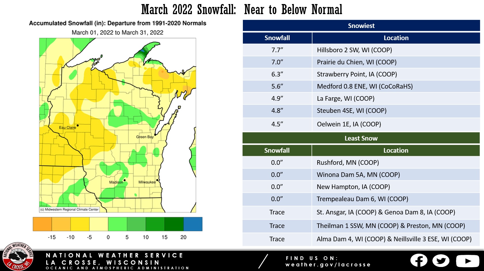
Snowfall - Near to Below Normal
| March snowfall ranged from no snow to 7.7" near Hillsboro, WI (COOP observer). This snowfall ranged from 10" below normal to 5" above normal. The highest one-day snowfall was 6.6" near Prairie du Chien, WI (CoCoRaHS observer) from March 6-7. |
 |
Below are the March 2022 climate summaries for La Crosse, WI, and Rochester, MN.
La Crosse, WI
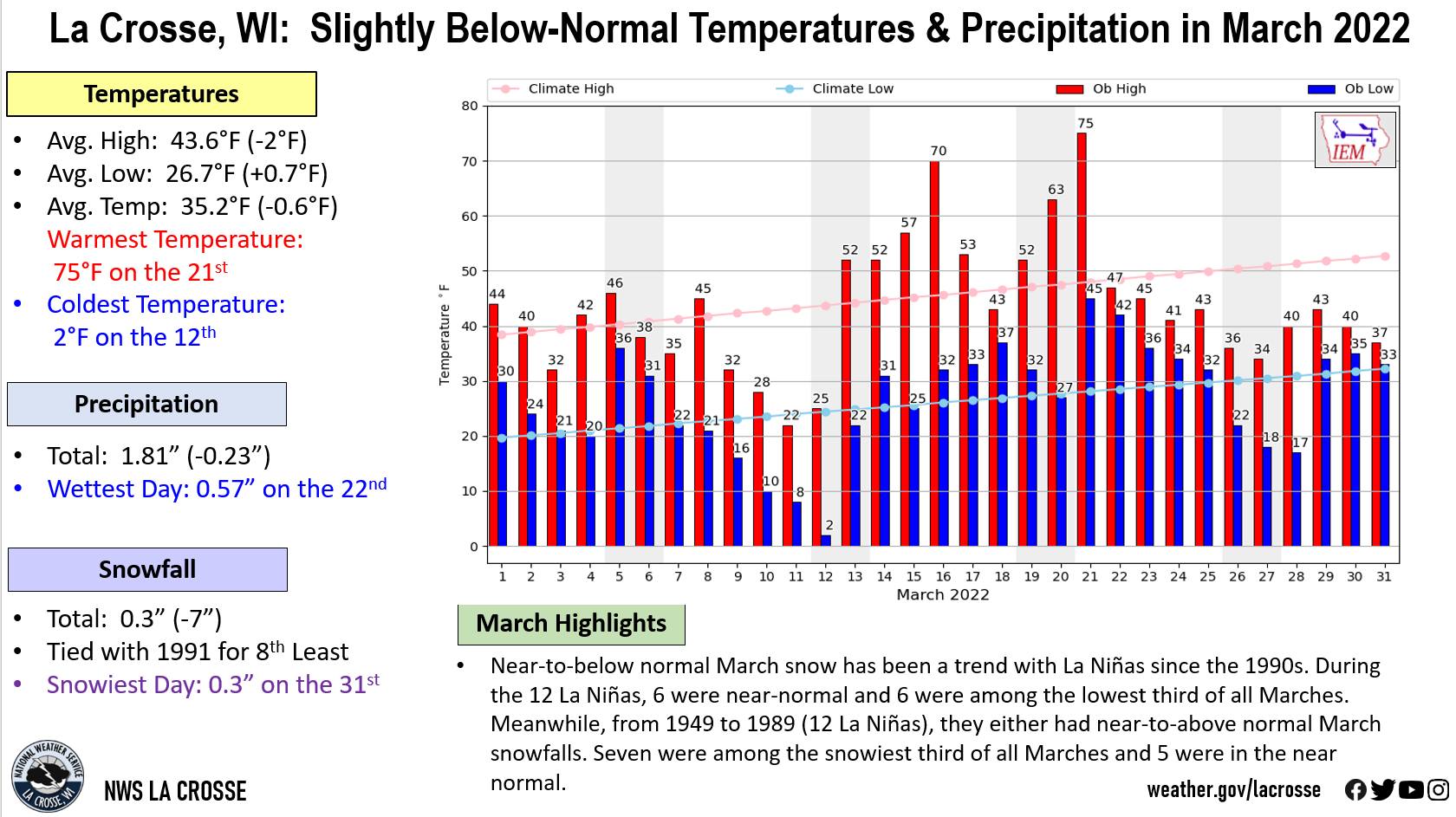
Slightly Cooler and Drier than Normal at La Crosse, WI
...March 2022 Highlights...
Temperatures...Slightly Cooler than Normal
- The average temperature at La Crosse Regional Airport was 35.2°F. This was 0.6°F cooler than the 1991-2020 normal of 35.8°F. This was the coolest March since 2019 (30.2°F).
- The average high temperature was 43.6°F. This was 2°F colder than 1991-2020 normal of 45.6°F. This was the coolest March since 2019 (40.4°F).
- The average low temperature was 26.7°F. This was 0.7°F warmer than 1991-2020 normal of 26°F. This was the coolest March since 2019 (20.1°F).
- The warmest temperature was 75°F on March 21.
- The coldest temperature was 2°F on March 12.
|
 |
Precipitation...Slightly Below Normal
- A total of 1.81" of precipitation fell. This was 0.23" drier than 1991-2020 normal of 2.04 inches.
- The wettest day was 0.57" on March 22.
Snowfall...Tied with 1991 for the 8th Least
- A total of 0.3" of snow fell. Which was 7" below the 1991-2020 normal of 7.3". This was tied with 1991 for the 8th least in March. This was the least snow in March since 2010 (no snow - least ever in March). Below are the ten Marches with the least amount of snow.
Least Amount of Snow
in March for La Crosse WI
1897-2022
Rank Snowfall Year
---- -------- ----
1 0.0 inches 2010
2 Trace 1990
Trace 1986
Trace 1973
Trace 1919
6 0.1 inches 1968
7 0.2 inches 1910
8 0.3 inches 2022
0.3 inches 1991
10 0.5 inches 2012
0.5 inches 1949
- The near-to-below normal March snow has been a trend in La Niñas since the 1990s. During the 12 La Niñas, 6 were in the near-normal tercile and 6 were among the lowest third of all Marches. From 1949 to 1989 (12 La Niñas), they either had near-to-above normal March snowfalls. Seven were among the snowiest third of all Marches and 5 were in the near-normal tercile.
- The snowiest day was 0.3" on March 31.
Snow Depth...Below Normal
- The average snow depth was 0.4". This was 1.6" below the long-term average (1893-2022) of 2".
- The greatest snow depth was 3" from March 1 through March 3.
...Records...
- Daily...
- Tied Record High - March 21 - 75°F - Last set back in 1911
...Looking ahead to April...
- The normal high temperature in La Crosse starts off at 53°F on April 1st and warms to 66°F by the end of the month. The normal low temperature starts off at 33°F on the 1st and warms to 44°F by the end of the month. The warmest April temperature on record is 93°F on April 29, 1910, and April 22, 1980; and the coldest is -7°F on April 1, 1924, and April 6, 1982.
- The normal mean temperature for April is 49°F. La Crosse’s warmest April occurred in 1915 with an average temperature of 56.9°F, and their coldest April occurred in 1874 and 2018 with an average temperature of 39.3°F.
- The normal April precipitation is 3.75". The wettest April occurred in 1973 with 7.31" of precipitation and the driest occurred in 1879 with 0.42". The wettest April day occurred on April 27, 1975, when 3.91" of precipitation fell. Normally, there are 3 days with thunderstorms.
- The normal April snowfall is 2.9". The snowiest April occurred in 2018 with 19" of snow. The snowiest April day occurred on April 9, 1973, when 10.3" of snow fell.
Rochester, MN
Slightly Warmer and Wetter than Normal at Rochester MN
...March 2022 Highlights...
Temperatures...Slightly Warmer than Normal
- The average temperature at Rochester International Airport was 32.3°F. This was 0.6°F warmer than 1991-2020 normal of 31.7°F. This was the coolest March since 2019 (25.9°F).
- The average high temperature was 39.9°F. This was normal. This was the coolest March since 2019 (33.9°F).
- The average low temperature was 24.7°F. This was 1.3°F warmer than the 1991-2020 normal of 23.4°F. This was the coolest March since 2019 (17.9°F).
- The warmest temperature was 69°F on March 21.
- The coldest temperature was 0°F on March 12.
|
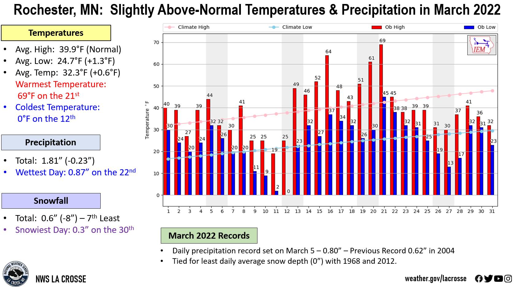 |
Precipitation...Slightly Wetter than Normal
- A total of 2.29" of precipitation fell. This was 0.27" wetter than the 1991-2020 normal of 2.02 inches.
- The wettest day was 0.87" on March 22.
Snowfall...7th Least
- A total of 0.6" of snow fell. Which was 8" inches below 1991-2020 normal of 8.3 inches. This was the 7th least in March. This was the least snow in March since 2012 (trace of snow - tied for 2nd least in March with 1910 and 1981). Below are the ten Marches with the least amount of snow.
Least Amount of Snow
in March for Rochester MN
1893-2022
Rank Snowfall Year
---- -------- ----
1 0.0 inches 2010
2 Trace 2012
Trace 1981
Trace 1910
5 0.4 inches 1968
6 0.5 inches 1990
7 0.6 inches 2022
8 1.2 inches 2009
1.2 inches 1986
10 1.3 inches 1946
- The snowiest day was 0.3" on March 30.
Snow Depth...Tied with 1968 and 2012 for the Least
- The average snow depth was 0.0". This was 3.3" below the long-term average (1940-2022) of 3.3". This was tied with 1968 and 2012 for the least.
- The greatest snow depth was 1" on March 1.
...Records...
- Daily...
- Precipitation Record - March 5 - 0.80" - Previous Record 0.62" in 2004
...Looking ahead to April...
- The normal high temperature in Rochester starts off at 48°F on April 1st and warms to 62°F by the end of the month. The normal low temperature starts off at 30°F on the 1st and warms to 41°F by the end of the month. The warmest April temperature on record is 92°F on April 24, 2009, and the coldest is 5°F on April 6, 1982.
- The normal mean temperature for April is 45.2°F. Rochester’s warmest April occurred in 1915 with an average temperature of 54.5°F, and its coldest April occurred in 2018 with an average temperature of 34.5°F.
- The normal April precipitation is 3.52". The wettest April occurred in 2001 with 7.30" of precipitation and the driest occurred in 1946 with 0.46". The wettest April day occurred on April 23, 1990, when 3.81" of precipitation fell. Normally, there are 3 days with thunderstorms.
- The normal April snowfall is 3.3". The snowiest April occurred in 2018 with 17" of snow. The snowiest April day occurred on April 20, 1893, when 14" of snow fell.


 Weather Story
 Weather Map
 Local Radar