Overview
Thunderstorms developed in the early afternoon of Friday, May 25th near and north of Interstate 90 in southeast Minnesota. The storms slowly moved east through the afternoon and produced pockets of quarter-sized hail and wind damage. The largest report of hail we received was to the size of golf balls in the town of Eleva, WI in northern Trempealeau County.
Radar:
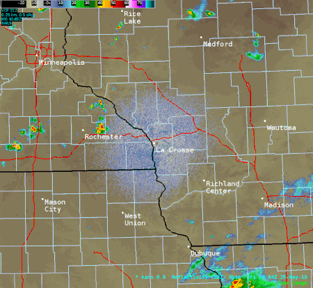 |
|||
| Radar loop from about 2 to 10 pm May 25 2018. |
Storm Reports
A look at storm reports received by our office is below. A graphical version is also available.

PRELIMINARY LOCAL STORM REPORT...SUMMARY
NATIONAL WEATHER SERVICE LA CROSSE WI
211 PM CDT SAT MAY 26 2018

..TIME...   ...EVENT...      ...CITY LOCATION...     ...LAT.LON...
..DATE...   ....MAG....      ..COUNTY LOCATION..ST.. ...SOURCE....
            ..REMARKS..

0247 PM     HAIL             WHITEWATER STATE PARK   44.06N 92.04W
05/25/2018  E1.00 INCH       WINONA             MN   PARK/FOREST SRVC

            WHITEWATER STATE PARK EMPLOYEE SAID A FEW
            HAILSTONES COULD HAVE BEEN A LITTLE BIGGER.

0254 PM     HAIL             SAINT CHARLES           43.97N 92.06W
05/25/2018  E0.75 INCH       WINONA             MN   LAW ENFORCEMENT


0331 PM     HAIL             ELEVA                   44.58N 91.47W
05/25/2018  E1.75 INCH       TREMPEALEAU        WI   LAW ENFORCEMENT


0336 PM     HAIL             LEWISTON                43.98N 91.87W
05/25/2018  E1.00 INCH       WINONA             MN   LAW ENFORCEMENT


0339 PM     HAIL             LEWISTON                43.98N 91.87W
05/25/2018  E0.75 INCH       WINONA             MN   PUBLIC


0425 PM     HAIL             AUSTIN                  43.67N 92.97W
05/25/2018  E0.88 INCH       MOWER              MN   BROADCAST MEDIA


0430 PM     HAIL             OSAGE                   43.28N 92.81W
05/25/2018  E0.50 INCH       MITCHELL           IA   EMERGENCY MNGR

            HALF INCH HAIL FOR APPROXIMATELY 15 MINUTES.

0432 PM     HAIL             2 SW AUSTIN             43.65N 92.99W
05/25/2018  E0.50 INCH       MOWER              MN   PUBLIC


0500 PM     HAIL             RUSHFORD                43.81N 91.75W
05/25/2018  E0.88 INCH       FILLMORE           MN   PUBLIC

            TIME ESTIMATED FROM RADAR.

0510 PM     HAIL             3 N THORP               45.00N 90.80W
05/25/2018  E1.00 INCH       CLARK              WI   PUBLIC


0520 PM     TSTM WND GST     1 NNE FRENCH ISLAND     43.87N 91.25W
05/25/2018  M47 MPH          LA CROSSE          WI   ASOS


0520 PM     TSTM WND GST     3 ENE MOUND PRAIRIE     43.80N 91.40W
05/25/2018  M56 MPH          HOUSTON            MN   TRAINED SPOTTER


0540 PM     TSTM WND DMG     CALEDONIA               43.64N 91.50W
05/25/2018                   HOUSTON            MN   LAW ENFORCEMENT

            NUMEROUS TREES DOWN AND SOME POWER LINES
            DOWN BETWEEN HOUSTON AND BROWNSVILLE.

0540 PM     HAIL             OSAGE                   43.28N 92.81W
05/25/2018  E0.50 INCH       MITCHELL           IA   TRAINED SPOTTER


0543 PM     HAIL             5 WSW MEDFORD           45.11N 90.44W
05/25/2018  E1.00 INCH       TAYLOR             WI   PUBLIC

            ESTIMATION OF QUARTER SIZED HAIL FROM
            FACEBOOK VIDEO. TIME ESTIMATED FROM RADAR.

0545 PM     TSTM WND GST     5 NE STODDARD           43.72N 91.17W
05/25/2018  E35 MPH          VERNON             WI   PUBLIC


0601 PM     HAIL             4 E SPRING GROVE        43.54N 91.56W
05/25/2018  E0.88 INCH       HOUSTON            MN   PUBLIC

            HEAVY RAIN AND WIND GUSTS ESTIMATED AT 50-55
            MPH.

0644 PM     TSTM WND DMG     LANSING                 43.36N 91.22W
05/25/2018                   ALLAMAKEE          IA   LAW ENFORCEMENT

            NUMEROUS REPORTS OF TREES DOWN ACROSS
            NORTHERN ALLAMAKEE COUNTY THE PAST 10-15
            MINUTES.

0700 PM     HAIL             WEST UNION              42.96N 91.81W
05/25/2018  E0.25 INCH       FAYETTE            IA   LAW ENFORCEMENT


0704 PM     TSTM WND DMG     WAUKON                  43.27N 91.48W
05/25/2018                   ALLAMAKEE          IA   LAW ENFORCEMENT

            NUMEROUS REPORTS OF ADDITIONAL TREES DOWN
            ACROSS CENTRAL AND SOUTHERN ALLAMAKEE
            COUNTY.

0705 PM     TSTM WND DMG     FERRYVILLE              43.34N 91.08W
05/25/2018                   CRAWFORD           WI   911 CALL CENTER

            SEVERAL REPORTS OF TREES AND POWER LINES
            DOWN BETWEEN FERRYVILLE AND LYNXVILLE. TIME
            ESTIMATED FROM RADAR, BUT DAMAGE LIKELY
            OCCURRED BETWEEN 6:55 PM AND 7:15 PM.

0724 PM     TSTM WND DMG     4 N PRAIRIE DU CHIEN    43.11N 91.14W
05/25/2018                   CRAWFORD           WI   LAW ENFORCEMENT

            TREES DOWN ON POWER LINE NEAR FALLING ROCK
            RD.

0728 PM     TSTM WND DMG     EASTMAN                 43.16N 91.02W
05/25/2018                   CRAWFORD           WI   TRAINED SPOTTER

            TREES REPORTED DOWN NEAR THE VILLAGE OF
            EASTMAN.

0740 PM     TSTM WND GST     GLEN HAVEN              42.83N 91.07W
05/25/2018  E50 MPH          GRANT              WI   PUBLIC


0750 PM     TSTM WND GST     EDGEWOOD                42.65N 91.40W
05/25/2018  M41 MPH          CLAYTON            IA   PUBLIC


0753 PM     TSTM WND GST     WAUZEKA                 43.09N 90.88W
05/25/2018  E60 MPH          CRAWFORD           WI   PUBLIC


0759 PM     TSTM WND GST     4 SW WEST CONCORD       44.12N 92.96W
05/25/2018  M50 MPH          DODGE              MN   TRAINED SPOTTER


0800 PM     TSTM WND DMG     DODGE CENTER            44.03N 92.85W
05/25/2018                   DODGE              MN   LAW ENFORCEMENT

            A FEW REPORTS OF TREES AND POWER LINES DOWN
            ACROSS THE NORTHERN HALF OF THE COUNTY. TIME
            ESTIMATED FROM RADAR.

0804 PM     HAIL             OELWEIN                 42.68N 91.92W
05/25/2018  E1.00 INCH       FAYETTE            IA   TRAINED SPOTTER

            PEA TO QUARTER SIZE HAIL.

0815 PM     TSTM WND GST     2 E KASSON              44.02N 92.71W
05/25/2018  M50 MPH          DODGE              MN   MESONET

            MESONET STATION MN029, 2 E KASSON.

0831 PM     TSTM WND GST     4 N STEWARTVILLE        43.91N 92.50W
05/25/2018  M60 MPH          OLMSTED            MN   ASOS

            ROCHESTER INTERNATIONAL AIRPORT OFFICIAL
            OBSERVATION.

0915 PM     TSTM WND DMG     1 WSW RUSHFORD          43.81N 91.77W
05/25/2018                   FILLMORE           MN   LAW ENFORCEMENT

            SEVERAL REPORTS OF TREES DOWN ACROSS THE
            NORTHEAST CORNER OF FILLMORE COUNTY,
            ESPECIALLY NEAR RUSHFORD. TIME ESTIMATED
            FROM RADAR.
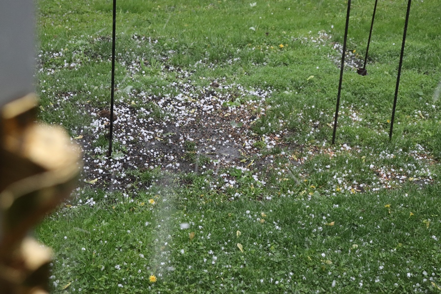
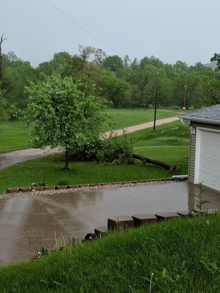
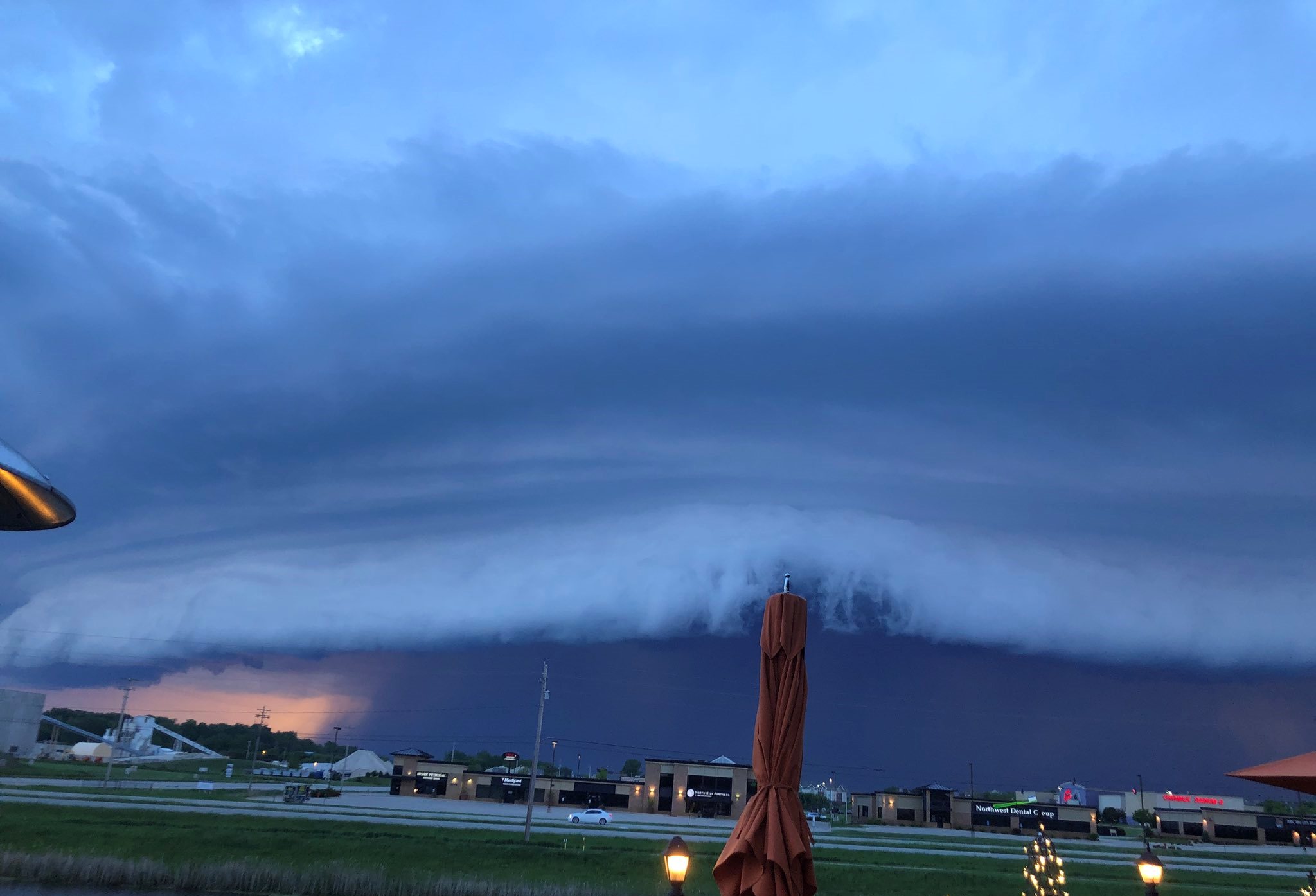
Photos:
Photos received by the National Weather Service. You can always send us photos on Facebook or Twitter.
 |
 |
 |
 |
| Dime-sized hail near Austin, MN (Photo by Rena Langowski) |
Tree blown over near Hokah, MN (Photo by Shawn Jorstad) |
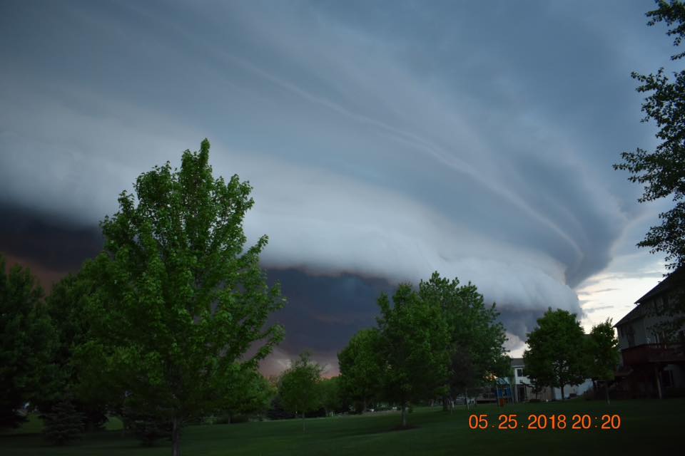
Shelf cloud in Rochester, MN (Photo by James Loghry) |
Another photo of shelf cloud in southwest Rochester, MN (Photo by Sandy Johns) |
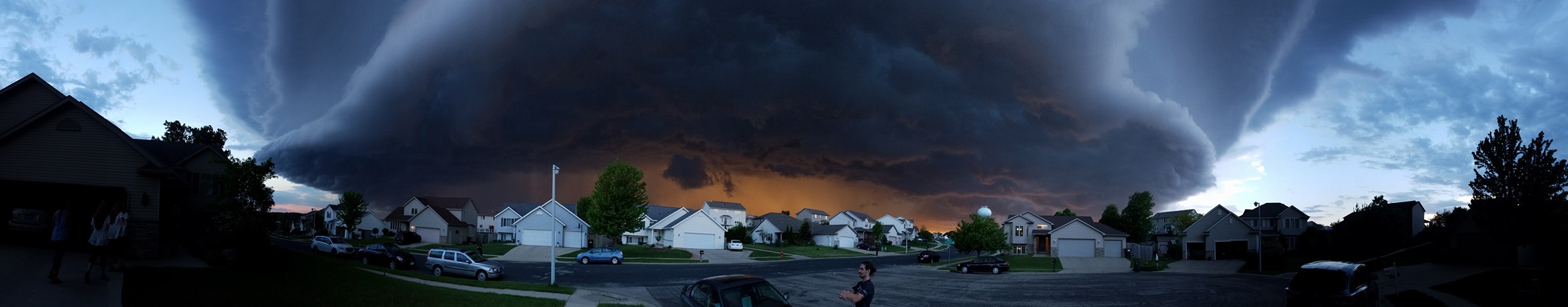 |
| Great panoramic shot of a well-defined shelf cloud entering Rochester, MN (Photo by Adam Logeman) |
Rain Reports
...24 hour Rainfall Reports Ending Saturday Morning...

Location                     Amount    Time/Date       Lat/Lon

...Iowa...

...Allamakee County...
3 SE Waterville              0.90 in   0307 AM 05/26   43.17N/91.24W
3 S Dorchester               0.60 in   0300 AM 05/26   43.42N/91.51W
4 ENE Watson                 0.60 in   0345 AM 05/26   43.11N/91.26W

...Chickasaw County...
Ionia 2W                     0.45 in   0345 AM 05/26   43.03N/92.50W

...Clayton County...
Monona                       1.36 in   0349 AM 05/26   43.04N/91.39W
Elkader 5NW                  0.71 in   0300 AM 05/26   42.91N/91.47W
Littleport                   0.49 in   0345 AM 05/26   42.75N/91.37W
Marquette-Bloody Run Creek   0.23 in   0300 AM 05/26   43.04N/91.21W
Garber                       0.03 in   0315 AM 05/26   42.74N/91.26W

...Fayette County...
Eldorado                     0.64 in   0345 AM 05/26   43.05N/91.81W

...Floyd County...
Charles City-Cedar River     0.30 in   0330 AM 05/26   43.06N/92.67W
Charles City Airport         0.12 in   0655 PM 05/25   43.07N/92.61W
Nashua 2SW                   0.07 in   0300 AM 05/26   42.93N/92.56W

...Howard County...
3 NE Riceville               0.17 in   0354 AM 05/26   43.40N/92.50W

...Winneshiek County...
5 NW Frankville              1.59 in   0340 AM 05/26   43.25N/91.70W
1 ENE Jackson Junction       0.96 in   0350 AM 05/26   43.11N/92.04W
Decorah                      0.36 in   0350 AM 05/26   43.30N/91.79W
Bluffton                     0.28 in   0345 AM 05/26   43.41N/91.90W
Decorah Municipal Airport    0.26 in   0655 PM 05/25   43.28N/91.74W

...Minnesota...

...Dodge County...
Wasioja Alert Gage           0.51 in   0103 AM 05/26   44.07N/92.82W
Mantorville                  0.47 in   1130 PM 05/25   44.07N/92.77W

...Fillmore County...
Pilot Mound-Root River       0.65 in   0400 AM 05/26   43.78N/92.03W
Fillmore                     0.35 in   0330 AM 05/26   43.76N/92.27W
Lanesboro-Root River         0.21 in   0330 AM 05/26   43.72N/91.98W

...Houston County...
Brownsville                  0.48 in   0345 AM 05/26   43.69N/91.27W

...Mower County...
Austin 3S                    0.61 in   0300 AM 05/26   43.64N/92.97W
Austin 3 NW - Turtle Creek   0.42 in   0330 AM 05/26   43.65N/92.98W
Austin 2NE-Dobbins Creek     0.18 in   0330 AM 05/26   43.67N/92.95W
Austin Municipal Airport     0.01 in   0655 PM 05/25   43.66N/92.93W

...Olmsted County...
Elba 4.7 SW                  1.02 in   1030 PM 05/25   44.04N/92.09W
3 N Rochester                0.80 in   0315 AM 05/26   44.06N/92.47W
Elgin 5SE                    0.72 in   0330 AM 05/26   44.01N/92.11W
Eyota 2NE                    0.71 in   0330 AM 05/26   44.01N/92.20W
Oronoco                      0.62 in   0330 AM 05/26   44.16N/92.54W
Oronoco 1W                   0.55 in   0330 AM 05/26   44.17N/92.55W
3 ESE Douglas                0.52 in   0355 AM 05/26   44.09N/92.51W
4 WSW Rochester              0.51 in   0300 AM 05/26   43.98N/92.56W
2 SE Douglas                 0.46 in   0355 AM 05/26   44.08N/92.55W
2 NE Rochester               0.45 in   0353 AM 05/26   44.04N/92.44W
Byron                        0.42 in   0403 AM 05/26   44.03N/92.66W
Rochester-Cascade Creek      0.40 in   0330 AM 05/26   44.03N/92.47W
Rochester-Beltline           0.37 in   0330 AM 05/26   44.01N/92.47W
Pine Island 1S               0.36 in   0300 AM 05/26   44.19N/92.65W
2 ENE Rochester              0.32 in   0330 AM 05/26   44.03N/92.43W
Byron                        0.32 in   0351 AM 05/26   44.04N/92.64W
3 SW Hammond                 0.23 in   0357 AM 05/26   44.18N/92.41W
Oxbow Park Alert Gage        0.08 in   0305 AM 05/26   44.09N/92.64W
Rochester-Beltline Bear Cree 0.02 in   0330 AM 05/26   44.01N/92.45W
2 SE Eyota                   0.01 in   0345 AM 05/26   43.96N/92.21W

...Wabasha County...
Plainview                    1.12 in   0349 AM 05/26   44.17N/92.17W
Kellogg-Zumbro River         0.25 in   0300 AM 05/26   44.32N/92.00W
Plainview                    0.25 in   0357 AM 05/26   44.17N/92.17W
Mazeppa 3ESE                 0.19 in   0330 AM 05/26   44.26N/92.49W
Lake City                    0.03 in   0346 AM 05/26   44.45N/92.27W

...Winona County...
Whitewater State Park        1.17 in   0330 AM 05/26   44.05N/92.05W
Whitewater State Park Group  0.81 in   0330 AM 05/26   44.06N/92.05W
Beaver-White Water River     0.77 in   0345 AM 05/26   44.15N/92.00W
Dakota                       0.74 in   0315 AM 05/26   43.91N/91.36W
Great River Bluffs S.P.      0.60 in   0330 AM 05/26   43.94N/91.41W
Elba                         0.24 in   0345 AM 05/26   44.09N/92.03W
Winona Municipal Airport     0.15 in   0656 PM 05/25   44.08N/91.71W

...Wisconsin...

...Buffalo County...
Cochrane                     1.92 in   0349 AM 05/26   44.22N/91.83W
Mondovi                      1.03 in   0500 PM 05/25   44.56N/91.67W

...Clark County...
Neillsville 1W               0.16 in   0300 AM 05/26   44.56N/90.61W

...Crawford County...
De Soto                      0.43 in   0356 AM 05/26   43.42N/91.19W
Steuben                      0.38 in   0345 AM 05/26   43.18N/90.86W

...Grant County...
Fennimore                    0.56 in   0350 AM 05/26   42.98N/90.66W
1 ENE Boscobel               0.26 in   0303 AM 05/26   43.15N/90.68W

...Juneau County...
Necedah                      0.01 in   0348 AM 05/26   44.03N/90.08W

...La Crosse County...
La Crosse Weather Office     0.36 in   1200 AM 05/26   43.82N/91.19W
La Crosse Regional Airport   0.30 in   0653 PM 05/25   43.88N/91.26W
3 W Saint Joseph             0.02 in   0352 AM 05/26   43.78N/91.10W

...Monroe County...
2 E Cataract                 0.05 in   0358 AM 05/26   44.09N/90.79W
Sparta/Fort McCoy Airport    0.04 in   0655 PM 05/25   43.96N/90.74W

...Taylor County...
Medford Airport              0.15 in   0655 PM 05/25   45.10N/90.30W
3 NE Lublin                  0.13 in   0314 AM 05/26   45.11N/90.69W
Chelsea                      0.04 in   0348 AM 05/26   45.30N/90.30W

...Vernon County...
Readstown                    0.01 in   0300 AM 05/26   43.45N/90.76W

Observations are collected from a variety of sources with varying
equipment and exposures. We thank all volunteer weather observers
for their dedication. Not all data listed are considered official.

$$
 |
Media use of NWS Web News Stories is encouraged! Please acknowledge the NWS as the source of any news information accessed from this site. |
|


 Weather Story
 Weather Map
 Local Radar