On October 20th, low pressure developed over eastern Colorado. A warm front extended from the low, across southern Minnesota into central Wisconsin. Temperatures north of the warm front remained in the 30s, while readings to the south warmed into the 40s and 50s. During the early morning hours of the 21st, the low moved from Colorado into southern Minnesota while the warm front remained nearly stationary. As the low approached the area, snow developed north of the warm front from east-central Minnesota into northern and central Wisconsin. During the day of the 21st, the low moved east along the warm front into east-central Wisconsin. This served to keep the cold air in place and for the snow to continue across northern and central Wisconsin. Portions of central Wisconsin received over 6 inches of snow with Wausau receiving around 8 inches.
Snow totals for October 21st.
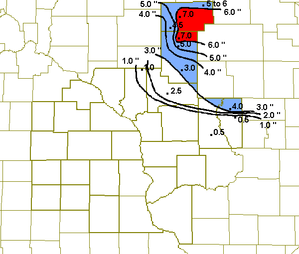
ZCZC MKEPNSLSE
ABUS34 KLSE 212123

PUBLIC INFORMATION STATEMENT
NATIONAL WEATHER SERVICE LA CROSSE WI
422 PM CDT MON OCT 21 2002

SNOW EVENT TOTALS ACROSS THE AREA THROUGH 4 PM

LOCATION                   COUNTY              SNOWFALL(IN)

...WISCONSIN...
PERKINSTOWN 5E             TAYLOR                  7.0
LUBLIN                     TAYLOR                  4.5
RIB LAKE                   TAYLOR                  5 TO 6
GAD                        TAYLOR                  6.0
WITHEE                     CLARK                   7.0
LONGWOOD                   CLARK                   5.0
NEILLSVILLE                CLARK                   3.0
BIG FLATS                  ADAMS                   4.0
NEW ROME                   ADAMS                   1 TO 2
FRIENDSHIP 10 NE           ADAMS                   0.5
BLACK RIVER FALLS 2 SE     JACKSON                 2.5
MAUSTON                    JUNEAU                  0.5
OSSEO                      TREMPEALEAU             1.0

$$

NNNN


 Weather Story
 Weather Map
 Local Radar