Summary
During July 2021, temperatures averaged near-normal & rainfall was highly variable across the Upper Mississippi River Valley.
Monthly average temperatures for July ranged from 65.5°F at Medford, WI to 75.4°F at La Crosse Regional Airport. In most locations, July (typically our hottest month of the year) was slightly cooler than June. This has only occurred 11 times since the early 1870s. The last time was 2014. The hottest temperature was 96°F just south of Theilman, MN on July 6, and the coldest temperature was 42°F at Sparta Fort McCoy Airport on July 11.
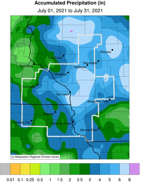
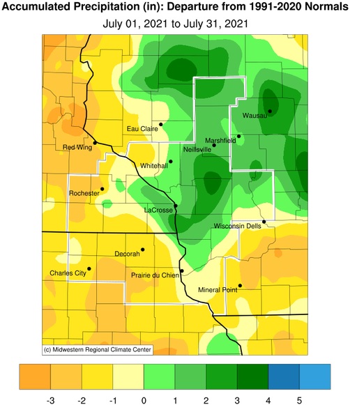
Like May & June, the July 2021 rainfall was highly variable across the Upper Mississippi River Valley. Rainfall totals ranged from 2.09” just west of Ionia, IA to 8.61” near Warrens, WI. The driest areas continued to be found in southeast Minnesota, northeast Iowa, and southwest Wisconsin where rainfall deficits were 1 to 3". Meanwhile, areas along and north of Interstate 90 in Wisconsin saw rainfall surpluses up to 3". Typically, the July rainfall is around 4" north of Interstate 94 and ranges from 4 to 5" across the remainder of the region.
Flood Conditions
While there was no river flooding observed at the forecast points, there were a couple of Urban and Small Flood Advisories issued for heavy rain during the month. They were issued on the evening of July 14 for southeastern Houston County in southeast Minnesota and central Vernon County in southwest Wisconsin, and during the overnight of July 28-29 for south-central La Crosse County in west-central Wisconsin.
River Conditions
During July 2021, the average 7 AM stage for the Mississippi River at La Crosse WI was 4.93 feet. This was the lowest average stage for a July since 2009 (4.79 feet). The average July stage (1938-2021) is 6.24 feet. However, during the past decade, we have averaged 7.92 feet. The lowest average July stage was 4.51 feet in 1964. Much of the reason why the Mississippi River has been so low is due to the moderate (D1) to extreme (D3) drought in the Minnesota and St Croix river watersheds.
Elsewhere, streamflows ranged from below- to near-normal for northeast Iowa and southeast Minnesota, and from near to above-normal in southwest and central Wisconsin.
Drought
During much of July 2021, abnormally dry (D0) to severe (D2) drought was seen in northeast Iowa, southeast Minnesota, and southwest Wisconsin. Elsewhere, it ranged from no drought to moderate (D1) drought. By the end of the month, moderate (D1) and severe (D2) drought covered 56.03% of the La Crosse Hydrologic Service Area (HSA), and another 29.1% was abnormally dry (D0).
 |
 |


 Weather Story
 Weather Map
 Local Radar