| Temperatures | Precipitation | ||||||
| Month | High | Low | Average | Departure | Total | Departure | Snow |
| January | 22.9 | 5.9 | 14.4 | +2.9 | 1.76 | +0.98 | 19.3 |
| February | 34.6 | 17.9 | 26.3 | +9.2 | 0.99 | +0.25 | 7.0 |
| March | 49.1 | 29.4 | 39.3 | +9.5 | 0.87 | -0.91 | 3.3 |
| April | 56.9 | 34.3 | 45.6 | +0.7 | 0.94 | -1.79 | 2.1 |
| May | 69.1 | 48.6 | 58.9 | +2.1 | 7.37 | +3.97 | T |
| June | 74.1 | 54.9 | 64.5 | -2.0 | 12.52 | +8.80 | ... |
| July | 77.8 | 61.0 | 69.4 | -1.5 | 5.56 | +1.36 | ... |
| August | 78.0 | 59.9 | 69.0 | +0.8 | 5.25 | +1.37 | ... |
| September | 70.8 | 48.9 | 59.9 | +0.7 | 1.04 | -2.43 | ... |
| October | 61.8 | 41.5 | 51.7 | +3.8 | 1.65 | -0.67 | T |
| November | 35.9 | 24.1 | 30.0 | -2.6 | 3.06 | +1.45 | 5.4 |
| December | 13.3 | -1.1 | 6.1 | -11.1 | 1.64 | +0.61 | 35.3 |
| TOTALS: | 53.7 | 35.4 | 44.6 | +0.8 | 42.65 | +13.75 | *** |
Records
Temperature...
Highs:
Lows:
Highest Lows:
Lowest Highs:
Monthly:
Seasonal:
Yearly:
Precipitation...
One-day pcpn:
One-day snowfall:
Monthly pcpn:
Monthly snowfall:
Seasonal precipitation:
Yearly precipitation:
|
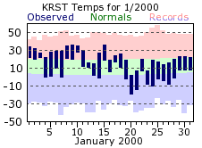
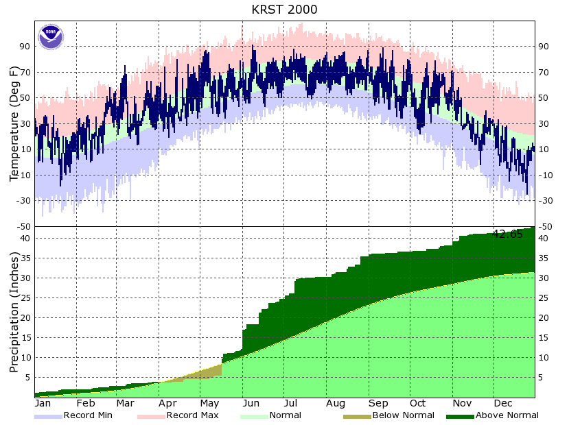
What has become a common occurrence over the last few years, the year 2000 started out on a mild note. Temperatures were at or above normal for the first half of January, with the first below zero readings of the new year holding off until the 14th. Colder air then settled in for the last half of the month, with the coldest day of the month occurring on the 20th at 19 below zero. Snowfall for the month was above normal, thanks mostly to two days. On the 2nd, 6 inches of snow was recorded, with another 6.8 inches falling on the 19th. Those two days accounted for 87% of the monthly total, which turned out to be the 9th snowiest January on record.
|
 |
|
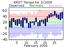
February was a very mild month, finishing as the 8th warmest February along with setting several other daily high temperature records. Temperatures never fell below zero, while the 50 degree barrier was broken on the 23rd, 25th, 28th, and 29th. The average high temperature for Rochester doesn’t reach 50 until the beginning of April. Snowfall for the month was normal, but what did fall did not last long due to the very mild conditions.
|
 |
|
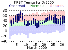
March got the “spring” months off to a “summer” like start. High temperatures not only climbed to 60 degrees by the 4th, but reached 75 on the 7th! The stretch of March 4th through the 8th all set new record highs. Temperatures finally cooled a bit by mid-month, but still ended with mild conditions. Temperatures were below average only 5 times in March, helping to tie it for the 3rd warmest March in Rochester.
|
 |
|
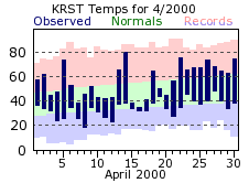
There weren’t many “April showers” to bring “May flowers” this past April. Total precipitation for the month was almost two inches below normal, with over half of the total coming on the 19th and 20th. The last measurable snow of the 1999-2000 season came on the 11th of the month, with one-half inch falling.
|
 |
|
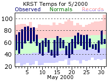
May brought the start of a very wet trend to the area, finishing 4 inches above normal! Accumulating rains fell on 16 days, which is 5 days more then usual. However, most of the precipitation for May came in one chunk, with 4.02 inches falling on the 17th. That day amounted for 55% of May’s total. With the May temperatures also averaging above normal, it continued a mild trend that has persisted across the area for the last couple years. In fact, temperatures through this May averaged below normal with regard to temperatures only 6 times since January of 1998. That is a span of 29 months. This trend would change for the rest of 2000 though.
|
 |
|
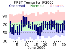
June was the wettest month of 2000, with over 12 ½ inches falling. Unlike other months where the majority of the monthly total fell on a day or two, June’s total was spread throughout the month. There were 4 days of an inch or greater, with 5 more days of a tenth or more. The area did get a good soaking from the 13th through the 15th, with nearly 4 inches falling over that span. However, that is still below the deluge that occurred on the 1st when 4.81 inches were recorded. That was the highest one-day total for the year, and also the 5th wettest day all-time. The unusually wet conditions also helped keep temperatures down, with June winding up a bit below normal. Yet, June managed the only 90 degree or better day for the year when mercuries reached 91 on the 8th.
|
 |
|
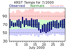
July also finished above normal for rainfall, by nearly 1 ½ inches. However, the rain was confined to the beginning of the month. Rochester endured a long dry stretch, with only around 1/4 inch of rain after the 12th. Temperatures also stayed below normal for the second consecutive month.
|
 |
|
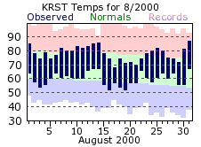
The faucet would stay open for August, with another 5 plus inches falling for the month. This would bring the summer total (June, July and August) to 23.33 inches, which set the all-time record for wet summers for Rochester. Temperatures were near normal, with no drastic swings warm or cold.
|
 |
|
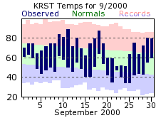
September usually experiences a lot of “ups and downs” when it comes to temperatures, as it transitions from summer to fall. This past September was no different, with a high for the month of 89 degrees on the 11th, and a low 34 on the 24th and 25th. The cold temperatures wouldn’t stay for long though, with more mild conditions by month’s end. September was also a very dry month, finishing more then 2 inches below normal and ending the string of 4 consecutive wet months. Accumulating rains only fell 7 times during the month.
|
 |
|
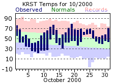
Temperatures were, more or less, flip-flopped for the month of October. Colder, below normal readings started out the month, with milder readings by mid-month and continuing through the 31st. It started out a bit chilly with temperatures not climbing out of the 40s for highs on the 6th through the 8th. Warm weather wasn’t totally gone though, as mercuries approached 80 one more time on the 19th, reaching 79 degrees. Rainfall was below normal for the 4th and last time of 2000.
|
 |
|
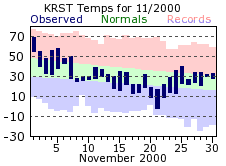
The warmest day of November occurred on the 1st, when the high reached 69 degrees. After that, conditions made a emphatic u-turn with cooler temperatures. In fact, after the 1st, high temperatures did not make it out of the 30s on 22 days. Meanwhile, lows stayed at or below freezing from the 7th on. The first below zero day of the new winter season was also recorded in November, with a -2 reading on the 21st. This would be a harbinger of things to come.
|
 |
|
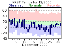
December was easily the most interesting month of the year, bringing some of the most significant weather, especially considering the very mild winters of the previous few years. Not only was December cold, it was significantly colder and ended up being the 2nd coldest December on record. Temperatures were only at or above freezing on one day, the 4th, and never even reached 10 degrees on 12 days. Also, low temperatures sank to or below zero on 18 days, double the normal of 9 for December. Not to be out done, the 11th, 12th, 21st, 22nd, and 24th never saw temperatures above zero for the entire day. The coldest day of the year was on Christmas morning, with old Saint Nick having to deal with a -25 degree reading. The cold wasn’t the only weather story for the month. Old Man Winter not only made up for the recent mild Decembers in dramatic fashion, but also the lack of snowfall. The 8.1 inches that fell on the 28th bettered the total for all of last December (7.6 inches in 1999). Measurable snow fell 17 times with the Rochester area never going more then 4 days in a row without needing to shovel. The total of 35.3 inches for the month made it not only the snowiest December on record, but the snowiest month all-time! To add even more perspective to the significant snowfall, December’s total nearly equaled the total for the entire 1999-2000 snowfall season of 39.8 inches.
|
 |
 |
| Highest temperature for 2000 | 91 on June 8th |
| Lowest temperature for 2000 | -25 on December 25th |
| Highest one-day precipitation | 4.81 on June 1st |
| Highest one-day snowfall | 8.1 inches on December 28th |
| Number of days with highs at or above 90 degrees | 10 |
| Number of days with highs at or below 32 degrees | 88 |
| Number of days with zero or below temperatures | 32 |
| Peak wind gust | |
| Number of days with measurable precipitation | 136 |
| Percentage of days with measurable precipitation | 37% |
| Number of days with above normal temperatures | 194 |
| Percentage of days with above normal temperatures | 53% |


 Weather Story
 Weather Map
 Local Radar