| Temperatures | Precipitation | ||||||
| Month | High | Low | Average | Departure | Total | Departure | Snow |
| January | 21.6 | 5.5 | 13.5 | -1.7 | 0.31 | -0.63 | 5.7 |
| February | 25.1 | 4.7 | 14.9 | -3.5 | 0.65 | -0.10 | 6.4 |
| March | 40.2 | 21.6 | 30.9 | +0.3 | 2.28 | +0.40 | 6.0 |
| April | 55.8 | 35.2 | 45.5 | +0.8 | 2.54 | -0.47 | 6.4 |
| May | 65.8 | 44.8 | 55.3 | -1.6 | 4.65 | +1.12 | 0.0 |
| June | 76.0 | 54.8 | 65.4 | -0.7 | 4.75 | +0.75 | ... |
| July | 79.2 | 59.9 | 69.5 | -0.6 | 3.39 | -1.22 | ... |
| August | 81.7 | 59.8 | 70.8 | +3.1 | 0.34 | -3.99 | ... |
| September | 71.9 | 47.3 | 59.6 | +0.7 | 1.58 | -1.54 | ... |
| October | 60.3 | 36.9 | 48.6 | +1.6 | 0.52 | -1.68 | T |
| November | 39.3 | 24.7 | 32.0 | +0.8 | 1.00 | -1.68 | 1.3 |
| December | 31.3 | 17.4 | 24.3 | +7.0 | 1.35 | +0.33 | 12.3 |
| TOTALS: | 54.0 | 34.4 | 44.2 | +0.8 | 23.36 | -8.04 | *** |
Records
Temperature...
Highs:
Lows:
Highest Lows:
Lowest Highs:
Monthly:
Seasonal:
Yearly:
Precipitation...
One-day pcpn:
One-day snowfall:
Monthly pcpn:
Monthly snowfall:
Seasonal precipitation:
Yearly precipitation:
|
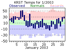
January got 2003 off to a mild start, with two record high temperatures being set on the 7th and 8th. Temperatures would fall off to the seasonable normals by mid month however, and continue that trend for the rest of the month. It was a rather dry for the most part, with under 1/10 of an inch of liquid equivalent precipitation through the first 26 days, and only one-third of an inch total. January is usually the snowiest month of the year, but wasn’t in 2003. A total of 5.7 inches fell, mostly coming over the last 5 days of the month.
|
 |
|
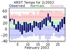
February temperatures felt more like a typical January, and averaged 3 ½ degrees below normal. The coldest temperature of the year occurred on the morning of the 7th, when mercuries fell to 17 below. It was another dry month, with the bulk of the precipitation falling in the first half of the month. The 6.4 inch snow total tied April for the snowiest month of the 2002-03 winter season. The snow was spread out, with 4 days recording just over an inch.
|
 |
|
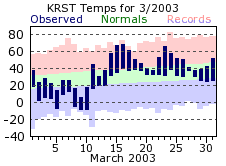
The average temperature for the month of March was right around its normal, but there was a lot of day to day variability. The start of the month was rather chilly, with lows falling below zero 4 times. Within a week of the last below zero reading of the 2002-03 winter however (-9 on the 10th), high temperatures nearly reached the 70 degree mark (68 on the 16th). March had more than double the amount of precipitation of both January and February combined, and finished almost ½ inch above normal. The bulk of this precipitation fell as rain (most coming on the 27th with 1.30 inches), although the month still recorded 6 inches of snow.
|
 |
|
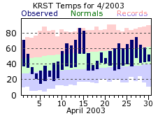
April ran the gambit of temperatures, which is typical for this spring month. The month began with a 71 degree reading, but highs then failed to reach freezing on the 4th and 5th. By the 14th, some might have mistaken it for July, as temperatures shot up to 87 degrees, setting a new record for that day. April was another dry month, finishing ½ inch below normal. In addition, most of the rain that fell came on the 16th, and over the 18th and 19th. These three days accounted for three-fours of the total. There was some significant snowfall during April though, with a spring storm dropping 5 ½ inches on the 7th. This was also the largest one-day snow total for the 2002-03 winter.
|
 |
|
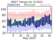
May was a cool month, with mercuries not climbing back to 80 until the 27th, and only 11 days with above normal temperatures. It was also one of the wettest months of the year, finishing over an inch above normal. The wettest stretch of the month was from the 4th through the 14th, when rain fell on everyday but the 12th. This string of days accounted for nearly the entire month’s total (98%). The windiest day of the year, on average, occurred on the 11th of this month. Wind speeds on that day averaged 27.7 mph.
|
 |
|
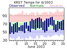
June got the traditional summer months off to a cool start, with below normal temperatures for 11 out of the first 12 days. Seasonable temperatures returned for the later half of the month. June was another wet month, which would turn out to be a rarity for 2003. The rainfall was fairly spread out, with 5 days recording ½ inch of more.
|
 |
|
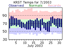
July was slightly below normal for temperatures, but fairly consistent day to day, without any major swings hot or cold. Highs failed to warm to 90 degrees or better though, which usually occurs 3 to 4 times in a July. The start of the month was wet, with 8 straight days of measurable rain (the 4th through the 11th). However, the 2.88 inches recorded over that time would be 85% of the monthly total. Only around ½ inch would fall the rest of the month.
|
 |
|
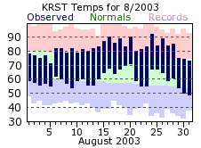
August was the hottest month of 2003, easily outdistancing July, which is normally the hottest. There was one significant stretch of heat at mid month, with temperatures topping out at 90 degrees or greater 3 times. The hottest day of the year would occur on the 24th, with 92 degrees. The area was well into a drought by the time August started, and the mere 1/3 of an inch of rain during August did little to alleviate it. This 4 inch deficit helped the 2003 August become the second driest on record for Rochester. Measurable rainfall fell on only 4 days in the month, well below the usual 10 such days.
|
 |
|
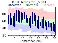
September was a tale of two halves, with the first part of the month continuing the summer warmth, then a quick transition to fall conditions for the last part. Two days of 90 degree or better heat effected the area on the 6th and 7th, with some 80 degree readings still occurring through mid month. However, the last week of September saw high temperatures tumble into 50s, with lows dropping below the freezing mark on the 29th and 30th. Another below normal month for rainfall continued the dire drought conditions. Nearly all of September’s total fell on the 18th (1.26 inches), which left 24 of the 30 days with a trace of less of rainfall.
|
 |
|
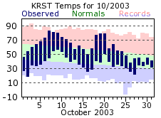
October would be the 4th straight month with below normal precipitation, with a total deficit over that time of nearly 8 ½ inches. The first flurries of the new snowfall season would occur this month though, with a few flakes falling on the 25th. Temperatures were above normal for the third straight month, but fluctuated greatly day to day. Temperatures dropped to a chilly 19 degrees on the 2nd, with highs then jumping to 80 or greater for the 7th through the 9th. High would again approach 80 by mid month, before settling back to seasonably cool 40 degree readings for the last week of October.
|
 |
|
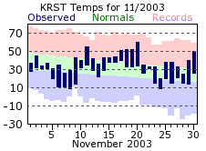
November was rather uneventful on the whole, averaging near normal temperatures with no significant cold or warm spells. Precipitation was below normal again though, by an inch. What precipitation did fall came in the form of “a tenth of an inch here, and a tenth there”. While this did not bring much relief to the drought conditions, it did not make them any worse. Temperatures did reach a monthly high of 60 on the 20th, dropping off to a high of 20 on the 24th. And one last gasp of fall came on the 30th, with highs reaching 50 degrees. The first measurable snowfall of the new winter season occurred on the 3rd, with a 0.8 inches being recorded.
|
 |
|
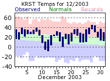
December was the 5th straight month which averaged near or above normal temperatures. Like November though, there were no significant swings in temperature. Rochester did manage to dip below zero for lows on the 11th and 12th. This was their first below zero readings of the new winter season. For the first time since June, precipitation was above normal. However, it was only a 1/3 of an inch. This made just a small dent in the mounting precipitation deficits which began in July. Snowfall was nearly 2 inches (1.9 inches) above normal for the month, thanks in large part to a storm system that dropped 6.5 inches on the 9th and 10th. Also, despite a warm up around the Christmas holiday, enough snow cover remained for a "white" Christmas. White Christmases usually occur in 8 out of every 10 years, with 2002 being the last non‑"white" Christmas.
|
 |
 |
| Highest temperature for 2003 | 92 on August 24th |
| Lowest temperature for 2003 | -17 on February 7th |
| Highest one-day precipitation | 1.53 inches on May 4th |
| Highest one-day snowfall | 5.5 inches on April 7th |
| Number of days with highs at or above 90 degrees | 5 |
| Number of days with highs at or below 32 degrees | 82 |
| Number of days with zero or below temperatures | 33 |
| Peak wind gust | 52 mph from the northwest on November 12th |
| Number of days with measurable precipitation | 114 |
| Percentage of days with measurable precipitation | 31% |
| Number of days with above normal temperatures | 185 |
| Percentage of days with above normal temperatures | 51% |

