| Temperatures | Precipitation | ||||||
| Month | High | Low | Average | Departure | Total | Departure | Snow |
| January | 20.9 | 6.4 | 13.6 | +1.8 | 0.67 | -0.27 | 13.0 |
| February | 21.4 | 5.1 | 13.3 | -5.1 | 0.56 | -0.19 | 7.3 |
| March | 36.0 | 21.0 | 28.5 | -2.1 | 1.58 | -0.30 | 9.0 |
| April | 53.0 | 35.2 | 44.1 | -0.6 | 4.17 | +1.16 | 0.8 |
| May | 67.3 | 45.0 | 56.2 | -0.7 | 3.47 | -0.06 | T |
| June | 77.9 | 58.3 | 68.1 | +2.0 | 7.15 | +3.15 | ... |
| July | 81.7 | 60.7 | 71.2 | +1.1 | 3.21 | -1.40 | ... |
| August | 79.2 | 57.8 | 68.5 | +0.8 | 1.92 | -2.41 | ... |
| September | 72.8 | 52.3 | 62.6 | +3.7 | 1.75 | -1.37 | ... |
| October | 60.2 | 38.9 | 49.6 | +2.6 | 2.45 | +0.25 | 0.1 |
| November | 42.2 | 27.0 | 34.6 | +3.4 | 2.34 | +0.33 | 4.4 |
| December | 22.9 | 2.1 | 12.5 | -4.8 | 1.52 | +0.50 | 28.6 |
| TOTALS: | 53.0 | 34.2 | 43.6 | +0.1 | 30.79 | -0.61 | *** |
Records
Temperature...
Highs:
Lows:
Highest Lows:
Lowest Highs:
Monthly:
Seasonal:
Yearly:
Precipitation...
One-day pcpn:
One-day snowfall:
Monthly pcpn:
Monthly snowfall:
Seasonal precipitation:
Yearly precipitation:
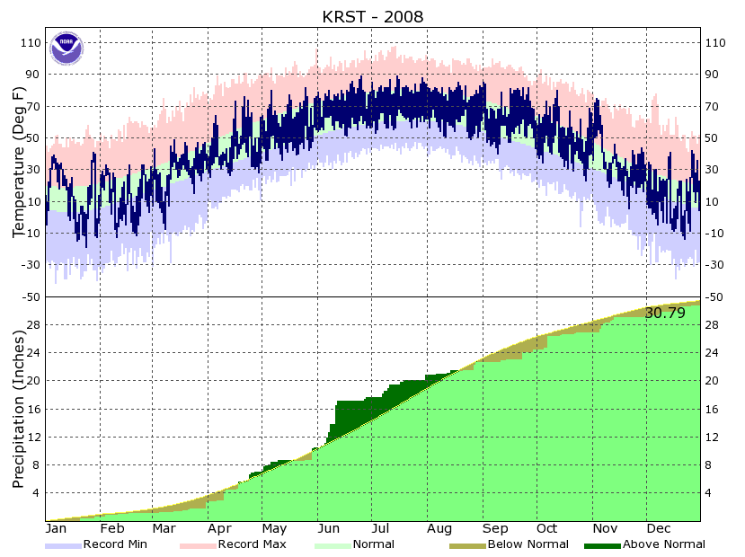
| The new year started off cold, but mild air quickly returned, with well above normal temperatures for the 4th through 13th as lows were closer to the average highs rather than the lows for early January. The warm up wouldn’t last though, as cold Canadian air flowed back into the region, setting up residence for much of the rest of the month. Below zero lows were recorded on 12 of the last 18 days, with temperatures never climbing above zero on the 19th and 30th. Despite the cold snap, average temperatures for the month finished above normal. Snowfall was a bit above normal for the month, with nearly all the measurable snow falling on 4 days. The snowiest day was the 21st, when 5.5 inches fell. This would also prove to be the snowiest one-day total for the 2007-8 winter season. The windiest day, on average, for 2008 would occur this month. Wind speeds averaged 27.1 mph on the 29th (gusts up to 47 mph), which when combined with falling snow and accumulations of 3.5 inches, resulted in blizzard conditions for a short time. | 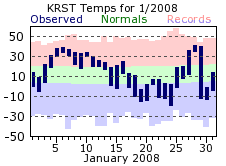 |
|
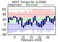
February started off mild, but temperatures would tumble after the first week. After the 6th, below normal temperatures were recorded on 19 of the remaining 23 days (including leap day). February also brought a day where temperatures could not crack zero, with a high of only -4 on the 10th. Snowfall for the month was right around the monthly average, and fell fairly uniformly throughout the month. There were 9 days with measurable snowfall, most coming in the form a few tenths to around ½ inch. |
 |
|
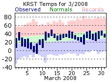
The cold air hung in place for the beginning of March, but more seasonable air would return by the 11th, and then persist through month’s end. The last below zero days of the winter would come on the 7th and 8th, with the low of -8 on the 8th setting a record for that day. Like February, the March snowfall was right around its normal and fairly spread out. There were 10 days with measurable snowfall, with most dropping less than an inch. |
 |
|
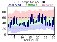
April was a pretty average month for temperatures, finishing about ½ degree below its normal. There were big swings in the temperature though, with highs varying as much as 20 degrees from one day to the next. This is not out of the ordinary for this spring month, as the weather pattern starts to shift from winter to summer, resulting in what can be a roller coaster ride from warm to cold to mild to cool temperatures. The last freezing day of the winter season occurred in April, with a reading of 28 degrees on the 29th. While not a very snowy month on average, this past April received less than an inch, with a few tenths here and there through the first couple weeks. The last measurable snow for the 2007-08 winter season would fall on the 12th. January may have had the windiest day of 2008, but on the whole, April was the windiest. This is expected though, as April is usually the windiest month in Rochester. |
 |
|
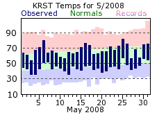
Rainfall for May was right around the monthly normal, with 12 days of measurable precipitation accounting for the 3.47 inches. However, almost 50% of the monthly total occurred on the 29th (1.55 inches), with the 2nd and 6th accounting for an inch between them. A few flurries flew on the 3rd, the last time snow would be seen in 2008 until October. Temperatures averaged just a bit below normal for May, and aside from a couple 20 degree swings in the highs near the end of the month, temperatures were rather consistent. |
 |
|
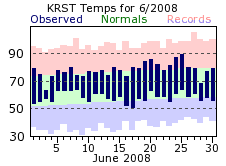
June got the summer months off to a very wet start, with over 6 ½ inches of the monthly total falling in the first 12 days. The 11th was the wettest day of the period, and the year for the matter, with 2.79 inches falling. It was not a record for the day though. Drier conditions settled in for the rest of the month, with only 2 days of measurable rainfall over the last 18 days (0.47 inches fell over the 27th and 28th). June temperatures averaged above normal, but there were no significant warm stretches as daily temperatures were a bit above or near the monthly normals. |
 |
|
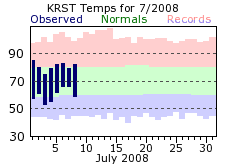
July was drier, although still had its share of rain, with 5 days recording around ½ inch or greater. Unlike June, the rainfall was better distributed throughout the month, although there was an 11 day stretch where only 0.03 inches fell (20th through the 30th). Temperatures averaged a bit above normal, but again, there were no significant warm periods as temperatures were pretty consistent day to day. Highs even failed to crack the 90 degree barrier, which usually happens 3 times in a typical July. |
 |
|
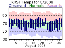
As was the case for the other two summer months, temperatures for August averaged a bit above normal, but without any appreciable warm-ups as day to day consistency won out again. The 90 degree barrier remained untouched, and would for the rest of 2008. August was a dry month, finishing almost 2 ½ inches below the monthly normal. What little that did fall would come in bunches, with 3 days accounting for 80% of the 1.92 total for the month. |
 |
|
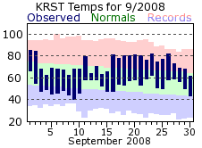
September would mark the 4th consecutive month with below normal precipitation. The 23rd brought the bulk of the rain, with 60% of the 1.75 inch total falling on that day. It was a fairly cool start to the month, with high temperatures only in the 60s for 11 out of the first 15 days. After that, warmer air would return, with highs popping into the 80s six times. This warm end to the month helped September finish with warmer than normal temperatures for the month. |
 |
|
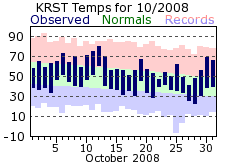
Temperatures for October averaged above normal for the 5th consecutive month, but unlike the other months, there was more variance day to day. For instance, a string of highs in the 70s at mid month fell off into the 50s for a week after that. Meanwhile, highs chilled into the 40s toward the end of the month, only to warm back into the 60s for the 30th and 31st. After a few dry months, rainfall was closer to the norm for October. However, 2/3rds of 2.45 inch total came on the 7th, with a daily record of 1.62 inches falling. There were 10 more day of measurable rainfall, but nearly all were 1/10 of an inch or less. The first snowfall of the new winter season came on the 26th, with a 1/10 of an inch falling, while the first freeze occurred on the 16th. |
 |
|
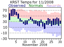
Temperatures more fitting of mid September greeted the first week of November as highs approached, or exceeded, 70 degrees. The warmth would not last long, as air more suitable for the season returned by the 7th, sticking around through month’s end. Still, the very warm start helped the month finish a few degrees above normal. Measurable snow fell on 9 days in November, but generally only a few tenths at a time. The monthly total of 4.4 inches was a bit below the monthly normal. |
 |
|
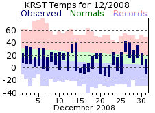
Snowy would be the easiest way to describe December, as at least a trace or more fell on 23 out of the 31 days. Measurable snow fell on 15 days, with 8 of those recording an inch or more. This is well above the normal of 3 such days. The biggest snow event of the month came on the 19th and 20th, with 12.4 inches falling over these two days. The grand total of 28.6 inches made it the 3rd snowiest December on record, and the 6th snowiest out of all months. If not for the appreciable snowfall, cold would be the defining word for December 2008. Aside from two brief warm-ups, a steady supply of arctic air kept temperatures below normal. One of those short warm-ups was more notable for the dramatic change in temperature rather than for a high above 40 degrees. On the 14th, highs reached 41 in Rochester, but as an arctic cold front swept through that afternoon, temperatures dropped 20 degrees in two hours! By the morning of the 15th, lows had bottomed out at -8, resulting in a 49 degree diurnal change between the high and low temperature. |
 |
|
Overall, 2008 was an average year on the whole, with temperatures and precipitation right around the normal. Considerable snowfall in the early part of the year would return for the end, with record setting snows falling in December. Meanwhile, a dry period was experienced from mid summer into early fall. After a somewhat cool start to the year, milder air moved in for the second half of 2008, especially during the fall. The year would end chilly though, with arctic air keeping December well below normal. |
 |
| Highest temperature for 2008 | 89 on June 25th and July 15th |
| Lowest temperature for 2008 | -19 on January 24th |
| Highest one-day precipitation | 2.79" on June 11th |
| Highest one-day snowfall | 7.0" on December 20th |
| Number of days with highs at or above 90 degrees | 0 |
| Number of days with highs at or below 32 degrees | 88 |
| Number of days with zero or below temperatures | 42 |
| Peak wind gust | 61 mph from the west on July 31st |
| Number of days with measurable precipitation | 127 |
| Percentage of days with measurable precipitation | 35% |
| Number of days with above normal temperatures | 183 |
| Percentage of days with above normal temperatures | 50% |


 Weather Story
 Weather Map
 Local Radar