Overview
|
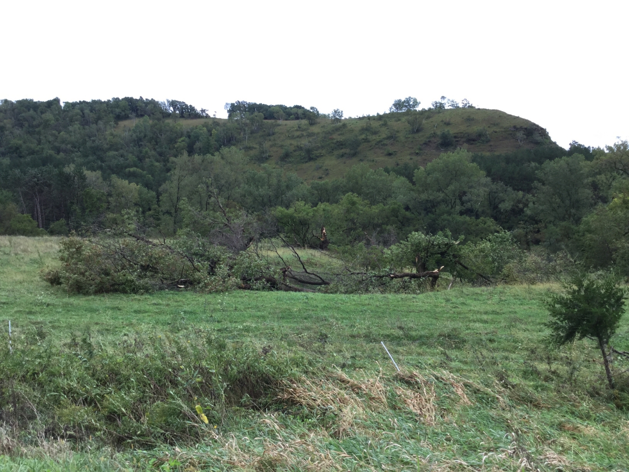
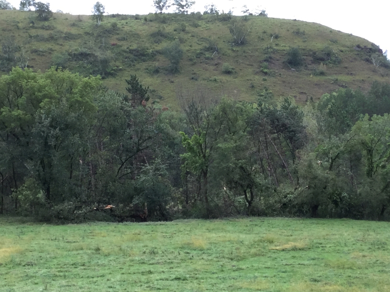
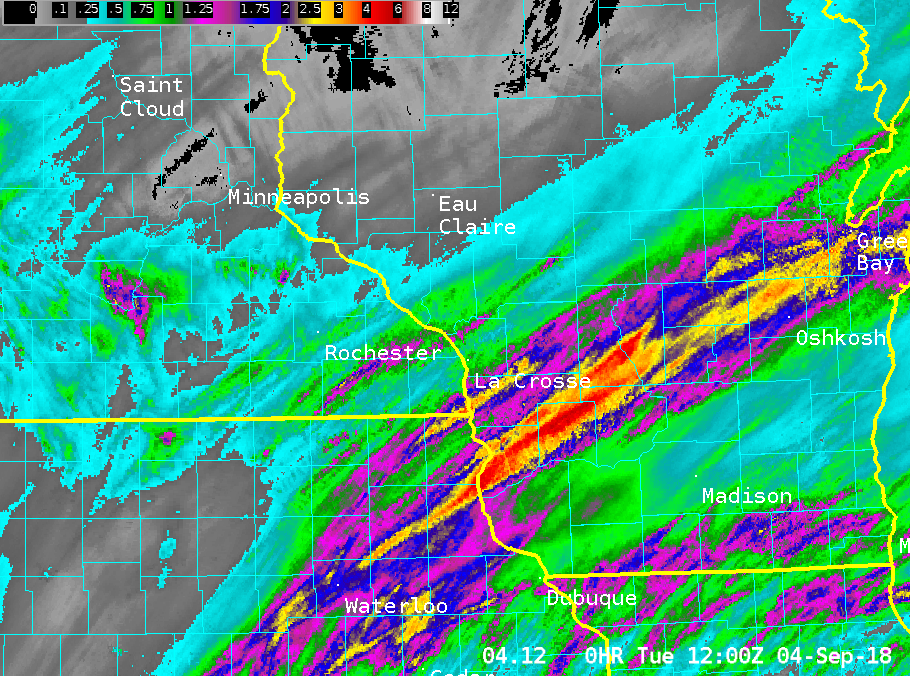
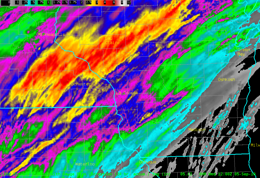
Widespread showers and thunderstorms, over a 2-day period, brought heavy rain and other severe weather to the region on Monday, Sept. 3rd and Tuesday, Sept. 4th, continuing into the morning hours of Wednesday, Sept. 5th. The heaviest rain Monday into Tuesday fell over northeast Iowa into southwest Wisconsin. The next day and night, the heaviest rain fell Tuesday evening into Wednesday morning. Rainfall rates were 2-3 inches per hour at times. Widespread street and other urban flooding occurred, along with rapid rises on area rivers and streams. Some area rivers climbed back into MAJOR flood stage from flooding the week before, and other rivers approached flood stage for the first time through the active pattern. Rock and mudslides were reported in some of the hilly locations, and there were numerous road closures (especially in southwest Wisconsin). There was also sporadic wind damage and one tornado (EF-1) as the storms moved through. |
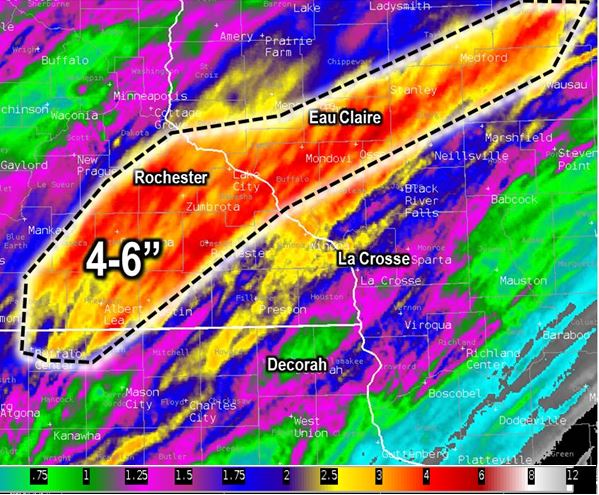 24 hour rainfall through 6 am Sep 5, 2018 |
Tornado:
|
Tornado - Hart, MN
Track Map 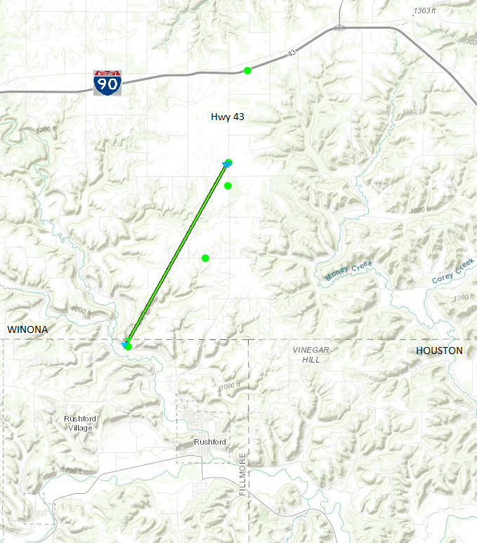  |
||||||||||||||||
The Enhanced Fujita (EF) Scale classifies tornadoes into the following categories:
| EF0 Weak 65-85 mph |
EF1 Moderate 86-110 mph |
EF2 Significant 111-135 mph |
EF3 Severe 136-165 mph |
EF4 Extreme 166-200 mph |
EF5 Catastrophic 200+ mph |
 |
|||||
Flooding
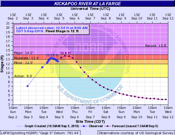
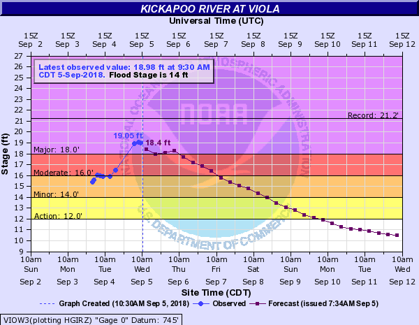
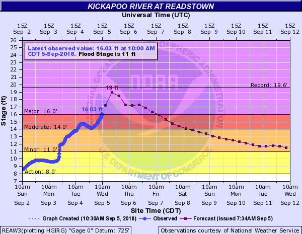
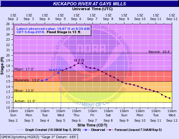
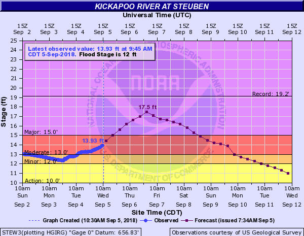
Hydrographs
 |
 |
 |
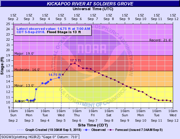 |
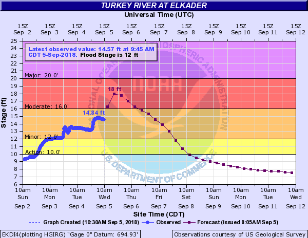
| Kickapoo River at La Farge, WI | Kickapoo River at Viola, WI | Kickapoo River at Readstown, WI | Kickapoo River at Soldiers Grove, WI |
 |
 |
 |
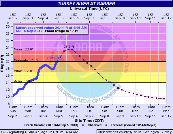 |
| Kickapoo River at Gays Mills, WI | Kickapoo River at Steuben, WI | Turkey River at Elkader, IA | Turkey River at Garber, IA |
Photos:
 |
 |
 |
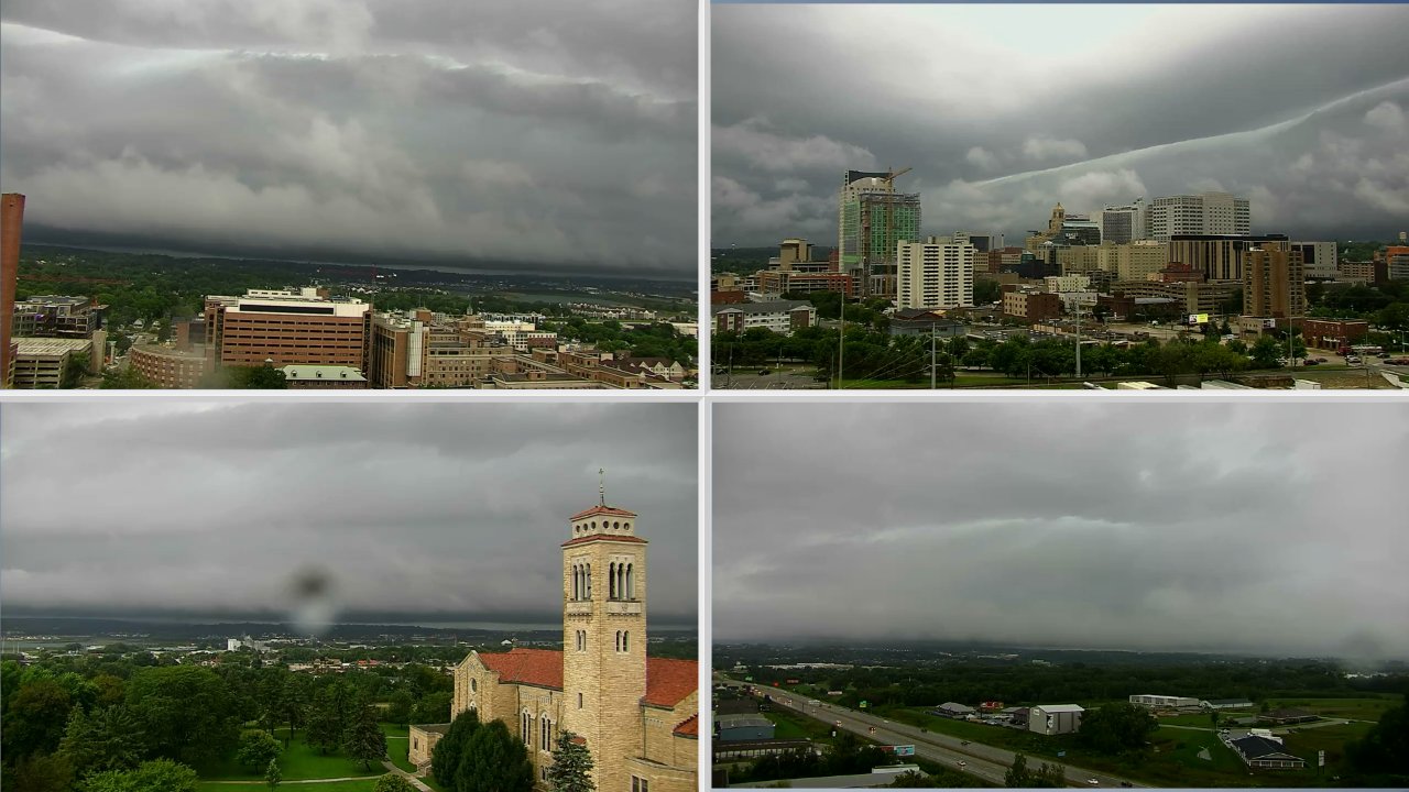 |
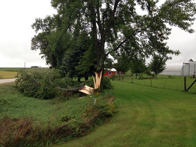
| Tornado damage northwest of Rushford, MN (Photo by NWS Survey) | Tornado damage northwest of Rushford, MN (Photo by NWS Survey) | Storm damage to yard near Hwy.43 (Winona Co.) (Photo by NWS Survey) | Shelf cloud photos from Rochester (Photos by Matt Benz/KTTC) |
 |
 |
 |
 |
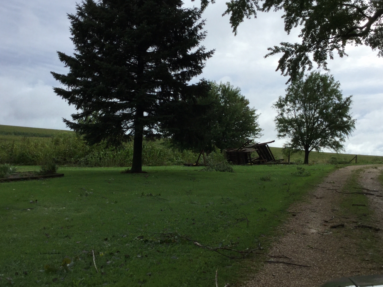
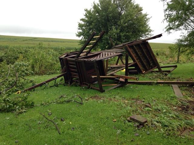
| Tornado damage - Town of Hart, MN (Photo by Winona Co. Emerg.Mgmt) |
Tornado damage - Town of Hart, MN (Photo by Winona Co. Emerg.Mgmt) |
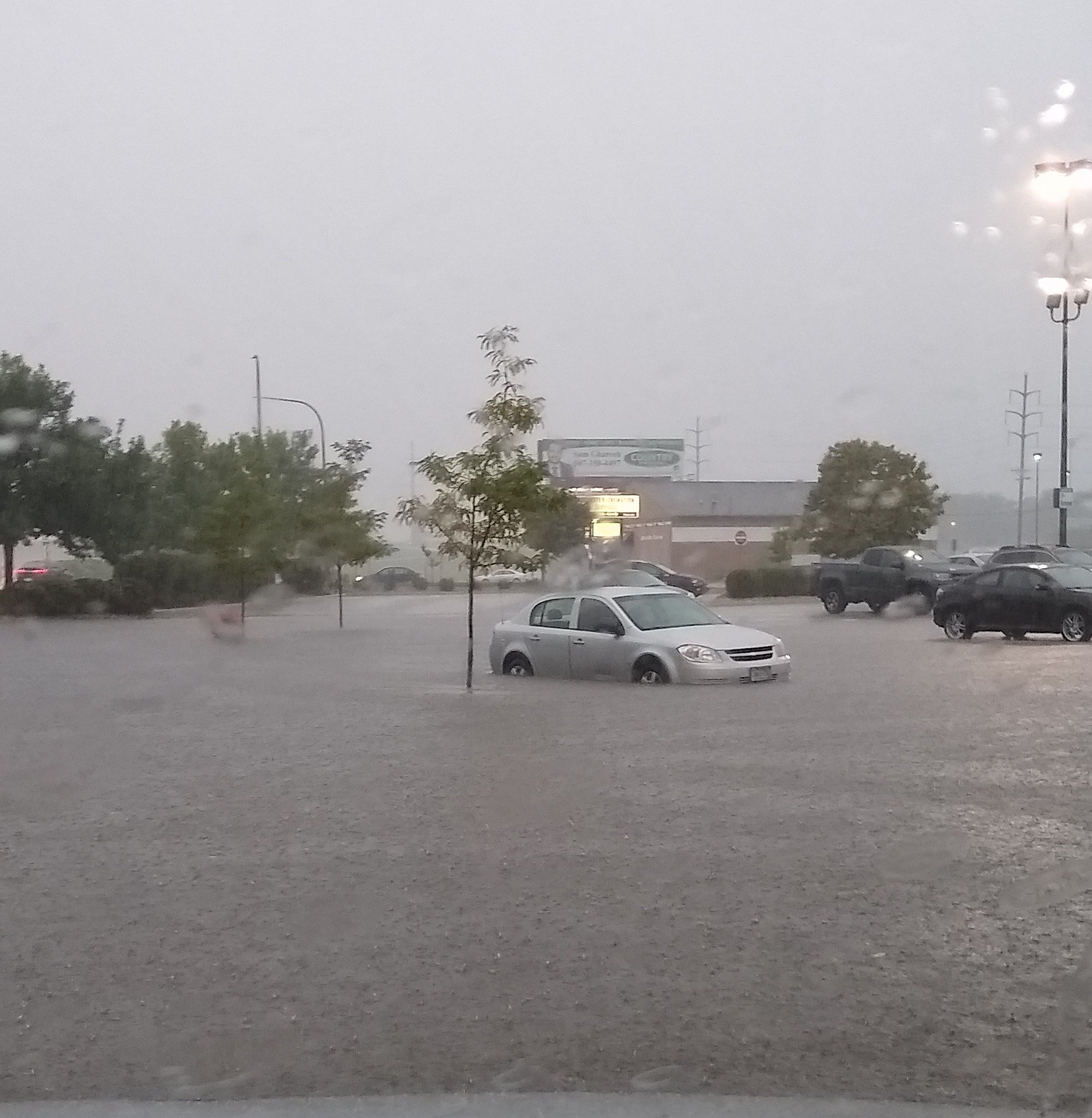
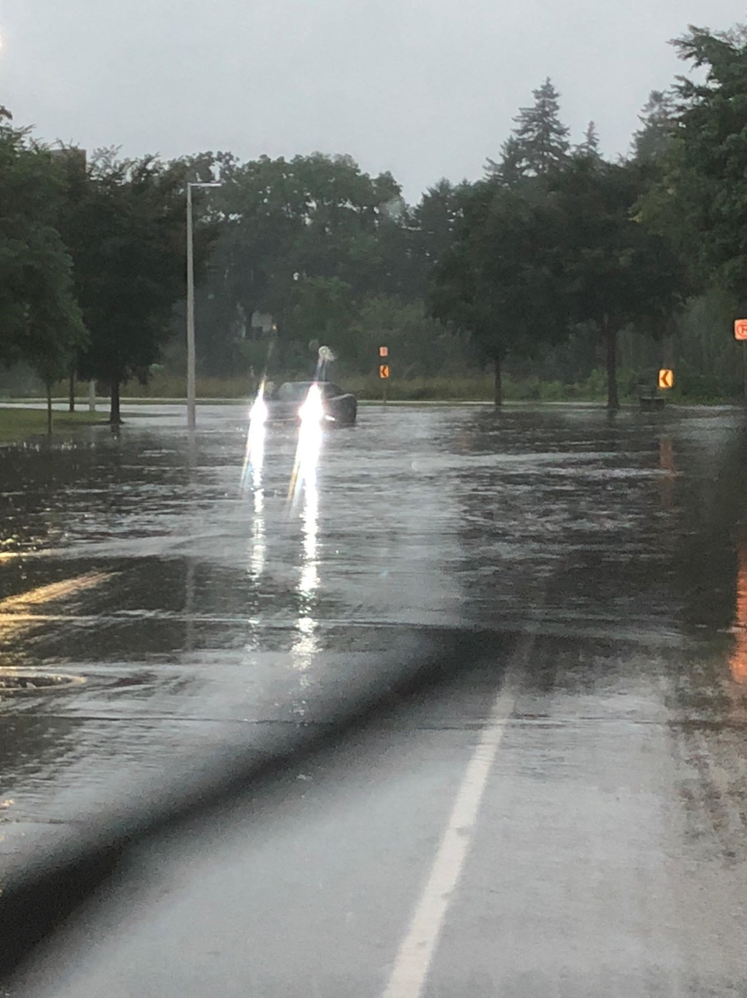
Flooding in Rochester, MN (Photo by Sarah Gannon/KTTC) |
Flooding near Silver Lake in Rochester, MN (Photo by Sarah Gannon/KTTC) |
Radar:
 |
 |
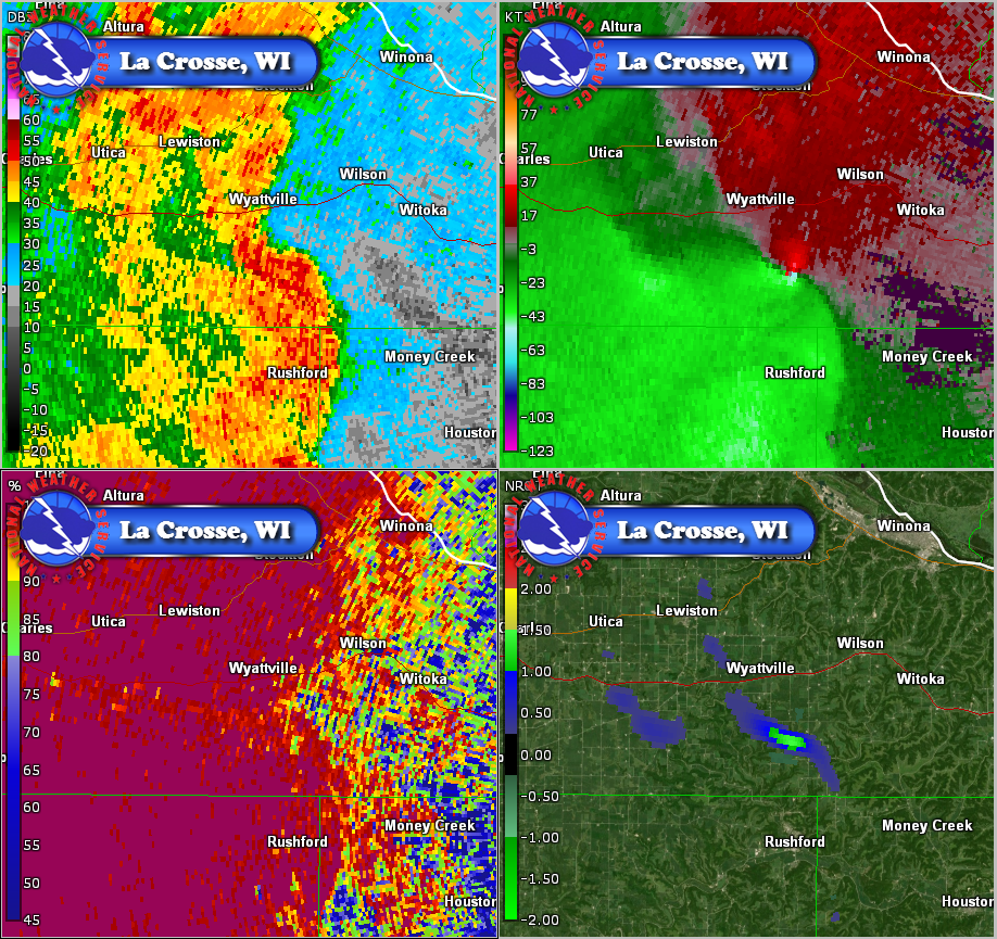 |
|
| Rainfall estimates from Sept.3-4, 2018 | Rainfall estimates from Sept.4-5, 2018 | Radar views of Winona Co. tornado |
Rain Reports from Sept.3-4, and Sept.4-5, 2018
Public Information Statement
National Weather Service La Crosse WI
1034 AM CDT Tue Sep 4 2018

...24-HOUR RAINFALL REPORTS ENDING TUE SEPT 4 AM...

Location                     Amount    Time/Date       Lat/Lon

...Iowa...

...Allamakee County...
3 S Dorchester               2.92 in   1000 AM 09/04   43.42N/91.51W
3 SE Waterville              2.43 in   1007 AM 09/04   43.17N/91.24W
1 E Rossville                1.58 in   0815 AM 09/04   43.19N/91.35W
Waukon 4SW                   0.91 in   0940 AM 09/04   43.24N/91.55W
4 WNW Lansing                0.89 in   0700 AM 09/04   43.40N/91.29W

...Chickasaw County...
New Hampton                  3.76 in   1003 AM 09/04   43.06N/92.32W
Ionia 2W                     0.56 in   0945 AM 09/04   43.03N/92.50W

...Clayton County...
Monona WWTP                  3.51 in   0700 AM 09/04   43.04N/91.40W
Elkader 5NW                  2.86 in   1000 AM 09/04   42.91N/91.47W
Volga 1NE                    2.46 in   0617 AM 09/04   42.81N/91.52W
Elkader 6SSW                 2.18 in   0700 AM 09/04   42.78N/91.45W
Strawberry Point             2.06 in   0700 AM 09/04   42.69N/91.53W
Marquette-Bloody Run Creek   1.02 in   1000 AM 09/04   43.04N/91.21W
Littleport                   0.93 in   0945 AM 09/04   42.75N/91.37W
Garber                       0.84 in   0915 AM 09/04   42.74N/91.26W
Guttenberg Dam 10            0.80 in   0600 AM 09/04   42.78N/91.10W

...Fayette County...
Oelwein Municipal Airport    2.18 in   0655 AM 09/04   42.68N/91.97W
Waucoma 1WNW                 1.60 in   0700 AM 09/04   43.06N/92.05W
1 ENE Alpha                  1.18 in   0700 AM 09/04   43.01N/92.03W
Eldorado                     0.64 in   0945 AM 09/04   43.05N/91.81W

...Floyd County...
Charles City Airport         0.96 in   0655 AM 09/04   43.07N/92.61W
Nashua 2SW                   0.93 in   0700 AM 09/04   42.94N/92.57W
Charles City                 0.56 in   0700 AM 09/04   43.06N/92.67W
Nora Springs 2.4 SSE         0.06 in   0700 AM 09/04   43.11N/92.99W

...Howard County...
Cresco 1NE                   1.28 in   0735 AM 09/04   43.39N/92.09W
Elma                         0.61 in   0700 AM 09/04   43.24N/92.44W
3 NE Riceville               0.32 in   1015 AM 09/04   43.40N/92.50W

...Mitchell County...
Osage                        0.66 in   0700 AM 09/04   43.28N/92.81W
St Ansgar                    0.64 in   0630 AM 09/04   43.38N/92.92W
3 W New Haven                0.33 in   0700 AM 09/04   43.28N/92.72W

...Winneshiek County...
7 ENE Decorah                3.11 in   0700 AM 09/04   43.34N/91.64W
1 ENE Jackson Junction       2.24 in   1003 AM 09/04   43.11N/92.04W
Decorah                      1.96 in   1003 AM 09/04   43.30N/91.79W
Decorah Municipal Airport    1.87 in   0655 AM 09/04   43.28N/91.74W
Spillville                   1.86 in   0930 AM 09/04   43.21N/91.95W
Fort Atkinson                1.75 in   0700 AM 09/04   43.14N/91.93W
Calmar NE                    1.55 in   0700 AM 09/04   43.19N/91.86W
Bluffton                     0.68 in   0945 AM 09/04   43.41N/91.90W

...Minnesota...

...Dodge County...
Hayfield                     1.24 in   0830 AM 09/04   43.89N/92.85W
2 E Claremont                0.60 in   0800 AM 09/04   44.04N/92.95W
Wasioja Alert Gage           0.51 in   0906 AM 09/04   44.07N/92.82W

...Fillmore County...
Spring Valley 3E             1.58 in   0700 AM 09/04   43.68N/92.33W
Pilot Mound-Root River       1.19 in   1000 AM 09/04   43.78N/92.03W
3 NE Preston                 0.89 in   0645 AM 09/04   43.71N/92.05W
Lanesboro-Root River         0.85 in   0930 AM 09/04   43.72N/91.98W
Mabel                        0.81 in   0630 AM 09/04   43.52N/91.76W
Lanesboro 2NE                0.76 in   0750 AM 09/04   43.73N/91.94W
Preston                      0.69 in   0745 AM 09/04   43.67N/92.07W
Spring Valley                0.69 in   0700 AM 09/04   43.69N/92.39W
Fillmore                     0.52 in   0930 AM 09/04   43.76N/92.27W
1 W Fillmore                 0.51 in   0700 AM 09/04   43.74N/92.31W

...Houston County...
4 NW Eitzen                  1.22 in   0800 AM 09/04   43.56N/91.51W
1 NNW La Crescent            1.08 in   0700 AM 09/04   43.83N/91.31W
Caledonia                    0.99 in   0700 AM 09/04   43.63N/91.50W
Mound Prairie                0.45 in   0945 AM 09/04   43.78N/91.45W
Houston                      0.40 in   0945 AM 09/04   43.77N/91.57W

...Mower County...
Lansing-Cedar River          0.83 in   0930 AM 09/04   43.75N/92.95W
Grand Meadow                 0.68 in   0700 AM 09/04   43.71N/92.56W
Austin 3 NW - Turtle Creek   0.58 in   0930 AM 09/04   43.65N/92.98W
2 WSW Mapleview              0.47 in   0600 AM 09/04   43.68N/93.03W
Austin Waste Water Treatment 0.44 in   0700 AM 09/04   43.65N/92.97W
Ostrander 5.1 WNW            0.39 in   0700 AM 09/04   43.65N/92.52W
Austin 2NE-Dobbins Creek     0.39 in   0930 AM 09/04   43.67N/92.95W
Austin 3S                    0.02 in   1000 AM 09/04   43.64N/92.97W

...Olmsted County...
4 WSW Rochester              1.74 in   1000 AM 09/04   43.98N/92.56W
Byron                        1.65 in   1017 AM 09/04   44.04N/92.64W
5 E Douglas                  1.60 in   1000 AM 09/04   44.10N/92.47W
4 ESE Douglas                1.51 in   1018 AM 09/04   44.09N/92.49W
Eyota 2NE                    1.36 in   0930 AM 09/04   44.01N/92.20W
2 NE Rochester               1.33 in   1018 AM 09/04   44.04N/92.44W
3 ESE Douglas                1.29 in   1020 AM 09/04   44.09N/92.51W
2 SE Douglas                 1.22 in   1020 AM 09/04   44.08N/92.55W
Byron                        1.21 in   1019 AM 09/04   44.03N/92.66W
Elgin 5SE                    1.20 in   0930 AM 09/04   44.01N/92.11W
Rochester                    1.17 in   1023 AM 09/04   44.01N/92.49W
Rochester-Cascade Creek      1.16 in   0930 AM 09/04   44.03N/92.47W
Oronoco                      1.10 in   0930 AM 09/04   44.16N/92.54W
Rochester-Beltline           1.10 in   0930 AM 09/04   44.01N/92.47W
2 NNE Rochester              1.08 in   1015 AM 09/04   44.05N/92.45W
1 NNE Rochester              1.05 in   0800 AM 09/04   44.04N/92.47W
Rochester-Beltline Bear Cree 1.04 in   0930 AM 09/04   44.01N/92.45W
2 ENE Rochester              1.02 in   0930 AM 09/04   44.03N/92.43W
Pine Island 1S               1.01 in   1000 AM 09/04   44.19N/92.65W
Oxbow Park Alert Gage        0.98 in   0929 AM 09/04   44.09N/92.64W
4 ESE Douglas                0.94 in   0700 AM 09/04   44.08N/92.48W
Elba 4.7 SW                  0.93 in   0900 AM 09/04   44.04N/92.09W
2 N Rock Dell                0.88 in   0830 AM 09/04   43.96N/92.63W
4 NNW Rochester              0.85 in   0711 AM 09/04   44.07N/92.49W
2 NNW Rochester              0.80 in   0700 AM 09/04   44.05N/92.49W
Oronoco 1W                   0.80 in   0930 AM 09/04   44.17N/92.55W
3 WNW Rochester              0.78 in   0700 AM 09/04   44.04N/92.53W
Rochester International Airp 0.73 in   0656 AM 09/04   43.91N/92.50W
3 SW Hammond                 0.72 in   1017 AM 09/04   44.18N/92.41W
Elgin 2SSW                   0.70 in   0700 AM 09/04   44.10N/92.27W
2 NNW Chester                0.69 in   0700 AM 09/04   44.05N/92.37W
1 W Chester                  0.59 in   0625 AM 09/04   44.00N/92.38W
Mayo Helipad                 0.51 in   0655 AM 09/04   44.02N/92.48W

...Wabasha County...
Plainview                    2.28 in   1003 AM 09/04   44.17N/92.17W
3 NW Buffalo                 1.68 in   1003 AM 09/04   44.26N/91.91W
Plainview                    1.47 in   1020 AM 09/04   44.17N/92.17W
Theilman 1SSW                1.20 in   0730 AM 09/04   44.28N/92.19W
Kellogg-Zumbro River         1.13 in   1000 AM 09/04   44.32N/92.00W
2 NNW Zumbro Falls           0.88 in   1024 AM 09/04   44.32N/92.44W
3 SW Zumbro Falls            0.70 in   0812 AM 09/04   44.24N/92.46W
Mazeppa 3ESE                 0.70 in   0930 AM 09/04   44.26N/92.49W
Lake City                    0.54 in   1015 AM 09/04   44.45N/92.27W

...Winona County...
Beaver-White Water River     1.34 in   0945 AM 09/04   44.15N/92.00W
Elba                         1.22 in   0945 AM 09/04   44.09N/92.03W
Great River Bluffs S.P.      1.21 in   0930 AM 09/04   43.94N/91.41W
Stockton                     1.20 in   0700 AM 09/04   44.03N/91.77W
Whitewater State Park Group  1.06 in   0930 AM 09/04   44.06N/92.05W
Lewiston                     1.05 in   0700 AM 09/04   43.99N/91.87W
2 NNW Pickwick               1.00 in   0700 AM 09/04   44.02N/91.61W
Dakota                       0.93 in   1015 AM 09/04   43.91N/91.36W
Altura 5w                    0.84 in   0700 AM 09/04   44.06N/92.04W
Winona Dam 5A                0.83 in   0600 AM 09/04   44.09N/91.67W
Winona Municipal Airport     0.75 in   0655 AM 09/04   44.08N/91.71W
La Crescent Dam 7            0.65 in   0600 AM 09/04   43.87N/91.31W
Minnesota City Dam 5         0.27 in   0700 AM 09/04   44.16N/91.81W

...Wisconsin...

...Adams County...
1 SSW Grand Marsh            4.16 in   0700 AM 09/04   43.86N/89.72W
Friendship                   3.52 in   0700 AM 09/04   43.98N/89.83W
2 S Brooks                   2.13 in   0654 AM 09/04   43.79N/89.64W
2 SE New Rome                1.51 in   0800 AM 09/04   44.21N/89.85W
Grand Marsh                  1.34 in   0700 AM 09/04   43.89N/89.73W

...Buffalo County...
Cochrane                     0.48 in   1003 AM 09/04   44.22N/91.83W
Alma Dam 4                   0.20 in   0600 AM 09/04   44.33N/91.92W

...Clark County...
OWEN 6SSE                    0.26 in   0700 AM 09/04   44.87N/90.51W
Neillsville 3ese             0.22 in   0600 AM 09/04   44.54N/90.53W
Neillsville 1W               0.15 in   0915 AM 09/04   44.56N/90.61W

...Crawford County...
Gays Mills                   5.25 in   0600 AM 09/04   43.32N/90.85W
Steuben                      3.80 in   0945 AM 09/04   43.18N/90.86W
1 WNW Mount Zion             3.32 in   0700 AM 09/04   43.26N/90.76W
Prairie Du Chien             3.00 in   0700 AM 09/04   43.05N/91.13W
Prairie Du Chien  Airport    1.58 in   0655 AM 09/04   43.02N/91.12W
Steuben 4SE                  1.56 in   0700 AM 09/04   43.13N/90.84W
De Soto 1SE                  1.41 in   0700 AM 09/04   43.42N/91.19W

...Grant County...
Fennimore                    1.72 in   1003 AM 09/04   42.98N/90.66W
Lancaster 4wsw               1.29 in   0800 AM 09/04   42.83N/90.79W
1 ENE Boscobel               0.82 in   1003 AM 09/04   43.15N/90.68W
Muscoda                      0.82 in   0700 AM 09/04   43.18N/90.44W
Cuba City                    0.75 in   0600 AM 09/04   42.61N/90.43W
Platteville                  0.41 in   0700 AM 09/04   42.74N/90.47W
Platteville Municipal Airpor 0.36 in   0655 AM 09/04   42.69N/90.44W

...Jackson County...
1 E Black River Falls        1.49 in   1015 AM 09/04   44.30N/90.83W
Black River Falls Area Airpo 1.13 in   0655 AM 09/04   44.25N/90.86W
Black River Falls Sewage     0.70 in   0800 AM 09/04   44.29N/90.85W
Mather 3NW                   0.63 in   0700 AM 09/04   44.17N/90.35W
Hatfield Dam                 0.50 in   0745 AM 09/04   44.41N/90.73W

...Juneau County...
Mauston                      4.44 in   1017 AM 09/04   43.80N/90.07W
New Lisbon 4ene              2.88 in   0600 AM 09/04   43.91N/90.07W
2 N Cloverdale               1.84 in   1010 AM 09/04   44.06N/90.17W
Necedah                      1.49 in   0948 AM 09/04   44.03N/90.08W
2 WNW Wisconsin Dells        1.39 in   1020 AM 09/04   43.65N/89.82W
Volk Field                   1.35 in   0656 AM 09/04   43.94N/90.25W
Mauston Airport              0.60 in   0655 AM 09/04   43.84N/90.14W

...La Crosse County...
3 W Saint Joseph             2.28 in   1024 AM 09/04   43.78N/91.10W
La Crosse Weather Office     1.10 in   0600 AM 09/04   43.82N/91.19W
Holmen 2S                    0.95 in   0700 AM 09/04   43.93N/91.25W
1 SW West Salem              0.80 in   0700 AM 09/04   43.88N/91.10W
La Crosse 4NNW               0.77 in   0730 AM 09/04   43.87N/91.27W
Onalaska                     0.77 in   0700 AM 09/04   43.88N/91.23W
Onalaska 2N                  0.77 in   0700 AM 09/04   43.91N/91.23W
La Crosse Regional Airport   0.71 in   0653 AM 09/04   43.88N/91.26W

...Monroe County...
3 WNW Kendall                1.68 in   0700 AM 09/04   43.81N/90.44W
Sparta/Fort McCoy Airport    1.09 in   0655 AM 09/04   43.96N/90.74W
Warrens 4WSW                 0.59 in   0700 AM 09/04   44.10N/90.59W
2 E Cataract                 0.54 in   1023 AM 09/04   44.09N/90.79W

...Richland County...
1 SSE Richland Center        3.44 in   1003 AM 09/04   43.32N/90.38W
Richland Center 4N           2.57 in   0700 AM 09/04   43.40N/90.39W

...Taylor County...
Medford                      0.37 in   0800 AM 09/04   45.13N/90.34W
Rib Lake                     0.29 in   0700 AM 09/04   45.32N/90.21W
Chelsea                      0.25 in   1015 AM 09/04   45.30N/90.30W
Medford Airport              0.17 in   0655 AM 09/04   45.10N/90.30W
3 NE Lublin                  0.11 in   1014 AM 09/04   45.11N/90.69W

...Trempealeau County...
1 NE Galesville              1.12 in   0600 AM 09/04   44.10N/91.34W
1 NW Trempealeau             1.08 in   0630 AM 09/04   44.03N/91.46W
Ettrick 4WNW                 0.70 in   0706 AM 09/04   44.19N/91.34W
Trempealeau Dam 6            0.53 in   0600 AM 09/04   44.00N/91.44W
Osseo                        0.14 in   0700 AM 09/04   44.58N/91.22W

...Vernon County...
Readstown                    5.93 in   1000 AM 09/04   43.45N/90.76W
Hillsboro WSW                4.83 in   0700 AM 09/04   43.65N/90.35W
Hillsboro 2SW                4.40 in   0700 AM 09/04   43.63N/90.38W
Genoa Dam 8                  3.12 in   0600 AM 09/04   43.57N/91.23W
Westby 3ENE                  2.15 in   0700 AM 09/04   43.67N/90.81W
3 WNW Viola                  2.04 in   0800 AM 09/04   43.53N/90.74W
Stoddard                     1.98 in   0700 AM 09/04   43.66N/91.22W
5 E Viroqua                  1.61 in   1017 AM 09/04   43.58N/90.77W
Viroqua 0.8 ESE              1.41 in   0700 AM 09/04   43.55N/90.87W
Stoddard 5NNE                1.37 in   0700 AM 09/04   43.72N/91.17W
Viroqua                      1.31 in   0700 AM 09/04   43.56N/90.88W
Viroqua Municipal Airport    1.20 in   0655 AM 09/04   43.58N/90.90W

Observations are collected from a variety of sources with varying
equipment and exposures. We thank all volunteer weather observers
for their dedication. Not all data listed are considered official.
PUBLIC INFORMATION STATEMENT NATIONAL WEATHER SERVICE LA CROSSE WI 1205 PM CDT WED SEP 5 2018 ...24 HOUR RAINFALL REPORTS ENDING SEPT 5 AM... LOCATION AMOUNT TIME/DATE LAT/LON ...IOWA... ...ALLAMAKEE COUNTY... 5 S WAUKON 2.80 IN 0905 AM 09/05 43.20N/91.48W 1 E ROSSVILLE 2.76 IN 0700 AM 09/05 43.19N/91.35W 6 NE POSTVILLE 2.53 IN 0729 AM 09/05 43.14N/91.49W 4 W ELON 2.30 IN 0919 AM 09/05 43.27N/91.40W 3 SE WATERVILLE 1.85 IN 0807 AM 09/05 43.17N/91.24W WAUKON 4SW 1.84 IN 0645 AM 09/05 43.24N/91.55W 4 WNW LANSING 1.71 IN 0700 AM 09/05 43.40N/91.29W 3 S DORCHESTER 0.95 IN 0800 AM 09/05 43.42N/91.51W ...CHICKASAW COUNTY... NEW HAMPTON 5.32 IN 0820 AM 09/05 43.06N/92.32W IONIA 2W 2.97 IN 0745 AM 09/05 43.03N/92.50W ...CLAYTON COUNTY... MCGREGOR 3.60 IN 0819 AM 09/05 43.02N/91.19W MONONA WWTP 1.96 IN 0700 AM 09/05 43.04N/91.40W ELKADER 5NW 1.83 IN 0800 AM 09/05 42.91N/91.47W MARQUETTE 1.76 IN 0800 AM 09/05 43.05N/91.18W VOLGA 1NE 1.53 IN 0629 AM 09/05 42.81N/91.52W ELKADER 5NW 1.50 IN 0400 AM 09/05 42.91N/91.47W LITTLEPORT 1.08 IN 0745 AM 09/05 42.75N/91.37W STRAWBERRY POINT 1.04 IN 0700 AM 09/05 42.69N/91.53W ELKADER 6SSW 0.99 IN 0700 AM 09/05 42.78N/91.45W LITTLEPORT 0.93 IN 0345 AM 09/05 42.75N/91.37W GARBER 0.63 IN 0815 AM 09/05 42.74N/91.26W GUTTENBERG 0.55 IN 0600 AM 09/05 42.79N/91.11W GUTTENBERG DAM 10 0.44 IN 0600 AM 09/05 42.78N/91.10W MARQUETTE-BLOODY RUN CREEK 0.40 IN 1100 AM 09/05 43.04N/91.21W ...FAYETTE COUNTY... 1 ENE ALPHA 2.56 IN 0708 AM 09/05 43.01N/92.03W ELDORADO 1.85 IN 0745 AM 09/05 43.05N/91.81W ...FLOYD COUNTY... NASHUA 2SW 2.80 IN 0500 AM 09/05 42.94N/92.57W CHARLES CITY 2.70 IN 0700 AM 09/05 43.06N/92.67W NASHUA 2SW 2.67 IN 0800 AM 09/05 42.93N/92.56W CHARLES CITY AIRPORT 2.29 IN 0655 AM 09/05 43.07N/92.61W NORA SPRINGS 2.4 SSE 1.98 IN 0700 AM 09/05 43.11N/92.99W ...HOWARD COUNTY... 3 NE RICEVILLE 3.20 IN 0815 AM 09/05 43.40N/92.50W CRESCO 1NE 2.91 IN 0735 AM 09/05 43.39N/92.09W ...MITCHELL COUNTY... 3 W NEW HAVEN 2.11 IN 0700 AM 09/05 43.28N/92.72W OSAGE 2.04 IN 0700 AM 09/05 43.28N/92.81W ST ANSGAR 1.60 IN 0630 AM 09/05 43.38N/92.92W SAINT ANSGAR 0.83 IN 0824 AM 09/05 43.38N/92.92W ...WINNESHIEK COUNTY... 1 ENE JACKSON JUNCTION 3.56 IN 0820 AM 09/05 43.11N/92.04W BLUFFTON 1.68 IN 0745 AM 09/05 43.41N/91.90W DECORAH 1.24 IN 0820 AM 09/05 43.30N/91.79W CALMAR NE 1.22 IN 0700 AM 09/05 43.19N/91.86W 5 ESE DECORAH 1.18 IN 0700 AM 09/05 43.26N/91.70W DECORAH 1.16 IN 0430 AM 09/05 43.30N/91.79W SPILLVILLE 1.13 IN 0730 AM 09/05 43.21N/91.95W DECORAH MUNICIPAL AIRPORT 0.94 IN 0655 AM 09/05 43.28N/91.74W 7 ENE DECORAH 0.86 IN 0730 AM 09/05 43.34N/91.64W ...MINNESOTA... ...DODGE COUNTY... 1 ESE KASSON 5.10 IN 1027 AM 09/05 44.02N/92.74W MANTORVILLE 4.17 IN 0716 AM 09/05 44.07N/92.76W 2 S KASSON 4.10 IN 0755 PM 09/04 44.00N/92.75W CLAREMONT 4.00 IN 1016 AM 09/05 44.05N/93.00W 1 W MANTORVILLE 3.70 IN 0700 AM 09/05 44.07N/92.78W HAYFIELD 3.37 IN 0817 AM 09/05 43.89N/92.85W 2 E CLAREMONT 3.27 IN 0800 AM 09/05 44.04N/92.95W WASIOJA ALERT GAGE 3.22 IN 0817 AM 09/05 44.07N/92.82W HAYFIELD 2.84 IN 0427 AM 09/05 43.89N/92.85W KASSON 2.82 IN 0752 PM 09/04 44.03N/92.75W WASIOJA 2.67 IN 0428 AM 09/05 44.07N/92.82W 2 NE KASSON 2.65 IN 0600 AM 09/05 44.05N/92.72W ...FILLMORE COUNTY... BRATSBERG 4.50 IN 1044 AM 09/05 43.74N/91.77W 5 WSW CUMMINGSVILLE 3.40 IN 0756 AM 09/05 43.83N/92.35W 3 S CARIMONA 3.10 IN 0920 AM 09/05 43.62N/92.15W CANTON 3.00 IN 0907 AM 09/05 43.53N/91.93W LANESBORO 2NE 2.75 IN 0645 AM 09/05 43.73N/91.94W HARMONY 2.63 IN 0730 AM 09/05 43.55N/92.01W LANESBORO 2.60 IN 0730 AM 09/05 43.72N/91.98W 3 NE PRESTON 2.45 IN 0700 AM 09/05 43.71N/92.05W 2 W FILLMORE 2.25 IN 0700 AM 09/05 43.74N/92.31W FILLMORE 2.13 IN 0730 AM 09/05 43.76N/92.27W 1 SSE PILOT MOUND 2.02 IN 0700 AM 09/05 43.79N/92.03W SPRING VALLEY 3E 2.00 IN 0700 AM 09/05 43.68N/92.33W FOUNTAIN 2.00 IN 1013 AM 09/05 43.74N/92.13W PILOT MOUND-ROOT RIVER 1.85 IN 0800 AM 09/05 43.78N/92.03W SPRING VALLEY 1.70 IN 0700 AM 09/05 43.69N/92.39W PRESTON AIRPORT 1.70 IN 0655 AM 09/05 43.68N/92.18W FILLMORE 1.65 IN 0430 AM 09/05 43.76N/92.27W 2 WSW FILLMORE 1.50 IN 1004 PM 09/04 43.74N/92.31W MABEL 1.38 IN 0635 AM 09/05 43.52N/91.76W ...HOUSTON COUNTY... HOUSTON 3.50 IN 1055 AM 09/05 43.76N/91.57W 1 NNW LA CRESCENT 1.77 IN 0700 AM 09/05 43.83N/91.31W LA CRESCENT 1.70 IN 0914 AM 09/05 43.83N/91.31W MOUND PRAIRIE 1.69 IN 0745 AM 09/05 43.78N/91.45W 1 SE MOUND PRAIRIE 1.52 IN 0845 AM 09/05 43.76N/91.43W CALEDONIA 1.39 IN 0700 AM 09/05 43.63N/91.50W 4 NW EITZEN 1.20 IN 0800 AM 09/05 43.56N/91.51W ...MOWER COUNTY... LANSING-CEDAR RIVER 3.08 IN 0730 AM 09/05 43.75N/92.95W AUSTIN 3 NW - TURTLE CREEK 2.84 IN 0730 AM 09/05 43.65N/92.98W AUSTIN 2 NE - DOBBINS CREEK 2.74 IN 0730 AM 09/05 43.67N/92.95W 2 WSW MAPLEVIEW 2.60 IN 0600 AM 09/05 43.68N/93.03W LANSING - CEDAR RIVER 2.41 IN 0330 AM 09/05 43.75N/92.95W 4 WSW AUSTIN 2.34 IN 0703 AM 09/05 43.64N/93.05W GRAND MEADOW 2.10 IN 0600 AM 09/05 43.71N/92.56W AUSTIN 3 NW - TURTLE CREEK 2.05 IN 0330 AM 09/05 43.65N/92.98W AUSTIN 3S 1.78 IN 0800 AM 09/05 43.64N/92.97W OSTRANDER 5.1 WNW 1.67 IN 0700 AM 09/05 43.65N/92.52W AUSTIN 3S 1.66 IN 0400 AM 09/05 43.64N/92.97W ...OLMSTED COUNTY... 2 NE ROCHESTER 6.64 IN 1127 AM 09/05 44.04N/92.44W 1 SE ROCHESTER 6.25 IN 0944 AM 09/05 44.01N/92.46W 1 NW ROCHESTER 6.02 IN 0946 AM 09/05 44.03N/92.49W 3 ESE DOUGLAS 5.90 IN 0654 AM 09/05 44.08N/92.51W 2 NE ROCHESTER 5.66 IN 0600 AM 09/05 44.04N/92.44W 3 SE DOUGLAS 5.60 IN 0629 AM 09/05 44.08N/92.53W 4 NE ROCHESTER 5.60 IN 0737 AM 09/05 44.06N/92.43W 2 ENE ROCHESTER 5.48 IN 0730 AM 09/05 44.03N/92.43W 3 WNW CHESTER 5.42 IN 0830 AM 09/05 44.04N/92.40W ROCHESTER-BELTLINE 5.36 IN 1130 PM 09/04 44.01N/92.47W 2 NNW ROCHESTER 5.30 IN 0700 AM 09/05 44.05N/92.49W 2 N ROCK DELL 5.15 IN 0745 AM 09/05 43.96N/92.63W 2 ENE ROCHESTER 5.06 IN 1030 AM 09/05 44.03N/92.43W 2 SW ROCHESTER 5.04 IN 0644 AM 09/05 43.99N/92.50W ROCHESTER 5.04 IN 0656 AM 09/05 44.01N/92.47W 2 ENE ROCHESTER 5.01 IN 0330 AM 09/05 44.03N/92.43W ROCHESTER-CASCADE CREEK 4.96 IN 0730 AM 09/05 44.03N/92.47W 4 NNW ROCHESTER 4.90 IN 0657 AM 09/05 44.07N/92.49W ROCHESTER-BELTLINE 4.89 IN 0330 AM 09/05 44.01N/92.47W 4 ESE DOUGLAS 4.78 IN 0821 AM 09/05 44.09N/92.49W 3 SE DOUGLAS 4.75 IN 0833 PM 09/04 44.08N/92.53W ROCHESTER-CASCADE CREEK 4.60 IN 0330 AM 09/05 44.03N/92.47W MAYO HELIPAD 4.60 IN 0655 AM 09/05 44.02N/92.48W 3 E ROCHESTER 4.55 IN 1059 AM 09/05 44.02N/92.42W 5 E DOUGLAS 4.45 IN 1000 AM 09/05 44.10N/92.47W 4 ESE DOUGLAS 4.30 IN 0421 AM 09/05 44.09N/92.49W 2 NNW CHESTER 4.25 IN 0730 AM 09/05 44.05N/92.37W 2 NNW CHESTER 4.25 IN 0730 AM 09/05 44.05N/92.37W ROCHESTER 4.14 IN 0433 AM 09/05 44.01N/92.49W 2 NNE ROCHESTER 4.11 IN 0435 AM 09/05 44.05N/92.45W ELGIN 2SSW 4.08 IN 0700 AM 09/05 44.10N/92.27W 3 NE ROCHESTER 4.05 IN 0810 PM 09/04 44.04N/92.44W PINE ISLAND 1S 4.03 IN 0800 AM 09/05 44.19N/92.65W 3 NW ROCHESTER 4.00 IN 0759 PM 09/04 44.05N/92.51W 2 NE ROCHESTER 3.97 IN 0435 AM 09/05 44.04N/92.44W OXBOW PARK ALERT GAGE 3.93 IN 0809 AM 09/05 44.09N/92.64W 2 W HIGH FOREST 3.87 IN 0600 AM 09/05 43.85N/92.59W OXBOW PARK ALERT GAGE 3.81 IN 0436 AM 09/05 44.09N/92.64W BYRON 3.77 IN 0821 AM 09/05 44.03N/92.66W 4 ESE DOUGLAS 3.75 IN 0700 PM 09/04 44.08N/92.51W 2 SE DOUGLAS 3.74 IN 0823 AM 09/05 44.08N/92.55W ROCHESTER AP 2NE 3.65 IN 0700 AM 09/05 43.93N/92.48W ORONOCO 3.53 IN 0730 AM 09/05 44.16N/92.54W 1 W CHESTER 3.49 IN 0612 AM 09/05 44.00N/92.38W 1 W CHESTER 3.49 IN 0612 AM 09/05 44.00N/92.38W BYRON 3.40 IN 0434 AM 09/05 44.04N/92.64W 3 ESE DOUGLAS 3.38 IN 0820 AM 09/05 44.09N/92.51W PINE ISLAND 1S 3.29 IN 0400 AM 09/05 44.19N/92.65W 2 SE DOUGLAS 3.16 IN 0422 AM 09/05 44.08N/92.55W 4 WSW ROCHESTER 3.07 IN 0700 PM 09/04 43.98N/92.56W ORONOCO 3.05 IN 0430 AM 09/05 44.16N/92.54W 3 ESE DOUGLAS 3.04 IN 0430 AM 09/05 44.09N/92.51W 2 N DOVER 3.00 IN 1019 AM 09/05 44.00N/92.14W ROCHESTER INTERNATIONAL AIRP 2.99 IN 0654 AM 09/05 43.91N/92.50W ORONOCO 1W 2.97 IN 0730 AM 09/05 44.17N/92.55W 3 SW HAMMOND 2.95 IN 0820 AM 09/05 44.18N/92.41W 2 NNW ROCHESTER 2.93 IN 0751 PM 09/04 44.04N/92.49W ORONOCO 1W 2.47 IN 0430 AM 09/05 44.17N/92.55W 3 SW HAMMOND 2.38 IN 0434 AM 09/05 44.18N/92.41W STEWARTVILLE 2.30 IN 0953 AM 09/05 43.86N/92.49W ELGIN 5SE 2.20 IN 0730 AM 09/05 44.01N/92.11W 2 W ROCHESTER 1.90 IN 0636 PM 09/04 44.01N/92.52W EYOTA 2NE 1.88 IN 0730 AM 09/05 44.01N/92.20W ELGIN 5SE 1.79 IN 0330 AM 09/05 44.01N/92.11W ROCHESTER-BELTLINE BEAR CREE 1.76 IN 0730 AM 09/05 44.01N/92.45W EYOTA 2NE 1.46 IN 0330 AM 09/05 44.01N/92.20W ROCHESTER-BELTLINE BEAR CREE 1.32 IN 0330 AM 09/05 44.01N/92.45W ELBA 4.7 SW 1.07 IN 0730 AM 09/05 44.04N/92.09W 2 SSE ROCHESTER 0.70 IN 0905 AM 09/05 43.99N/92.47W ...WABASHA COUNTY... 2 S WABASHA 4.92 IN 1051 AM 09/05 44.35N/92.05W PLAINVIEW 4.84 IN 0819 AM 09/05 44.17N/92.17W KELLOGG-ZUMBRO RIVER 4.60 IN 0800 AM 09/05 44.32N/92.00W LAKE CITY 4.57 IN 0700 AM 09/05 44.44N/92.28W PLAINVIEW 4.48 IN 0429 AM 09/05 44.17N/92.17W 3 NW WABASHA 3.95 IN 0419 AM 09/05 44.41N/92.09W THEILMAN 1SSW 3.94 IN 0730 AM 09/05 44.28N/92.19W PLAINVIEW 3.93 IN 0820 AM 09/05 44.17N/92.17W KELLOGG-ZUMBRO RIVER 3.67 IN 0400 AM 09/05 44.32N/92.00W 2 SE WABASHA 3.64 IN 0821 PM 09/04 44.35N/92.02W 3 NW WABASHA 3.60 IN 1133 AM 09/05 44.40N/92.08W LAKE CITY 3.54 IN 0715 AM 09/05 44.45N/92.27W PLAINVIEW 3.53 IN 0432 AM 09/05 44.17N/92.17W MAZEPPA 3ESE 3.51 IN 0730 AM 09/05 44.26N/92.49W 1 NNE WABASHA 3.50 IN 0715 AM 09/05 44.38N/92.03W LAKE CITY 3.31 IN 0815 AM 09/05 44.45N/92.27W 3 SW ZUMBRO FALLS 3.17 IN 0700 AM 09/05 44.24N/92.46W 2 NNW ZUMBRO FALLS 3.15 IN 0824 AM 09/05 44.32N/92.44W MAZEPPA 3ESE 2.81 IN 0430 AM 09/05 44.26N/92.49W WABASHA 2.27 IN 0730 PM 09/04 44.38N/92.03W LAKE CITY 2.23 IN 0430 AM 09/05 44.45N/92.27W 2 NNW ZUMBRO FALLS 1.93 IN 0434 AM 09/05 44.32N/92.44W ...WINONA COUNTY... STOCKTON 4.00 IN 1015 AM 09/05 44.03N/91.77W MINNESOTA CITY DAM 5 3.90 IN 0600 AM 09/05 44.16N/91.81W 1 WSW WINONA 3.48 IN 0710 AM 09/05 44.03N/91.68W WINONA DAM 5A 3.46 IN 0600 AM 09/05 44.09N/91.67W WINONA 4SW 3.08 IN 0906 AM 09/05 43.98N/91.71W WHITEWATER STATE PARK GROUP 3.02 IN 0730 AM 09/05 44.06N/92.05W WINONA MUNICIPAL AIRPORT 2.86 IN 0655 AM 09/05 44.08N/91.71W WHITEWATER STATE PARK GROUP 2.63 IN 0330 AM 09/05 44.06N/92.05W STOCKTON 2.61 IN 0630 AM 09/05 44.03N/91.77W LEWISTON 2.42 IN 0700 AM 09/05 43.99N/91.87W BEAVER-WHITE WATER RIVER 2.40 IN 0745 AM 09/05 44.15N/92.00W 2 NNW PICKWICK 2.35 IN 0700 AM 09/05 44.02N/91.61W ELBA 2.33 IN 0745 AM 09/05 44.09N/92.03W DAKOTA 2.29 IN 0815 AM 09/05 43.91N/91.36W 1 ESE MINNESOTA CITY 2.14 IN 0700 AM 09/05 44.08N/91.73W ELBA 2.01 IN 0345 AM 09/05 44.09N/92.03W SAINT CHARLES 2.00 IN 1035 AM 09/05 43.97N/92.06W GREAT RIVER BLUFFS S.P. 1.90 IN 0730 AM 09/05 43.94N/91.41W LA CRESCENT DAM 7 1.88 IN 0600 AM 09/05 43.87N/91.31W GREAT RIVER BLUFFS S.P. 1.77 IN 0430 AM 09/05 43.94N/91.41W BEAVER-WHITE WATER RIVER 1.58 IN 0345 AM 09/05 44.15N/92.00W ...WISCONSIN... ...ADAMS COUNTY... 1 SSW GRAND MARSH 1.40 IN 0700 AM 09/05 43.86N/89.72W CASTLE ROCK 1.35 IN 0830 AM 09/05 43.87N/89.95W FRIENDSHIP 1.05 IN 0700 AM 09/05 43.98N/89.83W 2 S BROOKS 0.97 IN 0633 AM 09/05 43.79N/89.64W PETENWELL LAKE 0.87 IN 0935 AM 09/05 44.08N/90.00W 2 SE NEW ROME 0.83 IN 0700 AM 09/05 44.21N/89.85W ...BUFFALO COUNTY... 5 SSW GILMANTON 5.90 IN 1031 AM 09/05 44.41N/91.72W WAUMANDEE 5.75 IN 0810 AM 09/05 44.31N/91.71W 5 NE MONTANA 4.82 IN 0700 AM 09/05 44.40N/91.60W ALMA DAM 4 4.48 IN 0600 AM 09/05 44.33N/91.92W BUFFALO 4.47 IN 1107 PM 09/04 44.23N/91.86W ...CLARK COUNTY... OWEN 6SSE 6.15 IN 0700 AM 09/05 44.87N/90.51W HUMBIRD 4.60 IN 0942 AM 09/05 44.53N/90.89W 3 SW SPENCER 4.13 IN 0709 AM 09/05 44.71N/90.34W 1 NNE DORCHESTER 3.56 IN 1100 PM 09/04 45.02N/90.33W ...CRAWFORD COUNTY... 1 N MOUNT ZION 2.75 IN 1022 AM 09/05 43.27N/90.73W 1 WNW MOUNT ZION 2.66 IN 0700 AM 09/05 43.26N/90.76W 5 N PRAIRIE DU CHIEN 2.50 IN 1050 AM 09/05 43.12N/91.14W STEUBEN 4SE 2.41 IN 0700 AM 09/05 43.13N/90.84W STEUBEN 2.39 IN 0745 AM 09/05 43.18N/90.86W 1 NNE PRAIRIE DU CHIEN 2.32 IN 1117 AM 09/05 43.05N/91.13W DE SOTO 1SE 2.25 IN 0600 AM 09/05 43.42N/91.19W PRAIRIE DU CHIEN 2.22 IN 0945 AM 09/05 43.05N/91.14W GAYS MILLS 2.00 IN 0630 AM 09/05 43.32N/90.85W 5 NNE PRAIRIE DU CHIEN 2.00 IN 0644 AM 09/05 43.11N/91.11W PRAIRIE DU CHIEN 1.63 IN 0700 AM 09/05 43.05N/91.13W PRAIRIE DU CHIEN AIRPORT 1.54 IN 0655 AM 09/05 43.02N/91.12W DE SOTO 1.50 IN 0431 AM 09/05 43.42N/91.19W ...GRANT COUNTY... BOSCOBEL AIRPORT 2.09 IN 0653 AM 09/05 43.16N/90.67W 1 ENE BOSCOBEL 2.02 IN 0803 AM 09/05 43.15N/90.68W MUSCODA 1.81 IN 1015 AM 09/05 43.18N/90.44W 3 NW MOUNT HOPE 1.50 IN 1008 AM 09/05 43.00N/90.90W 1 ENE BOSCOBEL 1.26 IN 0403 AM 09/05 43.15N/90.68W FENNIMORE 1.24 IN 0820 AM 09/05 42.98N/90.66W CUBA CITY 0.72 IN 0800 AM 09/05 42.60N/90.43W SINSINAWA 0.67 IN 0700 AM 09/05 42.52N/90.54W LANCASTER 4WSW 0.65 IN 0825 AM 09/05 42.83N/90.79W PLATTEVILLE AIRPORT 0.38 IN 0655 AM 09/05 42.69N/90.44W PLATTEVILLE 0.29 IN 0700 AM 09/05 42.74N/90.47W ...JACKSON COUNTY... HATFIELD 4.00 IN 1041 AM 09/05 44.42N/90.73W HATFIELD DAM 3.10 IN 0830 AM 09/05 44.41N/90.73W 1 NNW TAYLOR 3.00 IN 1001 AM 09/05 44.33N/91.12W 5 ESE IRVING 2.78 IN 1100 AM 09/05 44.17N/90.80W BLACK RIVER FALLS SEWAGE 2.30 IN 0830 AM 09/05 44.29N/90.85W 1 E BLACK RIVER FALLS 1.97 IN 0815 AM 09/05 44.30N/90.83W BLACK RIVER FALLS AREA AIRPO 1.96 IN 0655 AM 09/05 44.25N/90.86W MATHER 3NW 1.75 IN 0700 AM 09/05 44.17N/90.35W ...JUNEAU COUNTY... 2 N CLOVERDALE 1.51 IN 0810 AM 09/05 44.06N/90.17W 2 WNW WISCONSIN DELLS 1.26 IN 0820 AM 09/05 43.65N/89.82W VOLK FIELD 1.25 IN 0656 AM 09/05 43.94N/90.25W 2 N CLOVERDALE 1.16 IN 0410 AM 09/05 44.06N/90.17W 2 W DELLWOOD 1.04 IN 0700 AM 09/05 43.99N/89.99W NEW LISBON 4ENE 1.01 IN 0700 AM 09/05 43.91N/90.07W NECEDAH 0.85 IN 0748 AM 09/05 44.03N/90.08W 2 WNW WISCONSIN DELLS 0.50 IN 0430 AM 09/05 43.65N/89.82W MAUSTON 0.49 IN 0822 AM 09/05 43.80N/90.07W MAUSTON AIRPORT 0.35 IN 0655 AM 09/05 43.84N/90.14W ...LA CROSSE COUNTY... ONALASKA 2.90 IN 0800 AM 09/05 43.89N/91.22W MELROSE 8.2 SSW 2.86 IN 0800 AM 09/05 44.02N/91.06W 2 SSE HOLMEN 2.10 IN 0500 AM 09/05 43.94N/91.24W ONALASKA 2N 1.89 IN 0700 AM 09/05 43.91N/91.23W HOLMEN 2S 1.88 IN 0700 AM 09/05 43.93N/91.25W ST JOSEPH 3 W 1.77 IN 0700 AM 09/05 43.78N/91.10W LA CROSSE REGIONAL AIRPORT 1.75 IN 0653 AM 09/05 43.88N/91.26W WEST SALEM 2W 1.70 IN 0700 AM 09/05 43.90N/91.12W 1 SW BARRE MILLS 1.69 IN 0700 AM 09/05 43.82N/91.13W LA CROSSE 4NNW 1.69 IN 0730 AM 09/05 43.87N/91.27W ONALASKA 1.65 IN 0700 AM 09/05 43.88N/91.23W LA CROSSE WEATHER OFFICE 1.56 IN 0600 AM 09/05 43.82N/91.19W 1 SE LA CROSSE 1.40 IN 0952 AM 09/05 43.81N/91.22W ...MONROE COUNTY... CATARACT 2.15 IN 0800 AM 09/05 44.08N/90.85W 4 S TUNNEL CITY 2.13 IN 1039 AM 09/05 43.95N/90.56W WILTON 2.10 IN 1011 AM 09/05 43.82N/90.53W WARRENS 4WSW 1.91 IN 0700 AM 09/05 44.10N/90.59W 3 WNW KENDALL 1.70 IN 0700 AM 09/05 43.81N/90.44W 2 E CATARACT 1.65 IN 0823 AM 09/05 44.09N/90.79W SPARTA 1.49 IN 0800 AM 09/05 43.94N/90.82W ...RICHLAND COUNTY... 3 SW LOYD 4.50 IN 1009 AM 09/05 43.39N/90.28W 1 SSE RICHLAND CENTER 3.48 IN 0429 AM 09/05 43.32N/90.38W RICHLAND CENTER 4N 2.20 IN 0700 AM 09/05 43.40N/90.39W ...TAYLOR COUNTY... 2 N DORCHESTER 5.75 IN 0823 AM 09/05 45.04N/90.33W GAD 4.33 IN 0700 AM 09/05 45.14N/90.20W MEDFORD 3.40 IN 0800 AM 09/05 45.13N/90.34W MEDFORD AIRPORT 3.36 IN 0655 AM 09/05 45.10N/90.30W 3 NE LUBLIN 2.80 IN 0814 AM 09/05 45.11N/90.69W RIB LAKE 2.65 IN 0700 AM 09/05 45.32N/90.21W 3 NE LUBLIN 2.26 IN 0414 AM 09/05 45.11N/90.69W 4 WNW HANNIBAL 2.12 IN 0800 AM 09/05 45.28N/90.86W CHELSEA 2.09 IN 0815 AM 09/05 45.30N/90.30W 2 N DORCHESTER 1.79 IN 1003 PM 09/04 45.04N/90.34W ...TREMPEALEAU COUNTY... 3 S ARCADIA 4.50 IN 0904 AM 09/05 44.21N/91.49W ETTRICK 4WNW 4.11 IN 0700 AM 09/05 44.19N/91.34W 2 N GALESVILLE 3.50 IN 0951 AM 09/05 44.12N/91.36W 3 N ARCADIA 3.10 IN 1026 AM 09/05 44.30N/91.49W 1 NE GALESVILLE 2.24 IN 0700 AM 09/05 44.10N/91.34W 1 NW TREMPEALEAU 1.61 IN 0600 AM 09/05 44.03N/91.46W TREMPEALEAU DAM 6 1.57 IN 0600 AM 09/05 44.00N/91.44W ...VERNON COUNTY... VIOLA 3.00 IN 0959 AM 09/05 43.51N/90.67W WESTBY 3ENE 2.44 IN 0700 AM 09/05 43.67N/90.81W 4 NNE CLAYTON 2.10 IN 0828 AM 09/05 43.43N/90.68W VIROQUA MUNICIPAL AIRPORT 2.03 IN 0655 AM 09/05 43.58N/90.90W HILLSBORO 2SW 1.98 IN 0700 AM 09/05 43.63N/90.38W VIROQUA 1.96 IN 0700 AM 09/05 43.56N/90.88W READSTOWN 1.88 IN 0800 AM 09/05 43.45N/90.76W VIROQUA 0.8 ESE 1.86 IN 0700 AM 09/05 43.55N/90.87W 3 WNW VIOLA 1.66 IN 0800 AM 09/05 43.53N/90.74W HILLSBORO WSW 1.62 IN 0700 AM 09/05 43.65N/90.35W 5 E VIROQUA 1.50 IN 0822 AM 09/05 43.58N/90.77W 2 NE STODDARD 1.50 IN 1048 AM 09/05 43.69N/91.19W STODDARD 1.42 IN 0700 AM 09/05 43.66N/91.22W STODDARD 5NNE 1.40 IN 0700 AM 09/05 43.72N/91.17W 5 E VIROQUA 1.33 IN 0432 AM 09/05 43.58N/90.77W LA FARGE 1.28 IN 0828 AM 09/05 43.58N/90.64W GENOA DAM 8 1.20 IN 0600 AM 09/05 43.57N/91.23W OBSERVATIONS ARE COLLECTED FROM A VARIETY OF SOURCES WITH VARYING EQUIPMENT AND EXPOSURES. WE THANK ALL VOLUNTEER WEATHER OBSERVERS FOR THEIR DEDICATION. NOT ALL DATA LISTED ARE CONSIDERED OFFICIAL.
 |
Media use of NWS Web News Stories is encouraged! Please acknowledge the NWS as the source of any news information accessed from this site. |
|


 Weather Story
 Weather Map
 Local Radar