Temperatures:
|
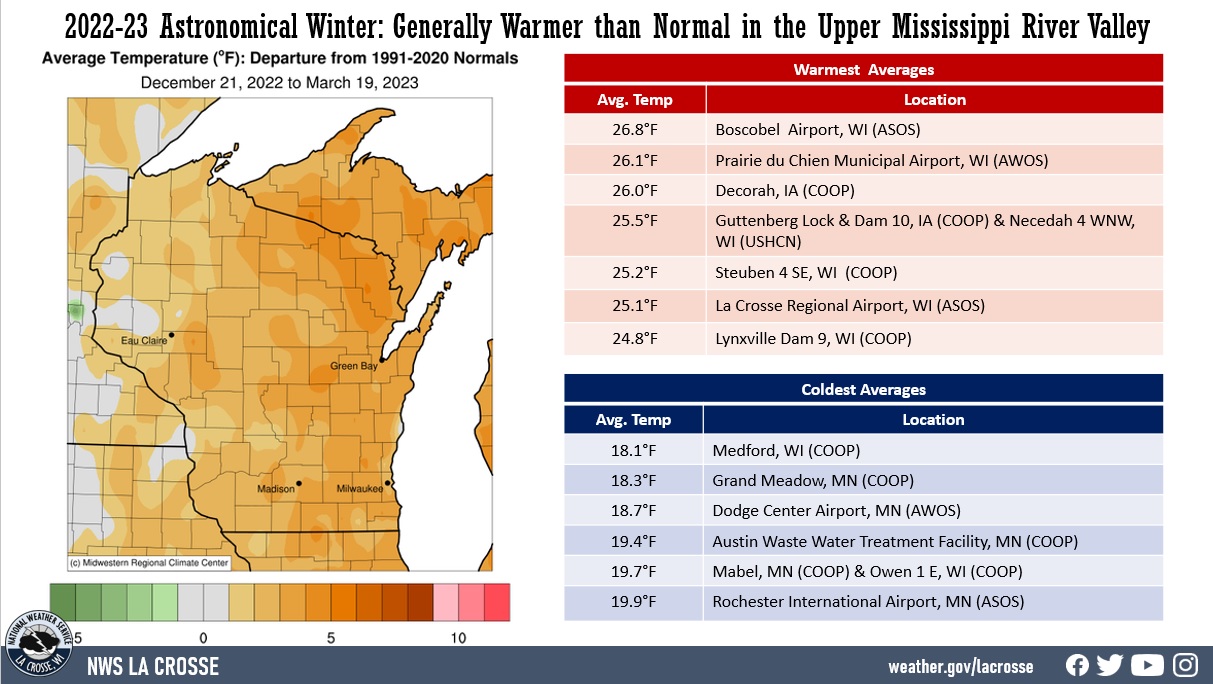
During astronomical winter 2022-23 (December 21-March 19), average temperatures ranged from 18.1°F at Medford, WI (COOP) to 26.8°F at Boscobel Airport, WI (ASOS). These temperatures ranged from near-normal to 4°F warmer than normal. The largest departures were in Wisconsin. The warmest temperature was 55°F at Boscobel Airport (ASOS), WI. The coldest temperature was -25°F at Black River Falls, WI (RAWS); at Preston, MN (COOP); and near Theilman, MN (COOP) on January 31; and southwest of Elkader, IA on February 1.
|
 |
Precipitation:
|
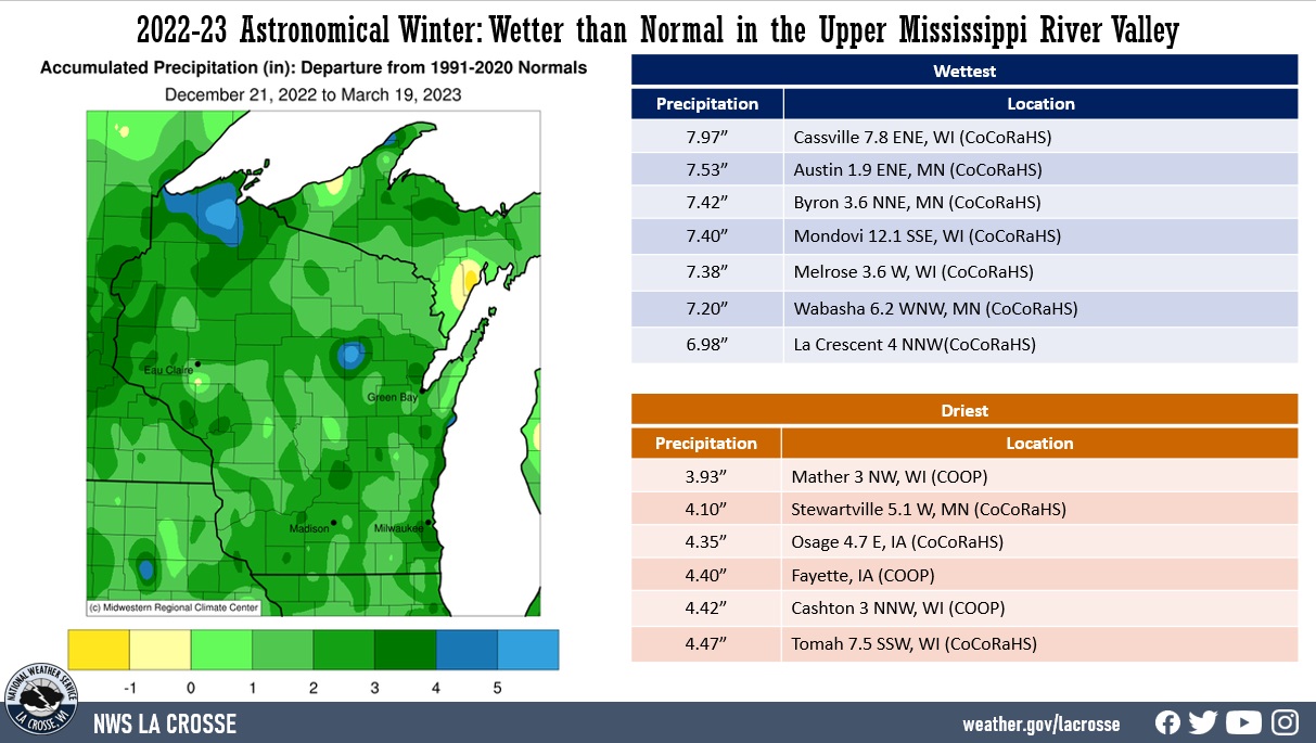
Precipitation ranged from 3.93" near Mather, WI (CoCoRaHS) to 7.97" near Cassville, WI (CoCoRaHS). These precipitation values ranged from near-normal to 4" wetter-than-normal. Rochester, MN had its 3rd wettest astronomical winter (6.30"), and La Crosse, WI had its 8th wettest (6.49”) astronomical winter. The greatest 1-day precipitation total was 1.54" near Nashua, WI (COOP) from 7 am on February 26 to 7 am on February 27.
|
 |
Snowfall:
|
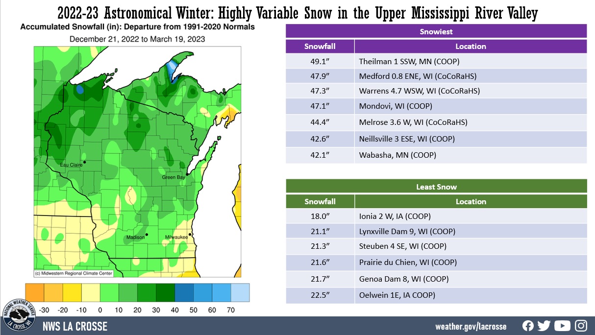
Snowfall ranged from 18" near Ionia, IA (COOP) to 49.1" near Theilman, MN (COOP). These snowfall values ranged from 10" below normal to 20" above normal. Rochester, MN had its 22nd snowiest astronomical winter. The greatest 1-day snowfall total was 1.68" near Mather, WI (COOP) from 7 am on December 14 to 7 am on December 15. The greatest 1-day snowfall was 13.2" at Theilman, MN (COOP). This snow fell from 7 AM on February 22 to 7 AM on February 23. This was the snowiest February day there. The previous record was 12.2" on February 24, 2019.
|
 |
Below are climate summaries for La Crosse, WI, and Rochester, MN.
La Crosse, WI
Astronomical Winter 2022-23 was Warmer and Much Wetter than Normal in La Crosse, WII
Temperatures - Warmest Since the Winter of 2019-20
- During astronomical winter, temperatures averaged 25.1°F at La Crosse Regional Airport.
- This was 4.2°F warmer than the long-term (1872-2023) average of 20.9°F.
- This was the warmest astronomical winter since 2019-2020 (27.7°F - 10th warmest ).
- 7 out of the last 9 astronomical winters have been warmer than the long-term average. This included the 4th (2016-17) and the 10th (2019-20) warmest astronomical winters.
|
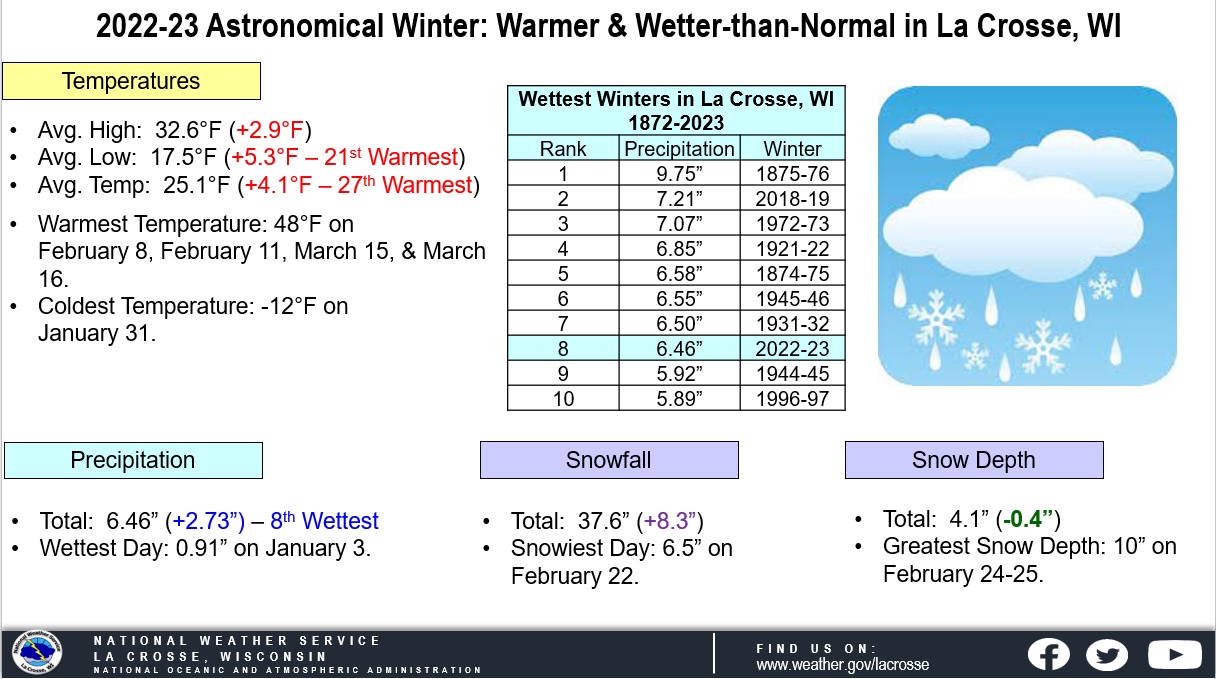 |
- The average high temperature was 32.6°F. This was 2.9°F warmer than the long-term average of 29.7°F.
- The average low temperature was 17.5°F. This was 5.3°F warmer than the long-term average of 12.1°F.
- The warmest high temperature was 48°F on February 8, February 11, March 15, and March 16.
- The coldest high temperature was 1°F on December 23.
- The warmest low temperature was 37°F on February 14.
- The coldest low temperature was -12°F on January 31.
​Precipitation - 8th Wettest
- During astronomical winter, a total of 6.46" of precipitation fell at La Crosse Regional Airport.
- This was 2.73" wetter than the long-term (1872-2023) average of 3.73".
- This was the 8th wettest astronomical winter and the wettest since 2018-2019 (7.21" - 2nd wettest). The wettest winter was back in 1875-1876 when 9.75" of precipitation fell.
Below are the ten wettest winters.
10 Wettest Astronomical
Winters for La Crosse, WI
1872-2023
Rank Precipitation Winters
---- ------------- -------
1 9.75 inches 1875-76
2 7.21 inches 2018-19
3 7.07 inches 1972-73
4 6.85 inches 1921-22
5 6.58 inches 1874-75
6 6.55 inches 1945-46
7 6.50 inches 1931-32
8 6.46 inches 2022-23
9 5.92 inches 1944-45
10 5.89 inches 1996-97
- The wettest day occurred on January 3 when 0.91" of precipitation fell.
- Measurable (0.01 inches or greater) precipitation fell on 36 days (40.4%) and trace amounts of precipitation fell on another 9 days (10.1%).
Snowfall - Above Average
- During astronomical winter, a total of 37.6" of snow was measured by the official NWS snow observer near La Crosse Regional Airport. This was 8.3" snowier than the long-term (1896-2023) average of 29.3".
- This was the most snow in an astronomical winter since 2018-2019 (53.3" - 3rd snowiest).
- The snowiest day occurred on February 22 when 6.5" of snow fell.
- Measurable (0.1" or greater) snow fell on 28 days (31.5%) and trace amounts of snow fell on another 10 days (11.2%).
Snow Depth - Slightly Below Average
- During astronomical winter, the average snow depth measured by the official NWS snow observer was 4.1". This was 0.3" below the long-term (1893-2023) average of 4.4". This was the same average snow depth as the 2021-22 astronomical winter.
- Measurable snow was on the ground on 67 days or 75.3% of the season.
- A trace of snow was on the ground on 12 days or 13.5% of the season.
- There was no snow on the ground for 10 days or 11.2% of the season.
- The greatest snow depth was 10" between February 24 and February 25.
Rochester, MN
Astronomical Winter 2022-23 was Warmer and Much Wetter than Normal in Rochester, MN
Temperatures - Warmer than Normal
- During astronomical winter, temperatures averaged 19.9°F at Rochester International Airport.
- This was 2.1°F warmer than the long-term (1886-2023) average of 17.8°F.
- This was the warmest astronomical winter since 2019-2020 (22.4°F tied for 18th warmest with 1943-44).
- The average high temperature was 27°F. This was 0.5°F warmer than the long-term average of 26.5°F.
- The average low temperature was 12.7°F. This was 3.6°F warmer than the long-term average of 9.1°F.
|
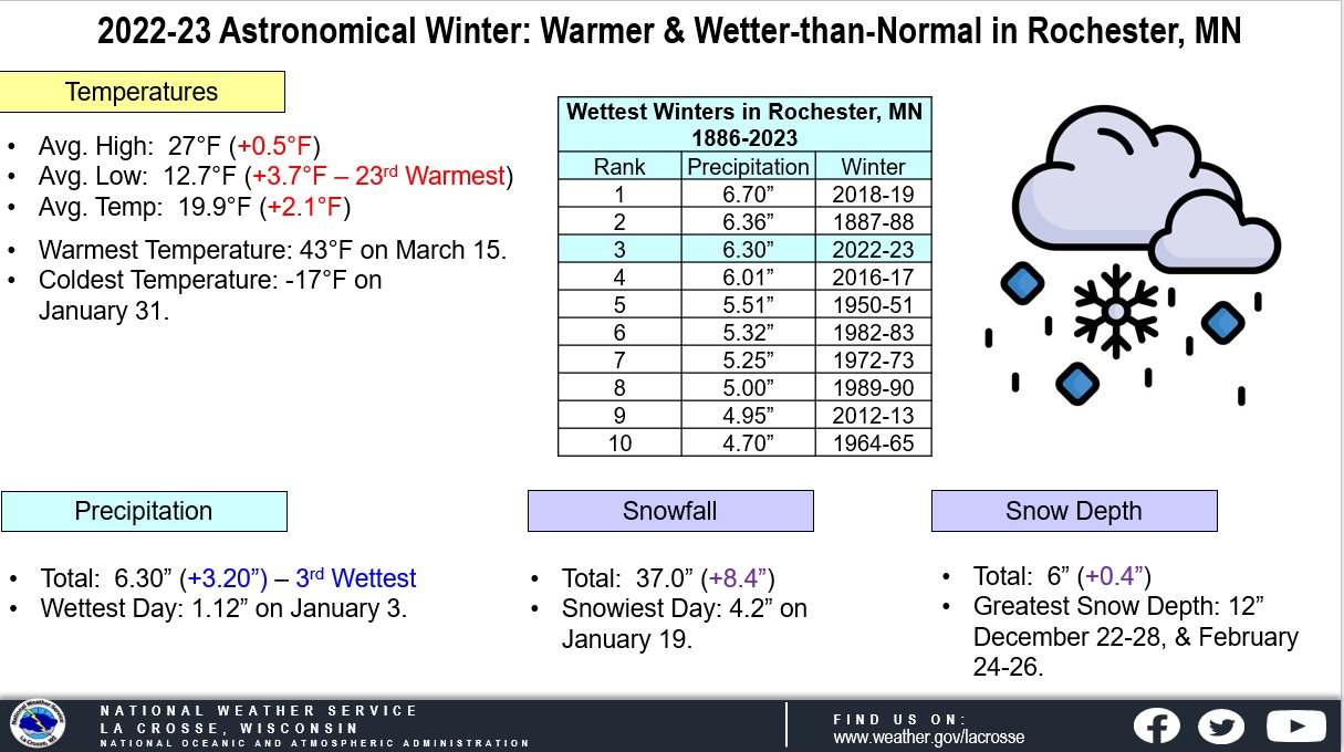 |
- The warmest high temperature was 43°F on March 15.
- The coldest high temperature was -5°F on December 23.
- The warmest low temperature was 35°F on February 14.
- The coldest low temperature was -17°F on January 31.
Precipitation - 3rd Wettest
- During astronomical winter, a total of 6.30" of precipitation fell at Rochester International Airport.
- This was 3.20" wetter than the long-term (1886-2023) average of 3.10".
- This was the wettest astronomical winter since 2018-2019 (6.70 inches - wettest winter).
Below are the ten wettest winters.
10 Wettest Astronomical
Winters for Rochester, MN
1886-2023
Rank Precipitation Winters
---- ------------- -------
1 6.70 inches 2018-19
2 6.36 inches 1887-88
3 6.30 inches 2022-23
4 6.01 inches 2016-17
5 5.51 inches 1950-51
6 5.32 inches 1982-83
7 5.25 inches 1972-73
8 5.00 inches 1989-90
9 4.95 inches 2012-13
10 4.70 inches 1964-65
- The wettest day occurred on January 3 when 1.12" of precipitation fell.
- Measurable (0.01 inches or greater) precipitation fell on 31 days (34.8%) and trace amounts of precipitation fell on another 21 days (23.6%).
Snowfall...22nd Snowiest
- During astronomical winter, a total of 37" of snow was measured by the official NWS snow observer near Rochester International Airport.
- This was 8.4" greater than the long-term (1909-2023) average of 28.6".
- This was the greatest amount of snow in an astronomical winter since 2018-19 (65.1 inches - snowiest winter).
- The snowiest day occurred on January 19 when 4.2" of snow fell.
- Measurable (0.1" or greater) snow fell on 25 days (28.1%) and trace amounts of snow fell on another 21 days (23.6%).
Snow Depth...30th Highest Average
- During astronomical winter, the average snow depth measured by the official NWS snow observer near Rochester International Airport was 6".
- This was 0.4" greater than the long-term (1938-2023) average of 5.6".
- This was the highest seasonal average snow depth in an astronomical winter since 2018-19 (9.9" - 12th greatest).
- Measurable snow was on the ground for 80 days or 69.9% of the season.
- A trace of snow was on the ground on 6 days or 6.7% of the season.
- There was no snow on the ground on 3 days or 3.4% of the season.
- The greatest snow depth was 12" from December 22 through December 28 and from February 24 through February 26.


 Weather Story
 Weather Map
 Local Radar