
Scattered thunderstorms with severe gusts, hail and a tornado risk are possible near a cold front from the Ohio Valley to the Mid-Atlantic tonight. Tropical Storm Bertha is expected to bring tropical storm conditions to portions of the Gulf Coast from the panhandle of Florida into Louisiana through Wednesday. Read More >
Overview
|
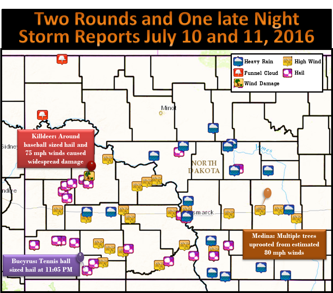
Severe storms across the southwest formed into a line and pushed east across south central and southeastern North Dakota for round one. The worst damage came occurred in Killdeer where golf ball to 3 inch diameter hail and 75 mph winds caused widespread damage, ripping siding from homes and shattering windows. Round two had several storms move northeast out of South Dakota while the line of storms moved through the James River Valley. These storms produced tennis ball sized hail in Bucyrus to 2 inch hail in Linton along with high winds. Both rounds of storms brought torrential rainfall with totals as high as 4.19 inches 4 miles west of Westfield. Street flooding occurred in Bismarck, Dickinson, and Jamestown from the intense rain. |
 Preliminary Storm Reports |
Storm Reports
...Hail Reports...

Location                     Size      Time/Date
Killdeer                     3.00 in   0500 PM 07/10
4 W Amidon                   2.75 in   0600 PM 07/10
Bucyrus                      2.50 in   1205 AM 07/11
Linton                       2.00 in   0112 AM 07/11
3 N Fairfield                1.75 in   0415 PM 07/10
6 SW Killdeer                1.75 in   0447 PM 07/10
3 N Manning                  1.75 in   0505 PM 07/10
10 S Kintyre                 1.75 in   0255 AM 07/11
6 ENE Pretty Butte           1.75 in   0452 PM 07/10
2 W Amidon                   1.75 in   0534 PM 07/10
8 NE Fairfield               1.50 in   0427 PM 07/10
Prairie Knights Resort       1.50 in   0205 AM 07/11
Amidon                       1.50 in   0550 PM 07/10
3 SW Fairfield               1.25 in   0413 PM 07/10
9 NE Bucyrus                 1.00 in   1220 AM 07/11
4 S South Fairfield          1.00 in   0432 PM 07/10
1 SSW Bismarck               1.00 in   0927 PM 07/10
New Leipzig                  1.00 in   0108 AM 07/11
3 SW Porcupine               1.00 in   0130 AM 07/11
10 SW New England            1.00 in   0608 PM 07/10
2 W Bowdon                   1.00 in   1023 PM 07/10
Linton                       0.88 in   0416 AM 07/11
5 SSW Strawberry Lake        0.88 in   0920 PM 07/10
Mandan                       0.88 in   0858 PM 07/10


...Wind Reports...

Location                     Speed     Time/Date
Medina                       80 MPH    1050 PM 07/10
Killdeer                     75 MPH    0526 PM 07/10
Mott                         75 MPH    0710 PM 07/10
4 N Fairfield                70 MPH    0415 PM 07/10
8 NW Twin Buttes             70 MPH    0545 PM 07/10
10 S Saint Gertrude          70 MPH    0857 PM 07/10
1 N Regent                   70 MPH    0645 PM 07/10
Mandan                       70 MPH    0856 PM 07/10
1 ENE Crown Butte Lake       70 MPH    0852 PM 07/10
5 WSW Glen Ullin             70 MPH    0738 PM 07/10
Bentley                      65 MPH    0745 PM 07/10
Steele                       65 MPH    1011 PM 07/10
2 E Hazen                    62 MPH    0815 PM 07/10
2 SSE Temvik                 61 MPH    0229 AM 07/11
14 N Haynes                  60 MPH    0725 PM 07/10
2 S Beulah                   60 MPH    0755 PM 07/10
2 NNW Solen                  60 MPH    0927 PM 07/10
Hebron                       60 MPH    0720 PM 07/10
6 ENE Pretty Butte           60 MPH    0452 PM 07/10
Ypsilanti                    60 MPH    1130 PM 07/10
6 S Dickinson                59 MPH    0644 PM 07/10
3 W Eldridge                 58 MPH    1110 PM 07/10
6 N Bismarck                 56 MPH    0901 PM 07/10
Stanton                      56 MPH    0815 PM 07/10
4 WNW Fryburg                55 MPH    0613 PM 07/10
Bismarck                     53 MPH    0917 PM 07/10
Linton                       50 MPH    1009 PM 07/10

Observations are collected from a variety of sources with varying
equipment and exposures. Not all data listed are considered official.
Rain Reports
...Rainfall Reports...

Location                     Amount    Time/Date
3 W Westfield                4.19 in   0824 AM 07/11
3 N Forbes                   3.00 in   0840 AM 07/11
3 S Hague                    2.60 in   0822 AM 07/11
7 NE Ashley                  2.25 in   0739 AM 07/11
Dickinson                    2.00 in   0800 PM 07/10
Hazelton                     2.00 in   0821 AM 07/11
2 NE Strawberry Lake         1.75 in   0632 AM 07/11
3 SSE Selz                   1.61 in   0844 AM 07/11
Richardton                   1.59 in   1008 AM 07/11
Baldwin                      1.50 in   0847 AM 07/11
2 NE Bismarck                1.42 in   0955 PM 07/10
Carrington                   1.30 in   0837 AM 07/11
Jamestown                    1.30 in   1020 AM 07/11
Chaseley                     1.23 in   0838 AM 07/11
Bismarck                     1.21 in   1016 AM 07/11
Harvey                       1.15 in   0915 AM 07/11
1 W Garrison                 1.10 in   1019 AM 07/11
6 SW Orrin                   1.01 in   0817 AM 07/11
 |
Media use of NWS Web News Stories is encouraged! Please acknowledge the NWS as the source of any news information accessed from this site. |
|

