
Widespread, life-threatening considerable flash flooding is expected in south-central Texas through at least Friday. Catastrophic river flooding and rapid rises on small streams, arroyos, and typically dry washes are expected in the Texas Hill Country. Wildfire smoke is impacting air quality across much of the Great Lakes region into the Northeast U.S. with Air Quality Alerts in effect. Read More >
Overview
|
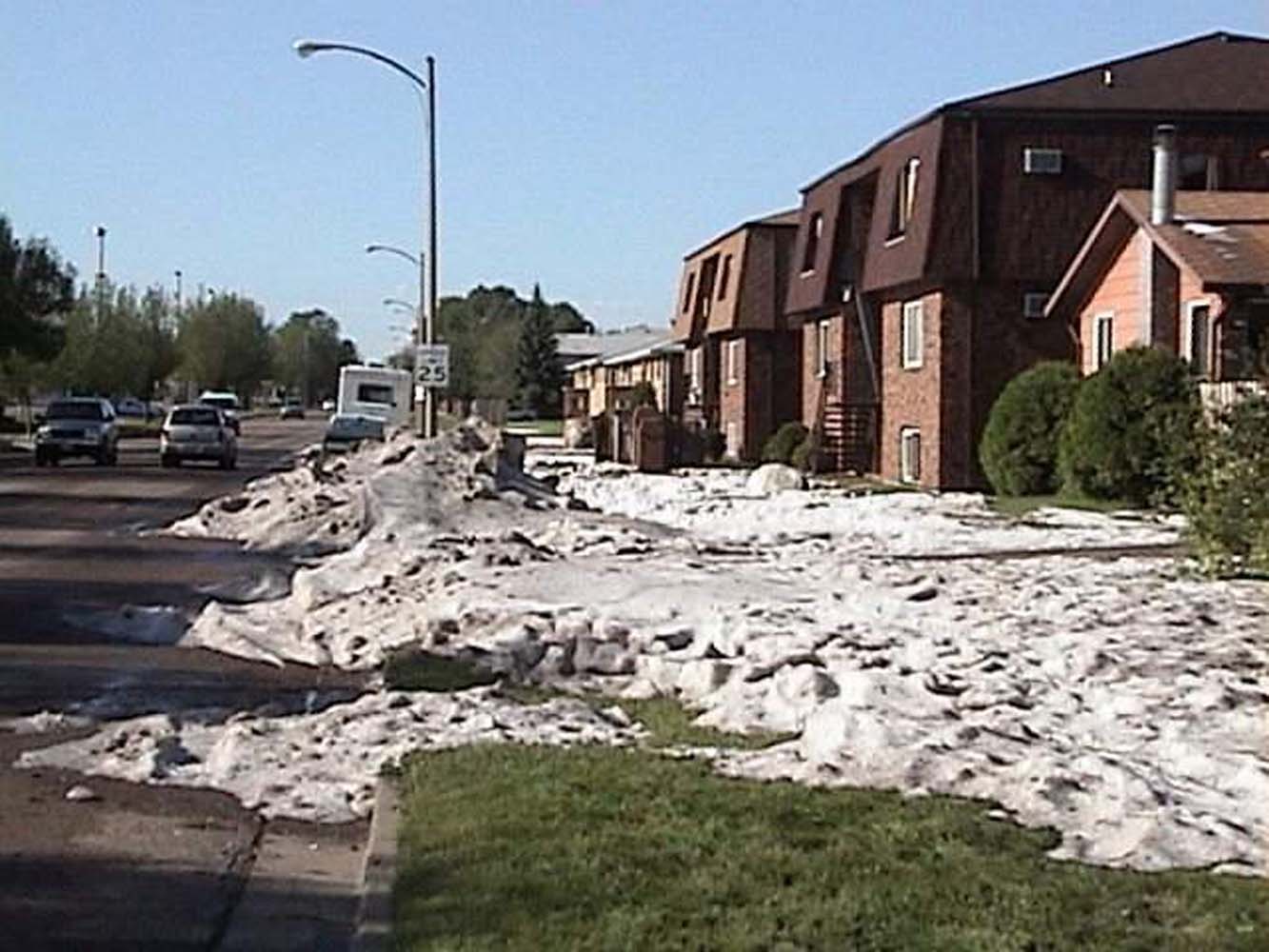
On June 9, 2001, severe thunderstorms with an incredible amount of hail caused significant damage to homes and vehicles across the Bismarck and Mandan areas. Estimated damage from the hail in the two cities amounted to around $260 million. An approaching upper level storm system provided lift to produce severe thunderstorms over much of central North Dakota that Saturday afternoon and evening. Abundant low level moisture combined with relatively cool air aloft led to the formation of a substantial amount of hail with many of these storms. What was especially unusual is that there were 3 rounds of storms that moved through, 30 to 40 miles apart from each other. Many overpasses in the city were flooded from heavy rain and the large amount of hail. The largest hail reported was baseball size (2.75") in Mandan, with golf ball size hail (1.75") in Bismarck. Additionally, very heavy rainfall caused flash flooding in Bismarck where a foot or more of water covered some roads. Up to 12 feet of water accumulated in the railroad underpasses in town, with large amounts of hail contributing to blocked roads. Large hail also fell over Hettinger, Dunn, Oliver, Stark, McIntosh, and Kidder counties. Six miles southeast of Menoken on a farm, golf ball size hail lasted 30 minues, injured a large number of livestock, and smashed out vehicle windows. Numerous reports of funnel clouds accompanied the storms in Bismarck, and one confirmed F1 tornado touched down 9 miles northwest of Hazelton in Emmons county. A vehicle on highway 83 was thrown into a ditch, injuring the driver. In addition to the rain, hail, and funnel clouds, widespread wind damage was reported across the area. A roof was lifted off a home in Oliver county, and multiple grain bins were destroyed in Emmons county along with numerous barns and farm homes in rural areas. An estimated 87 mph gust occured in Napoleon, where a roof was blown off a business, and mature trees uprooted. |
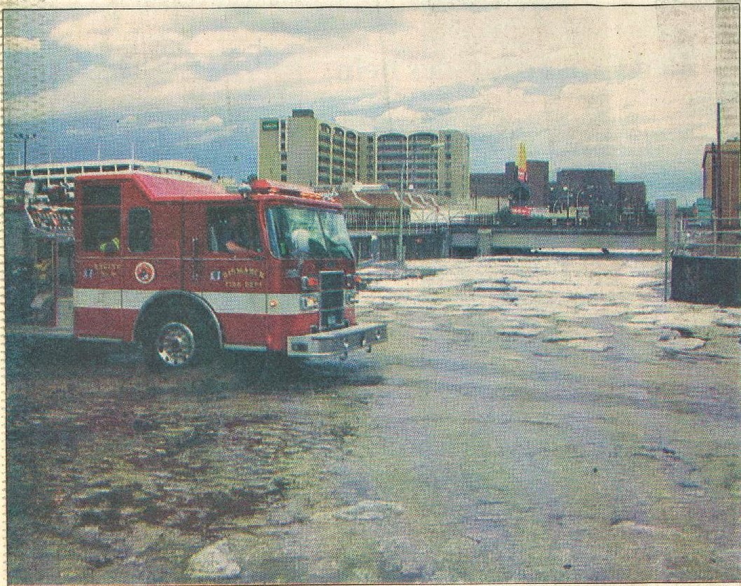
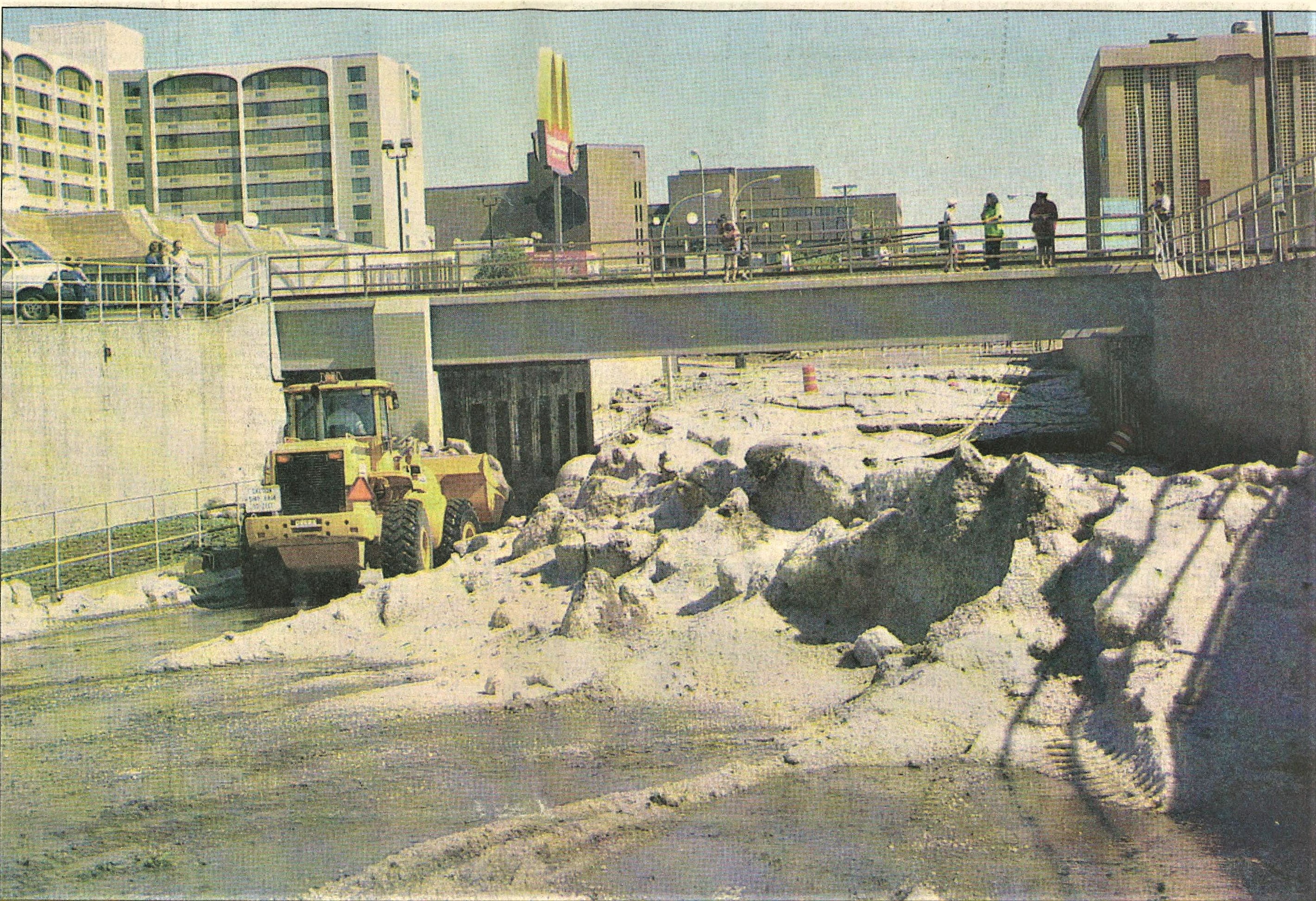 A payloader clears the river of ice from the Seventh Street underpass (Bismarck Tribune) |
Timeline:
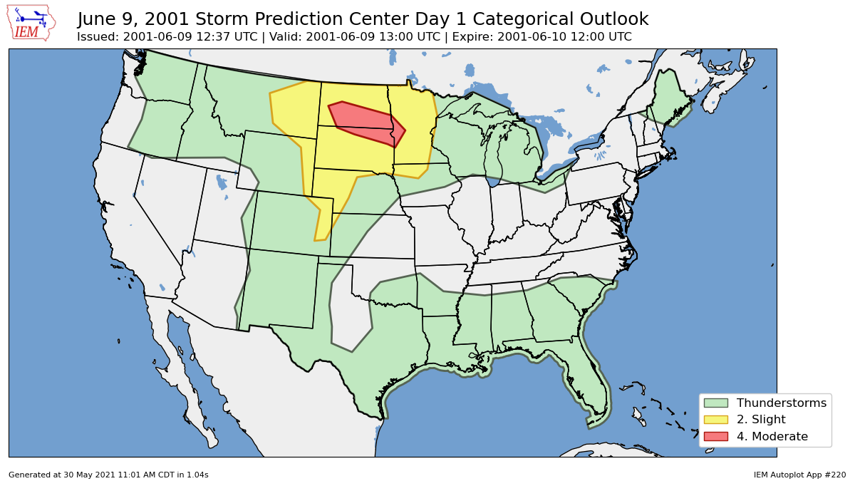
12:56 AM CDT: SPC issues the latest Day 1 Convective Outlook that includes a Moderate Risk of severe thunderstorms over portions of the Dakotas and into western Minnesota. The discussion mentions damaging wind and large hail as the primary threats, but that a few tornadoes are also possible during the late afternoon/early evening along the North Dakota / South Dakota border.
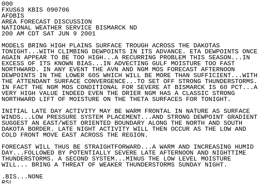
2:00 AM CDT: The morning Area Forecast Discussion from NWS Bismarck discusses a "straightforward" forecast, with potentially severe late afternoon and nighttime thunderstorms.
12:06 PM CDT: SPC issues a Mesoscale Discussion for eastern Montana and western North Dakota concerning severe thunderstorm potential, as convection begins to intensify.
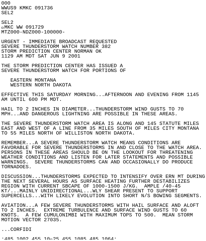
12:29 PM CDT: A Severe Thunderstorm Watch is issued for portions of eastern Montana and western North Dakota until 7:00 PM CDT. Threats are hail to 2 inches in diameter, thunderstorm wind gusts to 70 mph, and dangerous lightning.
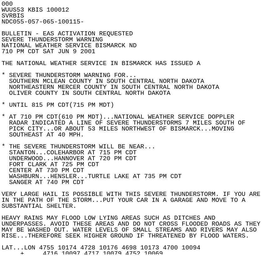
2:33 PM CDT: SPC issues a Mesoscale Discussion concerning the current Severe Thunderstorm Watch, noting that another watch may be required downstream as convection is expected to gradually increase through the afternoon.
2:58 PM CDT: SPC issues another Mesoscale Discussion mainly for areas in southern Montana and northeastern Wyoming, but mentions that thunderstorms could move into southwestern North Dakota.
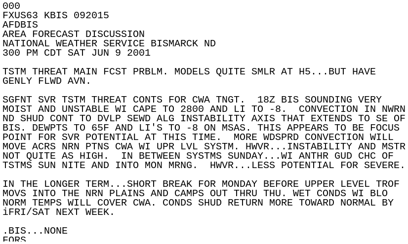
3:00 PM CDT: The AFD is updated, discussing a significant severe thunderstorm threat for the forecast area through the evening. A special 18Z sounding was done at KBIS that showed a very moist and unstable environment.
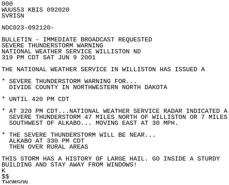
3:19 PM CDT: The WSO in Williston issues a Severe Thunderstorm Warning for Divide County until 4:20 PM.
3:20 PM CDT: Nickel sized hail is reported in Alkabo.
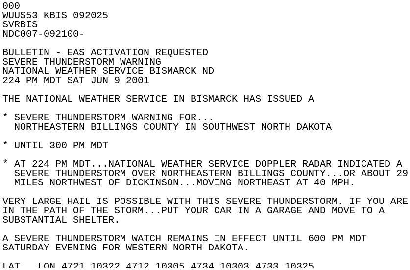
3:26 PM CDT: A Severe Thunderstorm Warning is issued for northeast Billings County until 4:00 PM.
3:31 PM CDT: A Tornado Watch is issued for portions of western Montana, and western and southern North Dakota until 11 PM.
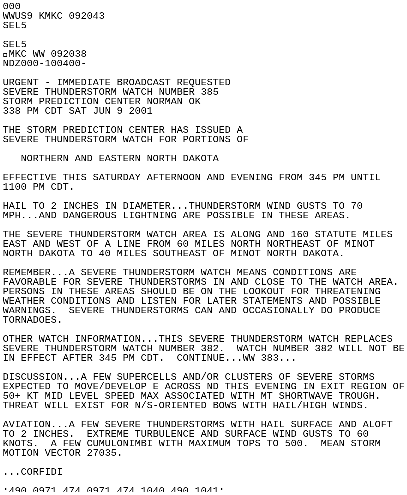
3:38 PM CDT: Another Severe Thunderstorm Watch is issued for portions of northern and eastern North Dakota, effective until 11 PM.
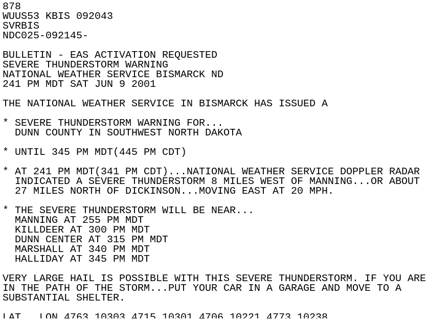
3:41 PM CDT: A Severe Thunderstorm warning is issued for Dunn County until 4:45 PM.
4:00 PM CDT: 2 inch hail is reported 10 miles south of Manning in Dunn County.
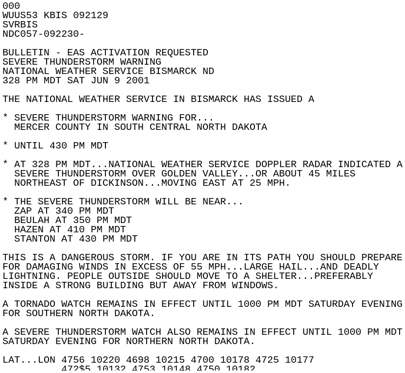
4:38 PM CDT: A Severe Thunderstorm Warning is issued for Mercer County until 5:30 PM. This is noted as being a dangerous storm.
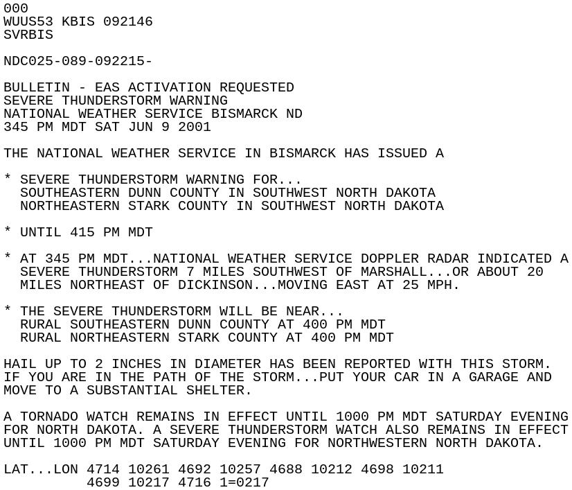
4:45 PM CDT: A Severe Thunderstorm Warning is issued for southeastern Dunn and northeastern Stark Counties until 5:15 PM. Hail up to 2 inches in diameter has been reported with this storm.
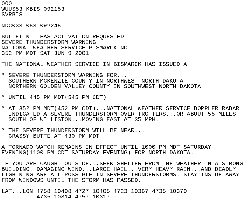
4:52 PM CDT: A Severe Thunderstorm Warning is issued for southern McKenzie and northern Golden Valley Counties until 5:45 PM.
4:57 PM CDT: A Tornado Warning is issued for southeastern Mercer and western Oliver Counties until 5:30 PM. The tornado is radar indicated.
5:00 PM CDT: A funnel cloud is reported 5 miles south of Beulah.
5:10 PM CDT: Estimate thunderstorm wind gust of 75 mph 6 miles northeast of Center, where a farm home and machinery were damaged.
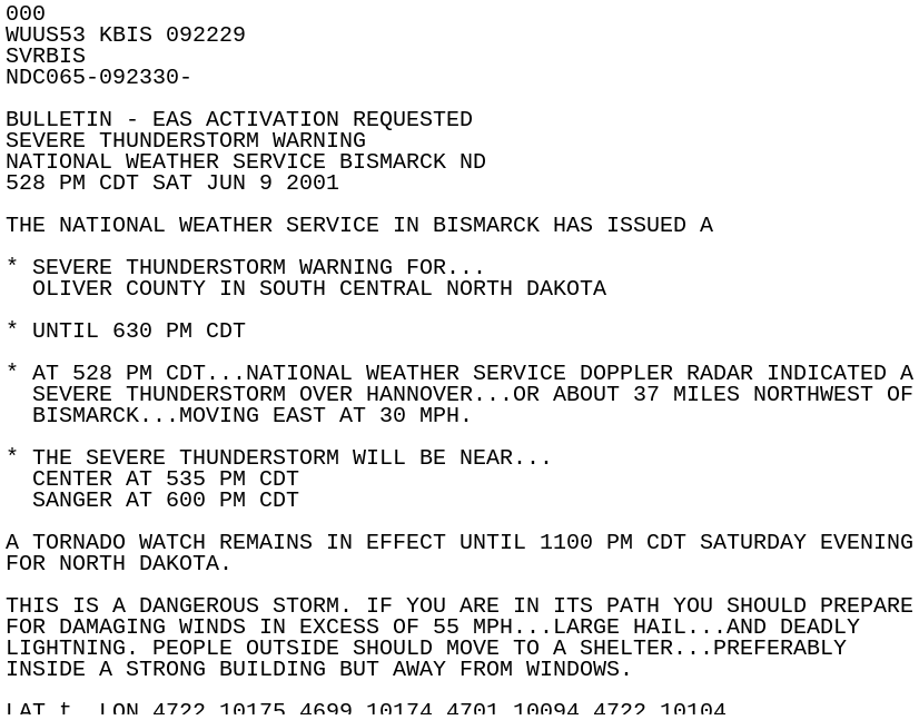
5:28 PM CDT: A Severe Thunderstorm Warning is issued for Oliver County until 6:30 PM CDT.
5:35 PM CDT: 1.75 inch hail is reported 3 miles west of Center.
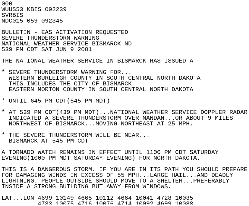
5:39 PM CDT: A Severe Thunderstorm Warning is issued for western Burleigh and eastern Morton Counties until 6:45 PM. This includes the city of Bismarck, and is noted as being a dangerous storm.
5:40 PM CDT: 1.75 inch hail reported 4 miles northeast of Mandan.
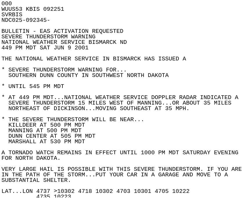
5:49 PM CDT: A Severe Thunderstorm Warning is issued for southern Dunn County until 6:45 PM. Very large hail is possible with this thunderstorm.
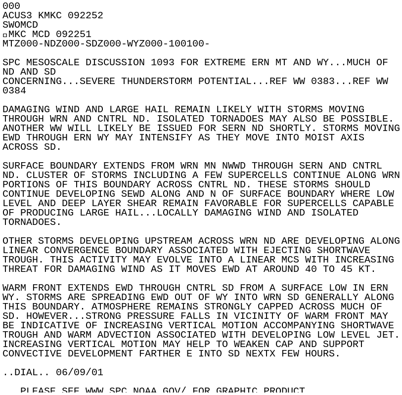
5:52 PM CDT: SPC issues a Mesoscale Discussion for much of the Dakotas. Damaging wind and large hail remain likely with storms moving through western and central North Dakota, and isolated tornadoes may also be possible.
5:55 PM CDT: 2.75 inch hail reported in Mandan. 1.75 inch hail reported 3 miles north of Bismarck.
6:00 PM CDT: Numerous reports of funnel clouds in Bismarck with the storm.
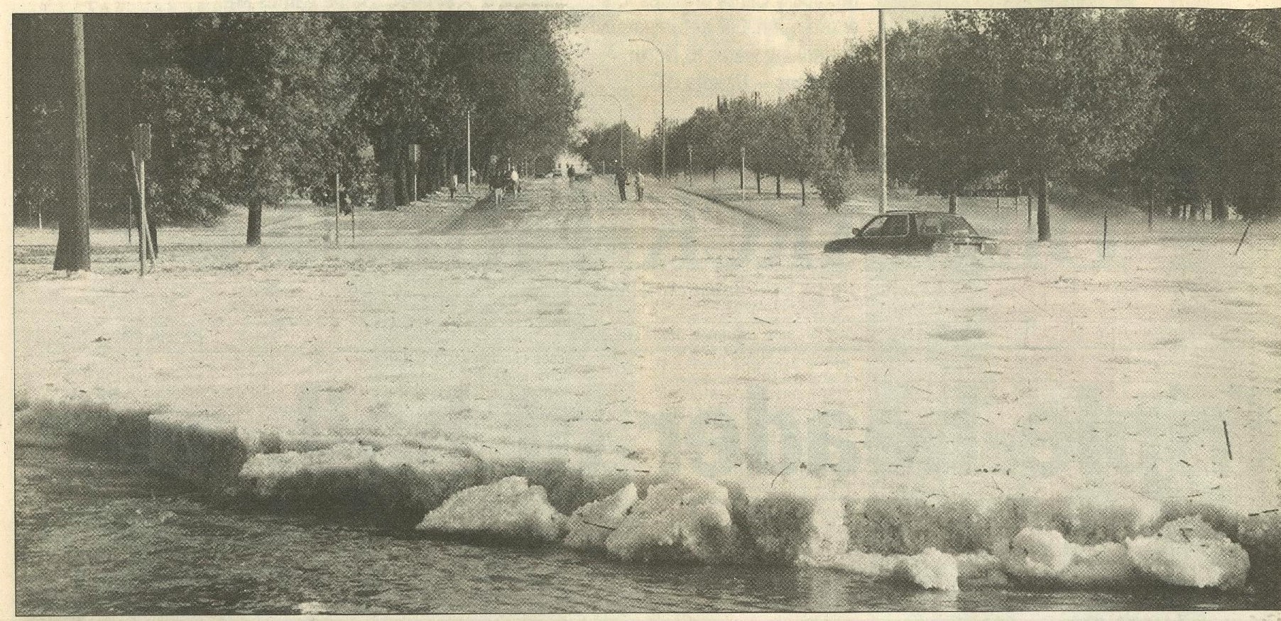
6:15 PM CDT: Widespread street flooding reported throughout the city of Bismarck where a foot of water or more covered the roads. Travel was not advised. Up to 12 feet of water accumulated in the railroad underpasses in town.
6:21 PM CDT: A funnel cloud was reported 3 miles west of Steele.
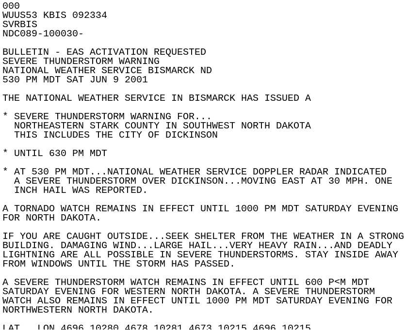
6:30 PM CDT: A Severe Thunderstorm Warning is issued for northeastern Stark County until 6:30 PM. This includes the city of Dickinson. 1 inch hail was reported in Dickinson.
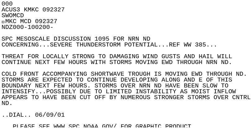
6:37 PM CDT: SPC issues a Mesoscale Discussion for the severe thunderstorm potential in northern North Dakota, nothing that storms have been slow to intensify, possibly due to limited instability with moist inflow being cut off by the stronger storms over central North Dakota.
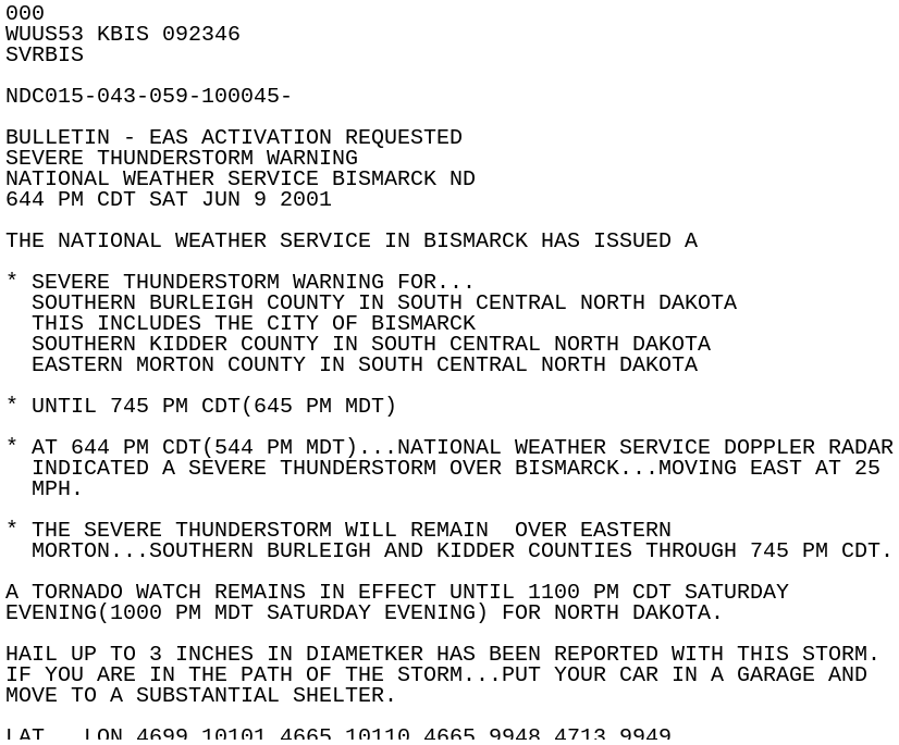
6:44 PM CDT: A Severe Thunderstorm Warning is issued for southern Burleigh, southern Kidder, and eastern Morton Counties until 7:45 PM. This includes the city of Bismarck. Hail up to 3 inches in diameter has been reported with this storm.
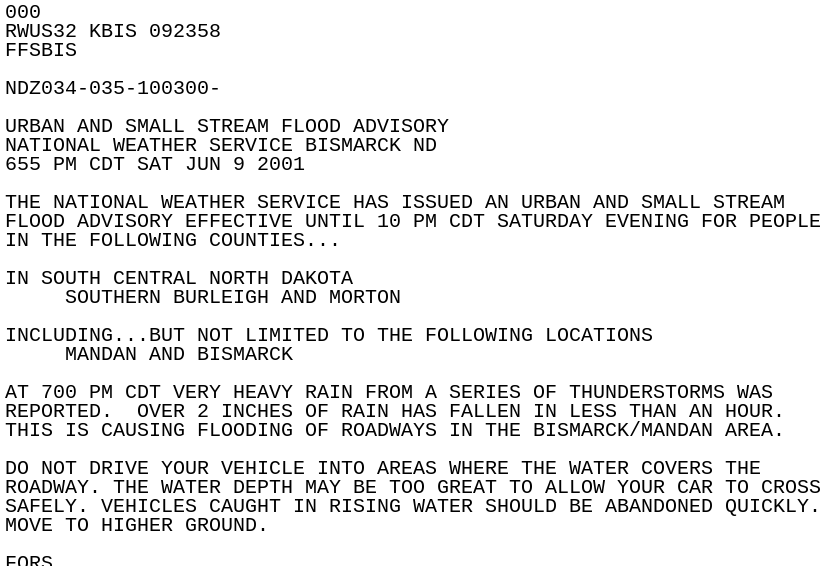
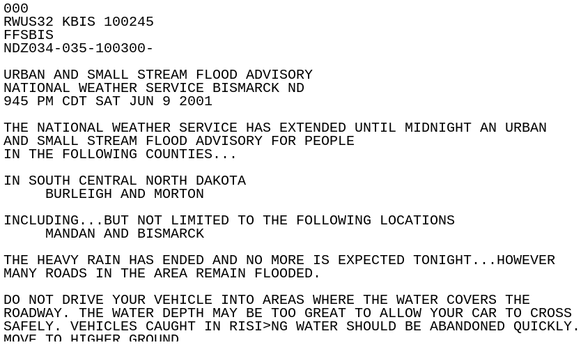
6:55 PM CDT: An Urban and Small Stream Flood Advisory is issued for southern Burleigh and Morton Counties until 10 PM. This includes the cities of Bismarck and Mandan, with flooded roadways reported in the area.
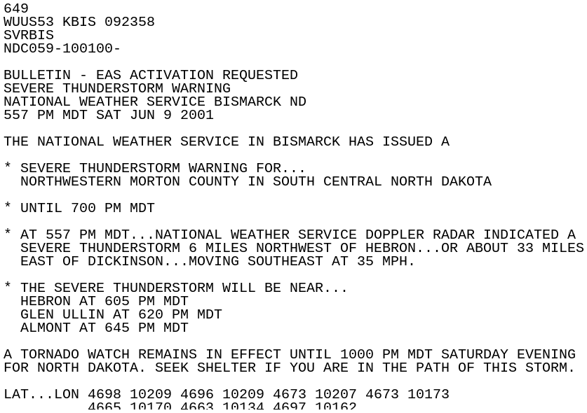
6:57 PM CDT: A Severe Thunderstorm Warning is issued for northwestern Morton County until 8:00 PM.
7:06 PM CDT: A Severe Thunderstorm Warning is issued for northern Emmons County until 8:00 PM.
7:10 PM CDT: A Severe Thunderstorm Warning is issued for southern McLean, northeastern Mercer, and Oliver Counties until 8:15 PM. Winds were estimated at 69 mph 7 miles north-northwest of Hazelton, where there was major damage to a barn.
7:10 PM - 7:25 PM CDT: An F1 tornado tracked from 9 miles northwest of Hazelton to 2 miles east of Hazelton. Drivers along Highway 83 witnessed a vehicle drive into the path of the tornado. The vehicle was thrown into the ditch, injuring the driver. Other damage by the tornado includes four power lines down along Highway 83, and tops of evergreen trees snapped off.
7:15 PM CDT: 2 inch hail reported 6 miles southeast of Menoken. Resident at a farm reported the hail lasted 30 minutes and was mostly golf ball size. The hail injured a large number of his livestock, smashed vehicle windows and wiped out most of the crops.
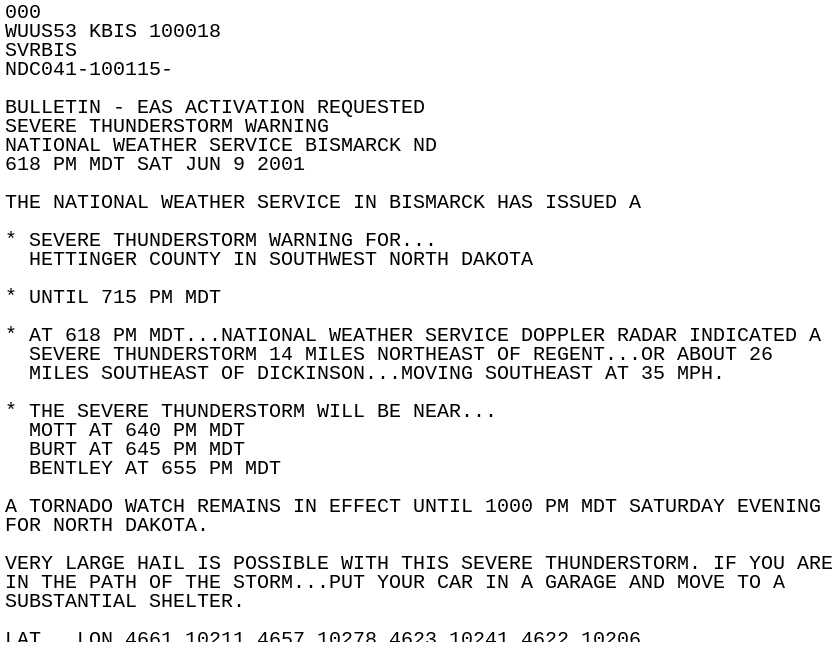
7:18 PM CDT: A Severe Thunderstorm Warning is issued for Hettinger County until 8:15 PM.
7:70 PM CDT: Estimated thunderstorm wind gust of 80 mph 7 miles northeast of Center. A 10 foot section of a roof was lifted off a home, a mobile home had wind and hail damage, and the top of a camper was completely destroyed.
7:25 PM CDT: Estimated thunderstorm wind gust of 85 mph in Hazelton, with major damage done to homes and businesses in the area. One 25,000-bushel grain bin, five 5,000-bushel grain bins, four stor-all-bins and a fertilizer storage bin were destroyed. The wind and hail destroyed or damaged numerous barns, pole buildings, farm homes, crops, and hay land in rural areas. High winds downed power lines and overturned one car.
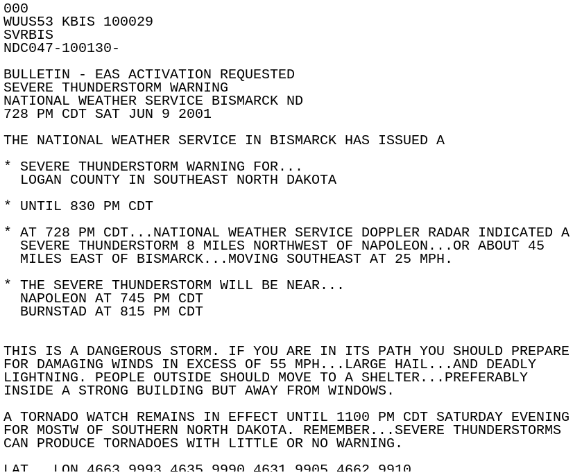
7:28 PM CDT: A Severe Thunderstorm Warning is issued for Logan County until 8:30 PM. This is noted as being a dangerous storm.
7:34 PM CDT: 1 inch hail is reported in Glen Ullin.
7:40 PM CDT: 1.75 inch hail is reported 14 miles north of Burt.
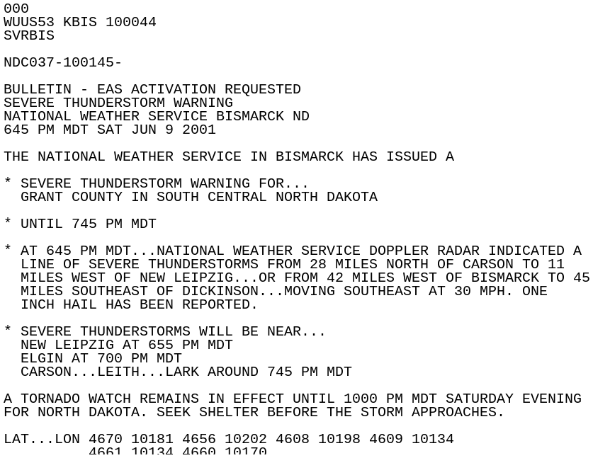
7:45 PM CDT: A Severe Thunderstorm Warning is issued for Grant County until 8:45 PM.
8:00 PM CDT: 1 inch hail is reported in Elgin.
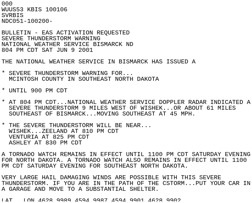
8:04 PM CDT: A Severe Thunderstorm Warning is issued for McIntosh County until 9:00 PM.
8:10 PM CDT: Estimated thunderstorm wind gust of 100 mph in Napoleon, with a roof blown off a business and mature trees uprooted.
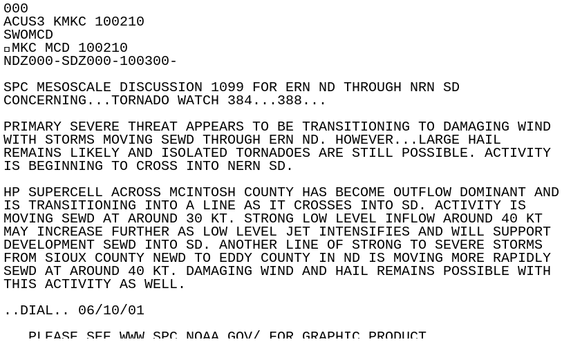
8:21 PM CDT: SPC issues a Mesoscale Discussion about the Tornado Watch and supercells moving through Logan and McIntosh Counties.
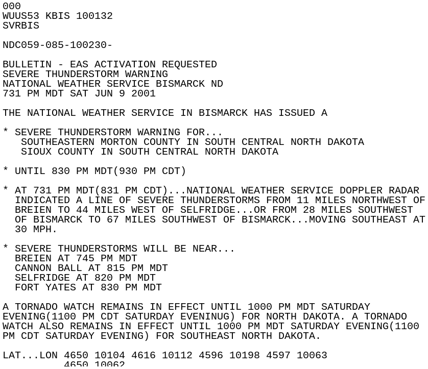
8:31 PM CDT: A Severe Thunderstorm Warning is issued for southeastern Morton and Sioux Counties until 9:30 PM.
8:36 PM CDT: A funnel cloud was reported 4 miles east of Bismarck.
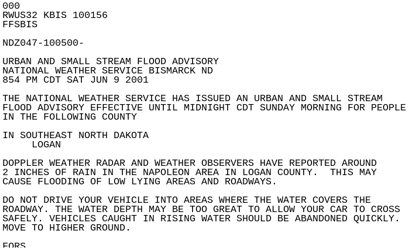
8:54 PM CDT: An Urban and Small Stream Flood Advisory is issued for Logan County until 12:00 AM.
8:40 PM CDT: Estimated thunderstorm wind gust of 75 mph in Lehr. Several homes in town were damaged with large trees uprooted. Campers were overturned, a cabin was completely destroyed at Beaver Lake State Park, and one camper was blown over into Beaver Lake.
8:45 PM CDT: 2.75 inch hail reported in Ashley, with widespread auto and roof damage throughout the city.
8:59 PM CDT: A Severe Thunderstorm Warning is issued for western Dickey and eastern McIntosh Counties until 9:45 PM.
9:00 PM CDT: Estimated wind gust around 65 mph in Wishek, with several large trees uprooted and a street light pole snapped off.
9:10 PM CDT: One last Mesoscale Discussion for us is issued by SPC, as storms are exiting the forecast area and moving into South Dakota.
9:30 PM CDT: Estimated thunderstorm wind gust of 85 mph in Oakes. Empty railroad cars were moved down the tracks by the wind, a large garbage dumpster was blown down a street, a roof was blown off a building, and numerous trees were uprooted.
9:45 PM CDT: The Flood Advisory for Burleigh and Morton Counties is extended until midnight, as many roads in the area remain flooded.
Photos & Video
Header
 |
 |
 |
 |
| The Seventh Street railroad underpass filled with hail and water. (Bismarck Tribune) |
A vehicle stuck in the icy mix on North Washington Street. (Bismarck Tribune) |
Hail fills the street at 7th Street in Bismarck. |
Hail fills the street at 7th Street in Bismarck. (State Historical Society of North Dakota Collection #32228 Item #00006-00001-00004j) |
 |
 |
 |
 |
| Yards on Turnpike Avenue in Bismarck are covered in hailstones. (State Historical Society of North Dakota Collection #32228 Item #00006-00001-00004k) |
Large piles of hail clump together in the 9th Street underpass in Bismarck. (State Historical Society of North Dakota Collection #32228 Item #00006-00001-00004q) |
A man takes a photograph from the corner of 7th Street and Main Avenue in Bismarck. (State Historical Society of North Dakota Collection #32228 Item #00006-00001-00004r) |
A parked car sits surrounded by hail in the McDonald's parking lot on Main Avenue in Bismarck. (State Historical Society of North Dakota Collection #32228 Item #00006-00001-00004s) |
 |
 |
 |
 |
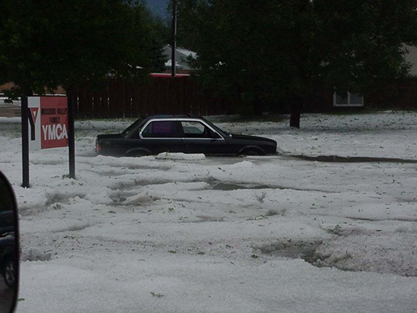
| A cat sits surrounded by hail in the parking lot of the YMCA in Bismarck. (State Historical Society of North Dakota Collection #32228 Item #00006-00001-00004w ) |
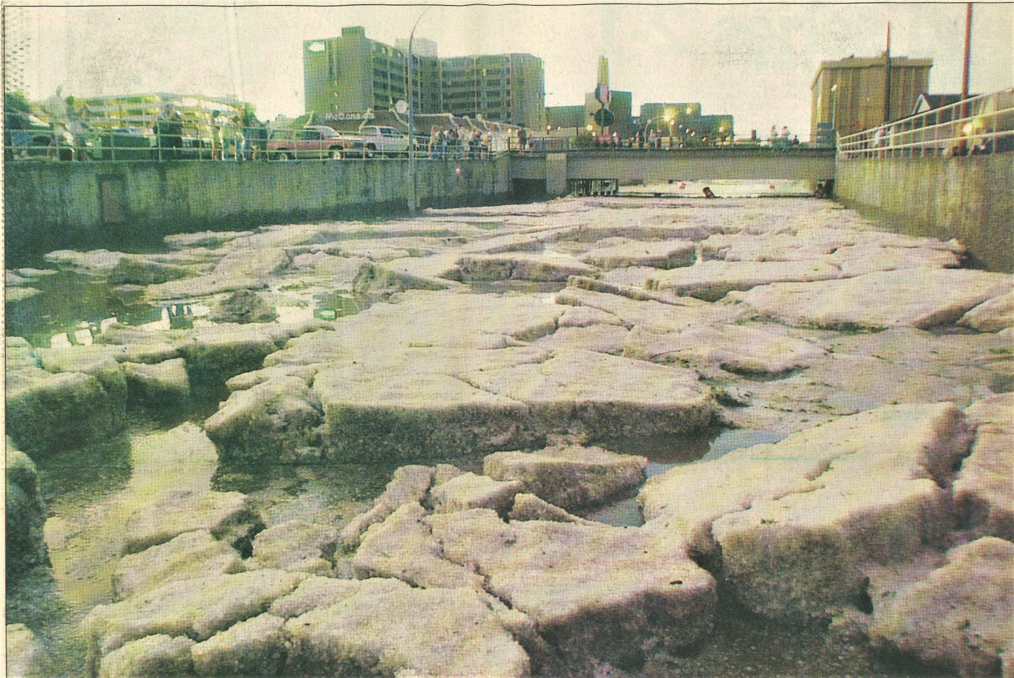
The underpass at Seventh Street and Front Avenue was filled with water and ice from the storms. (Bismarck Tribune) |
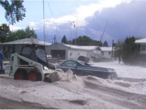
A bulldozer moves piles of hail in the road. (State Historical Society of North Dakota Collection #32228 Item #00006-00001-00004bb) |
Aftermath of the hailstorm. (Storm Data) |
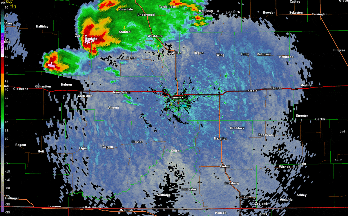
Radar
Radar imagery from KBIS shows three separate waves of storms that moved through south central North Dakota during the afternoon and evening of June 9.
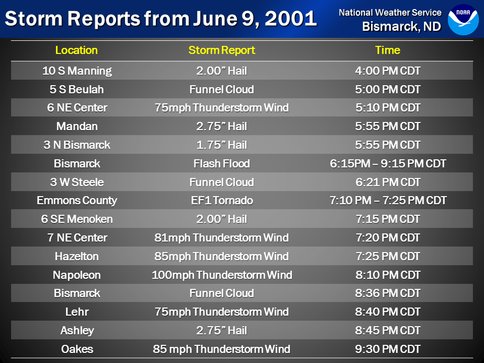
Storm Reports
Select storm reports from June 9. For a full list of reports, visit our storm data page.
Environment
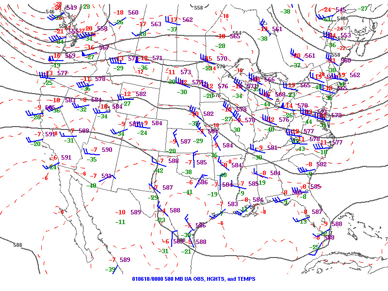
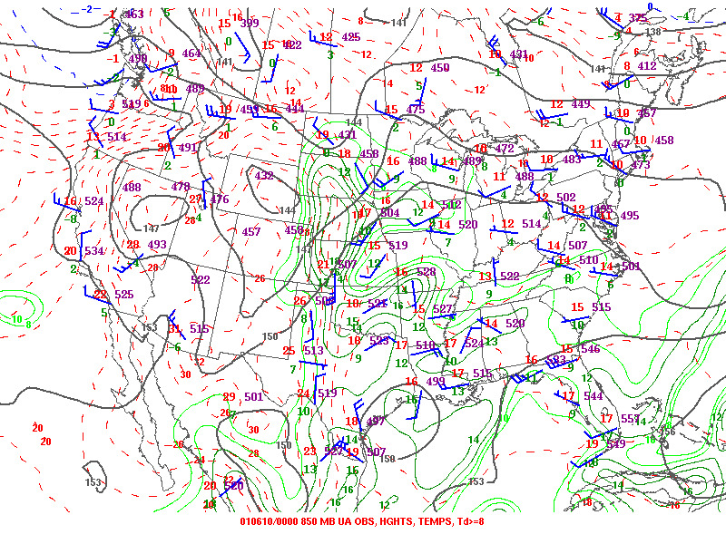
An approaching upper level storm system helped provide lift for thunderstorms on June 9th, as seen on the 500mb upper air map (Figure 1). There was abundant low level moisture, seen by the green contours on the 850mb map (Figure 2), which is a big reason why there was such an abundance of hail with these thunderstorms. At the surface (Figure 3), a warm front was lifting north through the Dakotas, which also helped provide lift and moisture to the environment.
 |
 |
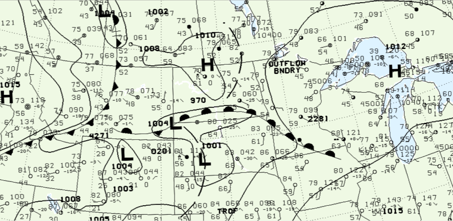 |
| Figure 1: 500 mb height map | Figure 2: 850 mb height map | Figure 3: Surface analysis map |
 |
Media use of NWS Web News Stories is encouraged! Please acknowledge the NWS as the source of any news information accessed from this site. |
|

