
A significant heat wave continues for the Rockies, Northern Plains, and Great Lakes into the Mid-Atlantic, peaking in intensity through midweek and lingering across parts of the Northern Plains and Midwest until this weekend. Excessive rainfall my bring life-threatening and locally catastrophic flash and urban flooding across portions of southwestern Texas through early Friday. Read More >
Overview
|
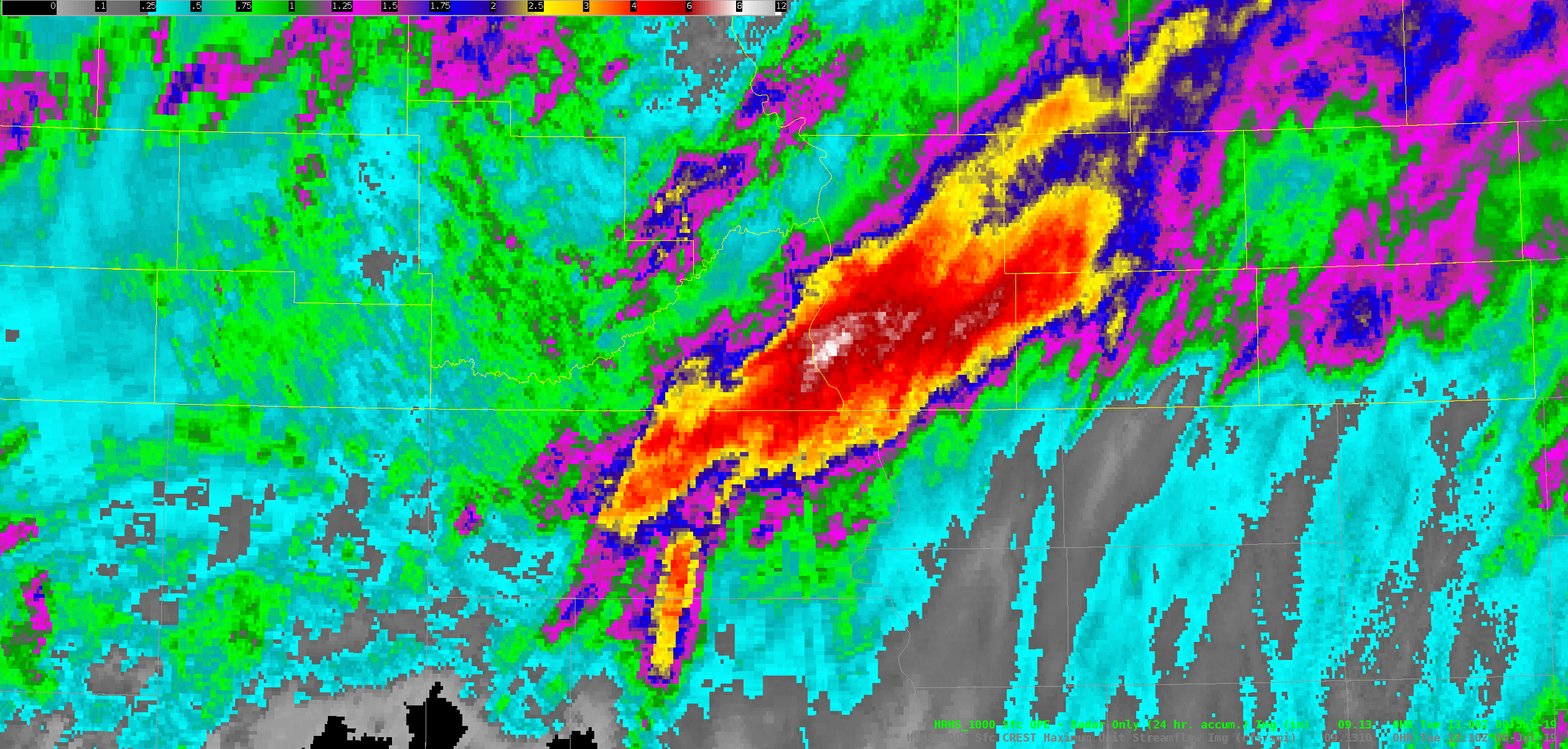
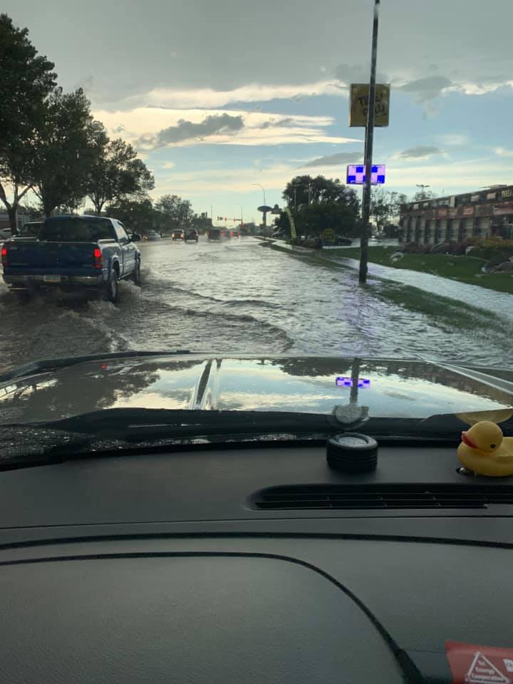
Widespread heavy rain occurred across western and central North Dakota on July 8th through July 9th, 2019 as a slow moving low pressure system moved through the area. Heavy rain was mainly the result of thunderstorms with very high rain rates, training over the same areas for several hours. Flash flooding occurred in areas where the heaviest rainfall amounts were observed within the shortest period of time, mainly across Sioux and Emmons counties. In fact, some areas in Emmons County measured over 6 inches of rain on the 8th. Amounts were similar in portions of Sioux County, where radar estimated rainfall amounts as high as 8 inches were observed. This is more than half of the average annual rainfall in these areas. It is also worth noting that this same area received several inches of rain about one week prior, on July 3rd. High soil moisture and additional heavy rain on the 8th led to flash flooding in these areas, which contributed to a very deep road washout on Route 1806 south of Fort Yates in Sioux County. Unfortunately, this created a dangerous situation for people driving along this road, and sadly led to two fatalities and two injuries. These are the first ever documented fatalities associated with flash flooding in Sioux County. The city of Bismarck also experienced flash flooding on July 8th as approximately 1.5 to 2.0 inches of rain fell within a mere 30 minutes across portions of the metro area. Although this amount of rain wasn't nearly as much as what fell further south, this was enough to cause flash flooding in an urban area and led to dangerous driving conditions. Flooding was also reported in the Southern James River Valley and portions of northwest and north central North Dakota on July 9, 2019. These areas received impressive rainfall reports as well, mainly between 2 and 6 inches. This rain fell over a longer duration compared to the rain that fell over Sioux and Emmons counties on July 8th. |
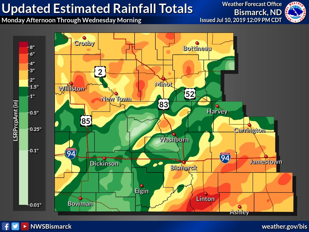 Estimated Rainfall Totals from Reports Received |
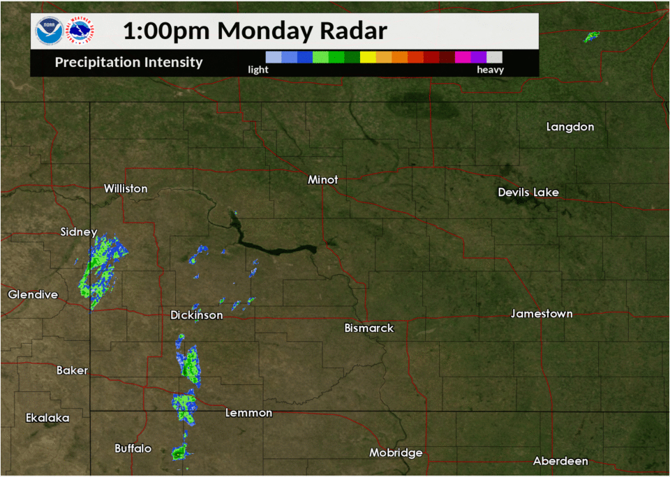
Radar
 |
 |
 |
 |
|
Radar Loop for July 8th-July 9th, 2019 showing widespread heavy rain. |
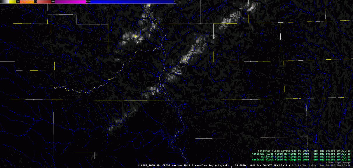
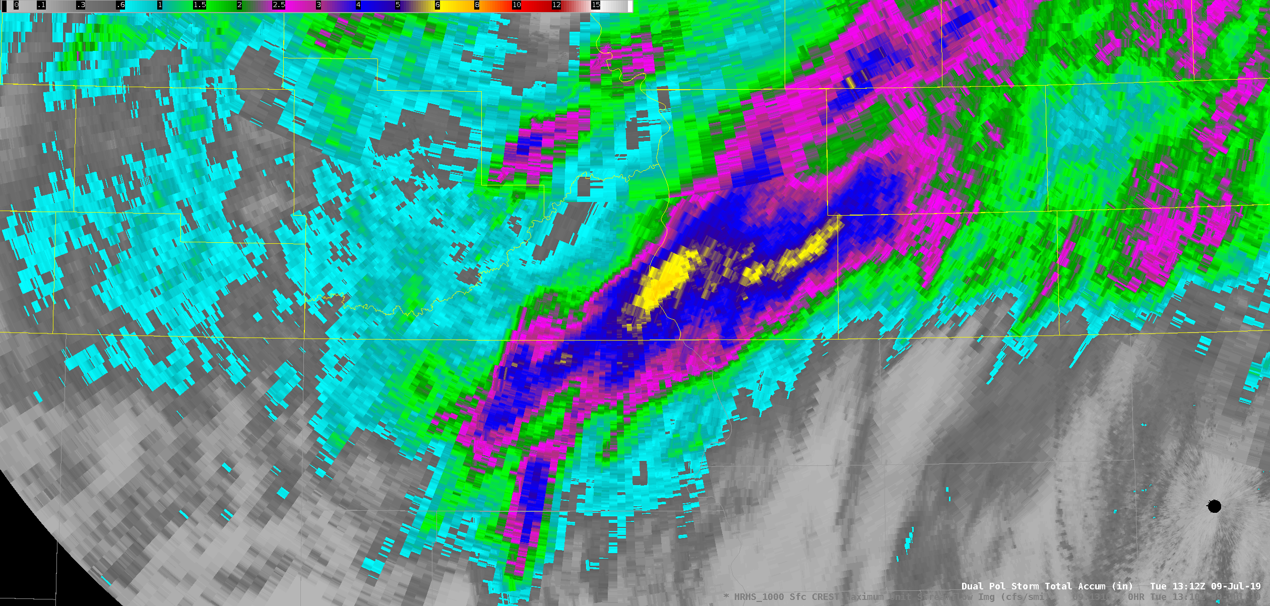
Multi-Radar/Multi-Sensor (MRMS) CREST Max Unit Streamflow Loop. Yellow, orange, and red colors highlight areas that experienced the most significant flash flooding. | Dual-Pol Storm Total Rainfall Estimate. Notice values over parts of Sioux and Emmons counties exceed 6 inches. | MRMS Storm Total Rainfall Estimate. Notice values approaching 8 inches across portions of Sioux and Emmons counties. |
Photos & Video
Header
 |
 |
 |
 |
| Courtesy of the Bureau of Indian Affairs. This photo shows the washout that occurred on Route 1806 south of Fort Yates in Sioux County. |
Courtesy of KX News. Vehicle and camper in flood waters downstream from the washout that occurred on Route 1806. | Courtesy of KX News. This is a side view of the washout that occurred on Route 1806. |
Courtesy of Alan Aamold, showing street flooding within the Bismarck metro area after storms ended. |
Storm Reports
..TIME... ...EVENT... ...CITY LOCATION... ...LAT.LON...
..DATE... ....MAG.... ..COUNTY LOCATION..ST.. ...SOURCE....
..REMARKS..
0345 PM Heavy Rain ANAMOOSE 47.89N 100.24W
07/08/2019 M2.30 inch McHenry ND Public
.
0418 PM Heavy Rain UNDERWOOD 47.46N 101.14W
07/08/2019 M3.10 inch McLean ND Public
.
0530 PM Flash Flood 1 WNW BISMARCK 46.81N 100.80W
07/08/2019 Burleigh ND NWS Employee
WATER WAS BEGINNING TO OVERFLOW THE CURBS
ALONG AVENUE C NEAR DOWNTOWN BISMARCK.
0602 PM Flash Flood 1 SW BISMARCK 46.80N 100.80W
07/08/2019 Burleigh ND Public
PICTURE POSTED ON FACEBOOK OF FLASH FLOODING
ON INDIANA AVE WEST OF WASHINGTON STREET IN
BISMARCK. WATER IS FLOWING OVER THE CURBS ON
BOTH SIDES OF THE ROAD.
0607 PM Heavy Rain 5 NNE Saint Anthony 46.68N 100.89W
07/08/2019 M3.85 inch Morton ND Trained Spotter
3.85 inches of rain in one hour. The Little
Heart River is flowing backwards due to the
heavy rainfall. Pea to quarter size hail
also reported.
0618 PM Heavy Rain 4 WSW LINCOLN 46.74N 100.78W
07/08/2019 M2.80 inch Burleigh ND Public
BROADCAST MEDIA PARTNER RELAYED RAINFALL
REPORT.
0647 PM Heavy Rain 7 S SAINT ANTHONY 46.52N 100.91W
07/08/2019 M2.25 inch Morton ND Public
.
0700 PM Heavy Rain 3 SSE BISMARCK 46.77N 100.76W
07/08/2019 E1.55 inch Burleigh ND NWS Employee
RAIN HAD ENDED AT THE TIME OF OBSERVATION.
0746 PM Heavy Rain 3 SSE TEMVIK 46.34N 100.23W
07/08/2019 M3.03 inch Emmons ND Public
.
1034 PM Flood FULLERTON 46.17N 98.43W
07/08/2019 Dickey ND Public
4-FOOT DITCH OVERFLOWING INTO THE STREET AND
DRIVEWAYS. RELAYED VIA PICTURE ON SOCIAL
MEDIA. STILL RAINING AS OF THIS REPORT.
1100 PM Flash Flood 4 SE Strasburg 46.09N 100.11W
07/08/2019 Emmons ND Law Enforcement
Water over U.S. Highway 83, about 5 miles
south of Strasburg, between mile markers 10
and 11. At the time of the report the
Highway was not closed, but officials were
on site to alert motorists.
1100 PM Flash Flood 4 NE HULL 46.06N 100.07W
07/08/2019 Emmons ND Law Enforcement
LAW ENFORCEMENT REPORTED WATER RISING OVER
HIGHWAY 83 ABOUT 5 MILES SOUTH OF STRASBURG.
DELAYED LSR.
1200 AM Flash Flood 9 S FORT YATES 45.96N 100.63W
07/09/2019 Sioux ND Emergency Mngr
*** 2 FATAL *** EMERGENCY MANAGEMENT
REPORTED THAT FLASH FLOODING RESULTED IN A
SECTION OF HIGHWAY 1806 BEING WASHED OUT
WHERE JOE BUSH CREEK CROSSES THE HIGHWAY.
THE TIME OF THIS FLASH FLOODING IS ESTIMATED
BASED ON RADAR DATA. EMERGENCY MANAGEMENT
OFFICIALS FURTHER REPORTED THAT THREE TO
FOUR VEHICLES WENT INTO THE WASHOUT. TWO
FATALITIES HAVE BEEN CONFIRMED AS A RESULT.
TIME OF THE FATALITIES IS UNKNOWN.
0101 AM Heavy Rain 3 SSE Temvik 46.34N 100.24W
07/09/2019 M4.49 inch Emmons ND Mesonet
Corrects previous heavy rain report from
Linton. North Dakota Agricultural Weather
Network (NDAWN) station 5N Linton measured
rainfall for 7-8-19. Still raining.
0101 AM Heavy Rain LINTON 46.27N 100.23W
07/09/2019 M4.49 inch Emmons ND Mesonet
NORTH DAKOTA AGRICULTURAL WEATHER NETWORK
(NDAWN) STATION 5N LINTON MEASURED RAINFALL
FOR 7-8-19. STILL RAINING.
0116 AM Heavy Rain LINTON 46.27N 100.23W
07/09/2019 M5.50 inch Emmons ND Public
PUBLIC REPORT IN LINTON OF HEAVY RAINFALL.
STILL RAINING.
0530 AM Heavy Rain 4 ESE La Moure 46.34N 98.20W
07/09/2019 M2.40 inch LaMoure ND Cocorahs
Cocorahs station ND-LM-4 La Moure 4.6 ESE.
0600 AM Flash Flood 9 S Fort Yates 45.96N 100.63W
07/09/2019 Sioux ND Emergency Mngr
A 50 feet wide by 50 feet deep part of 1806
south of Fort Yates on the Kenel Road was
washed away. Estimated time was early this
morning.
0600 AM Heavy Rain Glen Ullin 46.82N 101.83W
07/09/2019 M1.62 inch Morton ND Public
0629 AM Heavy Rain ANAMOOSE 47.88N 100.24W
07/09/2019 M2.50 inch McHenry ND Public
RAINFALL FROM MONDAY, JULY 8TH 2019.
0630 AM Heavy Rain CHASELEY 47.45N 99.82W
07/09/2019 M2.10 inch Wells ND Public
RAINFALL FROM MONDAY, JULY 8TH 2019.
0634 AM Heavy Rain 2 W Fort Yates 46.09N 100.67W
07/09/2019 M4.69 inch Sioux ND Mesonet
Corrects previous heavy rain report from 2 W
Fort Yates. Rainfall from Monday, July 8th
through Tuesday July 9th. North Dakota
Agricultural Weather Network (NDAWN)
station.
0636 AM Heavy Rain 5 W WISHEK 46.26N 99.66W
07/09/2019 M2.90 inch McIntosh ND Mesonet
RAINFALL FROM MONDAY JULY 8TH THROUGH
TUESDAY JULY 9TH. NORTH DAKOTA AGRICULTURAL
WEATHER NETWORK (NDAWN) STATION. STILL
RAINING.
0700 AM Heavy Rain 3 WSW Lincoln 46.74N 100.76W
07/09/2019 M2.84 inch Burleigh ND Cocorahs
Cocorahs station ND-BH-3 Bismarck 4.8 S.
0700 AM Heavy Rain 4 NW MONANGO 46.21N 98.64W
07/09/2019 M2.44 inch Dickey ND Cocorahs
COCORAHS STATION ND-DC-7 MONANGO 3.6 NW.
0700 AM Heavy Rain 7 NW ELLENDALE 46.07N 98.64W
07/09/2019 M2.37 inch Dickey ND Cocorahs
COCORAHS STATION ND-DC-13 ELLENDALE 7.3 NW.
0700 AM Heavy Rain VERONA 46.36N 98.07W
07/09/2019 M2.22 inch LaMoure ND Cocorahs
COCORAHS STATION ND-LM-11 VERONA 0.2 SSE.
0722 AM Heavy Rain Strasburg 46.14N 100.16W
07/09/2019 E5.00 inch Emmons ND Public
Relayed through broadcast media. 24 hour
total.
0810 AM Heavy Rain 13 SW Merricourt 46.10N 98.97W
07/09/2019 M2.41 inch Dickey ND Cocorahs
Cocorahs station ND-DC-4 Merricourt 12.6 SW.
0820 AM Heavy Rain 9 E Napoleon 46.51N 99.58W
07/09/2019 M2.24 inch Logan ND Public
ARB observer 397. Rain fell Monday evening
July 8.
1000 AM Heavy Rain 3 W WESTFIELD 46.03N 100.26W
07/09/2019 M5.26 inch Emmons ND Public
TOTAL FROM JULY 8TH EVENING AND OVERNIGHT.
RELAYED VIA SOCIAL MEDIA.
1001 AM Heavy Rain Gackle 46.63N 99.14W
07/09/2019 M2.28 inch Logan ND Public
24 hour total. ARB 4085.
0200 PM Heavy Rain 2 SE ARNEGARD 47.79N 103.41W
07/09/2019 M2.20 inch McKenzie ND Public
VIA SOCIAL MEDIA.
0231 PM Heavy Rain STRASBURG 46.14N 100.16W
07/09/2019 M6.14 inch Emmons ND Trained Spotter
ND ARB OBSERVER. TOTAL FROM JULY 8TH EVENING
AND OVERNIGHT.
0352 PM Heavy Rain 1 NNW WILLISTON 48.17N 103.63W
07/09/2019 M2.62 inch Williams ND ASOS
ASOS STATION KISN WILLISTON AIRPORT. STILL
RAINING AT TIME OF REPORT.
0512 PM Heavy Rain CARTWRIGHT 47.86N 103.93W
07/09/2019 M2.90 inch McKenzie ND Public
RELAYED BY BROADCAST MEDIA. STILL RAINING AT
TIME OF OBSERVATION.
0530 PM Heavy Rain 1 SE ARNEGARD 47.79N 103.42W
07/09/2019 M3.70 inch McKenzie ND Public
RELAYED VIA SOCIAL MEDIA.
0542 PM Heavy Rain 2 SSE KEENE 47.90N 102.92W
07/09/2019 M4.65 inch McKenzie ND CO-OP Observer
STILL RAINING AT OBSERVATION.
0554 PM Heavy Rain 5 SSE PLAZA 47.97N 101.92W
07/09/2019 M5.00 inch Mountrail ND Public
RELAYED VIA BROADCAST MEDIA.
0600 PM Heavy Rain 3 W AMBROSE 48.95N 103.55W
07/09/2019 M2.70 inch Divide ND Public
RELAYED VIA BROADCAST MEDIA. STILL RAINING
AT OBSERVATION.
0613 PM Heavy Rain BEACH 46.92N 104.00W
07/09/2019 M2.20 inch Golden Valley ND Public
RELAYED VIA BROADCAST MEDIA.
0621 PM Heavy Rain 3 WNW MINOT 48.25N 101.36W
07/09/2019 M2.40 inch Ward ND Public
RELAYED VIA BROADCAST MEDIA. STILL RAINING
AT TIME OF OBSERVATION.
0710 PM Heavy Rain WESTHOPE 48.91N 101.02W
07/09/2019 M3.60 inch Bottineau ND Public
RELAYED VIA BROADCAST MEDIA. STILL RAINING
AT TIME OF OBSERVATION.
0914 PM Heavy Rain 7 SE MARION 46.54N 98.23W
07/09/2019 M5.15 inch LaMoure ND Public
RELAYED THROUGH SOCIAL MEDIA.
0935 PM Heavy Rain DAWSON 46.87N 99.75W
07/09/2019 M3.00 inch Kidder ND Public
RELAYED VIA BROADCAST MEDIA.
1000 PM Heavy Rain CROSBY 48.91N 103.29W
07/09/2019 M1.98 inch Divide ND CO-OP Observer
CO-OP OBSERVER STATION CBYN8 CROSBY. 24 HOUR
TOTAL.
1022 PM Heavy Rain 2 W YPSILANTI 46.78N 98.61W
07/09/2019 M3.50 inch Stutsman ND Public
TOTAL FROM AFTERNOON OF JULY 8 THROUGH JULY
9. RELAYED VIA SOCIAL MEDIA.
1216 AM Heavy Rain 9 SE LAKE ISABEL 46.72N 99.64W
07/10/2019 M3.90 inch Kidder ND Public
RAINFALL FROM MONDAY AFTERNOON (7-8) THROUGH
TUESDAY EVENING (7-9).
1221 AM Heavy Rain KENMARE 48.67N 102.08W
07/10/2019 M3.50 inch Ward ND Public
RAINFALL FROM MONDAY AFTERNOON (7-8) THROUGH
TUESDAY EVENING (7-9).
1223 AM Heavy Rain 3 N DRISCOLL 46.89N 100.14W
07/10/2019 M2.80 inch Burleigh ND Public
RAINFALL FROM MONDAY AFTERNOON (7-8) THROUGH
TUESDAY EVENING (7-9).
1224 AM Heavy Rain 1 N WESTFIELD 46.05N 100.20W
07/10/2019 E4.00 inch Emmons ND Public
RAINFALL FROM MONDAY AFTERNOON (7-8) THROUGH
TUESDAY EVENING (7-9).
1228 AM Heavy Rain 7 NW BERLIN 46.44N 98.60W
07/10/2019 E3.00 inch LaMoure ND Public
RAINFALL FROM MONDAY AFTERNOON (7-8) THROUGH
TUESDAY EVENING (7-9).
1231 AM Heavy Rain YPSILANTI 46.79N 98.57W
07/10/2019 M3.15 inch Stutsman ND Public
RAINFALL FROM MONDAY AFTERNOON (7-8) THROUGH
TUESDAY EVENING (7-9).
1232 AM Heavy Rain 1 NNW BERTHOLD 48.33N 101.75W
07/10/2019 M3.62 inch Ward ND Public
RAINFALL FROM MONDAY AFTERNOON (7-8) THROUGH
TUESDAY EVENING (7-9).
1234 AM Heavy Rain 2 N KARLSRUHE 48.12N 100.62W
07/10/2019 M4.67 inch McHenry ND Mesonet
NORTH DAKOTA AGRICULTURAL WEATHER NETWORK
(NDAWN) STATION. RAINFALL FROM MONDAY (7-8)
THROUGH TUESDAY EVENING (7-9). STILL
RAINING.
1237 AM Heavy Rain 3 E ROSS 48.31N 102.48W
07/10/2019 M4.16 inch Mountrail ND Public
NORTH DAKOTA AGRICULTURAL WEATHER NETWORK
(NDAWN) STATION. RAINFALL FROM MONDAY (7-8)
THROUGH TUESDAY EVENING (7-9). STILL
RAINING.
1238 AM Heavy Rain 4 N FORTUNA 48.97N 103.78W
07/10/2019 M4.39 inch Divide ND Mesonet
NORTH DAKOTA AGRICULTURAL WEATHER NETWORK
(NDAWN) STATION. RAINFALL FROM MONDAY (7-8)
THROUGH TUESDAY EVENING (7-9).
1241 AM Heavy Rain 1 N BOWBELLS 48.82N 102.25W
07/10/2019 M3.53 inch Burke ND Mesonet
NORTH DAKOTA AGRICULTURAL WEATHER NETWORK
(NDAWN) STATION. RAINFALL FROM MONDAY (7-8)
THROUGH TUESDAY EVENING (7-9).
1242 AM Heavy Rain 5 SW WILLISTON 48.10N 103.70W
07/10/2019 M3.12 inch McKenzie ND Mesonet
NORTH DAKOTA AGRICULTURAL WEATHER NETWORK
(NDAWN) STATION. RAINFALL FROM MONDAY (7-8)
THROUGH TUESDAY EVENING (7-9).
1244 AM Heavy Rain 10 NW TRENTON 48.15N 104.00W
07/10/2019 M3.10 inch Williams ND Public
RAINFALL FROM MONDAY (7-8) THROUGH TUESDAY
EVENING (7-9).
0100 AM Heavy Rain GRENORA 48.61N 103.94W
07/10/2019 M2.78 inch Williams ND Mesonet
24 HOUR TOTAL. NDAWN SITE.
0128 AM Heavy Rain 7 W JOHNSONS CORNER 47.80N 103.09W
07/10/2019 E5.00 inch McKenzie ND Public
RAINFALL FROM MONDAY (7-8) THROUGH TUESDAY
EVENING (7-9).
0518 AM Heavy Rain 1 E BURLINGTON 48.28N 101.41W
07/10/2019 M2.40 inch Ward ND Public
2 DAY RAINFALL TOTAL THROUGH 5AM WED JULY
10TH.
0600 AM Heavy Rain 2 SW MINOT 48.21N 101.33W
07/10/2019 M2.10 inch Ward ND Cocorahs
COCORAHS STATION ND-WR-17 MINOT 1.9 SW. 24
HOUR TOTAL.
0634 AM Heavy Rain 6 N TOLLEY 48.82N 101.85W
07/10/2019 M3.34 inch Renville ND Cocorahs
COCORAHS STATION ND-RV-4 TOLLEY 6.4 N. 24
HOUR TOTAL.
0700 AM Heavy Rain WESTHOPE 48.91N 101.02W
07/10/2019 M4.78 inch Bottineau ND Cocorahs
COCORAHS STATION ND-BT-9 WESTHOPE 0.1 N. 24
HOUR TOTAL.
0700 AM Heavy Rain 3 ESE BURLINGTON 48.26N 101.37W
07/10/2019 M2.35 inch Ward ND Cocorahs
COCORAHS STATION ND-WR-21 MINOT 4.1 WNW. 24
HOUR TOTAL.
0704 AM Heavy Rain 8 SW MINOT 48.15N 101.42W
07/10/2019 M2.05 inch Ward ND Public
24 HOUR TOTAL. VIA SOCIAL MEDIA.
0705 AM Heavy Rain 3 NNW STANLEY 48.36N 102.42W
07/10/2019 M3.55 inch Mountrail ND CO-OP Observer
TWO DAY RAINFALL TOTAL.
0719 AM Heavy Rain MYLO 48.64N 99.62W
07/10/2019 M3.21 inch Rolette ND Public
2 DAY TOTAL. ARB OBSERVER 4063.
0730 AM Heavy Rain 4 SW BANTRY 48.46N 100.67W
07/10/2019 M4.50 inch McHenry ND Public
VIA SOCIAL MEDIA.
0743 AM Heavy Rain 11 N DUNSEITH 48.97N 100.04W
07/10/2019 M2.40 inch Rolette ND CO-OP Observer
.
0751 AM Heavy Rain BOTTINEAU 48.83N 100.44W
07/10/2019 M1.80 inch Bottineau ND Public
VIA SOCIAL MEDIA.
0800 AM Heavy Rain 7 N DUNSEITH 48.92N 100.07W
07/10/2019 M2.60 inch Rolette ND Cocorahs
COCORAHS STATION ND-RL-7 DUNSEITH 7.4 N. 24
HOUR TOTAL.
0800 AM Heavy Rain 5 SW THORNE 48.69N 100.01W
07/10/2019 M2.27 inch Rolette ND Cocorahs
COCORAHS STATION ND-RL-5 ROLETTE 8.1 WNW. 24
HOUR TOTAL.
0815 AM Heavy Rain 8 WSW WILLOW CITY 48.58N 100.46W
07/10/2019 M2.28 inch McHenry ND CO-OP Observer
.
0848 AM Heavy Rain 11 SSE WHEELOCK 48.16N 103.13W
07/10/2019 M3.50 inch Williams ND Public
VIA SOCIAL MEDIA.
1039 AM Heavy Rain Grassy Butte 47.39N 103.25W
07/10/2019 M2.02 inch McKenzie ND CO-OP Observer
Two day totoal.
1059 AM Heavy Rain 6 E Williston 48.16N 103.50W
07/10/2019 E6.50 inch Williams ND Public
Relayed through broadcast media.
 |
Media use of NWS Web News Stories is encouraged! Please acknowledge the NWS as the source of any news information accessed from this site. |
|

