Overview
| A busy couple days across North Dakota. | 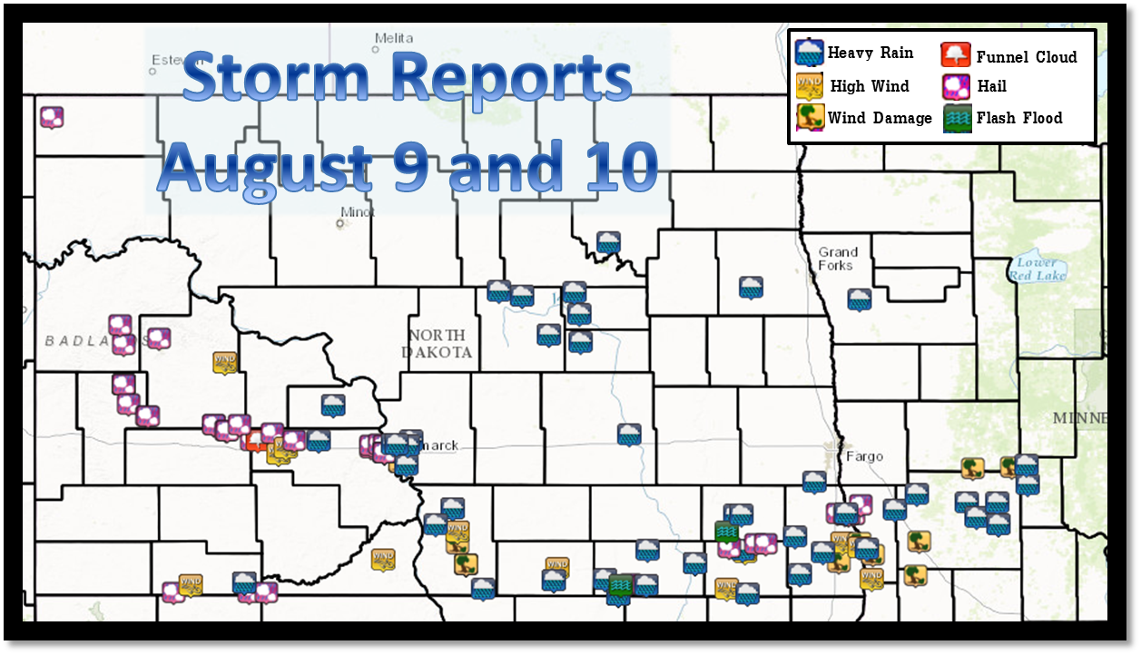 |
August 9th
Preliminary Storm Reports August 9, 2016

...Wind Reports...

Location                     Speed     Time/Date
5 N North Lemmon             81 MPH    1040 PM 08/09
8 N Selfridge                79 MPH    1150 PM 08/09
Hettinger                    76 MPH    0958 PM 08/09
Hettinger                    60 MPH    0954 PM 08/09
Bismarck, Nd                 54 MPH    1117 PM 08/09

...Hail Reports...

Location                     Size      Time/Date
5 N North Lemmon             1.75 in   1030 PM 08/09
10 E North Lemmon            1.50 in   1042 PM 08/09
3 ENE North Lemmon           1.00 in   1002 PM 08/09
7 S Bucyrus                  1.00 in   0941 PM 08/09

Observations are collected from a variety of sources with varying
equipment and exposures. Not all data listed are considered official.
August 10th:
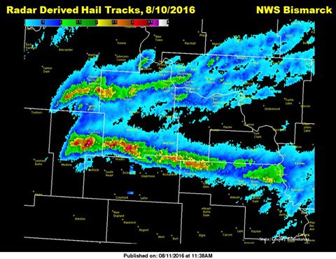 |
Preliminary Storm Reports from August 10, 2016

...Wind Reports...

Location                     Speed     Time/Date
2 SSE Temvik                 80 MPH    1226 AM 08/10
4 NE Glen Ullin              75 MPH    0835 PM 08/10
Strasburg                    70 MPH    1220 AM 08/10
2 N Halliday                 67 MPH    0735 PM 08/10
1 WNW Glen Ullin             67 MPH    0830 PM 08/10
Hazelton                     60 MPH    1215 AM 08/10
6 NNE Ashley                 60 MPH    0115 AM 08/10

...Rainfall Reports...

Location                     Amount    Time/Date
5 NE Monango                 5.75 in   1239 PM 08/10
6 NE Bismarck                4.50 in   0930 PM 08/10
8 NW Menoken                 4.00 in   1015 PM 08/10
Forbes                       4.00 in   0653 AM 08/10
Oakes                        4.00 in   0655 AM 08/10
9 NW Forbes                  3.52 in   1100 AM 08/10
3 S Hague                    3.00 in   0810 AM 08/10
3 NNE Mandan                 2.77 in   0945 PM 08/10
2 NNE Jamestown              2.68 in   0757 AM 08/10
5 N North Lemmon             2.40 in   0900 AM 08/10
Ellendale                    2.25 in   0524 AM 08/10
Ashley                       1.70 in   0750 AM 08/10
Ashley                       1.61 in   0900 AM 08/10
Heimdal                      1.58 in   1030 PM 08/10
8 E Cannon Ball              1.55 in   0740 AM 08/10
Hazelton                     1.50 in   0700 AM 08/10
3 W Center                   1.25 in   0900 AM 08/10
3 SSE Selz                   1.13 in   1030 PM 08/10
Mandan                       1.00 in   0955 PM 08/10

...Hail Reports...

Location                     Size      Time/Date
5 N Richardton               3.00 in   0755 PM 08/10
8 NE Glen Ullin              3.00 in   0846 PM 08/10
7 N Taylor                   2.75 in   0736 PM 08/10
8 WNW New Hradec             2.50 in   0726 PM 08/10
7 ENE Hebron                 2.50 in   0822 PM 08/10
4 E Crown Butte Lake         2.50 in   0942 PM 08/10
3 N Mandan                   2.00 in   0951 PM 08/10
Mandan                       2.00 in   0955 PM 08/10
4 E Crown Butte Lake         1.75 in   0940 PM 08/10
4 NNW Mandan                 1.75 in   0951 PM 08/10
Ellendale                    1.50 in   0100 PM 08/10
South Fairfield              1.50 in   0610 PM 08/10
7 NE Forbes                  1.00 in   1240 PM 08/10
5 NW Oakdale                 1.00 in   0608 PM 08/10
2 W Hebron                   1.00 in   0807 PM 08/10
10 NE Richardton             1.00 in   0815 PM 08/10
5 NW New Salem               1.00 in   0905 PM 08/10
1 W Ellendale                0.88 in   1254 PM 08/10
13 S Watford City            0.88 in   0525 PM 08/10
4 NNW Fairfield              0.75 in   0528 PM 08/10
Alkabo                       0.75 in   1150 PM 08/10

Observations are collected from a variety of sources with varying
equipment and exposures. Not all data listed are considered official.
 |
Media use of NWS Web News Stories is encouraged! Please acknowledge the NWS as the source of any news information accessed from this site. |
|

