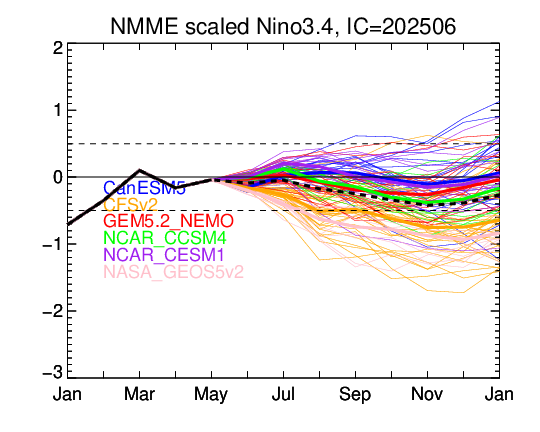
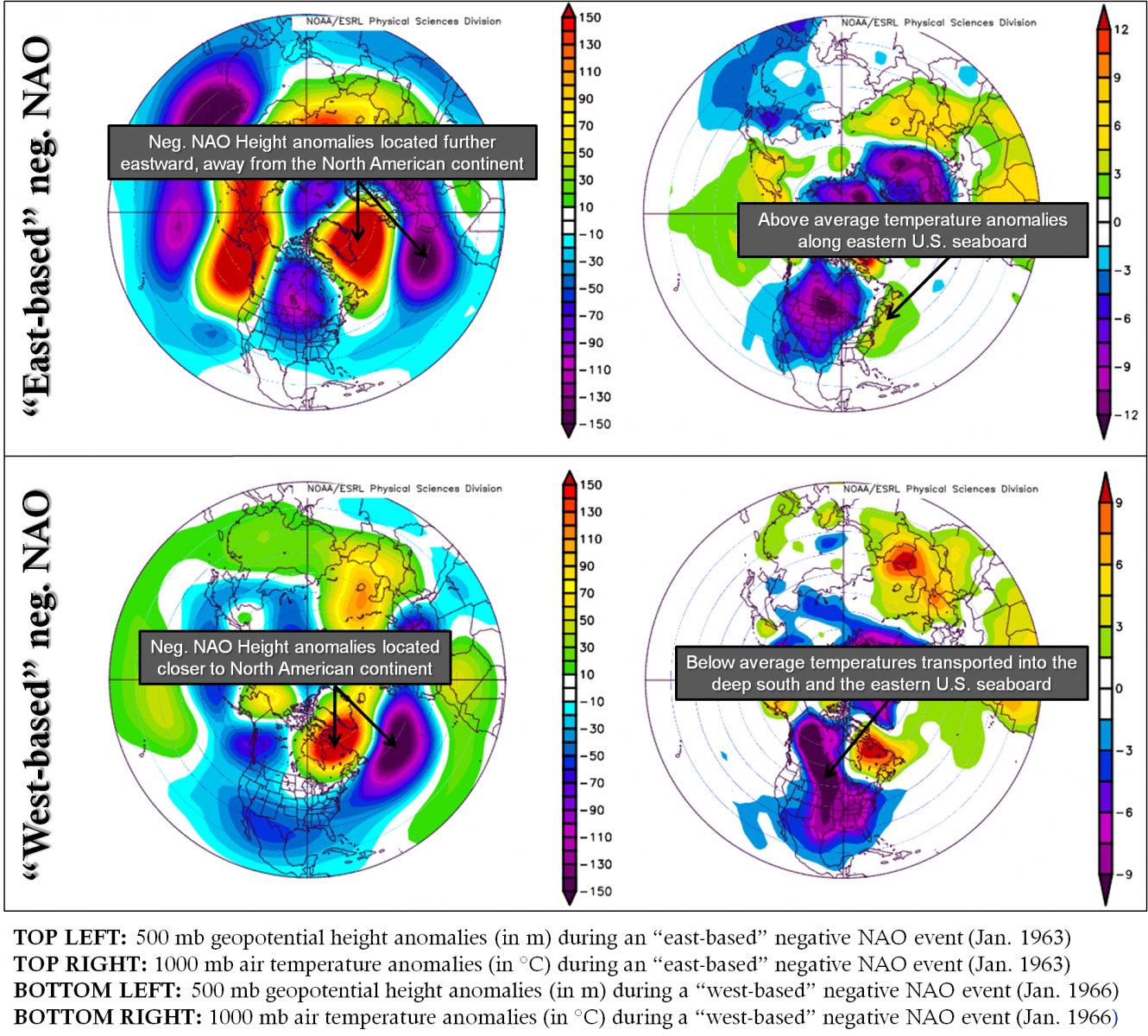
National Weather Service United States Department of Commerce


WFO BIS SA Display-Teleconnections
Navigation Menu
Climate

Weather

Hydro

DSS

Quick Jumps:
ENSO
 
MJO
 
AO
 
Stratospheric Warming
 
NAO
 
PNA
 
EP-NP
 
Blocking


El Nino Southern Oscillation (ENSO)
Composite Precipitation and Temperature Impacts
Latest ENSO Observations
Daily SST Anomaly
Weekly SST Anomaly
Monthly SST Anomaly 
Seasonal SST Anomaly 
Observed Regions
OLR Anomalies
850 mb Wind Anomalies
200 mb Wind Anomalies


Equitorial T Anomaly
Equitorial Temperature
20 C Depth Anomaly


Latest ENSO Forecasts
NMME Nino 3.4 Mean Forecasts
NMME Nino 3.4 All Forecasts
CPC CFSv2 Nino 3.4 
NMME/IMME Nino 3.4 Forecast


CFSv2 SST Seasonal Lead 1
CFSv2 SST Seasonal Lead 2
CFSv2 SST Seasonal Lead 3
CFSv2 SST Seasonal Lead 4


Quick Jumps:
ENSO
 
MJO
 
AO
 
Stratospheric Warming
 
NAO
 
PNA
 
EP-NP
 
Blocking


Madden-Julian Oscillation (MJO)
MJO Temperature Impact Composites By Phase
MJO Precipitation Impact Composites By Phase
GEFS Phase Diagram
High Res GFS Phase Diagram
Statistical Phase Diagram


OLR Anomalies
OLR Anomalies
200mb Velocity Potential


Quick Jumps:
ENSO
 
MJO
 
AO
 
Stratospheric Warming
 
NAO
 
PNA
 
EP-NP
 
Blocking


Arctic Oscillation (AO)
Composite Precipitation and Temperature Impacts
Observed/Forecast AO
Polar Vortex Cross Section

The Arctic Oscillation (AO) is compares 1000 mb height anomalies pole of 20N to those across the middle latitudes.

  • A positive AO suggests a stronger polar vortex with lower pressures near the pole, allowing the middle latitude jet stream to blow strongly and consistently from west to east, keeping colder air locked in the polar region.
  • A negative AO suggests higher pressures in the polar region, weaker zonal winds and the potential for acrtic air to move south into the middle latitudes. (1998 David WJ Thompson and John Michael Wallace)


Positive AO 500mb Anomalies
Negative AO 500mb Anomalies


Quick Jumps:
ENSO
 
MJO
 
AO
 
Stratospheric Warming
 
NAO
 
PNA
 
EP-NP
 
Blocking


Stratospheric Warming
Cumulative SSW Probability (GEFS-based) **CLICK HERE**


Zonal Temperature Anomalies (2022)
Zonal Temperature Anomalies (2023)


Zonal Wind Anomalies (2022)
Zonal Wind Anomalies (2023)


10mb Zonal Temperature Analysis
The values for the current year (bold red line) , the GEFS forecast for the next 16 days (green), and the extreme maximum and minimum values for the entire temperature analysis record from 1979 through the most recent complete calendar year, (bounding upper and lower black lines).


/*
GEFS 10hPa Ensemble Plume
This plot shows the 31-member extended GEFS zonal mean zonal wind from the latest available run. Members with winds below 0 m/s indicate either a major sudden stratospheric warming (SSW) or the final stratospheric warming. Other style of similar chart is available here.
*/


GFS 10 MB T Forecasts
H24
H48
H72
H96
H120
H144
H168
H192
H216
H240


GFS 30 MB Height Forecasts
H00
H24
H48
H72
H96
H120
H144
H168
H192
H216
H240


Quick Jumps:
ENSO
 
MJO
 
AO
 
Stratospheric Warming
 
NAO
 
PNA
 
EP-NP
 
Blocking


North American Oscillation (NAO)
NAO Observations and Forecasts
Forecast 700mb Anomalies
Obs. NH 500mb Anomalies

The positive phase of the NAO reflects below-normal heights and pressure across the high latitudes of the North Atlantic and above-normal heights and pressure over the central North Atlantic, the eastern United States and western Europe. The negative phase reflects an opposite pattern of height and pressure anomalies over these regions.

Strong positive phases of the NAO tend to be associated with above-average temperatures in the eastern United States and across northern Europe and below-average temperatures in Greenland and oftentimes across southern Europe and the Middle East. They are also associated with above-average precipitation over northern Europe and Scandinavia in winter, and below-average precipitation over southern and central Europe.


Positive NAO 500mb Anomalies
Positive NAO T Anomalies
Negative NAO 500mb Anomalies
Negative NAO T Anomalies
NAO Positional Impacts


Quick Jumps:
ENSO
 
MJO
 
AO
 
Stratospheric Warming
 
NAO
 
PNA
 
EP-NP
 
Blocking


Pacific North American Oscillation (PNA)
PNA Observations and Forecasts
Forecast 200mb Anomalies
Obs. NH 200mb Anomalies

The positive phase of the PNA pattern features above-average heights in the vicinity of Hawaii and over the intermountain region of North America, and below-average heights located south of the Aleutian Islands and over the southeastern United States. The PNA pattern is associated with strong fluctuations in the strength and location of the East Asian jet stream. 

The positive phase of the PNA pattern is associated with above-average temperatures over western Canada and the extreme western United States, and below-average temperatures across the south-central and southeastern U.S. The associated precipitation anomalies include above-average totals in the Gulf of Alaska extending into the Pacific Northwestern United States, and below-average totals over the upper Midwestern United States.


Positive PNA 500mb Anomalies
Positive PNA T Anomalies
Negative PNA 500mb Anomalies
Negative PNA T Anomalies


Quick Jumps:
ENSO
 
MJO
 
AO
 
Stratospheric Warming
 
NAO
 
PNA
 
EP-NP
 
Blocking


East Pacific-North Pacific Oscillation (EP-NP)
EP-NP Index
 

The East Pacific - North Pacific (EP- NP) pattern is a Spring-Summer-Fall pattern with three main anomaly centers. The positive phase of this pattern features positive height anomalies located over Alaska/ Western Canada, and negative anomalies over the central North Pacific and eastern North America. Strong positive phases of the EP-NP pattern are associated with a southward shift and intensification of the Pacific jet stream from eastern Asia to the eastern North Pacific, followed downstream by an enhanced anticyclonic circulation over western North America, and by an enhanced cyclonic circulation over the eastern United States. Strong negative phases of the pattern are associated with circulation anomalies of opposite sign in these regions.

The positive phase of the EP-NP pattern is associated with above-average surface temperatures over the eastern North Pacific, and below-average temperatures over the central North Pacific and eastern North America. The main precipitation anomalies associated with this pattern reflect above-average precipitation in the area north of Hawaii and below-average precipitation over southwestern Canada.

Bell and Janowiak (1995, Bull. Amer. Meteor. Soc.) noted that the atmospheric circulation during the several months prior to the onset of the Midwest floods of June-July 1993 was dominated by a very strong positive phase of the EP-NP pattern. Their study concluded these conditions were indirectly important to the onset and overall magnitude of the floods, since they fostered an anomalously intense storm track over the midlatitudes of the North Pacific. Dramatic changes in this storm track during June then ultimately initiated the Midwest floods.


Quick Jumps:
ENSO
 
MJO
 
AO
 
Stratospheric Warming
 
NAO
 
PNA
 
EP-NP
 
Blocking


Atmospheric Blocking
Blocking Index Explanation
Blocking Strength (GHGS Blocking Index)
500mb Heights and Anomalies


Quick Jumps:
ENSO
 
MJO
 
AO
 
Stratospheric Warming
 
NAO
 
PNA
 
EP-NP
 
Blocking