Dangerous heat will expand from the Gulf Coast into the Southern Plains and Desert Southwest through week's end. Additional extreme heat impacting the Pacific Northwest will shift to the northern Plains by the weekend. Tropical Storm Bertha is expected to continue to impact portions of the northern Gulf Coast from the western Florida Panhandle to southeastern Louisiana through tonight. Read More >
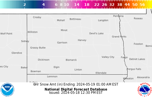
This page will be around all winter and we constantly update it.BOOKMARK IT! for all your winter weather needs.
|


 Blizzard Warning
 Winter Storm Warning
 Winter Weather Advisory
 Ice Storm Warning
 Freezing Rain Advisory
 Wind Chill Warning
 Blizzard Watch
 Winter Storm Watch
 Special Weather Statement
 High Wind Watch
 High Wind Warning