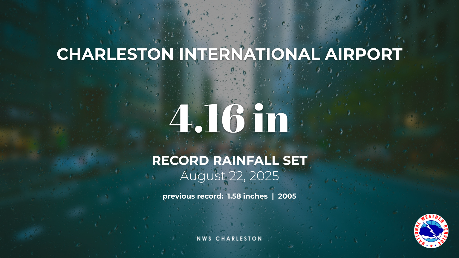
Overview
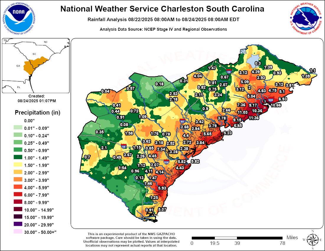
Between August 22-23, 2025, numerous to widespread showers and thunderstorms produced heavy rainfall across the South Carolina Lowcountry and southeast Georgia as a cold front stalled over the region. This boundary caused widespread flash flooding, which was intensified by soils already saturated from heavy rain earlier in the month. Flooding along the coast was exacerbated by high tide, with the Charleston Harbor Tide Gage reporting periods of moderate coastal flooding. The event led to numerous road closures, inundated vehicles, and flooded structures, and also set new rainfall records — including at two of our climate sites, as shown in the images below.
|
|
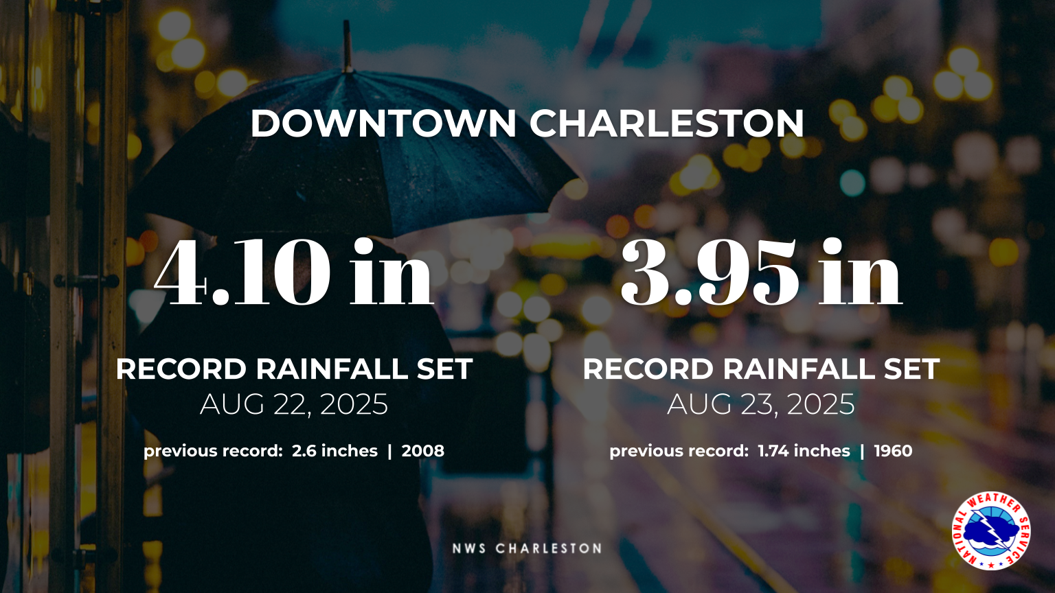 Downtown Charleston Rainfall Records Downtown Charleston Rainfall Records |
Rain Reports
|
|
NZUS92 KCHS 241636 LLLCHS GAZ087-088-099>101-114>119-137>141-SCZ040-042>045-047>052-250436- Public Information Statement National Weather Service Charleston SC 1236 PM EDT Sun Aug 24 2025 ...PRECIPITATION REPORTS... Location Amount Time/Date Lat/Lon Mount Pleasant 1.6 S 12.10 in 0800 AM 08/24 32.80N/79.87W Mount Pleasant 1.6 SSE 11.88 in 0600 AM 08/24 32.80N/79.85W Charleston 5.2 ESE 11.84 in 0725 AM 08/24 32.74N/79.92W Mount Pleasant 1.8 SW 11.52 in 0700 AM 08/24 32.80N/79.88W Charleston 2.8 NE 11.41 in 0700 AM 08/24 32.81N/79.96W Kiawah Island 3.9 W 11.36 in 0700 AM 08/24 32.63N/80.13W Wadmalaw Island 3.6 ENE 11.03 in 0700 AM 08/24 32.68N/80.12W Mount Pleasant 2.7 S 10.66 in 0900 AM 08/24 32.78N/79.86W Charleston 5.4 SSE 10.58 in 0600 AM 08/24 32.72N/79.95W Johns Island 3.3 WNW 10.36 in 0700 AM 08/24 32.71N/80.09W Mount Pleasant 0.4 E 10.21 in 0545 AM 08/24 32.82N/79.86W Mount Pleasant 1.3 WSW 9.78 in 0702 AM 08/24 32.82N/79.89W Charleston 2.3 NE 9.76 in 0658 AM 08/24 32.80N/79.96W Johns Island 1.8 NE 9.17 in 0650 AM 08/24 32.72N/80.01W 1 SE Edisto Island 9.15 in 0700 AM 08/24 32.54N/80.26W Mount Pleasant 2.2 W 9.11 in 0700 AM 08/24 32.82N/79.90W Charleston 1.7 SE 9.00 in 0800 AM 08/24 32.76N/79.98W Charleston 3.5 SSE 8.99 in 0900 AM 08/24 32.74N/79.97W Hollywood 4.3 SE 8.89 in 0700 AM 08/24 32.71N/80.14W 1 E Johns Island 8.85 in 0700 AM 08/24 32.72N/80.04W Seabrook Island 0.2 S 8.71 in 0700 AM 08/24 32.58N/80.18W Wadmalaw Island 4.1 NE 8.67 in 0800 AM 08/24 32.70N/80.12W Charleston 4.6 SSE 8.43 in 0800 AM 08/24 32.73N/79.96W Charleston 3.0 N 8.06 in 0900 AM 08/24 32.83N/79.99W Charleston 0.3 ESE 8.05 in 0700 AM 08/24 32.78N/79.99W Charleston 1.6 SSW 7.58 in 0800 AM 08/24 32.76N/80.00W Johns Island 5.0 W 7.36 in 0800 AM 08/24 32.73N/80.15W Wadmalaw Island 2.3 SSW 7.16 in 0800 AM 08/24 32.63N/80.20W Edisto Beach 5.1 NNW 6.98 in 0807 AM 08/24 32.56N/80.34W Isle Of Palms 0.1 E 6.93 in 0800 AM 08/24 32.80N/79.76W Mount Pleasant 4.1 NE 6.65 in 0700 AM 08/24 32.86N/79.81W Mount Pleasant 1.9 N 6.54 in 0723 AM 08/24 32.85N/79.86W Edisto Beach 2.7 N 6.45 in 0700 AM 08/24 32.53N/80.31W Charleston 4.8 WNW 6.07 in 0700 AM 08/24 32.81N/80.07W Midway 12.6 SE 5.93 in 0710 AM 08/24 31.69N/81.26W Charleston 5.0 WNW 5.87 in 0700 AM 08/24 32.81N/80.07W Tybee Island 1.1 NNE 5.82 in 0800 AM 08/24 32.02N/80.85W Savannah 10.4 E 5.82 in 0800 AM 08/24 32.02N/80.95W Beaufort 1.6 SSW 5.65 in 0600 AM 08/24 32.41N/80.70W Mount Pleasant 7.0 NE 5.39 in 0800 AM 08/24 32.90N/79.79W North Charleston 3.5 ESE 5.31 in 0735 AM 08/24 32.88N/79.99W Mount Pleasant 7.5 NE 5.25 in 0700 AM 08/24 32.89N/79.77W Saint Helena 7.0 E 5.23 in 0700 AM 08/24 32.38N/80.44W Charleston Intl Airport 5.12 in 1156 AM 08/24 32.90N/80.03W Mount Pleasant 8.2 NE 5.10 in 0700 AM 08/24 32.90N/79.75W Charleston 9.1 NE 5.09 in 0700 AM 08/24 32.89N/79.89W Summerville 2.7 WNW 5.09 in 0744 AM 08/24 33.01N/80.22W Sapelo Island 2.3 NW 5.07 in 0800 AM 08/24 31.43N/81.26W NWS Charleston SC 5.04 in 0700 AM 08/24 32.89N/80.03W Folly Beach 5.03 in 0750 AM 08/24 32.65N/79.95W Mount Pleasant 4.6 NNE 4.99 in 0730 AM 08/24 32.88N/79.83W Summerville 2.1 WSW 4.99 in 0730 AM 08/24 33.00N/80.21W Mount Pleasant 8.5 NE 4.90 in 0700 AM 08/24 32.91N/79.76W Mount Pleasant 5.6 ENE 4.89 in 0800 AM 08/24 32.86N/79.77W Mount Pleasant 6.5 NNE 4.75 in 0700 AM 08/24 32.91N/79.81W Mount Pleasant 1.9 ESE 4.68 in 0830 AM 08/24 32.81N/79.83W Summerville 3.2 WNW 4.64 in 0850 AM 08/24 33.03N/80.23W Charleston 10.0 NE 4.63 in 0800 AM 08/24 32.90N/79.89W Pooler 1.2 NNE 4.45 in 0700 AM 08/24 32.12N/81.25W Skidaway Island 0.8 NE 4.43 in 0700 AM 08/24 31.94N/81.04W Ridgeland 9.9 SSE 4.40 in 0800 AM 08/24 32.34N/80.94W Summerville 5.8 NE 4.37 in 0700 AM 08/24 33.06N/80.10W Charleston 3.8 NW 4.30 in 0800 AM 08/24 32.82N/80.05W Moncks Corner 6.6 SW 4.29 in 0700 AM 08/24 33.14N/80.09W Richmond Hill 7.0 ESE 4.14 in 0800 AM 08/24 31.89N/81.20W Richmond Hill 0.5 NE 4.11 in 0700 AM 08/24 31.95N/81.30W Summerville 8.9 NNE 4.10 in 0800 AM 08/24 33.12N/80.10W Smoaks 0.1 ESE 4.04 in 0800 AM 08/24 33.09N/80.81W Beaufort 3.6 SW 4.03 in 0800 AM 08/24 32.39N/80.74W North Charleston 4.0 SSE 4.02 in 0700 AM 08/24 32.85N/80.03W Coffee Bluff 3.98 in 0700 AM 08/24 31.94N/81.16W Burnside 3.98 in 0700 AM 08/24 31.94N/81.10W Summerville 5.8 NNE 3.95 in 0600 AM 08/24 33.08N/80.15W Moncks Corner 5.1 SSW 3.93 in 0700 AM 08/24 33.13N/80.03W Savannah 5.9 SSW 3.92 in 0700 AM 08/24 31.94N/81.16W Hilton Head Island 4.0 N 3.84 in 0700 AM 08/24 32.25N/80.73W Charleston 4.0 NW 3.84 in 0700 AM 08/24 32.83N/80.03W Wambaw 3.81 in 1147 AM 08/24 32.97N/79.67W Beaufort 4.5 NE 3.79 in 0630 AM 08/24 32.47N/80.63W Bennetts Point 3.78 in 1145 AM 08/24 32.56N/80.45W North Charleston 3.1 E 3.77 in 0730 AM 08/24 32.90N/79.99W Pembroke 3.67 in 1204 PM 08/24 32.10N/81.63W Marlow 0.0 S 3.62 in 0800 AM 08/24 32.27N/81.39W North Charleston 4.4 W 3.61 in 0800 AM 08/24 32.91N/80.12W Beaufort 6.5 NNW 3.42 in 0800 AM 08/24 32.51N/80.73W Savannah NWR 3.28 in 1123 AM 08/24 32.17N/81.12W Beaufort 4.2 WSW 3.26 in 0800 AM 08/24 32.41N/80.76W Okatie 7.6 NE 3.25 in 0700 AM 08/24 32.37N/80.85W Cottageville 5.8 WSW 3.24 in 0700 AM 08/24 32.89N/80.57W Savannah 2.3 SSW 3.20 in 0700 AM 08/24 31.99N/81.14W Rincon 4 SE 3.18 in 1145 AM 08/24 32.26N/81.18W Summerville 9.3 NNE 3.12 in 0700 AM 08/24 33.13N/80.13W Huger 7.7 S 3.12 in 0800 AM 08/24 32.98N/79.80W Summerville 1.7 SSE 3.12 in 0900 AM 08/24 32.98N/80.17W Beaufort 2.7 E 3.10 in 0700 AM 08/24 32.43N/80.64W North Charleston 3.7 NNW 3.07 in 0800 AM 08/24 32.96N/80.06W Beaufort 7.1 WNW 2.94 in 0800 AM 08/24 32.47N/80.80W Hilton Head Island 4.4 NNE 2.91 in 0800 AM 08/24 32.26N/80.73W Bluffton 0.7 NNW 2.90 in 0800 AM 08/24 32.24N/80.87W Beaufort MCAS 2.89 in 1156 AM 08/24 32.47N/80.72W Bluffton 6.4 NW 2.72 in 0800 AM 08/24 32.29N/80.95W Savannah Intl Airport 2.70 in 1153 AM 08/24 32.12N/81.20W Bluffton 7.7 WNW 2.68 in 0700 AM 08/24 32.27N/80.99W Ridgeland 5.8 ESE 2.68 in 0555 AM 08/24 32.45N/80.89W Bluffton 6.3 WNW 2.67 in 0700 AM 08/24 32.27N/80.96W Meggett 1.8 W 2.67 in 0630 AM 08/24 32.70N/80.29W Ace Basin 2.66 in 1200 PM 08/24 32.66N/80.40W Beaufort 0.8 NE 2.64 in 0700 AM 08/24 32.44N/80.68W Limehouse 2.59 in 1130 AM 08/24 32.19N/81.12W Hampton 0.2 SW 2.53 in 0700 AM 08/24 32.87N/81.11W Abercorn Creek 2.52 in 1200 PM 08/24 32.25N/81.15W Ridgeland 6.4 ESE 2.49 in 0718 AM 08/24 32.44N/80.88W Limehouse 4 SW 2.45 in 1145 AM 08/24 32.17N/81.12W Moncks Corner 1.0 NNW 2.42 in 0700 AM 08/24 33.21N/80.01W Bluffton 7.4 W 2.38 in 0800 AM 08/24 32.22N/80.99W Port Wentworth 6 N 2.34 in 1145 AM 08/24 32.24N/81.15W Savannah 4.7 ESE 2.30 in 0700 AM 08/24 32.00N/81.06W Garden City 1.2 NNE 2.28 in 0746 AM 08/24 32.12N/81.15W Morgans Tower 2.26 in 1219 PM 08/24 32.09N/81.40W Beaufort 5.7 NE 2.25 in 0900 AM 08/24 32.49N/80.63W 1 W Walling Grove 2.23 in 0700 AM 08/24 32.49N/80.68W Hampton 0.8 SW 2.18 in 0700 AM 08/24 32.86N/81.12W Savannah 3.4 SSE 2.17 in 0800 AM 08/24 31.98N/81.11W Walterboro 1 SW 2.11 in 0700 AM 08/24 32.88N/80.68W Bellville 2.8 N 2.10 in 0700 AM 08/24 32.19N/81.97W Summerville 5.7 SSE 2.08 in 0700 AM 08/24 32.93N/80.13W Richmond Hill 3 NE 2.07 in 1200 PM 08/24 31.98N/81.29W Cottageville 3.1 NNW 2.07 in 0830 AM 08/24 32.98N/80.49W Hunter Army Air Field 2.04 in 1155 AM 08/24 32.02N/81.15W Summerville 2.6 E 2.00 in 0700 AM 08/24 33.00N/80.13W Midway 3.8 NE 1.96 in 0800 AM 08/24 31.83N/81.37W Ellabell 7 SE 1.95 in 1200 PM 08/24 32.08N/81.39W Charleston 5.6 SE 1.85 in 0700 AM 08/24 32.73N/79.92W Walterboro 7.4 NNE 1.81 in 0700 AM 08/24 33.00N/80.63W Springfield 2.4 E 1.76 in 0700 AM 08/24 32.37N/81.27W Mount Pleasant 1.7 NNW 1.75 in 0700 AM 08/24 32.85N/79.87W Blitchton 4 WSW 1.71 in 1100 AM 08/24 32.17N/81.49W Port Wentworth 1 NE 1.64 in 1130 AM 08/24 32.17N/81.15W Brooklet 1 W 1.58 in 0600 AM 08/24 32.38N/81.67W Taylors Creek 1.54 in 1204 PM 08/24 31.94N/81.75W Blitchton 4 WSW 1.52 in 1115 AM 08/24 32.17N/81.49W Midway 3.3 ENE 1.47 in 0700 AM 08/24 31.82N/81.37W Reevesville 1.0 SSE 1.47 in 0700 AM 08/24 33.19N/80.64W Midway 1.46 in 1204 PM 08/24 31.78N/81.44W McClellanville 0.5 ESE 1.42 in 0700 AM 08/24 33.08N/79.46W Moncks Corner 3.6 E 1.39 in 0700 AM 08/24 33.20N/79.94W Mcclellanville 0.2 ESE 1.39 in 0630 AM 08/24 33.08N/79.46W Townsend 5.5 SE 1.25 in 0700 AM 08/24 31.57N/81.36W Port Wentworth 2 ESE 1.16 in 1200 PM 08/24 32.14N/81.14W Ellabell 5.0 NNW 1.15 in 1100 AM 08/24 32.19N/81.51W Richmond Hill 9 WNW 1.12 in 1130 AM 08/24 31.97N/81.46W McClellanville 7.6 NE 1.10 in 0710 AM 08/24 33.15N/79.36W Newington 0.5 SSE 1.09 in 0700 AM 08/24 32.58N/81.50W Ellabell 7 SE 0.99 in 1115 AM 08/24 32.08N/81.39W Lawson 0.96 in 1204 PM 08/24 31.90N/81.59W Witherbee 0.93 in 1213 PM 08/24 33.16N/79.83W Rocky Ford 4 SE 0.91 in 0728 AM 08/24 32.63N/81.78W Sapelo Island 0.91 in 1200 PM 08/24 31.42N/81.29W Combahee 0.90 in 1149 AM 08/24 32.68N/80.71W Eden 0.85 in 1115 AM 08/24 32.19N/81.42W Walterboro 3.0 NNW 0.82 in 0700 AM 08/24 32.94N/80.68W Rincon 5.3 NNE 0.78 in 0800 AM 08/24 32.36N/81.21W Walterboro 0.75 in 1207 PM 08/24 32.92N/80.63W Sylvania Airport 0.72 in 1115 AM 08/24 32.65N/81.60W Reidsville 0.70 in 1200 PM 08/24 32.08N/82.18W Ridgeville 3.2 WSW 0.67 in 0600 AM 08/24 33.08N/80.36W Charleston 2.9 NNE 0.66 in 0700 AM 08/24 32.83N/79.98W Hilltonia 4 N 0.57 in 1200 PM 08/24 32.93N/81.65W Glissons Pond 0.49 in 1204 PM 08/24 32.07N/81.82W Rocky Ford 0.44 in 1200 PM 08/24 32.65N/81.84W Richmond Hill 0.42 in 1204 PM 08/24 31.98N/81.38W Rocky Ford 4.2 N 0.41 in 0700 AM 08/24 32.72N/81.83W Metter 0.35 in 1203 PM 08/24 32.39N/82.04W Lodge 3.4 SW 0.31 in 0700 AM 08/24 33.03N/80.99W Moncks Corner 4 N 0.30 in 0600 AM 08/24 33.24N/79.99W Hutchinson Island 0.29 in 1115 AM 08/24 32.08N/81.08W Summerville 5.0 WSW 0.24 in 0700 AM 08/24 32.99N/80.26W SANTEE COAST MCCLELLANVILLE 0.24 in 1000 AM 08/24 33.15N/79.36W Allendale 1.7 SE 0.18 in 0600 AM 08/24 32.99N/81.29W McIntosh 0.13 in 1215 PM 08/24 31.82N/81.54W Statesboro Airport 0.08 in 1215 PM 08/24 32.48N/81.73W Elba Island 0.07 in 1130 AM 08/24 32.10N/81.01W Beaufort 0.5 N 0.06 in 0746 AM 08/24 32.43N/80.69W Millen Airport 0.04 in 1215 PM 08/24 32.90N/81.97W && |
Flooding
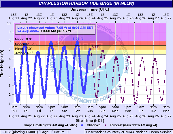
Moderate to heavy rainfall coupled with saturated soils resulted in widespread flooding across our area on August 22-23, 2025. Some of the more notable impacts occurred along the coast, where high tides resulted in periods of moderate coastal flooding, as seen in the Charleston Harbor Tide Gage image below. Periods of minor coastal flooding were also noted on the Fort Pulaski Tide Gage.
Hydrographs
 |
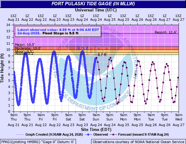 |
| Charleston Harbor Tide Gage (in MLLW) | Fort Pulaski Tide Gage (in MLLW) |
Storm Reports
NWUS52 KCHS 231301
LSRCHS

Preliminary Local Storm Report...Summary
National Weather Service Charleston SC
901 AM EDT Sat Aug 23 2025

..TIME...   ...EVENT...      ...CITY LOCATION...     ...LAT.LON...
..DATE...   ....MAG....      ..COUNTY LOCATION..ST.. ...SOURCE....
            ..REMARKS..

1147 AM     Flash Flood      1 SSE Charleston Airpor 32.88N  80.03W
08/22/2025                   Charleston         SC   Public

            Public reports International Blvd heading into the
            Charleston International Airport in front of the
            terminals is flooded and impassable.

1210 PM     Flash Flood      2 NW North Charleston   32.88N  80.00W
08/22/2025                   Charleston         SC   Law Enforcement

            North Charleston PD reports Montague at Morningside is
            impassable due to flooding.

1219 PM     Flash Flood      Charleston              32.78N  79.94W
08/22/2025                   Charleston         SC   Law Enforcement

            Charleston PD reports intersection of Calhoun St and
            Ogier St is closed due to flash flooding.

1220 PM     Flash Flood      1 WNW Charleston        32.79N  79.96W
08/22/2025                   Charleston         SC   Law Enforcement

            Charleston PD reports Hagood Ave and Fishburne St
            intersection is closed due to flash flooding.

1225 PM     Flash Flood      North Charleston        32.85N  79.98W
08/22/2025                   Charleston         SC   Law Enforcement

            North Charleston PD reports Dorchester Road at Meetings
            St is closed due to flash flooding.

1225 PM     Flash Flood      1 SSE Hanahan           32.90N  80.02W
08/22/2025                   Charleston         SC   Law Enforcement

            North Charleston PD reports numerous road closures on
            Rivers Ave from the 5300-5900 blocks

1225 PM     Flash Flood      2 N North Charleston    32.88N  79.98W
08/22/2025                   Charleston         SC   Law Enforcement

            North Charleston PD reports Buist Ave and Spruill Ave
            intersection is closed due to flash flooding.

1226 PM     Flash Flood      1 NNW Charleston        32.80N  79.95W
08/22/2025                   Charleston         SC   Law Enforcement

            Charleston PD reports Spruill Ave and Buist Ave
            intersection is closed due to flash flooding.

1230 PM     Flash Flood      1 ENE Charleston        32.79N  79.93W
08/22/2025                   Charleston         SC   Law Enforcement

            Charleston PD reporting large section of Washtington St
            is closed to due flash flooding at the intersection of
            Washington St and Society St.

1255 PM     Flash Flood      1 SSW Charleston        32.78N  79.94W
08/22/2025                   Charleston         SC   Law Enforcement

            Charleston PD report Broad street closed between Ashley
            Ave and Rutledge Ave due to flash flooding.

1256 PM     Rain             2 NNW Charleston        32.81N  79.96W
08/22/2025  M2.48 inch       Charleston         SC   CoCoRaHS

            CoCoRHAS observer SC-CR-42 reported 2.48 inches in 1
            hour.

0100 PM     Flash Flood      1 SSW Mount Pleasant    32.78N  79.87W
08/22/2025                   Charleston         SC   Emergency Mngr

            EM reports flash flooding on Middle St near Alhambra
            Hall

0105 PM     Flash Flood      3 N Mount Pleasant      32.84N  79.86W
08/22/2025                   Charleston         SC   Emergency Mngr

            EM reports flash flooding on Long Point Road near Belle
            Point Dr.

0106 PM     Flash Flood      1 N Mount Pleasant      32.81N  79.86W
08/22/2025                   Charleston         SC   Emergency Mngr

            EM reports flash flooding at the intersection of Anna
            Knapp and Johnnie Dodds blvd.

0149 PM     Rain             1 SE Charleston         32.78N  79.93W
08/22/2025  M3.47 inch       Charleston         SC   Mesonet

            Mesonet site Charleston Fire #17 on Johns Island. 3
            hour rainfall total of 3.47 inches, with peak rainfall
            rate of 3.33 inches per hour at 12:40 PM. Rainfall is
            ongoing.

0155 PM     Flash Flood      Charleston              32.78N  79.94W
08/22/2025                   Charleston         SC   Public

            A member of the public reported water has entered
            businesses and the bottom floors of a few homes along
            Calhoun Street near Ogier Street.

0226 PM     Rain             3 NNW Kiawah Island     32.65N  80.10W
08/22/2025  M4.50 inch       Charleston         SC   Public

            Current daily rainfall total, rain is ongoing.

0226 PM     Rain             1 SE Charleston         32.78N  79.93W
08/22/2025  M2.54 inch       Charleston         SC   Mesonet

            Mesonet site Charleston Dock Street Theater. 3 hour
            rainfall total, with rain ongoing. Peak rainfall rate of
            2.4 inches per hour was observed at 114 PM.

0300 PM     Rain             7 SW Moncks Corner      33.14N  80.11W
08/22/2025  M3.17 inch       Berkeley           SC   Public

            3.17 inches of rainfall was reported to have fallen in
            three hours ending at 3 pm EDT on Rowley Lane in Cane
            Bay.

0322 PM     Flash Flood      1 NE Knightsville       33.02N  80.23W
08/22/2025                   Dorchester         SC   Emergency Mngr

            Dorchester County EMA reports Congressional Blvd at
            Butterfield road is flooded and not passable.

0327 PM     Flash Flood      1 ESE Jedburg           33.05N  80.23W
08/22/2025                   Dorchester         SC   Emergency Mngr

            Dorchester Fire Deppartment station 10 has flooding in
            the living quarters.

0327 PM     Flood            3 SSW Knightsville      32.98N  80.26W
08/22/2025                   Dorchester         SC   Emergency Mngr

            Six inches of water on the 200 block of Hundred Oaks
            Parkway in the Ponds neighborhood. Many other roads
            throughout that area are flooded and/or impassable.

0407 PM     Rain             2 SW Knightsville       32.99N  80.26W
08/22/2025  M4.68 inch       Dorchester         SC   NWS Employee

            Off duty NWS employee reported 4.68 inches of rainfall
            on Cherry Grove Drive,in the Ponds neighborhood so far
            today.

0428 PM     Flash Flood      1 E Knightsville        33.01N  80.22W
08/22/2025                   Dorchester         SC   Emergency Mngr

            Dorchester County EMA reports the 300 block of Woodward
            Blvd is flooded and impassable.

0445 PM     Flash Flood      5 SW Knightsville       32.95N  80.28W
08/22/2025                   Dorchester         SC   Emergency Mngr

            Roadways impassable around 1000 Anne Revenge Run,
            Summerville area. Water was also reported to be
            approaching the porches of some homes.

0447 PM     Flash Flood      7 NE College Park       33.10N  80.03W
08/22/2025                   Berkeley           SC   Emergency Mngr

            Berkeley County EMA reports Foxbank Planation Road
            closed and impassable at Trotter Lane due to flash
            flooding.

0447 PM     Flash Flood      6 NE College Park       33.09N  80.03W
08/22/2025                   Berkeley           SC   Emergency Mngr

            Berkeley County EMA reported Yorkshire Drive closed and
            impassable at Cypress Gardens Road due to flash
            flooding.

0454 PM     Rain             2 NNW Charleston        32.81N  79.96W
08/22/2025  M6.11 inch       Charleston         SC   Co-Op Observer

            CoCoRHAS observer SC-CR-42 reported 6.11 inches of rain
            since midnight with 3.63 inches over the past 4 hours.

0510 PM     Rain             3 NNW Kiawah Island     32.65N  80.11W
08/22/2025  M5.50 inch       Charleston         SC   Trained Spotter

            5.5 inches of rain has fallen so far today near the
            lower/southern end of River Road, near the St. Johns
            Fire Department Station 5.

0513 PM     Flood            Ruffin                  33.01N  80.82W
08/22/2025                   Colleton           SC   Emergency Mngr

            Tree down near the intersection of Quarters Drive and
            Brookie Street due to heavy rainfall.

0517 PM     Flash Flood      2 SE Knightsville       32.99N  80.22W
08/22/2025                   Dorchester         SC   Emergency Mngr

            Dorchester County EMA relayed images showing water has
            entered the bottom floors of several homes along Boon
            Hill Road.

0530 PM     Flash Flood      1 NW Charleston         32.79N  79.94W
08/22/2025                   Charleston         SC   Emergency Mngr

            A sink hole developed near the intersection of Cannon
            Street and Felix Street. The sink hole roughly measured
            two feet by two feet.

0600 PM     Rain             1 E Mount Pleasant      32.80N  79.84W
08/22/2025  M6.51 inch       Charleston         SC   NWS Employee

            A NOAA employee reported 6.51 inches of rain between
            midnight and 6 PM.

0615 PM     Flood            3 WNW Ridgeland         32.49N  81.02W
08/22/2025                   Jasper             SC   Law Enforcement

            Law enforcement reported that a portion of Nimmer Turf
            Road, close to the intersection of Tarboro Road, was
            flooded.

0631 PM     Flash Flood      3 NNE Bloomingdale      32.17N  81.27W
08/22/2025                   Chatham            GA   Emergency Mngr

            CEMA reports a car is flooded at Highlands Blvd and
            Morgan Lakes Industrial Blvd.

0637 PM     Flash Flood      4 NNW Bloomingdale      32.19N  81.32W
08/22/2025                   Effingham          GA   Emergency Mngr

            Emergency manager reports Windsor Road is flooded.
            Water is getting into two home garages. One car flooded.

0714 PM     Flash Flood      2 N Pooler              32.14N  81.25W
08/22/2025                   Chatham            GA   Emergency Mngr

            City of Savannah EMA reports Benton Blvd between
            Mulberry Road and Pooler Parkway is flooded and
            impassable.

0800 PM     Flash Flood      4 NW Belfast            31.86N  81.34W
08/22/2025                   Bryan              GA   911 Call Center

            Portion of Belfast Road washed out near I-95.

0817 PM     Rain             2 NW Charleston         32.80N  79.96W
08/22/2025  M4.90 inch       Charleston         SC   Public

            4.9 inches of rainfall so far today along Gordon Street
            in Charleston.

0830 PM     Coastal Flood    1 E Charleston          32.78N  79.93W
08/22/2025                   Charleston         SC   Other Federal

            CHTS1 Moderate Coastal Flooding: A maximum tide level
            of 7.93 ft MLLW (2.17 ft MHHW) was observed at the
            Charleston Harbor tide gage. Moderate coastal flooding
            typically begins along the coasts of Charleston and
            Colleton counties when tide levels reach 7.5 ft MLLW
            (1.74 FT MHHW) in the Charleston Harbor.

0854 PM     Coastal Flood    4 NW Tybee Island       32.04N  80.91W
08/22/2025                   Chatham            GA   Other Federal

            FPKG1 Minor Coastal Flooding: A maximum tide level of
            9.69 ft MLLW (2.19 ft MHHW) was observed at the Fort
            Pulaski tide gage located near the Savannah River
            Entrance. Shallow coastal flooding typically begins
            along much of the Georgia and far southern South
            Carolina coasts when tide levels reach 9.5 ft MLLW (2.0
            ft MHHW) at Fort Pulaski.
NWUS52 KCHS 240426
LSRCHS

Preliminary Local Storm Report...Summary
National Weather Service Charleston SC
1225 AM EDT Sun Aug 24 2025

..TIME...   ...EVENT...      ...CITY LOCATION...     ...LAT.LON...
..DATE...   ....MAG....      ..COUNTY LOCATION..ST.. ...SOURCE....
            ..REMARKS..

0756 AM     Flash Flood      1 N Charleston          32.80N  79.94W
08/23/2025                   Charleston         SC   Law Enforcement

            King St and Huger St closed due to high water.

0803 AM     Flash Flood      Charleston              32.78N  79.94W
08/23/2025                   Charleston         SC   Law Enforcement

            Ogier St and Calhoun St are closed due to flooding.

0825 AM     Flash Flood      1 WNW Charleston        32.79N  79.96W
08/23/2025                   Charleston         SC   Law Enforcement

            Hagood Avenue and Fishburne St closed due to high
            water.

0830 AM     Flood            1 NNE Ridgeland         32.50N  80.97W
08/23/2025                   Jasper             SC   Law Enforcement

            Highway 17 and I-95 at exit ramp 22 is currently
            flooded with around 2 ft of water on the road.

0830 AM     Flood            1 WSW Ridgeland         32.48N  80.99W
08/23/2025                   Jasper             SC   Law Enforcement

            Carters Mill Road is flooded due to Captain Bill Creek
            backing up.

0832 AM     Flash Flood      1 N Charleston          32.80N  79.94W
08/23/2025                   Charleston         SC   Law Enforcement

            North Nassau St and Romney St closed due to flooding.

0845 AM     Coastal Flood    Charleston              32.78N  79.94W
08/23/2025                   Charleston         SC   Law Enforcement

            Ashley Avenue at Calhoun St and Bull St is closed due
            to flooding. Closure happened near high tide wile
            raining.

0854 AM     Coastal Flood    1 E Charleston          32.78N  79.93W
08/23/2025                   Charleston         SC   Other Federal

            CHTS1 Minor Coastal Flooding: A maximum tide level of
            7.39 ft MLLW (1.63 ft MHHW) was observed at the
            Charleston Harbor tide gage. Shallow Coastal Flooding
            typically begins along the coasts of Charleston and
            Colleton counties when tide levels reach 7.0 ft MLLW
            (1.24 ft MHHW) in the Charleston Harbor.

0909 AM     Flash Flood      1 SSW Charleston        32.77N  79.94W
08/23/2025                   AMZ330             SC   Law Enforcement

            Lockwood Dr and Broad St remains closed due to
            flooding.

0910 AM     Flash Flood      2 N Charleston          32.81N  79.94W
08/23/2025                   Charleston         SC   Law Enforcement

            Morrison Dr and Romney St remain closed due to
            flooding.

0910 AM     Coastal Flood    1 WNW Charleston        32.79N  79.95W
08/23/2025                   Charleston         SC   Law Enforcement

            Ashley Avenue and Fishburne St closed due to flooding.
            Closure happened near high tide while raining.

0911 AM     Coastal Flood    1 S Charleston          32.77N  79.94W
08/23/2025                   AMZ330             SC   Law Enforcement

            Barre St and Montagu St closed due to flooding. Closure
            happened during high tide while raining.

0912 AM     Coastal Flood    2 NW Charleston         32.81N  79.96W
08/23/2025                   Charleston         SC   NWS Employee

            NWS employee reports Peachtree St and Hester St
            flooded. Report happened during high tide and while
            raining.

0915 AM     Rain             2 NW Charleston         32.81N  79.96W
08/23/2025  M10.21 inch      Charleston         SC   CoCoRaHS

            CoCoRAHS observer SC-CR-42 reported 10.21 inches over
            the past 24 hours with 1.23 inches falling in the last
            90 min.

0930 AM     Flash Flood      1 NNW Charleston        32.80N  79.95W
08/23/2025                   Charleston         SC   NWS Employee

            NWS Employee reports Maple St and Ashley Avenue
            flooded. Report happened during high tide while raining.

0930 AM     Rain             3 SE Daniel Island      32.85N  79.87W
08/23/2025  M6.60 inch       Charleston         SC   NWS Employee

            NWS Employee reports 6.6 inches of storm total rainfall
            ending 930 AM Saturday.

0953 AM     Rain             1 ESE Edisto Island     32.55N  80.26W
08/23/2025  M10.42 inch      Charleston         SC   Emergency Mngr

            Emergency Manager reports Botany Bay Weather Station
            reporting 10.42 inches of rainfall in the past 24 hours.

0953 AM     Flash Flood      1 ESE Johns Island      32.72N  80.06W
08/23/2025                   Charleston         SC   Trained Spotter

            A trained weather spotter reported Walter Drive was
            flooded and impassable.

0959 AM     Flood            5 SSW Edisto Island     32.49N  80.31W
08/23/2025                   AMZ350             SC   Emergency Mngr

            Emergency Manager reports 2 to 3 inches of water on the
            roads in Edisto Beach. A septic tank is also out of the
            ground on Jungle Rd.

1016 AM     Rain             3 SSE Wadmalaw Island   32.65N  80.14W
08/23/2025  M10.05 inch      Charleston         SC   Public

1021 AM     Rain             3 NNW Kiawah Island     32.65N  80.10W
08/23/2025  M9.50 inch       Charleston         SC   Public

            Rainfall total for this system of 9.5 inches since
            yesterday morning. Rain is ongoing.

1251 PM     Flash Flood      2 ENE Wadmalaw Island   32.70N  80.13W
08/23/2025                   Charleston         SC   Law Enforcement

            A portion of Bears Bluff Road has been washed away due
            to flowing water across the road. This is very near the
            split with Maybank Highway. Time from SC Highway Patrol.

0200 PM     Flood            1 ESE Burroughs         31.97N  81.24W
08/23/2025                   Chatham            GA   Emergency Mngr

            Tree down on Wild Heron Road, likely due saturated
            ground conditions from previous heavy rainfall.

0235 PM     Flash Flood      1 S Richmond Hill       31.92N  81.30W
08/23/2025                   Bryan              GA   Public

            A member of the public relayed that flood waters
            entered their home and garage on Miner Drive. Time is
            estimated.

0235 PM     Flash Flood      1 SSW Richmond Hill     31.92N  81.31W
08/23/2025                   Bryan              GA   Public

            A member of the public reported flash flooding along
            Reese Drive. Flood waters entered their kitchen.
            Extensive yard flooding. Road impassable. Time is
            estimated.

0900 PM     Coastal Flood    1 W Charleston          32.78N  79.95W
08/23/2025                   Charleston         SC   Emergency Mngr

            The following roads were closed due to coastal
            flooding: Hagood Ave from near Johnson Hagood Stadium
            south to Spring Street., Fishburn Street to near Hagood
            Ave., Line Street and Hagood Ave., Ashton Street,
            Horizon Street, Lockwood Blvd at Spring Street, Lockwood
            Drive and Broad Street, Wentworth Street and Gadsden
            Street, Vanderhorst Street, between Smith to Rutledge
            Ave, and Ogier Street at Calhoun Street.

0900 PM     Coastal Flood    2 W Charleston          32.78N  79.97W
08/23/2025                   Charleston         SC   Emergency Mngr

            The Highway 61 off ramp is closed due to coastal
            flooding.

0912 PM     Coastal Flood    1 E Charleston          32.78N  79.93W
08/23/2025                   Charleston         SC   Other Federal

            A maximum tide level of 7.95 ft MLLW (2.19 ft MHHW) was
            observed at the Charleston Harbor tide gage. Moderate
            coastal flooding typically begins along the coasts of
            Charleston and Colleton counties when tide levels reach
            7.5 ft MLLW (1.74 FT MHHW) in the Charleston Harbor.

0924 PM     Coastal Flood    4 NW Tybee Island       32.03N  80.93W
08/23/2025                   Chatham            GA   Other Federal

            A maximum tide level of 9.74 ft MLLW (2.24 ft MHHW) was
            observed at the Fort Pulaski tide gage located near the
            Savannah River Entrance. Shallow coastal flooding
            typically begins along much of the Georgia and far
            southern South Carolina coasts when tide levels reach
            9.5 ft MLLW (2.0 ft MHHW) at Fort Pulaski.


&&
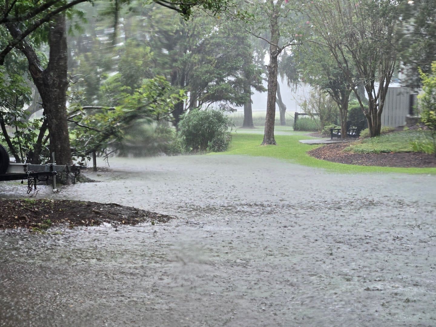
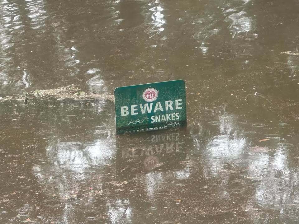
Photos & Video
 |
 |
 |
 |
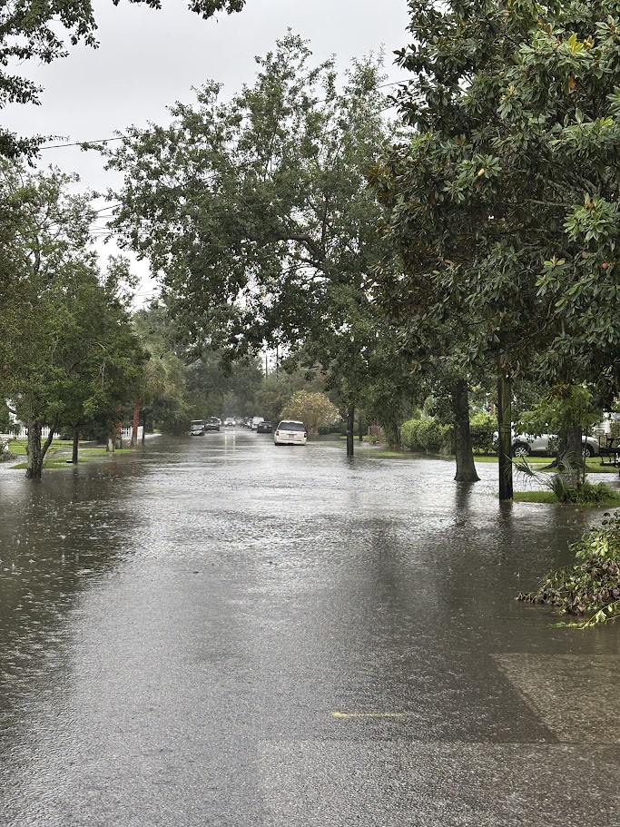
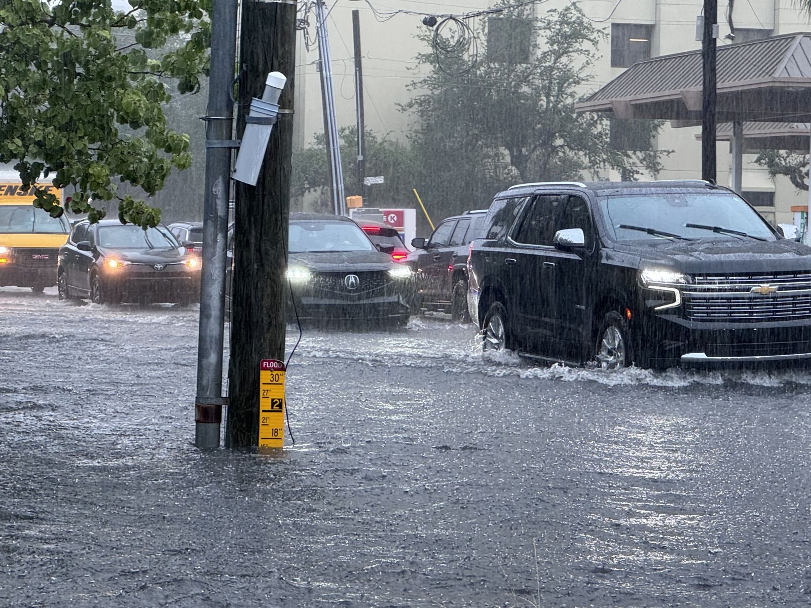
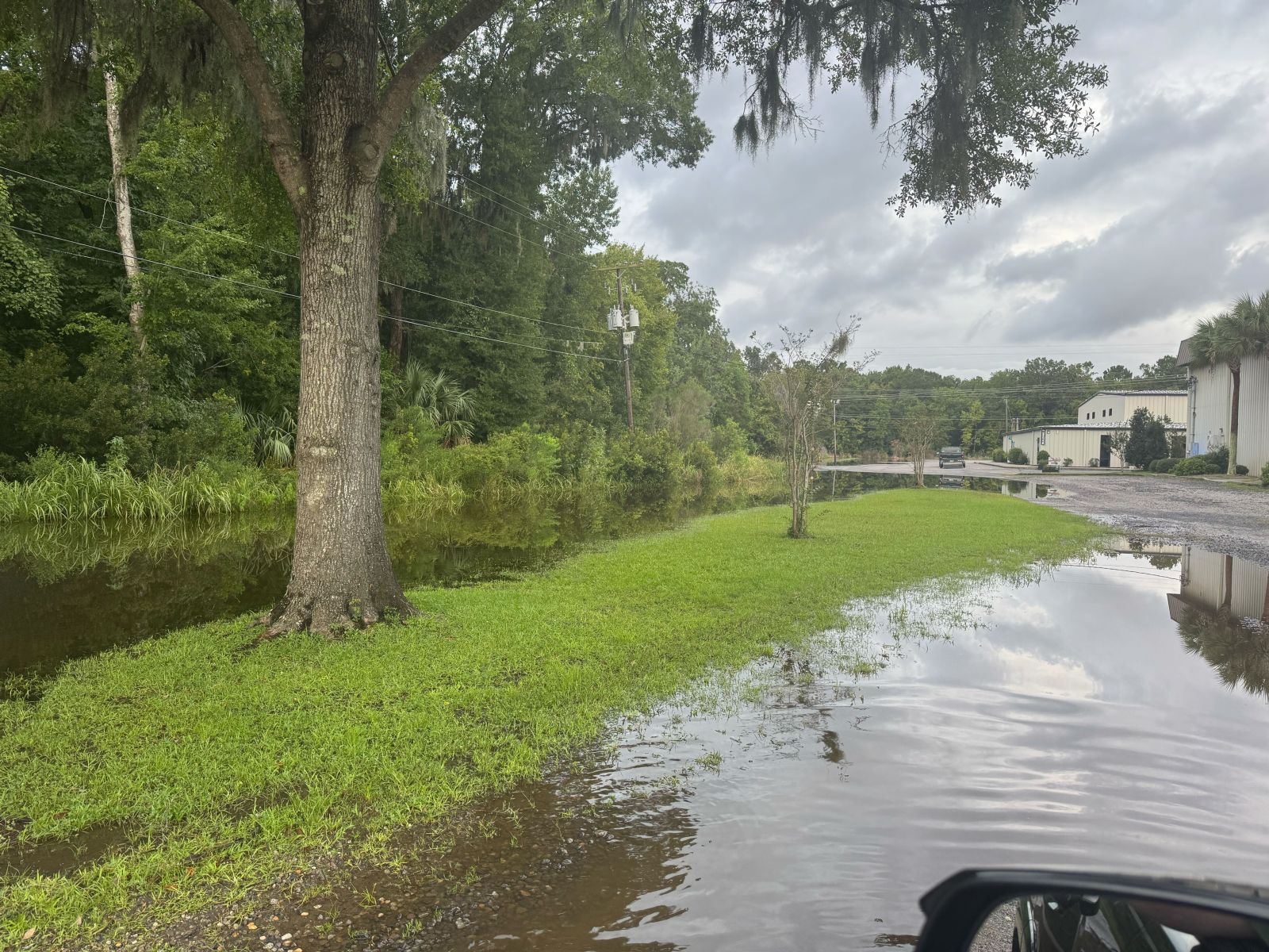
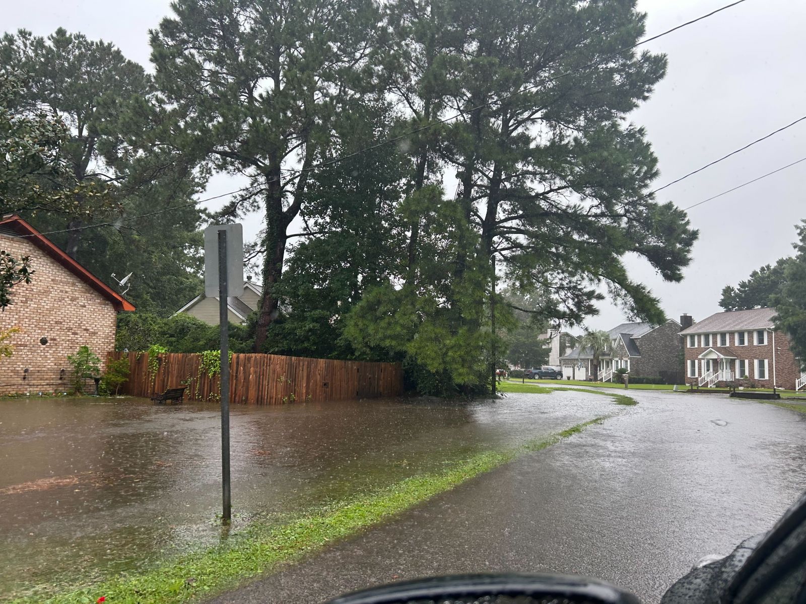
| Charleston, SC (Photo Courtesy of NWS Employee) |
Downtown Charleston, SC (Photo Courtesy of Charistin Clark) |
Charleston, SC (Photo Courtesy of NWS Employee) |
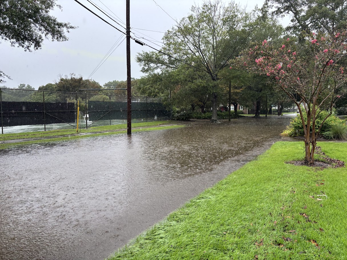
Buckingham Plantation, GA (Photo Courtesy of Chatham EMA) |
 |
 |
 |
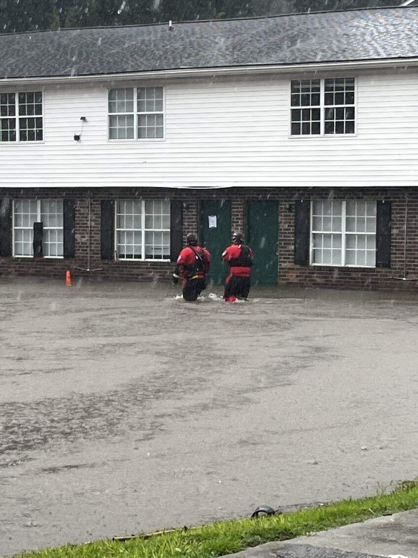 |
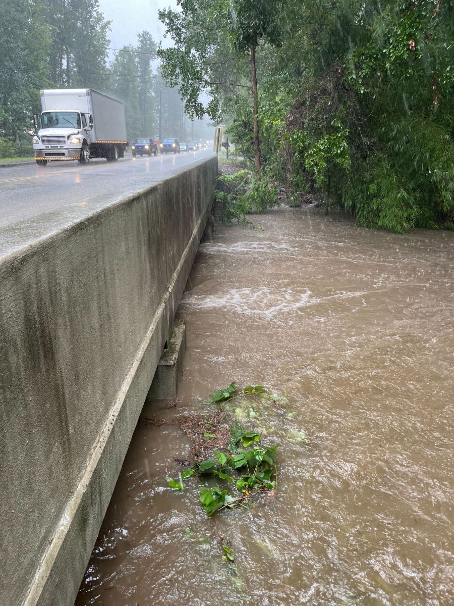
| Windsor Road, GA (Photo Courtesy of Chatham EMA) |
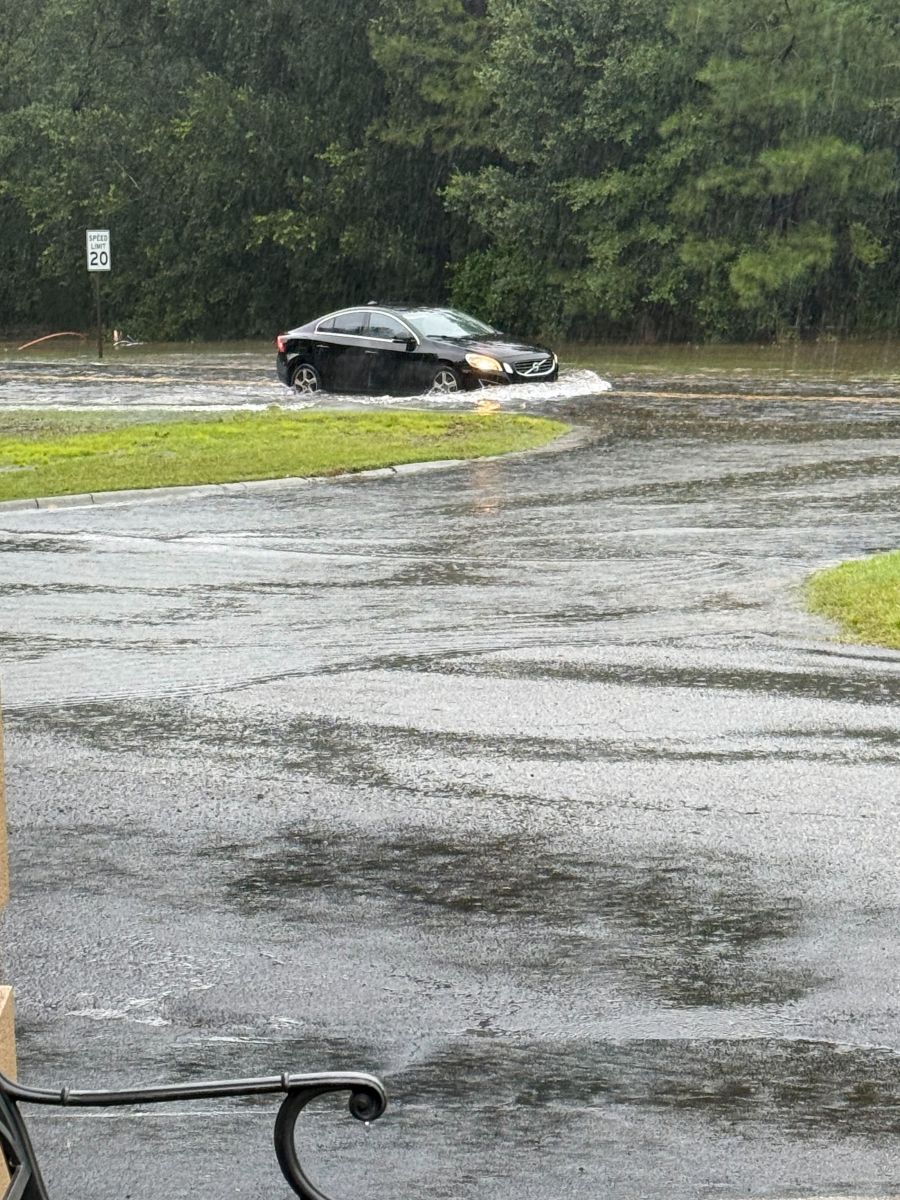
Shem Creek, SC (Photo Courtesy of Shannon Whitehead) |
Richmond Hill, GA near Sterling Creek (Photo Courtesy of Jamie Ertle) |
Summerville, SC (Photo Courtesy of Dorchester EMD) |
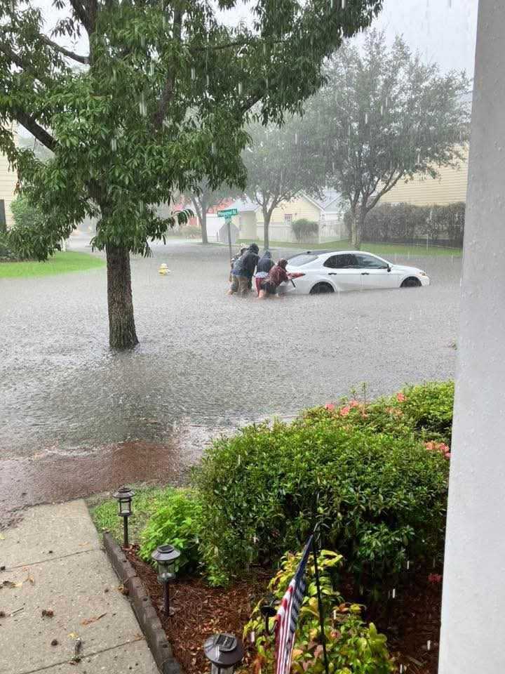 |
 |
 |
 |
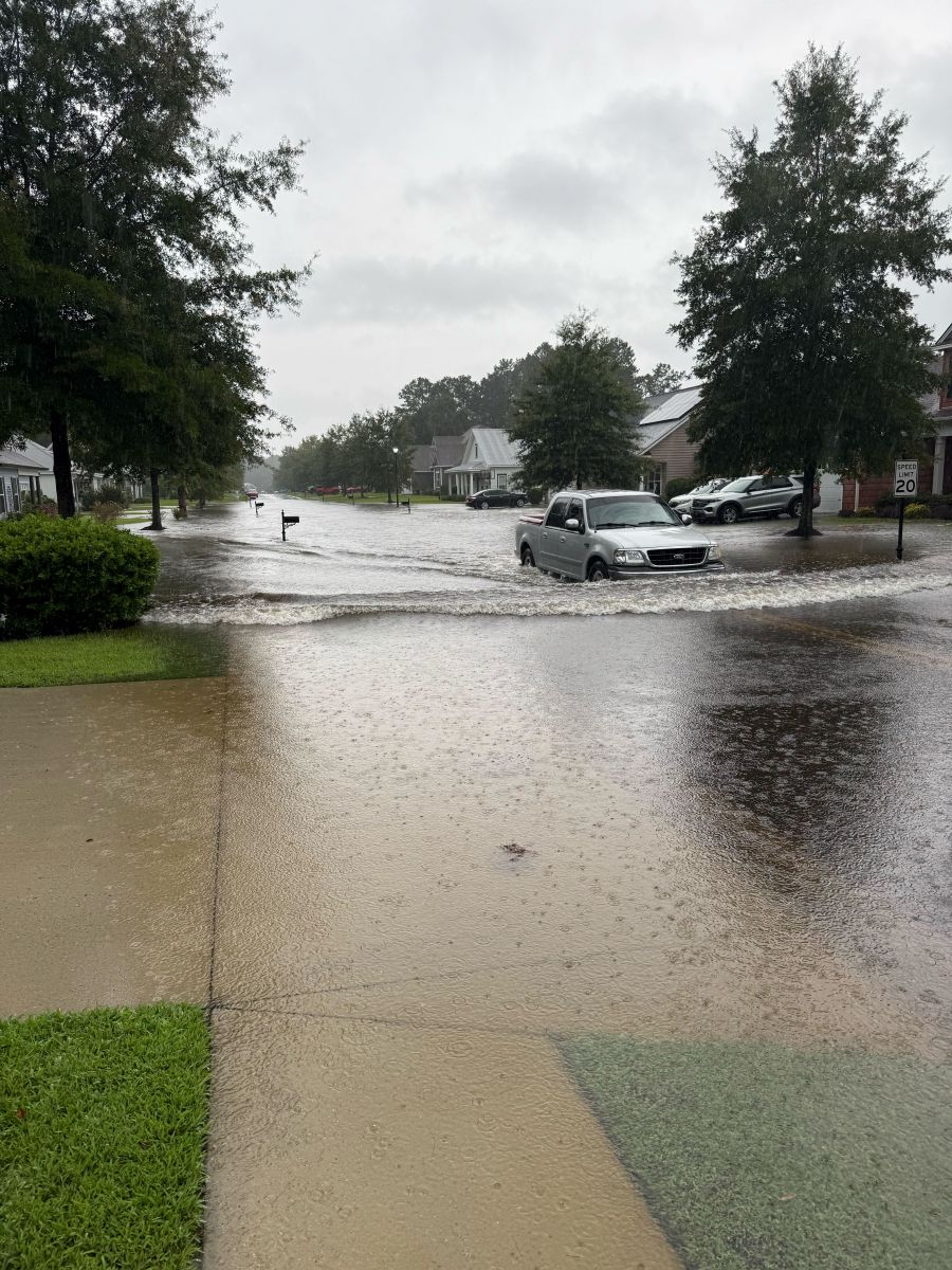
| Summerville, SC (Photo Courtesy of Dorchester EMA) |
Church Creek in West Ashley, SC (Photo Courtesy of NWS Employee) |
West Ashley, SC (Photo Courtesy of Charistin Clark) |
Rumphs Hill Creek, SC (Photo Courtesy of Dorchester EMD) |
Videos via Social Media
— Bill Walsh (@BILLWALSHTV) August 22, 2025
— Bill Burr (@BBonTV) August 22, 2025
— Trooper Bob (@TrooperBob_SC) August 22, 2025
— Trooper Bob (@TrooperBob_SC) August 22, 2025
 |
Media use of NWS Web News Stories is encouraged! Please acknowledge the NWS as the source of any news information accessed from this site. |
|


 Coastal Flood