WFO Charleston SC is making minor adjustments to public, fire weather, and marine zone shapefiles along the South Carolina and Georgia coasts in order to improve partner service and better match physical boundaries
1) The current shapefiles are unnecessarily complex, inconsistently handling features such as rivers, sounds, sandbars, islands, and piers. This can create confusion about what areas are considered marine and what are considered land for forecast purposes.
2) The current shapefiles do not reflect current physical boundaries. Processes such as coastal erosion, shoaling, and sand bar migration have resulted in features being incorrectly represented by our current shapefiles.
NWS Charleston has conducted a thorough review of zone boundaries along the South Carolina and Georgia coasts. The following adjustments have been made in order to
1. Remove areas that are not consistently dry (such as sandbars) from land zones.
2. Consistently include large inlets/sounds with their adjacent marine zones, and absorb very small creeks and rivers into the surrounding land zones.
3. Adjust zone boundaries to reflect current land extent (accounting for erosion and changing shorelines) and update zone numbers accordingly.
| Map of Previous Zone Boundaries | Map of New Zone Boundaries |
.png) |
.png) |
 |
 |
.png) |
 |
| Zone Name | Previous Zone Number | New Zone Number* |
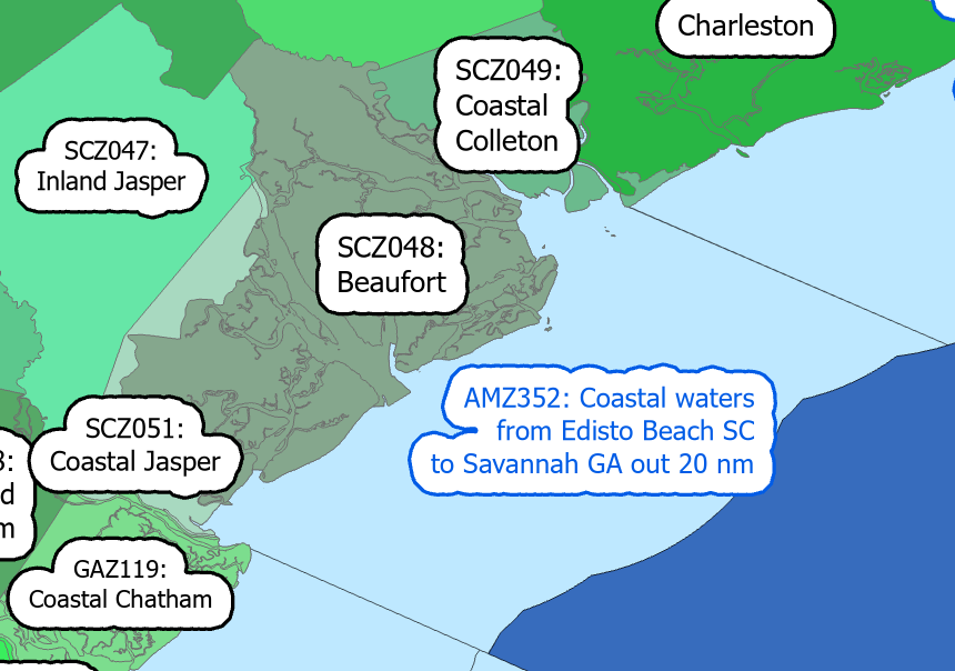
| Charleston | SCZ050 | SCZ150 |
| Tidal Berkeley | SCZ052 | SCZ152 |
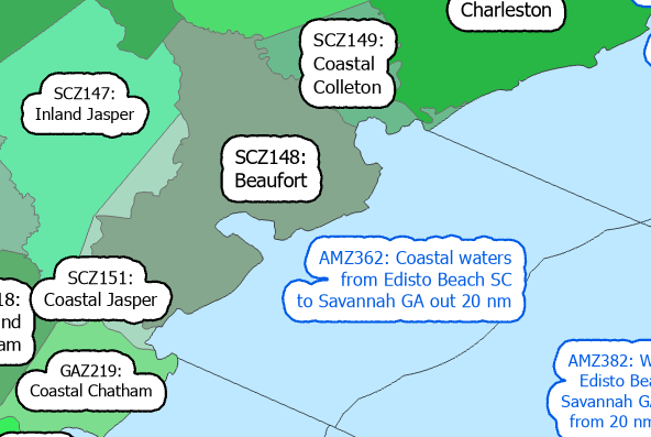
| Coastal Colleton | SCZ049 | SCZ149 |
| Beaufort | SCZ048 | SCZ148 |
| Coastal Jasper | SCZ051 | SCZ151 |
| Inland Jasper | SCZ047 | SCZ147 |
*effective on or around April 16, 2026
| Zone Name | Previous Zone Number | New Zone Number* |
| Inland Chatham | GAZ118 | GAZ218 |
| Coastal Chatham | GAZ119 | GAZ219 |
| Inland Bryan | GAZ116 | GAZ216 |
| Coastal Bryan | GAZ117 | GAZ217 |
| Inland Liberty | GAZ138 | GAZ238 |
| Coastal Liberty | GAZ139 | GAZ239 |
| Inland McIntosh | GAZ140 | GAZ240 |
| Coastal McIntosh | GAZ141 | GAZ241 |
*effective 4pm (EST) Tuesday, April 16, 2026
| Marine Zone Name | Previous Zone Number | New Zone Number* |
| Charleston Harbor | AMZ330 | AMZ340 |
| Coastal Waters from South Santee River to Edisto Beach SC out 20 NM | AMZ350 | AMZ360 |
| Coastal Waters from Edisto Beach SC to Savannah GA out 20 NM | AMZ352 | AMZ362 |
| Waters from Savannah GA to Altamaha Sound GA out 20 NM, including Grays Reef National Marine Sanctuary | AMZ354 | AMZ364 |
*effective 4pm (EST) on April 16, 2026
This change will have no significant impact on any official National Weather Service products.
The official Service Change Notice can be found here.
Click here for the Service Change Notice for the South Carolina offshore marine zone expansion from 40 NM to 60 NM offshore.


 Coastal Flood