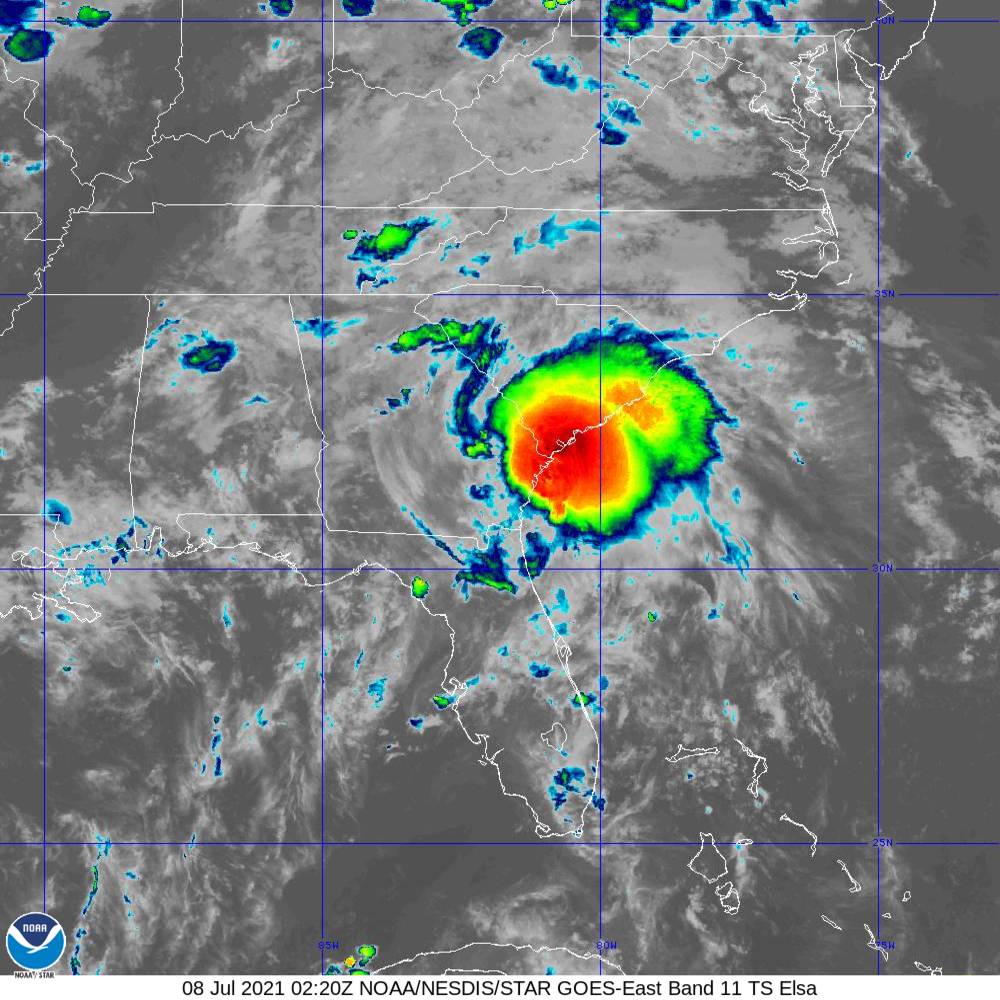
Tropical Storm Elsa made landfall in the Big Bend area of Florida and tracked north/northeast through southeast GA and central SC bringing some significant impacts to portions of the SC Lowcountry and GA Coastal Empire. Click here for our post tropical cyclone report.
Click the tornado icons on the map to display the damage survey summaries and on the tornado tracks for tornado details.

 |
 |
 |
 |
 |
| EF0 | EF1 | EF2 | EF3 | EF4 |
Public Information Statement...UPDATED
National Weather Service Charleston SC
234 PM EDT Wed Jul 21 2021


...NWS Damage Survey for 07/08/21 Tornado Event...

.Update...Updated times of Awendaw tornado

.Edisto Island...

Rating:                 EF1
Estimated Peak Wind:    95 mph
Path Length /statute/:  1.1183 miles
Path Width /maximum/:   100.0 yards
Fatalities:             0
Injuries:               0

Start Date:             07/08/2021
Start Time:             01:00 AM EDT
Start Location:         1 W Edisto Island / Charleston County / SC
Start Lat/Lon:          32.5627 / -80.2978

End Date:               07/08/2021
End Time:               01:02 AM EDT
End Location:           2 NW Edisto Island / Charleston County / SC
End Lat/Lon:            32.5789 / -80.2981

Survey Summary:
The beginning point for the tornado was detected by our NWS drone
in a corn field near the end of Sunnyside Mills Road. The tornado
had a discontinuous path northward across Store Creek, then
across a large corn field, ending near the intersection of
Cypress Trees Lane and Route 174. Along the path, there were many
hard and softwood trees snapped and uprooted, particularly near
Cypress Trees Lane, and also at a few residences toward the
beginning of the path, just south of Store Creek. The maximum
strength was estimated to be an EF1, with maximum winds of
95 mph, particularly toward the end of the path, just south of
Route 174.


.Awendaw...

Rating:                 EF1
Estimated Peak Wind:    95 mph
Path Length /statute/:  0.8195 miles
Path Width /maximum/:   150.0 yards
Fatalities:             0
Injuries:               0

Start Date:             07/08/2021
Start Time:             02:36 AM EDT
Start Location:         3 N Whitehall Terrace / Charleston County / SC
Start Lat/Lon:          32.9149 / -79.7314

End Date:               07/08/2021
End Time:               02:38 AM EDT
End Location:           4 N Whitehall Terrace / Charleston County / SC
End Lat/Lon:            32.9259 / -79.7367

Survey Summary:
The tornado touched down in the private community of Wando Farms,
where it snapped more than a dozen medium to large pine trees, and
snapped large limbs off of very large live oak trees. One resident
had the front door of their home blown in. The tornado then moved
north, and appeared to weaken, as it crossed the Wando River and
the surrounding marsh region. The tornado then ended near the
intersection of Ronlin Farm Road and Woodville Road, where it
snapped and uprooted several trees around a few homes. The
tornado was estimated to be an EF1, with maximum winds of 95 mph,
with the highest winds likely near the beginning of the path.
Public Information Statement
National Weather Service Charleston SC
805 PM EDT Fri Jul 9 2021


...NWS Damage Survey for 07/08/21 Tornado Event in Beaufort County...


.Paris Island...

Rating:                 EF1
Estimated Peak Wind:    97 mph
Path Length /statute/:  0.1344 miles
Path Width /maximum/:   50.0 yards
Fatalities:             0
Injuries:               0

Start Date:             07/07/2021
Start Time:             11:44 PM EDT
Start Location:         2 SSE Parris Island / Beaufort County /
SC
Start Lat/Lon:          32.3208 / -80.6741

End Date:               07/07/2021
End Time:               11:45 PM EDT
End Location:           2 SSE Parris Island / Beaufort County /
SC
End Lat/Lon:            32.3227 / -80.6745

Survey Summary:
This was a very short tornado path on the southern end of Paris Island,
which was likely the same storm that moved into Port Royal several
minutes later. However, the ground survey team could not confirm a
continuous path from Paris Island, northward to the Port Royal area.
Many softwood/pine trees were snapped in this location, which was directly
adjacent the old Page Field runway complex. The maximum strength was
estimated to be EF1, with winds of 97 mph.


.Port Royal...

Rating:                 EF1
Estimated Peak Wind:    95 mph
Path Length /statute/:  0.6259 miles
Path Width /maximum/:   75.0 yards
Fatalities:             0
Injuries:               0

Start Date:             07/07/2021
Start Time:             11:50 PM EDT
Start Location:         Port Royal / Beaufort County / SC
Start Lat/Lon:          32.3763 / -80.6915

End Date:               07/07/2021
End Time:               11:52 PM EDT
End Location:           Port Royal / Beaufort County / SC
End Lat/Lon:            32.3851 / -80.6941

Survey Summary:
This tornado was likely part of the same storm that hit Paris Island
just to the south. It began near 11th street, between Paris and
London Avenues, where it snapped trees, with one tree hitting a
home on 11th street. The tornado continued northward, across 14th
and 15th Streets, close to Paris Avenue. Many hardwood trees and
large limbs were snapped in this area, which also took down some
powerlines along Paris Avenue. The tornado then moved across the
southern portion of Paris Avenue West, snapping more trees and
limbs, some falling on a few homes/buildings. Finally, the
tornado crossed Ribaut Road, ending just north of the
intersection of Ribaut and Royal Palms Roads.  The maximum
strength was estimated to be EF1, with maximum winds of 95 mph.


&&
Public Information Statement
National Weather Service Charleston SC
525 PM EDT Fri Jul 9 2021

...NWS Damage Survey Confirms EF1 Tornado Damage Near Stillwell, GA...

Updated for start and end times.

Rating:                 EF1
Estimated Peak Wind:    105 mph
Path Length /statute/:  1.9 miles
Path Width /maximum/:   100.0 yards
Fatalities:             0
Injuries:               0

Start Date:             07/07/2021
Start Time:             10:48 PM EDT
Start Location:         2 WSW Stillwell / Effingham County / GA
Start Lat/Lon:          32.3721 / -81.2832

End Date:               07/07/2021
End Time:               10:50 PM EDT
End Location:           3 SW Berryville / Effingham County / GA
End Lat/Lon:            32.3984 / -81.2951

Survey Summary:
A National Weather Service storm survey confirmed an EF1 Tornado
in Springfield, GA, with a path length of nearly 2 miles, width
of 100 yards, and peak winds of 105 mph. The tornado began just
north of Stillwell Road and east of Mock Road at Mose Mock Farms
where the tops of several trees were sheared off, large branches
were knocked down, and a carport collapsed. The tornado then
moved northwest, snapping and uprooting several trees along Mock
Road and in a field near a power line easement. The tornado then
strengthened to EF1 intensity as it turned north and moved along
Wood Duck Way. Multiple homes on Wood Duck Way and Riley Court
suffered minor roof and siding damage, two boats on trailers were
lifted and knocked over or overturned, a carport collapsed, and
numerous trees were uprooted or snapped. The tornado then
continued northward, crossing GA Highway 119 where it snapped and
uprooted a few trees and knocked down powerlines, before
dissipating in a field just north of the highway.
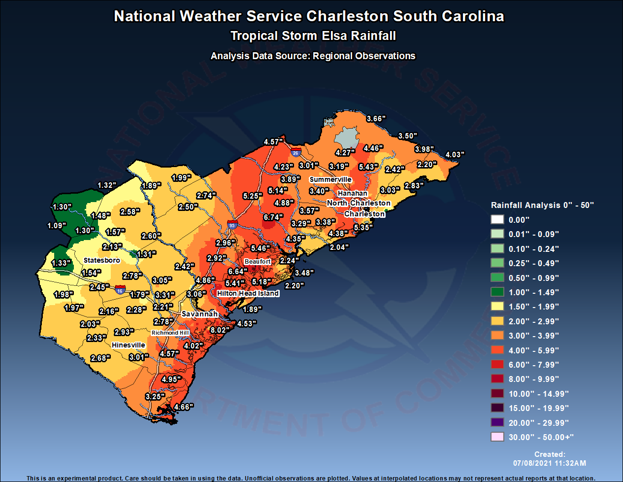
Public Information Statement
National Weather Service Charleston SC
1002 AM EDT Thu Jul 8 2021

...24 HOUR PRECIPITATION TOTALS...

Location                     Amount    Time/Date       Provider

...Georgia...

...Bryan County...
Richmond Hill 7.0 ESE        4.02 in   0800 AM 07/08   COCORAHS
Richmond Hill 0.5 NE         3.62 in   0700 AM 07/08   COCORAHS
Richmond Hill 9 WNW          2.93 in   0930 AM 07/08   USGS
Richmond Hill                2.78 in   0934 AM 07/08   RAWS
Blitchton 4 WSW              2.58 in   0900 AM 07/08   USGS
Pembroke                     2.28 in   0934 AM 07/08   RAWS
Ellabell 7 SE                2.21 in   0915 AM 07/08   USGS
Eden                         1.92 in   0915 AM 07/08   USGS
Blitchton 4 WSW              1.79 in   0915 AM 07/08   USGS

...Bulloch County...
Brooklet 8.5 SE              2.78 in   0700 AM 07/08   COCORAHS
Nevils 3.1 S                 2.45 in   0730 AM 07/08   COCORAHS
Brooklet 1 W                 2.24 in   0900 AM 07/08   COOP
Statesboro 4.4 N             2.13 in   0715 AM 07/08   COCORAHS
Statesboro 5.7 S             1.54 in   0700 AM 07/08   COCORAHS
Oliver 1 SW                  1.31 in   0930 AM 07/08   USGS
Rocky Ford                   1.30 in   0900 AM 07/08   USGS

...Candler County...
Metter                       1.33 in   0903 AM 07/08   RAWS

...Chatham County...
Skidaway Island 0.8 NE       8.02 in   0630 AM 07/08   COCORAHS
Savannah 2.0 SSE             7.50 in   0700 AM 07/08   COCORAHS
Savannah 9.6 E               6.55 in   0700 AM 07/08   COCORAHS
Savannah 8.2 SSE             5.65 in   0800 AM 07/08   COCORAHS
Savannah 10.4 E              5.32 in   0800 AM 07/08   COCORAHS
Savannah 7.9 SSE             5.04 in   0700 AM 07/08   COCORAHS
Savannah 4.7 ESE             4.57 in   0700 AM 07/08   COCORAHS
Tybee Island 0.7 NNE         4.53 in   0700 AM 07/08   COCORAHS
Hunter Army Air Field        4.39 in   0956 AM 07/08   AWOS
Savannah 3.3 SE              4.30 in   0700 AM 07/08   COCORAHS
Savannah 2.0 SW              4.29 in   0700 AM 07/08   COCORAHS
Coffee Bluff                 4.27 in   0700 AM 07/08   COCORAHS
Savannah 3.9 SSW             4.20 in   0700 AM 07/08   COCORAHS
Lepageville                  4.10 in   0955 AM 07/08   AWS
Savannah 5.9 SSW             4.08 in   0700 AM 07/08   COCORAHS
Savannah 1.7 W               3.70 in   0700 AM 07/08   COCORAHS
Savannah 3.1 ENE             3.69 in   0700 AM 07/08   COCORAHS
Savannah 6.3 WNW             3.58 in   0700 AM 07/08   COCORAHS
Savannah                     3.56 in   0952 AM 07/08   CWOP
Skidaway Island              3.18 in   0950 AM 07/08   AWS
Savannah 2.3 SSW             3.09 in   0700 AM 07/08   COCORAHS
Garden City 1.2 NNE          2.92 in   0700 AM 07/08   COCORAHS
Pooler 1.2 NNE               2.75 in   0700 AM 07/08   COCORAHS
Savannah Intl Airport        2.56 in   0953 AM 07/08   ASOS
Limehouse                    2.15 in   0930 AM 07/08   USGS
Port Wentworth 2 ESE         2.06 in   0900 AM 07/08   USGS
1 SE Parkersburg             1.95 in   0950 AM 07/08   AWS
Port Wentworth 1 NE          1.78 in   0930 AM 07/08   USGS
2 NE Pooler                  1.75 in   0955 AM 07/08   AWS

...Effingham County...
Guyton 12.0 SE               3.31 in   0659 AM 07/08   COCORAHS
Marlow 0.0 S                 3.05 in   0800 AM 07/08   COCORAHS
Rincon                       2.42 in   0954 AM 07/08   CWOP
Springfield 2.4 E            2.42 in   0700 AM 07/08   COCORAHS
Rincon 4 SE                  2.06 in   0945 AM 07/08   USGS
Abercorn Creek               1.83 in   0900 AM 07/08   USGS
Port Wentworth 6 N           1.82 in   0945 AM 07/08   USGS

...Evans County...
Glissons Pond                2.16 in   0934 AM 07/08   RAWS
Bellville 2.8 N              1.98 in   0700 AM 07/08   COCORAHS
Claxton 0.5 WSW              1.97 in   0800 AM 07/08   COCORAHS

...Jenkins County...
Sardis                       1.32 in   0900 AM 07/08   USGS
Midville 6.6 ESE             1.30 in   0700 AM 07/08   COCORAHS
1 WNW Four Points            1.09 in   0945 AM 07/08   AWS

...Liberty County...
Midway 3.8 NE                4.57 in   0800 AM 07/08   COCORAHS
Midway                       3.01 in   0904 AM 07/08   RAWS
Lawson                       2.93 in   0934 AM 07/08   RAWS
Fort Stewart                 2.62 in   0856 AM 07/08   AWOS
Statesboro                   2.03 in   0952 AM 07/08   CWOP
McIntosh                     1.90 in   0915 AM 07/08   USGS

...Long County...
Ludowici                     2.68 in   0954 AM 07/08   CWOP
Taylors Creek                2.33 in   0934 AM 07/08   RAWS

...McIntosh County...
Townsend 5.5 SE              4.95 in   0701 AM 07/08   COCORAHS
Nerrs Meteorological Site On 4.66 in   0900 AM 07/08   HADS
Valona                       3.25 in   0950 AM 07/08   AWS

...Screven County...
Newington 0.5 SSE            2.60 in   0700 AM 07/08   COCORAHS
Sylvania 0.8 W               2.58 in   0800 AM 07/08   COCORAHS
Burtons Ferry                1.89 in   0845 AM 07/08   USGS
Rocky Ford 4 SE              1.57 in   0628 AM 07/08   COOP
Rocky Ford 4.2 N             1.48 in   0700 AM 07/08   COCORAHS

...South Carolina...

...Allendale County...
Allendale 1.7 SE             1.99 in   0600 AM 07/08   COCORAHS

...Beaufort County...
Beaufort 1.6 SSW             7.15 in   0600 AM 07/08   COCORAHS
Bluffton 6.2 WNW             6.64 in   0700 AM 07/08   COCORAHS
Beaufort 4.2 WSW             6.64 in   0800 AM 07/08   COCORAHS
Bluffton 7.2 WNW             6.39 in   0549 AM 07/08   COCORAHS
Bluffton 7.0 W               6.34 in   0700 AM 07/08   COCORAHS
Bluffton 5.1 NW              5.92 in   0830 AM 07/08   COCORAHS
Parris Island 1.7 N          5.88 in   0700 AM 07/08   COCORAHS
Hilton Head Island 4.0 N     5.85 in   0700 AM 07/08   COCORAHS
Hilton Head Island 4.1 NE    5.80 in   0700 AM 07/08   COCORAHS
Beaufort 4.5 NE              5.58 in   0800 AM 07/08   COCORAHS
Beaufort 5.7 NE              5.46 in   0900 AM 07/08   COCORAHS
Bluffton 2.9 ENE             5.41 in   0800 AM 07/08   COCORAHS
Hilton Head Island 4.4 NNE   5.18 in   0800 AM 07/08   COCORAHS
Bluffton 0.7 NNW             4.77 in   0800 AM 07/08   COCORAHS
Hilton Head Island 5.1 NW    4.47 in   0700 AM 07/08   COCORAHS
Beaufort MCAS                4.20 in   0956 AM 07/08   AWOS
1 E Hilton Head Island       4.00 in   0955 AM 07/08   AWS
Saint Helena 7.0 E           3.48 in   0700 AM 07/08   COCORAHS
Hilton Head Island           3.09 in   0945 AM 07/08   CWOP
Sheldon 3.7 SSW              2.96 in   0700 AM 07/08   COCORAHS
Hilton Head                  2.37 in   0953 AM 07/08   CWOP
St Helena Island 2.8 NE      2.24 in   0600 AM 07/08   COCORAHS
Fripp Island 0.5 WSW         2.20 in   0630 AM 07/08   COCORAHS
Hilton Head Island           1.89 in   0949 AM 07/08   CWOP

...Berkeley County...
Hanahan 1.7 SE               5.50 in   0800 AM 07/08   COCORAHS
Moncks Corner 8.9 S          5.43 in   0800 AM 07/08   COCORAHS
Charleston                   4.85 in   0951 AM 07/08   CWOP
Charleston 9.1 NE            4.48 in   0700 AM 07/08   COCORAHS
Moncks Corner 3.6 E          4.46 in   0700 AM 07/08   COCORAHS
Moncks Corner 0.8 ESE        4.27 in   0800 AM 07/08   COCORAHS
Charleston                   3.98 in   0952 AM 07/08   CWOP
Summerville 3.3 NE           3.95 in   0900 AM 07/08   COCORAHS
Daniel Island 1.0 SE         3.86 in   0600 AM 07/08   COCORAHS
Summerville 5.5 NNW          3.84 in   0800 AM 07/08   COCORAHS
St. Stephen 0.4 ENE          3.66 in   0700 AM 07/08   COCORAHS
Charleston 6.8 NE            3.65 in   0600 AM 07/08   COCORAHS
Jamestown                    3.50 in   0700 AM 07/08   COOP
Moncks Corner 5.1 SSW        3.37 in   0700 AM 07/08   COCORAHS
Goose Creek                  3.28 in   0950 AM 07/08   CWOP
Summerville 5.0 NNE          3.19 in   0700 AM 07/08   COCORAHS
2 NNE Daniel Island          2.64 in   0950 AM 07/08   AWS
Witherbee                    2.54 in   0913 AM 07/08   RAWS
Huger 3 ENE                  2.42 in   0900 AM 07/08   USGS

...Charleston County...
Charleston 2.5 NNW           6.18 in   0620 AM 07/08   COCORAHS
Charleston 2.9 NNE           5.75 in   0700 AM 07/08   COCORAHS
Charleston 1.6 SSW           5.63 in   0800 AM 07/08   COCORAHS
North Charleston 3.1 ESE     5.63 in   0700 AM 07/08   COCORAHS
Charleston 0.3 ESE           5.61 in   0700 AM 07/08   COCORAHS
North Charleston 3.5 ESE     5.60 in   0700 AM 07/08   COCORAHS
North Charleston 3.1 E       5.52 in   0730 AM 07/08   COCORAHS
Johns Island 1.8 NE          5.35 in   0715 AM 07/08   COCORAHS
Charleston 4.0 NW            5.29 in   0700 AM 07/08   COCORAHS
Charleston 2.9 W             5.24 in   0600 AM 07/08   COCORAHS
Oakland                      5.11 in   0847 AM 07/08   COCORAHS
Charleston 1.7 SE            4.88 in   0800 AM 07/08   COCORAHS
North Charleston 4.0 SSE     4.84 in   0700 AM 07/08   COCORAHS
Charleston 5.0 WNW           4.75 in   0700 AM 07/08   COCORAHS
Charleston 3.8 NW            4.60 in   0800 AM 07/08   COCORAHS
NWS Charleston SC            4.60 in   0700 AM 07/08   COCORAHS
Johns Island 3.3 WNW         4.59 in   0700 AM 07/08   COCORAHS
Wadmalaw Island 4.1 NE       4.56 in   0800 AM 07/08   COCORAHS
Wadmalaw Island 3.6 ENE      4.38 in   0700 AM 07/08   COCORAHS
Charleston 6.4 WNW           4.35 in   0915 AM 07/08   COCORAHS
Charleston 5.2 WNW           4.23 in   0800 AM 07/08   COCORAHS
Charleston Intl Airport      4.12 in   0856 AM 07/08   ASOS
SANTEE COAST MCCLELLANVILLE  4.03 in   0905 AM 07/08   HADS
North Charleston 3.5 N       3.78 in   0800 AM 07/08   COCORAHS
Mount Pleasant 1.0 WSW       3.70 in   0800 AM 07/08   COCORAHS
Ravenel 2.0 WNW              3.57 in   0700 AM 07/08   COCORAHS
Mount Pleasant               3.42 in   0950 AM 07/08   CWOP
Meggett 1.8 W                3.38 in   0800 AM 07/08   COCORAHS
Ravenel                      3.30 in   0951 AM 07/08   CWOP
Summerville 2.6 E            3.29 in   0700 AM 07/08   COCORAHS
Hollywood 5.8 WSW            3.29 in   0900 AM 07/08   COCORAHS
Charleston 4.6 SSE           3.18 in   0800 AM 07/08   COCORAHS
Wadmalaw Island 2.3 SSW      3.18 in   0730 AM 07/08   COCORAHS
Mount Pleasant 1.7 N         3.16 in   0700 AM 07/08   COCORAHS
Charleston 5.9 ESE           3.14 in   0840 AM 07/08   COCORAHS
Mount Pleasant 6.1 NNE       3.06 in   0652 AM 07/08   COCORAHS
Mount Pleasant 6.4 NE        3.05 in   0800 AM 07/08   COCORAHS
Mount Pleasant 1.9 N         3.04 in   0700 AM 07/08   COCORAHS
Mount Pleasant 7.0 NE        3.03 in   0800 AM 07/08   COCORAHS
North Charleston 3.5 ESE     2.98 in   0728 AM 07/08   COCORAHS
Charleston 5.2 ESE           2.96 in   0644 AM 07/08   COCORAHS
Mount Pleasant               2.92 in   0954 AM 07/08   CWOP
Mount Pleasant               2.90 in   0945 AM 07/08   CWOP
Charleston 5.4 SSE           2.89 in   0600 AM 07/08   COCORAHS
Mount Pleasant 8.2 NE        2.83 in   0700 AM 07/08   COCORAHS
Wambaw                       2.83 in   0947 AM 07/08   RAWS
Mount Pleasant 8.1 NE        2.82 in   0752 AM 07/08   COCORAHS
Mount Pleasant 7.5 NE        2.80 in   0630 AM 07/08   COCORAHS
Mount Pleasant 2.0 N         2.78 in   0640 AM 07/08   COCORAHS
Mount Pleasant 4.1 NE        2.76 in   0700 AM 07/08   COCORAHS
Mount Pleasant 1.4 ENE       2.67 in   0759 AM 07/08   COCORAHS
Mount Pleasant 4.6 NNE       2.65 in   0800 AM 07/08   COCORAHS
Charleston                   2.50 in   0954 AM 07/08   AWS
Charleston 5.4 SE            2.47 in   0806 AM 07/08   COCORAHS
Hollywood 4.3 SE             2.42 in   0700 AM 07/08   COCORAHS
Mount Pleasant               2.38 in   0951 AM 07/08   CWOP
Edisto Beach 5.1 NNW         2.33 in   0700 AM 07/08   COCORAHS
Mount Pleasant               2.30 in   0951 AM 07/08   CWOP
Edisto Beach 2.7 N           2.20 in   0700 AM 07/08   COCORAHS
McClellanville 0.5 ESE       2.20 in   0700 AM 07/08   COCORAHS
Charleston                   2.19 in   0955 AM 07/08   AWS
Edisto Island 3.2 NNE        2.12 in   0900 AM 07/08   COCORAHS
Seabrook Island 0.2 S        2.11 in   0700 AM 07/08   COCORAHS
Mount Pleasant 2.7 S         2.11 in   0900 AM 07/08   COCORAHS
Seabrook Island              2.04 in   0950 AM 07/08   AWS
Charleston                   2.02 in   0955 AM 07/08   AWS
Mount Pleasant 1.9 ESE       2.02 in   0822 AM 07/08   COCORAHS
1 SE Edisto Island           1.98 in   0700 AM 07/08   COCORAHS
Snowden                      1.63 in   0950 AM 07/08   AWS
Isle Of Palms 0.1 E          1.49 in   0800 AM 07/08   COCORAHS
Isle of Palms                1.22 in   0945 AM 07/08   CWOP

...Colleton County...
Green Pond 1.3 S             6.74 in   0800 AM 07/08   COCORAHS
Walterboro 3.0 NNW           5.60 in   0700 AM 07/08   COCORAHS
Walterboro 2.2 ENE           5.25 in   0730 AM 07/08   COCORAHS
Walterboro                   5.14 in   0707 AM 07/08   RAWS
Cottageville 5.8 WSW         4.88 in   0700 AM 07/08   COCORAHS
Bennetts Point               4.35 in   0845 AM 07/08   HADS
Grover 4.4 SE                4.23 in   0800 AM 07/08   COCORAHS
Cottageville 3.1 NNW         2.90 in   0845 AM 07/08   COCORAHS
Walterboro 1 SW              2.40 in   0700 AM 07/08   COOP

...Dorchester County...
Summerville                  4.85 in   0954 AM 07/08   CWOP
North Charleston 4.4 W       4.58 in   0751 AM 07/08   COCORAHS
Saint George                 4.57 in   0954 AM 07/08   CWOP
Givhans                      3.89 in   0945 AM 07/08   CWOP
Summerville 3.2 WNW          3.82 in   0756 AM 07/08   COCORAHS
Summerville 5.7 SSE          3.70 in   0700 AM 07/08   COCORAHS
Summerville 2.1 WSW          3.64 in   0600 AM 07/08   COCORAHS
Summerville 0.4 SSW          3.55 in   0700 AM 07/08   COCORAHS
Summerville                  3.50 in   0950 AM 07/08   CWOP
Summerville 1.4 SSW          3.48 in   0800 AM 07/08   COCORAHS
Summerville 3.4 S            3.45 in   0845 AM 07/08   COCORAHS
Summerville 1.9 SSW          3.40 in   0600 AM 07/08   COCORAHS
Summerville 2.0 SW           3.40 in   0700 AM 07/08   COCORAHS
Ridgeville 3.2 WSW           3.01 in   0600 AM 07/08   COCORAHS
Summerville                  2.57 in   0953 AM 07/08   CWOP

...Hampton County...
Hampton                      2.74 in   0950 AM 07/08   CWOP
Hampton 0.2 SW               2.50 in   0700 AM 07/08   COCORAHS
Hampton 0.8 SW               2.46 in   0700 AM 07/08   COCORAHS

...Jasper County...
Bluffton 7.2 NW              5.31 in   0800 AM 07/08   COCORAHS
Hardeeville 6.7 ENE          4.86 in   0700 AM 07/08   COCORAHS
Elba Island                  3.42 in   0930 AM 07/08   USGS
Savannah NWR                 3.10 in   0923 AM 07/08   RAWS
Limehouse 4 SW               3.06 in   0845 AM 07/08   USGS
Ridgeland 5.8 ESE            2.92 in   0530 AM 07/08   COCORAHS

...Maritime Stations...
Kiawah Island 1.0 SW         3.38 in   0700 AM 07/08   COCORAHS
Charleston                   1.31 in   0953 AM 07/08   CWOP
Public Information Statement
National Weather Service Charleston SC
948 AM EDT Thu Jul 8 2021

...PEAK WINDS DURING THE LAST 24 HOURS...

Location                     Speed     Time/Date       Provider
Calibogue Sound              81 MPH    1113 PM 07/07   WXFLOW
South Tybee Island           74 MPH    1102 PM 07/07   WXFLOW
Capers Nearshore Buoy        60 MPH    0623 AM 07/08   NDBC
North Tybee Island           52 MPH    1108 PM 07/07   WXFLOW
Beaufort MCAS                51 MPH    0247 AM 07/08   AWOS
Beaufort                     50 MPH    0240 AM 07/08   WXFLOW
Fripp Nearshore Buoy         49 MPH    0408 AM 07/08   NDBC
Fort Sumter                  49 MPH    0451 AM 07/08   WXFLOW
1.1 SW Remleys Point (SCDOT) 48 MPH    0515 AM 07/08   MESOWEST
Isle of Palms                48 MPH    0541 AM 07/08   WXFLOW
Buoy 41008                   47 MPH    1050 PM 07/07   NDBC
Charleston Intl Airport      47 MPH    0203 AM 07/08   ASOS
Beaufort                     44 MPH    0315 AM 07/08   AWOS
Hilton Head Airport          44 MPH    1155 PM 07/07   AWOS
Mount Pleasant               44 MPH    0535 AM 07/08   AWOS
Savannah Intl Airport        44 MPH    1027 PM 07/07   ASOS
3 ESE Secessionville         43 MPH    0500 AM 07/08   NDBC
Charleston Exec              43 MPH    0455 AM 07/08   AWOS
Hunter Army Air Field        43 MPH    1009 PM 07/07   AWOS
Battery Point                42 MPH    0424 AM 07/08   WXFLOW
Mount Pleasant               39 MPH    0432 AM 07/08   CWOP
Don Holt Fog 4               39 MPH    0445 AM 07/08   MESOWEST
2.2 NW Charleston (SCDOT)    38 MPH    0445 AM 07/08   MESOWEST
Isle of Palms                37 MPH    0915 AM 07/08   CWOP
Savannah NWR                 37 MPH    0123 AM 07/08   RAWS
Swinton Smith Field At Reids 36 MPH    1015 PM 07/07   MESOWEST
2.4 SE Burton (WEATHERSTEM)  34 MPH    1220 AM 07/08   MESOWEST
I-95 At Chatham Weigh Statio 34 MPH    0240 AM 07/08   MESOWEST
Statesboro                   33 MPH    0437 AM 07/08   CWOP
Savannah                     32 MPH    0105 AM 07/08   CWOP
Metter Municipal Airport     32 MPH    1015 PM 07/07   MESOWEST
Moncks Corner                31 MPH    0235 AM 07/08   AWOS
Glissons Pond                30 MPH    0104 AM 07/08   RAWS
Fort Stewart                 30 MPH    0222 AM 07/08   AWOS


 Coastal Flood