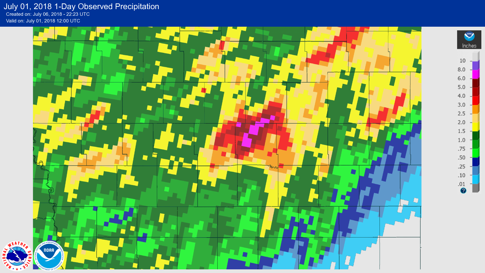
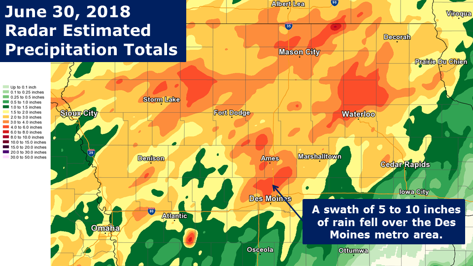
OverviewThe Des Moines Metro area saw epic flash flooding on the night of June 30 into the early hours of July 1, 2018 as thunderstorms stalled over the city and dropped significant heavy rain. A widespread swath of 5 to 10 inches fell over the northern half of Polk County and obliterated many creeks. Record stages were set on the Walnut and Fourmile Creeks in Clive and Ankeny, respectively. Dozens of vehicles were stalled or swept away by the rapid currents and multiple homes throughout much of Polk County were impacted by the heavy rain.
|
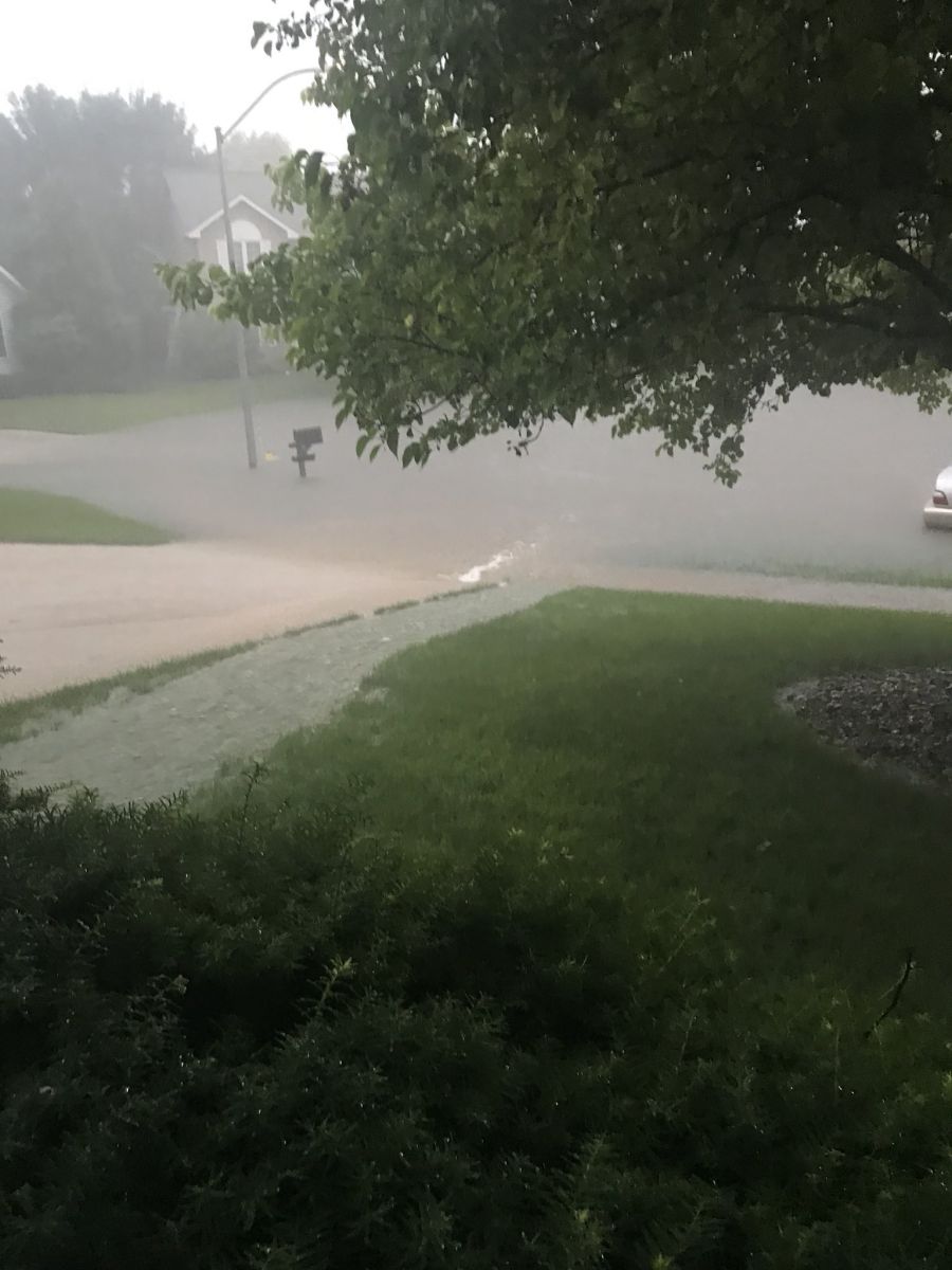
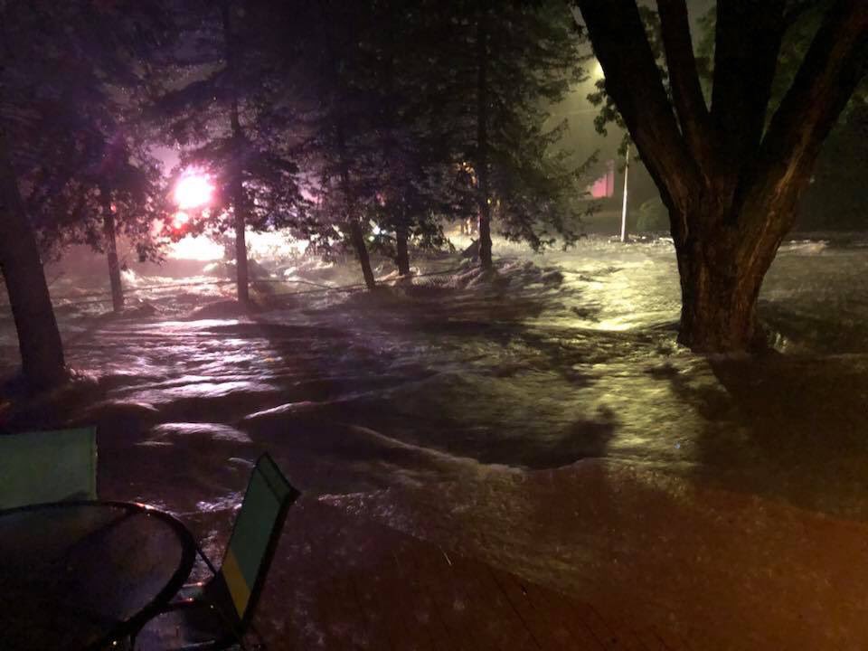 Major flash flooding in Urbandale, Iowa on June 30, 2018. Photo courtesy Stephanie Boutard |
Photos:
 |
 |
 |
 |
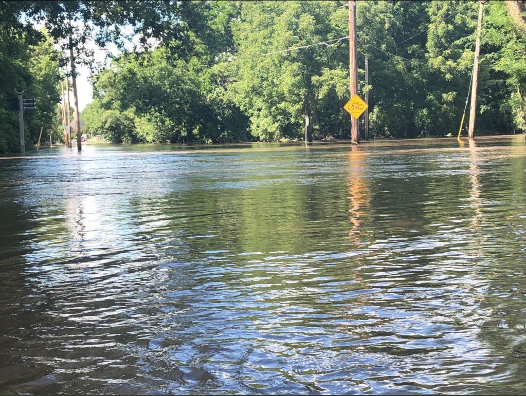
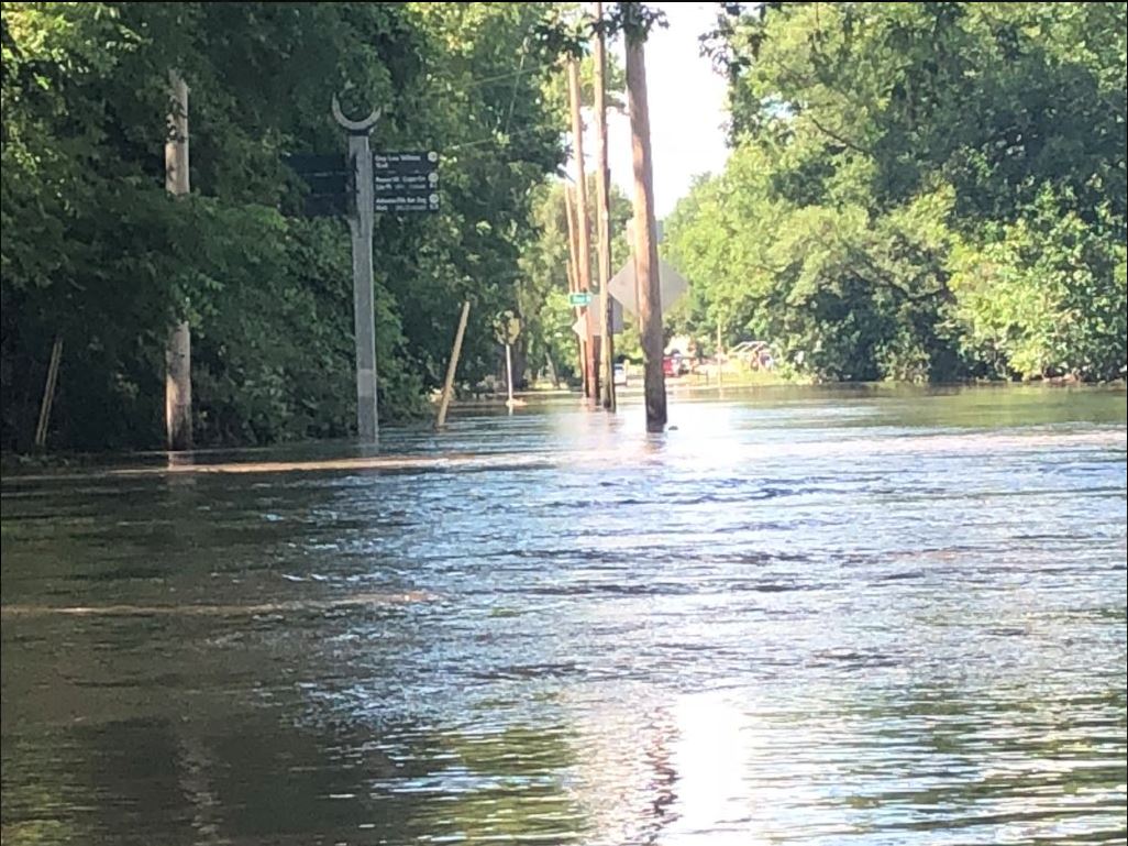
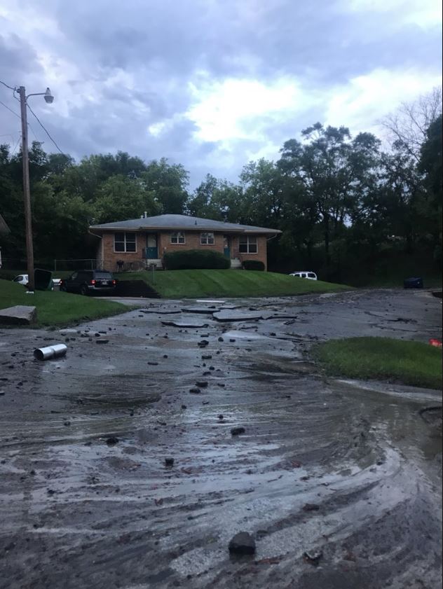
| Fourmile Creek at 4 Mile Drive and Williams Street on Sunday afternoon, July 1, 2018. | Fourmile Creek at 4 Mile Drive and Williams Street on Sunday afternoon, July 1, 2018. | Urbandale, Iowa aftermath of the flash flooding. | Urbandale, Iowa on June 30, 2018. Photo by Jeff Jaeger. |
 |
 |
 |
 |
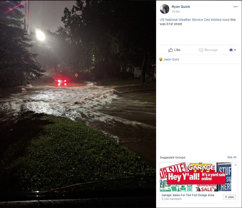
| NW 9th street and School in Ankeny, Iowa. Photo by @JnJ4cy via Twitter. | 61st near Merle Hay Mall. Photo by Ryan Quick. | 61st near Merle Hay Mall on the evening of June 30, 2018. Photo by Ryan Quick. | Washed away vehicle on Pioneer Parkway in Johnston. Photo courtesy of Andrew Batt via Twitter. |
 |
 |
 |
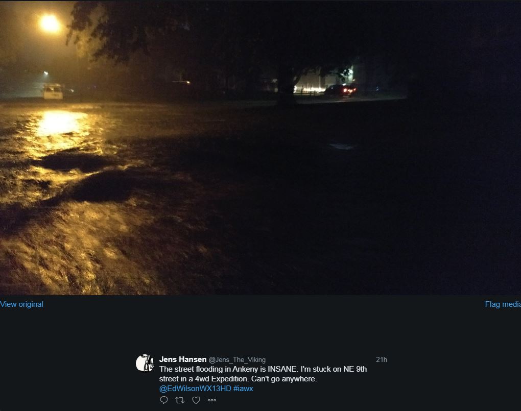 |
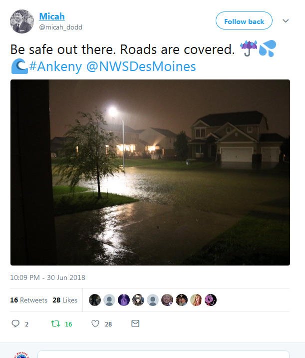
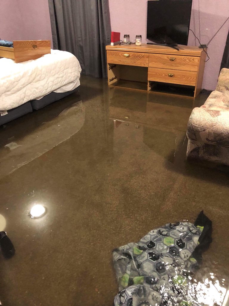
| Ankeny, Iowa around 10 p.m. June 30, 2018 | Flash flooding Johnston just east of the new high school. | Flooded bedroom in Ankeny. Photo by Ashley Reimers via Megan Salois (WHO Weather). | NE 9th in Ankeny. Photo by Jens Hansen. |
Radar:
Radar loop(s) and images of the thunderstorms that produced heavy rain and flash flooding in the Des Moines Metro.
 |
 |
 |
 |
|
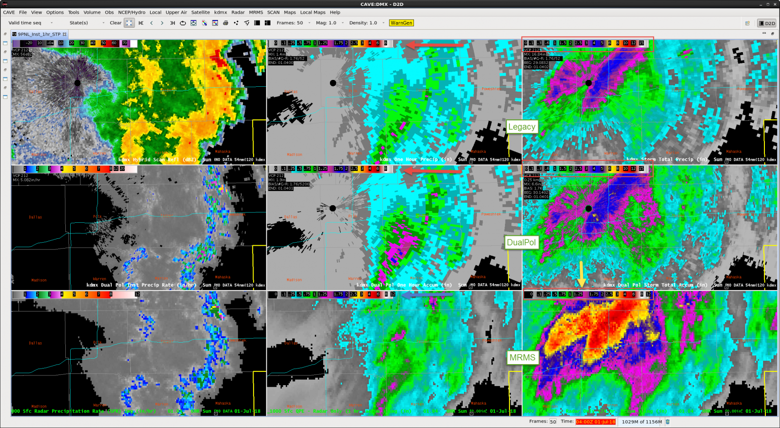
MRMS, Dual-pol, and Legacy radar estimated rainfall totals and rainfall rates from June 30, 2018.
|
Entire event radar loop showing the storms stalled and back built over the Des Moines Metro area.
|
Pella Radar Loop (Reflectivity (left), Velocity (right))
|
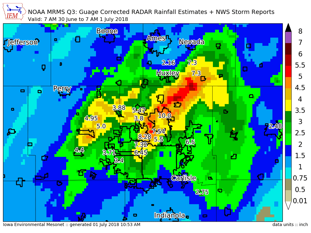
MRMS Gauge Corrected RADAR Rainfall Estimates Plus NWS Storm Reports for Des Moines Metro. |
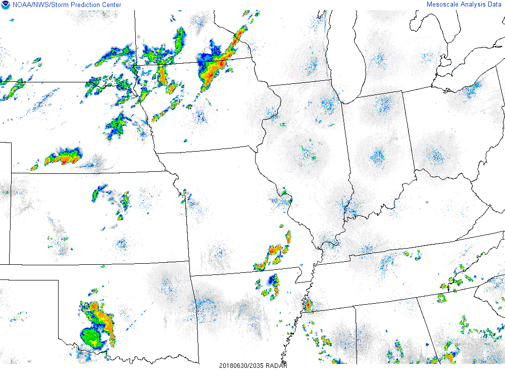
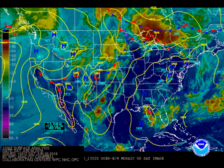
Satellite
Storm Reports
PRELIMINARY LOCAL STORM REPORT...SUMMARY
NATIONAL WEATHER SERVICE DES MOINES IA
227 AM CDT SUN JUL 1 2018
..TIME... ...EVENT... ...CITY LOCATION... ...LAT.LON...
..DATE... ....MAG.... ..COUNTY LOCATION..ST.. ...SOURCE....
..REMARKS..
0234 AM TSTM WND DMG 1 NNW RENWICK 42.84N 93.98W
06/30/2018 HUMBOLDT IA PUBLIC
SEVERAL LARGE TREES DOWN IN TOWN.
0138 PM HAIL 1 N ROLFE 42.83N 94.53W
06/30/2018 E1.00 INCH POCAHONTAS IA TRAINED SPOTTER
0151 PM HAIL ROLFE 42.81N 94.53W
06/30/2018 E1.25 INCH POCAHONTAS IA TRAINED SPOTTER
0215 PM TSTM WND GST 2 NE RUTLAND 42.78N 94.27W
06/30/2018 E60 MPH HUMBOLDT IA TRAINED SPOTTER
CORN LAID FLAT BY WIND.
0225 PM TSTM WND DMG RUTLAND 42.76N 94.29W
06/30/2018 HUMBOLDT IA TRAINED SPOTTER
LARGE BRANCHES DOWN ALONG WITH NICKLE HAIL.
0230 PM TSTM WND DMG EAGLE GROVE 42.67N 93.90W
06/30/2018 WRIGHT IA TRAINED SPOTTER
TREE DAMAGE AND ONE POWER LINE DOWN OUTSIDE
OF TOWN.
0255 PM TSTM WND DMG GOLDFIELD 42.73N 93.92W
06/30/2018 WRIGHT IA TRAINED SPOTTER
TREE LIMBS DOWN DUE TO THUNDERSTORM WINDS.
0307 PM TSTM WND DMG GOODELL 42.93N 93.61W
06/30/2018 HANCOCK IA TRAINED SPOTTER
LARGE TEE LIMBS DOWN ALL OVER TOWN.
0315 PM HAIL 1 E CLEAR LAKE 43.13N 93.35W
06/30/2018 E1.50 INCH CERRO GORDO IA PUBLIC
VIA SOCIAL MEDIA REPORT.
0620 PM HAIL 3 NNW ANKENY 41.76N 93.62W
06/30/2018 E1.00 INCH POLK IA PUBLIC
VIA SOCIAL MEDIA PICTURE.
0645 PM TSTM WND GST ZEARING 42.16N 93.30W
06/30/2018 E60 MPH STORY IA EMERGENCY MNGR
EM RELAYS TRAINED SPOTTER REPORT OF 60 TO 70
MPH WINDS BETWEEN 630 AND 800 PM.
0656 PM TSTM WND GST MINBURN 41.76N 94.03W
06/30/2018 E60 MPH DALLAS IA FIRE DEPT/RESCUE
0657 PM TSTM WND DMG 1 N ADEL 41.62N 94.03W
06/30/2018 DALLAS IA FIRE DEPT/RESCUE
MINOR DAMAGE TO TREES AND POWER
TRANSFORMERS.
0728 PM TSTM WND DMG 2 N TRAER 42.22N 92.46W
06/30/2018 TAMA IA PUBLIC
TREES DOWNS IN TRAER VIA SOCIAL MEDIA. .
0730 PM HAIL 2 S CRESTON 41.04N 94.37W
06/30/2018 E1.00 INCH UNION IA EMERGENCY MNGR
0744 PM HEAVY RAIN 2 W COLLINS 41.90N 93.35W
06/30/2018 E2.00 INCH STORY IA PUBLIC
VIA SOCIAL MEDIA.
0745 PM FLASH FLOOD 3 SE NEVADA 41.99N 93.41W
06/30/2018 STORY IA LAW ENFORCEMENT
WATER RUNNING OVER THE ROAD AT 250TH AVE AND
650TH STREET.
0800 PM FLASH FLOOD 1 ENE DALLAS CENTER 41.69N 93.97W
06/30/2018 DALLAS IA PUBLIC
WATER STANDING AND PARTIALLY BLOCKING
ROADWAYS ON THE WEST SIDE OF DALLAS CENTER.
0800 PM HEAVY RAIN MAXWELL 41.89N 93.40W
06/30/2018 M3.80 INCH STORY IA OFFICIAL NWS OBS
MAXWELL LARC RECORDED 3.8 INCHES OF HEAVY
RAINFALL SO FAR TODAY.
0805 PM FLASH FLOOD 1 E DALLAS CENTER 41.69N 93.96W
06/30/2018 DALLAS IA FIRE DEPT/RESCUE
LOCAL FIRE DEPARTMENT REPORTED NUMEROUS
ROADS IN TOWN BARELY PASSABLE OR IMPASSABLE,
AS WELL AS A PORTION OF HIGHWAY 44 WEST OF
TOWN WITH WATER OVER THE ROAD.
0805 PM HEAVY RAIN COLLINS 41.90N 93.31W
06/30/2018 E3.50 INCH STORY IA BROADCAST MEDIA
KWWL VIEWER REPORTS.
0809 PM FLOOD 2 NW SAYLORVILLE 41.71N 93.65W
06/30/2018 POLK IA EMERGENCY MNGR
ROCK CREEK OUT OF ITS BANKS IN ANKENY, IA.
0810 PM FLASH FLOOD MAXWELL 41.89N 93.40W
06/30/2018 STORY IA LAW ENFORCEMENT
FLASH FLOODING AROUND MAXWELL WITH NUMEROUS
ROADS REPORTED HAVING WATER RUNNING OVER
THEM.
0811 PM FLASH FLOOD 3 WNW ANKENY 41.74N 93.65W
06/30/2018 POLK IA PUBLIC
FLOODING AT ROCK CREEK NEAR NW 13TH STREET
IN ANKENY VIA SOCIAL MEDIA.
0820 PM FLASH FLOOD WATERLOO 42.49N 92.35W
06/30/2018 BLACK HAWK IA BROADCAST MEDIA
KWWL REPORTS FLASH FLOODING ALONG 4TH STREET
IN DOWNTOWN WATERLOO.
0827 PM FLASH FLOOD 3 SSE ALLEMAN 41.78N 93.59W
06/30/2018 POLK IA PUBLIC
SOCIAL MEDIA PICTURE OF FLOODING ALONG THE
FOURMILE.
0828 PM HEAVY RAIN MAXWELL 41.90N 93.40W
06/30/2018 E5.00 INCH STORY IA PUBLIC
SINCE 5:45 PM TODAY. STANDING WATER IN THE
AREA.
0831 PM TSTM WND DMG MENLO 41.52N 94.40W
06/30/2018 GUTHRIE IA EMERGENCY MNGR
REPORTS OF TREE BRANCHES DOWN AT LEAST 2
INCHES DIAMETER, A FEW 4 INCHES IN DIAMETER.
0840 PM FLASH FLOOD 3 SSW NEVADA 41.98N 93.46W
06/30/2018 STORY IA EMERGENCY MNGR
WATER OVER ROAD ALONG 620TH AVE APPROX 3
MILES SOUTH OF NEVEDA.
0848 PM HEAVY RAIN 2 ENE URBANDALE 41.64N 93.71W
06/30/2018 E2.68 INCH POLK IA PUBLIC
2.68 INCHES OF RAIN MEASURED 8:47 PM.
MULTIPLE CARS STALLED ON MEREDITH AVE. 8" OF
WATER RUSHING DOWN 67TH STREET TO MEREDITH.
0849 PM FLASH FLOOD 2 ENE URBANDALE 41.64N 93.71W
06/30/2018 POLK IA PUBLIC
2.68 INCHES OF RAIN MEASURED 8:47 PM.
MULTIPLE CARS STALLED ON MEREDITH AVE. 8" OF
WATER RUSHING DOWN 67TH STREET TO MEREDITH.
0850 PM TSTM WND DMG 2 ENE URBANDALE 41.64N 93.71W
06/30/2018 POLK IA TRAINED SPOTTER
REPORT VIA SOCIAL MEDIA. LARGE TREE BRANCHES
DOWN 6 TO 10 INCHES IN DIAMETER.
0850 PM TSTM WND DMG 2 N WINDSOR HEIGHTS 41.63N 93.71W
06/30/2018 POLK IA PUBLIC
7 INCH TREE BRANCH DOWN AT 67TH AND
MEREDITH.
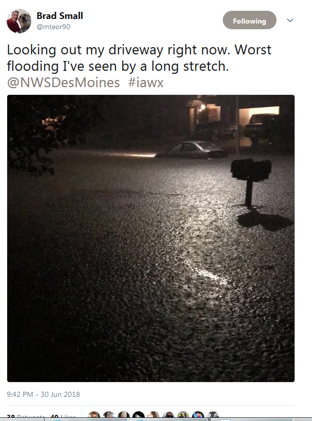
0852 PM FLASH FLOOD 1 N ANKENY 41.74N 93.60W
06/30/2018 POLK IA PUBLIC
SOCIAL MEDIA PICTURE OF WATER COVERING
RESIDENTIAL STREET AT NW 9TH AND SCHOOL
STREET IN ANKNEY.
0856 PM FLASH FLOOD 1 E CLIVE 41.61N 93.75W
06/30/2018 POLK IA TRAINED SPOTTER
TRAINED SPOTTER IN CLIVE REPORTS WATER
RUNNING OVER THE CURBS ON RESIDENTIAL
STREETS SOUTH OF HICKMAN DRIVE.
0857 PM FLASH FLOOD 3 NNE ANKENY 41.77N 93.58W
06/30/2018 POLK IA PUBLIC
DELAWARE AVE UNDER WATER NORTH OF NE 36TH
STREET IN ANKENY, IA.
0902 PM FLASH FLOOD COLLINS 41.90N 93.31W
06/30/2018 STORY IA EMERGENCY MNGR
EM REPORTS THAT CITIZEN ESTIMATES 4 INCHES
OF WATER OVER HWY 65 AT 4TH STREET IN
COLLINS, IA.
0903 PM TSTM WND DMG WINTERSET 41.34N 94.02W
06/30/2018 MADISON IA LAW ENFORCEMENT
ROOF BLOWN OFF A HOUSE AND A LARGE TREE DOWN
IN TOWN.
0906 PM TSTM WND GST 2 NW PANORA 41.71N 94.38W
06/30/2018 E58 MPH GUTHRIE IA TRAINED SPOTTER
0907 PM TSTM WND GST 2 NW PANORA 41.71N 94.40W
06/30/2018 E58 MPH GUTHRIE IA TRAINED SPOTTER
0913 PM HEAVY RAIN 1 SE JOHNSTON 41.68N 93.69W
06/30/2018 E5.60 INCH POLK IA PUBLIC
5.6 INCHES VIA SOCIAL MEDIA.
0922 PM FLASH FLOOD 2 SSE WINDSOR HEIGHTS 41.58N 93.70W
06/30/2018 POLK IA PUBLIC
63RD AND GRAND NEAR WEST DES MOINES REPORTED
UNDERWATER VIA SOCIAL MEDIA.
0925 PM FLASH FLOOD 3 NNE ANKENY 41.76N 93.58W
06/30/2018 POLK IA PUBLIC
SOCIAL MEDIA REPORTS MULTIPLE VEHICLES
STALLED ALONG DELAWARE AVE IN ANKNEY.
0928 PM FLASH FLOOD 2 ENE ANKENY 41.74N 93.56W
06/30/2018 POLK IA TRAINED SPOTTER
UPS VEHICLE RESCUES HAVE TAKEN PLACE. WATER
WAS ABOUT CHEST DEEP IN SOME AREAS.
0939 PM FLASH FLOOD SAYLORVILLE 41.69N 93.63W
06/30/2018 POLK IA EMERGENCY MNGR
MULTIPLE WATER RESCUES ACROSS ANKENY,
JOHNSTON, DES MOINES AND URBANDALE. VEHICLES
STALLED OUT IN STREET FLOODING WITH WATER
HALF WAY UP THE DOORS OF THE CARS.
0942 PM FLASH FLOOD 2 SE GRIMES 41.67N 93.76W
06/30/2018 POLK IA PUBLIC
WATER COVERING THE ROAD IN THE AREA.
0944 PM HEAVY RAIN 1 NNW WINDSOR HEIGHTS 41.62N 93.72W
06/30/2018 M7.30 INCH POLK IA PUBLIC
REPORT VIA SOCIAL MEDIA. 7.3 INCHES REPORTED
FROM URBANDALE.
1016 PM HEAVY RAIN 2 NNE ANKENY 41.75N 93.59W
06/30/2018 E10.00 INCH POLK IA PUBLIC
10 INCHES OF RAIN REPORTED ON THE NORTH SIDE
OF ANKENY AS OF 1015 PM.
1022 PM HEAVY RAIN 2 ENE URBANDALE 41.64N 93.71W
06/30/2018 E7.32 INCH POLK IA PUBLIC
7.32 INCHES AT 67TH AND MEREDITH IN
URBANDALE AS OF 1022 PM.
1028 PM HEAVY RAIN 1 S SAYLORVILLE 41.66N 93.62W
06/30/2018 E5.50 INCH POLK IA PUBLIC
5.5 INCHES SINCE 7:30 PM.
1041 PM HEAVY RAIN 1 ESE ALTOONA 41.65N 93.46W
06/30/2018 E6.50 INCH POLK IA PUBLIC
6.5 INCHES IN ALTOONA SINCE 8 PM.
1044 PM HEAVY RAIN JOHNSTON 41.68N 93.70W
06/30/2018 E7.10 INCH POLK IA AMATEUR RADIO
7.1 INCHES OF RAIN IN JOHNSTON, IA AS OF
1043 PM CDT.
1049 PM FLASH FLOOD 3 ENE WINDSOR HEIGHTS 41.63N 93.67W
06/30/2018 POLK IA PUBLIC
REPORT VIA SOCIAL MEDIA. STREET AND GUARD
RAILS BEING WASHED AWAY WITH THE GROUND
DETERIORATING.
1112 PM HEAVY RAIN 1 NE WATERLOO 42.50N 92.33W
06/30/2018 E2.05 INCH BLACK HAWK IA BROADCAST MEDIA
KWWL REPORTS.
1116 PM HEAVY RAIN 1 S SAYLORVILLE 41.67N 93.62W
06/30/2018 M7.50 INCH POLK IA PUBLIC
1124 PM HEAVY RAIN 1 SSE SAYLORVILLE 41.67N 93.62W
06/30/2018 E7.50 INCH POLK IA PUBLIC
7.50 INCHES NEAR SAYLORVILLE AREA IN RURAL
POLK COUNTY AS OF 1124 PM CDT.
1242 AM HEAVY RAIN 3 SSE ALLEMAN 41.77N 93.58W
07/01/2018 E6.92 INCH POLK IA TRAINED SPOTTER
6.92 INCHES AS OF 1242 AM.
0524 AM     HEAVY RAIN       2 NW MAXWELL            41.91N 93.43W
07/01/2018  M7.30 INCH       STORY              IA   TRAINED SPOTTER

            STORM TOTAL OF 7.3 INCHES NORTHWEST OF
            MAXWELL.
Environment
 |
 |
 |
|
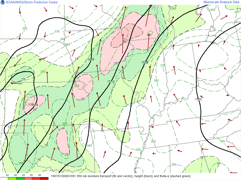
Figure 1: 850 mb moisture transport (fill and vector), height (black), and thete-e (dashed green). The loop begins at 00 UTC 1 JUL 2018 and ends at 09 UTC 1 JUL 2018. |
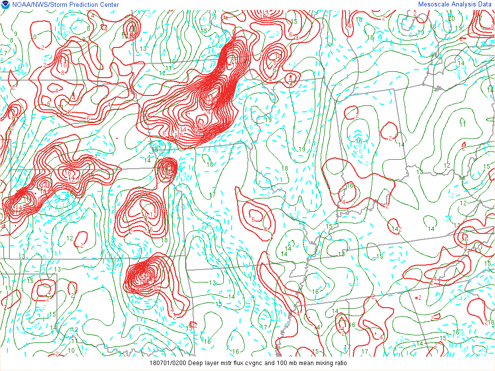
Figure 2: Deep layer moisture flux convergence and 100 mb mean mixing ratio from 02 UTC 01 JUL 2018 to 09 UTC JUL 2018. |
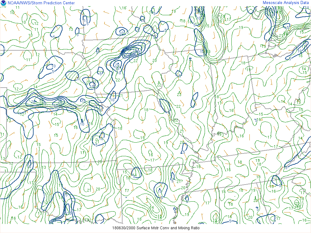
Figure 3: Surface moisture convergence and mixing ratio from 20 UTC 30 JUN 2018 to 09 UTC 01 JUL 2018. |
 |
 |
 |
|
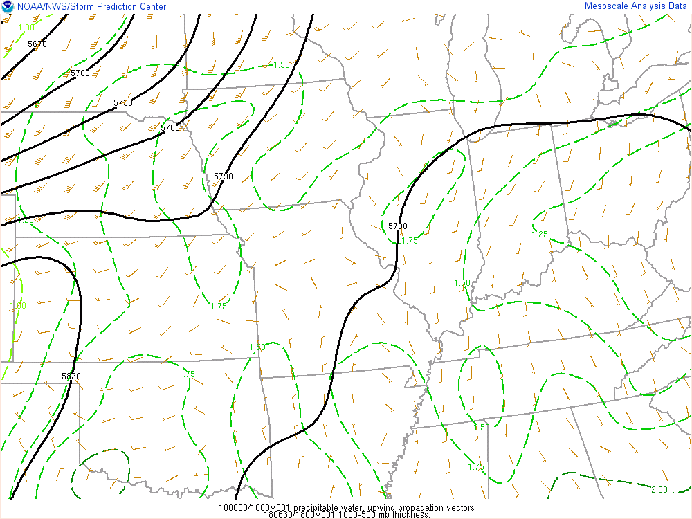
Figure 4: Precipitable water, upwind propagation vectors and 1000-500 mb thickness from 18 UTC 30 JUN 2018 to 11 UTC JUL 2018. |
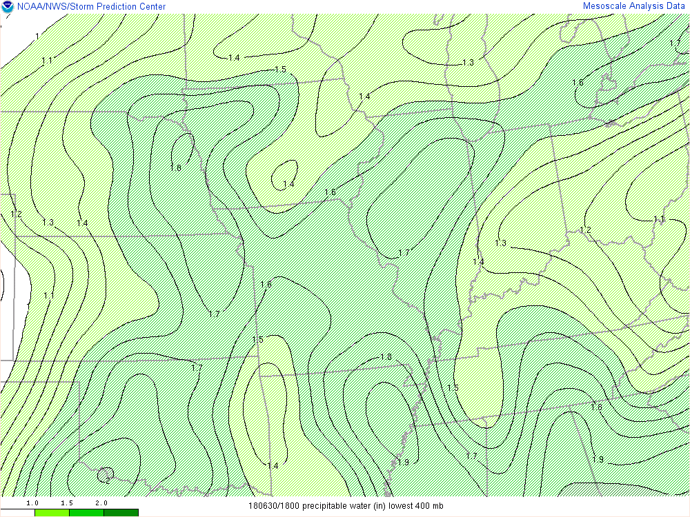
Figure 5: Precipitable water (inches) in the lowest 400 mb. |
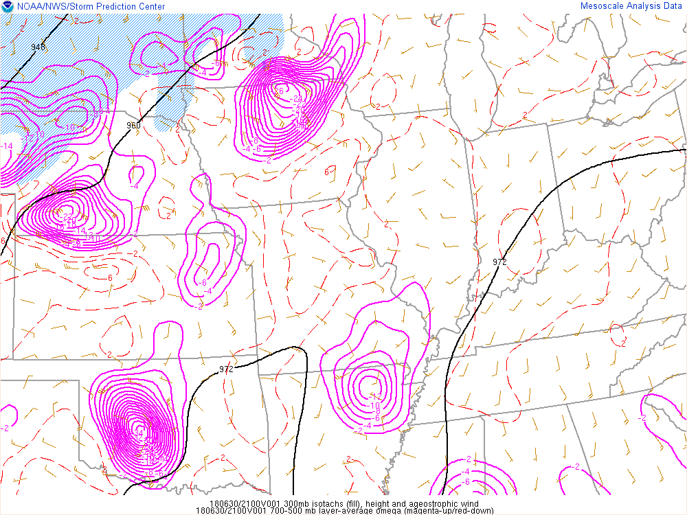
Figure 6: 300 mb isotachs (fill), height and ageostrophic wind, 700-500 mb layer-average omega (magenta = up and red =down). |
 |
 |
 |
| Figure 7: A loop of the 850 mb heights shows a strong shortwave moving across central Iowa during the overnight into Sunday morning. Also it shows the strong low level jet pumping in an abundance of moisture into central Iowa. | Figure 8: A loop of the 700 mb heights also shows the strong shortwave trough pushing over northern Iowa between 7 p.m. to 7 a.m. CT Saturday night into Sunday the 1st. | Figure 9: Loop of surface analysis contains analysis every 3 hours from the morning of Saturday, June 30, 2018 to Sunday morning July 1, 2018. |
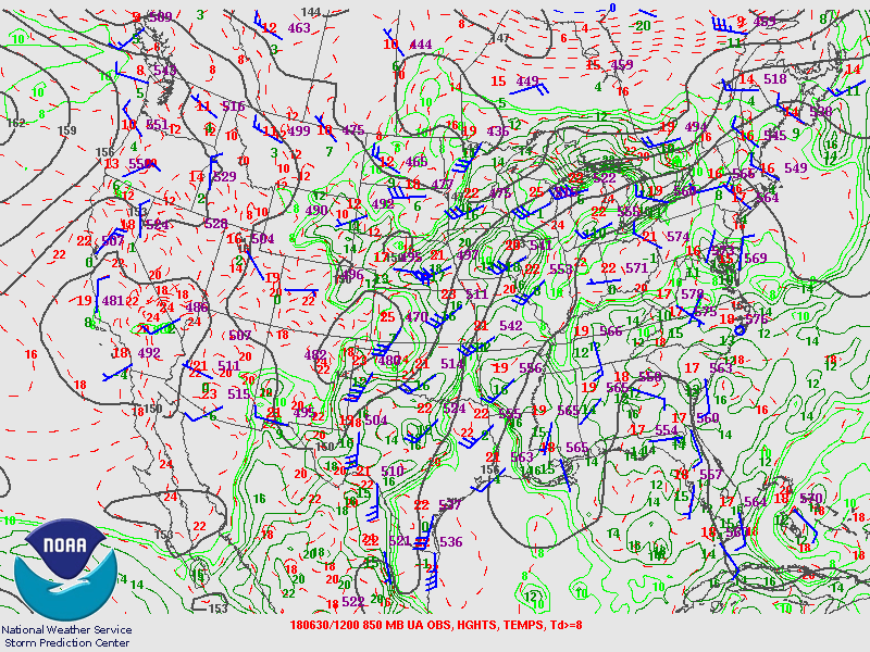
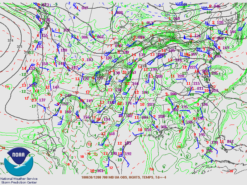
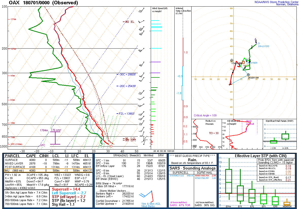
Below are upper air soundings from Omaha, Nebraska and Davenport, Iowa on the evening of June 30, 2018.
 |
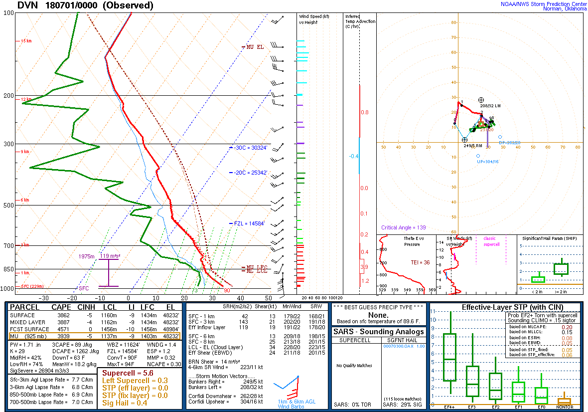 |
| Figure 10: Omaha sounding at 7 p.m. CT Saturday, June 30, 2018. | Figure 11: Davenport sounding at 7 p.m. CT Saturday, June 30, 2018. |
 |
Media use of NWS Web News Stories is encouraged! Please acknowledge the NWS as the source of any news information accessed from this site. |
|

